
Atmospheric Circulation and Weather Systems | CBSE Class 11 Geography Notes
On this page
Watch & explore
Start with a few high-quality watches, then dive into the notes below.
This note covers atmospheric pressure, pressure belts, forces controlling wind, general atmospheric circulation, ocean interactions, seasonal and local winds, air masses, fronts, extra tropical cyclones, tropical cyclones, thunderstorms and tornadoes.
What is atmospheric pressure, and how does it change with height?
Atmospheric pressure is the weight of the air column over a unit area, extending from mean sea level to the top of the atmosphere. Mean sea level is the average level of the sea surface, used as a reference for elevations. A mercury barometer or an aneroid barometer measures air pressure.
Pressure is expressed in millibars, abbreviated as mb. Average atmospheric pressure at sea level is 1,013.2 mb. Gravity, the downward pull on air, makes air denser near the surface, where pressure is higher.
How do temperature and pressure start air moving?
Heated air expands, while cooled air becomes compressed. These differences produce variations in atmospheric pressure. Wind is air moving horizontally, from areas of high pressure towards areas of low pressure. Differences in pressure also help determine whether air rises or sinks.
Wind redistributes heat and moisture across the planet. Rising moist air cools, helping clouds and precipitation, or water falling from clouds, to form. Horizontal movement and vertical movement therefore have different but connected roles in atmospheric circulation.
What do the standard atmosphere values show?
In the lower atmosphere, pressure decreases rapidly with height, by about 1 mb for each 10 m increase in elevation. Here m means metre, km means kilometre, and °C means degrees Celsius. The rate of decrease is not always the same.
| Elevation | Pressure in mb | Temperature in °C |
|---|---|---|
| Sea level | 1,013.25 | 15.2 |
| 1 km | 898.76 | 8.7 |
| 5 km | 540.48 | −17.3 |
| 10 km | 265.00 | −49.7 |
These selected values describe a standard atmosphere, a reference set of atmospheric conditions at different elevations. The vertical pressure gradient force, produced by pressure differences with height, is much larger than the horizontal pressure gradient force.
Note: The vertical pressure gradient force is generally balanced by a nearly equal, opposite gravitational force. This explains why a large vertical pressure difference does not produce strong upward winds in ordinary conditions.
How do isobars reveal pressure systems and global pressure belts?
Isobars connect places with equal atmospheric pressure. Drawing them at a constant level reveals the horizontal distribution of pressure. Even small pressure differences are highly significant for wind direction and velocity. Velocity describes speed together with direction.
Pressure measured at a station is reduced to sea level before comparison. This removes the effect of the station's altitude, or height, on pressure. Weather maps therefore show sea level pressure rather than comparing unadjusted readings from different elevations.
How are highs and lows arranged?
A low-pressure system has its lowest pressure at the centre, enclosed by one or more isobars. A high-pressure system has its highest pressure at the centre. The major global pressure belts occupy broadly different latitudes, or angular distances north and south of the equator.
In the table, ° means degrees of latitude, N means north and S means south. Pressure belts are the broad zones of high or low pressure extending around the earth.
| Pressure belt | Position | Pressure condition |
|---|---|---|
| Equatorial low | Near the equator | Low pressure |
| Subtropical highs | Along 30° N and 30° S | High pressure |
| Subpolar lows | Along 60° N and 60° S | Low pressure |
| Polar highs | Near the poles | High pressure |
These belts are not permanent in position. They oscillate with the sun's apparent movement. In the northern hemisphere, the half of the earth north of the equator, they move southwards in winter and northwards in summer.
What changes between the January and July maps?
On pressure maps, H denotes high pressure and L denotes low pressure. The Inter Tropical Convergence Zone, abbreviated ITCZ, is the low-pressure zone where winds from the tropics meet. The January and July maps show how pressure patterns differ seasonally.
What the figure shows
January pressure distribution
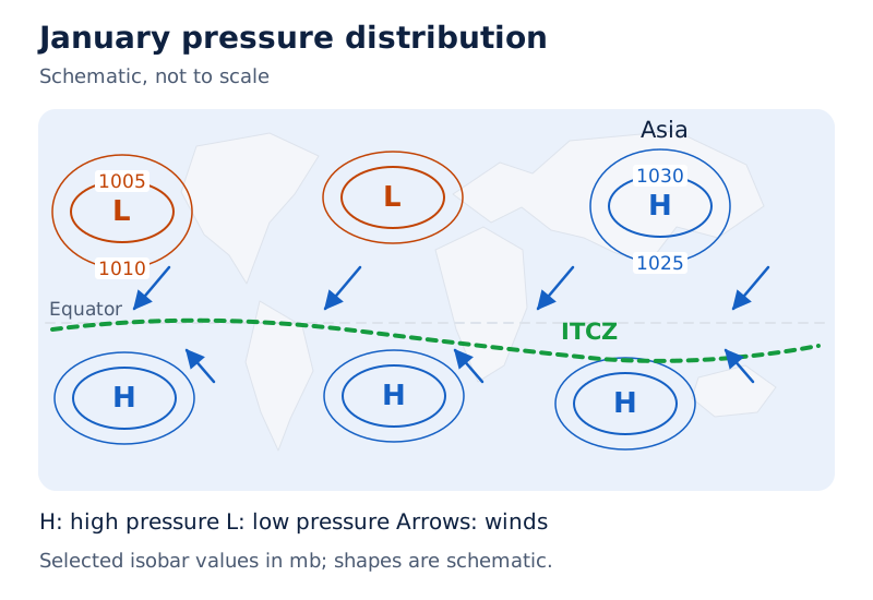
Numbered isobars cross a world outline, with H and L marking pressure centres and arrows showing winds. A prominent high lies over Asia. The ITCZ is labelled near the equatorial region.
Drawn by One Young India. See Fig. 9.2 in your NCERT textbook
What the figure shows
July pressure distribution
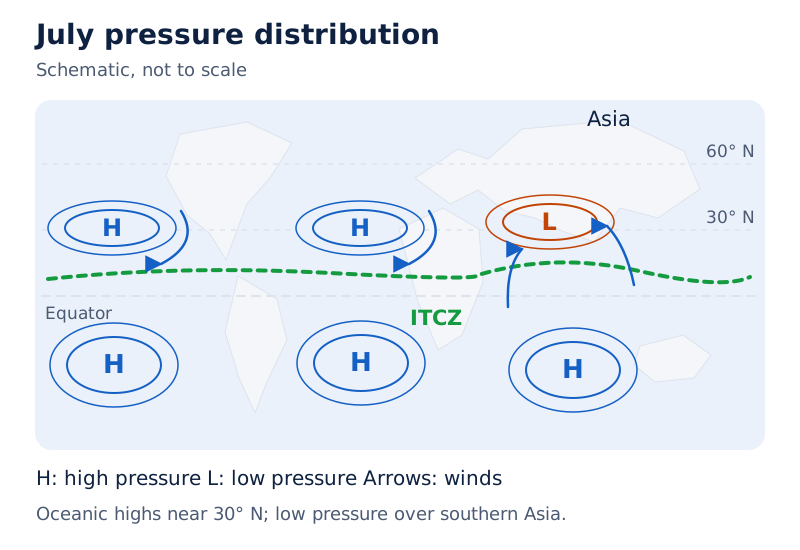
A low is marked over Asia, with surrounding isobars and wind arrows. Highs appear over the oceans. Compare the Asian low with January's Asian high and trace the labelled ITCZ.
Drawn by One Young India. See Fig. 9.3 in your NCERT textbook
Which forces control the speed and direction of wind?
Horizontal winds near the earth's surface respond to three forces acting together: the pressure gradient force, the frictional force and the Coriolis force. These respectively arise from pressure differences, resistance near the surface and the earth's rotation. Gravity also acts downwards.
How does the pressure gradient influence wind?
The pressure gradient is the rate at which pressure changes with distance. Closely spaced isobars indicate a strong gradient; widely spaced isobars indicate a weak gradient. The pressure gradient force acts perpendicular, or at right angles, to an isobar.
A higher pressure gradient force produces greater wind velocity. Isobar spacing therefore helps interpret the force driving the air, while the other forces help explain why the resulting wind does not simply follow a straight path towards low pressure.
How do friction and rotation modify movement?
Friction affects wind speed. It is greatest at the earth's surface, and its influence generally extends to an elevation of 1 to 3 km. Friction over the sea surface is minimal.
The Coriolis force changes wind direction because the earth rotates about its axis. It deflects winds to the right in the northern hemisphere and to the left in the southern hemisphere, the half of the earth south of the equator.
Deflection is greater when wind velocity is high. The Coriolis force is maximum at the poles and absent at the equator. Latitude and wind velocity therefore matter when considering the direction taken by moving air.
| Force | Main influence | Important condition |
|---|---|---|
| Pressure gradient force | Sets air in motion through pressure differences | Stronger where isobars are close |
| Frictional force | Affects wind speed | Greatest at the surface |
| Coriolis force | Deflects moving air | Absent at the equator |
At the equator, wind blows perpendicular to the isobars because the Coriolis force is zero. Low pressure becomes filled instead of intensifying. This explains why tropical cyclones, violent storms originating over tropical oceans, do not form near the equator.
How do geostrophic winds and circulation around pressure centres work?
Wind velocity and direction reflect the combined action of the forces controlling movement. Winds in the upper atmosphere, 2 to 3 km above the surface, are free from surface friction and are controlled mainly by the pressure gradient and Coriolis forces.
What conditions produce geostrophic wind?
When isobars are straight and friction is absent, the pressure gradient force balances the Coriolis force. The resulting wind flows parallel to the isobars. This is called geostrophic wind. Both the straight-isobar condition and the absence of friction are part of the explanation.
What the figure shows
Geostrophic wind
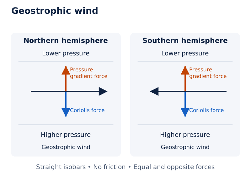
Paired sketches show straight isobars for the northern and southern hemispheres. The wind arrows run parallel to the lines, while the force arrows oppose each other across them.
Drawn by One Young India. See Fig. 9.4 in your NCERT textbook
How do cyclonic and anticyclonic circulation differ?
Cyclonic circulation means wind circulation around a low-pressure centre. Anticyclonic circulation means circulation around a high-pressure centre. Their rotation reverses between hemispheres, so identifying the pressure centre alone is insufficient to state the rotation direction.
| System | Central pressure | Northern hemisphere | Southern hemisphere |
|---|---|---|---|
| Cyclone | Low | Anticlockwise | Clockwise |
| Anticyclone | High | Clockwise | Anticlockwise |
Convergence means air coming together; divergence means air spreading apart. Generally, air converges and rises over low pressure. Over high pressure, air subsides, or sinks from above, and diverges at the surface. Surface circulation is on many occasions closely related to circulation higher up.
What the figure shows
Convergence and divergence
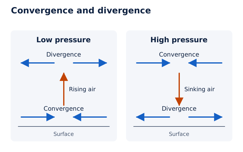
Arrows converge near the surface below the low, rise and diverge above. The high shows the reverse arrangement: convergence above, descent and divergence at the surface.
Drawn by One Young India. See Fig. 9.5 in your NCERT textbook
Air can also rise through convection, the upward movement of heated air; eddies, or swirling movements; orographic uplift, which is ascent over relief; and uplift along fronts, the boundaries between different air masses. An air mass is a large body of air with little horizontal variation in temperature and moisture. Such rising air is essential for cloud formation and precipitation.
How do the three circulation cells organise planetary winds?
General atmospheric circulation is the pattern of movement of planetary winds, the winds forming the global circulation system. Heat transfer from lower to higher latitudes maintains it. This circulation also sets ocean water in motion and thereby influences the earth's climate.
The pattern largely depends on latitudinal differences in atmospheric heating, the emergence of pressure belts, their migration with the sun's apparent path, the distribution of continents and oceans, and the earth's rotation. These factors explain why circulation includes both a global pattern and seasonal changes.
How does the Hadley cell operate?
A cell is a circulation linking surface and upper air movements. The tropical cell is the Hadley cell. At the ITCZ, high insolation, meaning incoming solar radiation, drives convection and creates low pressure.
- Winds from the tropics converge at the ITCZ, where heated air rises with the convective cell.
- The rising air reaches the top of the troposphere, the lowest atmospheric layer, up to an altitude of 14 km, and moves towards the poles.
- Air accumulates at about 30° N and 30° S. Part of it sinks, producing subtropical high pressure; cooling at these latitudes is another reason for sinking.
- Near the surface, air returns towards the equator as easterlies, winds blowing from the east, also labelled trade winds in the tropical circulation. Easterlies from both sides converge again at the ITCZ.
What happens in the middle and polar latitudes?
The Ferrel cell occupies middle latitudes. Its circulation includes sinking cold air coming from the poles and rising warm air from the subtropical highs. The surface winds are westerlies, winds blowing from the west.
In the polar cell, cold, dense air subsides near the poles and moves towards middle latitudes as polar easterlies. Together, the Hadley, Ferrel and polar cells establish the general circulation pattern.
What the figure shows
General atmospheric circulation
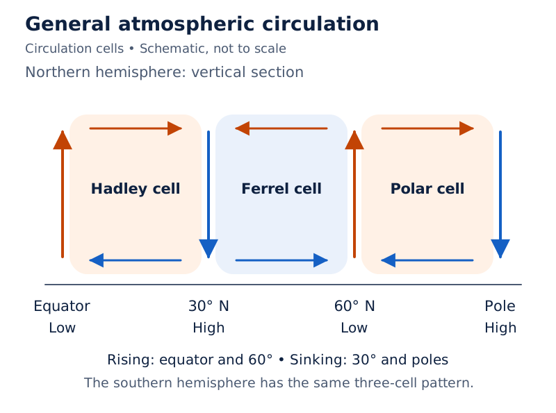
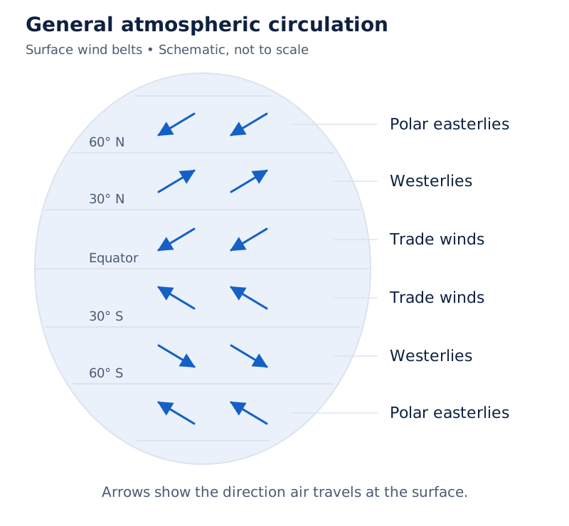
The globe sketch labels Hadley, Ferrel and polar cells. It places trade winds near the equator, westerlies in middle latitudes and polar easterlies towards the poles, with arrows showing circulation.
Drawn by One Young India. See Fig. 9.6 in your NCERT textbook
How do circulation, oceans and seasonal shifts affect weather?
Atmospheric circulation and ocean circulation influence each other. Large-scale winds initiate large, slow-moving ocean currents, or movements of ocean water. The oceans return energy and water vapour to the atmosphere. These exchanges occur rather slowly across large parts of the ocean.
Case study: How does the Pacific ENSO phenomenon affect distant regions?
Warm water in the central Pacific slowly drifts towards the South American coast, replacing the cool Peruvian current. The appearance of this warm water off Peru is called El Nino. Warming and cooling of the Pacific are most important in terms of general atmospheric circulation.
El Nino is closely associated with pressure changes in the central Pacific and Australia. This pressure change is the southern oscillation. Its combination with El Nino is called ENSO, meaning the combined El Nino and southern oscillation phenomenon.
In years when ENSO is strong, large-scale weather variations occur worldwide. The arid, or dry, western coast of South America receives heavy rain; Australia experiences drought; drought occurs sometimes in India; and China experiences floods. Drought means a shortage of rainfall.
This ocean-atmosphere connection is closely monitored and used for long-range forecasting in major parts of the world. The regional effects connect a change in Pacific water and pressure conditions with weather far beyond the immediate Peruvian coast.
Why do wind patterns change with the seasons?
Regions of maximum heating shift seasonally, along with pressure and wind belts. Their movement modifies wind circulation. The most pronounced effect is seen in the monsoons, seasonal wind circulation, especially over southeast Asia. Daily and annual heating differences also generate local and regional winds.
Why do coastal and mountain winds reverse between day and night?
Local winds arise from differences in the heating and cooling of nearby surfaces. Land and sea absorb and transfer heat differently. Mountain slopes and valleys also develop contrasting conditions through the daily cycle. These contrasts create local air movements within the wider circulation system.
How do sea and land breezes form?
- During the day, land heats faster than the sea and becomes warmer.
- Air over the land rises, creating low pressure, while the relatively cool sea has relatively high pressure.
- The pressure gradient is directed from sea to land, producing a sea breeze, the surface wind from sea towards land.
- At night, land loses heat faster and becomes cooler than the sea. The gradient reverses, producing a land breeze from land towards sea.
What the figure shows
Land and sea breezes
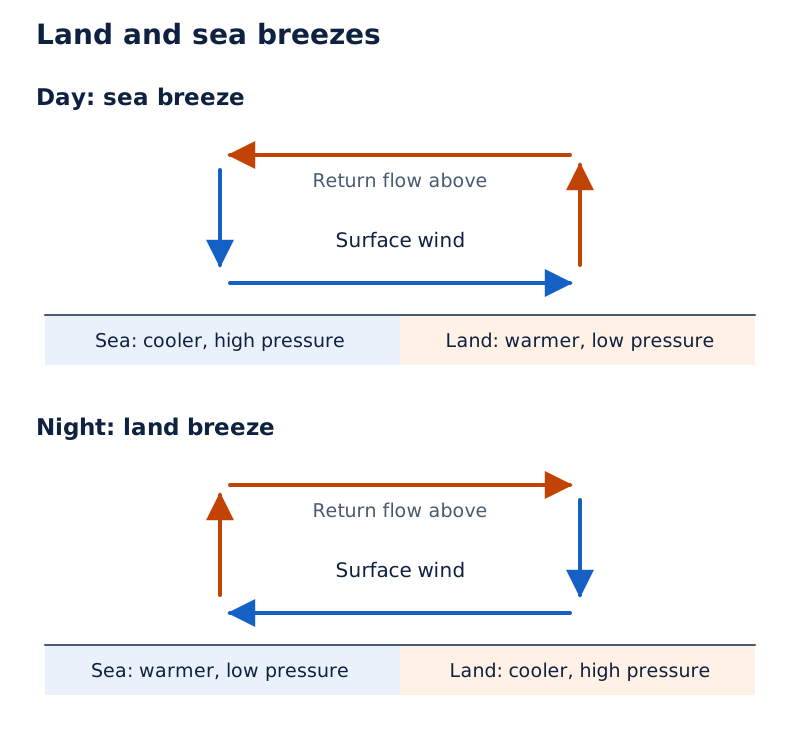
The upper sketch shows surface arrows from sea towards land and a return flow above. The lower sketch reverses the arrows, showing the surface land breeze and its return circulation.
Drawn by One Young India. See Fig. 9.7 in your NCERT textbook
How do valley, mountain and katabatic winds differ?
During the day, mountain slopes warm and air moves upslope. Air from the valley moves up to fill the gap, forming a valley breeze. At night the slopes cool, and dense air descends into the valley as a mountain wind.
A katabatic wind is cool air draining into a valley from high plateaus and ice fields. It is identified by its cold source and downward drainage. The daytime valley breeze is associated with heated slopes and ascending air.
Another warm wind occurs on the leeward side, the side reached as air descends after crossing a mountain range. Moisture condenses, changing from vapour to liquid, and precipitates during the crossing. Descending dry air then warms through an adiabatic process, temperature change without heat exchange with its surroundings.
Note: Warm, dry air descending the leeward slope may melt snow in a short time.
What are air masses, and how do their source regions differ?
An air mass is a large body of air with little horizontal variation in temperature and moisture. Its humidity, or moisture content, and temperature give it distinctive characteristics. Air develops these characteristics when it remains over a homogeneous area for a sufficiently long time.
A homogeneous area has broadly similar surface conditions across it. Vast ocean surfaces and extensive plains can provide such areas. The surfaces over which air masses develop are called source regions. Classification follows these source regions.
Which five source regions produce the main air masses?
Maritime means associated with an ocean source, while continental means associated with a land source. Tropical air masses are warm, and polar air masses are cold. Each abbreviation below is introduced beside its complete name.
| Source region | Air mass type | Abbreviation |
|---|---|---|
| Warm tropical and subtropical oceans | Maritime tropical | mT |
| Subtropical hot deserts | Continental tropical | cT |
| Relatively cold oceans at high latitudes | Maritime polar | mP |
| Very cold, snow-covered continents at high latitudes | Continental polar | cP |
| Permanently ice-covered continents in the Arctic and Antarctica | Continental arctic | cA |
The classification connects the properties of the air to the surface over which it has remained. A brief passage across a surface is different from the sufficiently long residence needed to acquire the source region's characteristics.
Definition: An air mass has little horizontal variation in temperature and moisture. “Little variation” does not mean that every part must have exactly identical conditions. Both temperature and moisture belong in the definition.
Distinct air masses can subsequently meet. Their boundary becomes important because differences in temperature and pressure can force air upwards, produce clouds and precipitation, and cause abrupt changes in weather.
What are fronts, and how do their four types differ?
A front is the boundary zone where two different air masses meet. Frontogenesis means the formation of fronts. Fronts occur in middle latitudes and have steep temperature and pressure gradients, meaning sharp changes in these conditions across a short distance.
Frontal passage brings abrupt temperature changes. Air is forced upwards, helping clouds and precipitation to develop. The direction in which the air masses move, or the lifting of an air mass above the ground, determines the type of front.
How can each front be identified?
| Front | Identifying condition | Distinction to remember |
|---|---|---|
| Cold front | Cold air moves towards warm air | The advancing air is cold |
| Warm front | Warm air moves towards cold air | The advancing air is warm |
| Stationary front | The front remains stationary | The boundary is not advancing |
| Occluded front | An air mass is fully lifted above the land surface | The lifted air no longer reaches the ground |
What the figure shows
Vertical sections of fronts
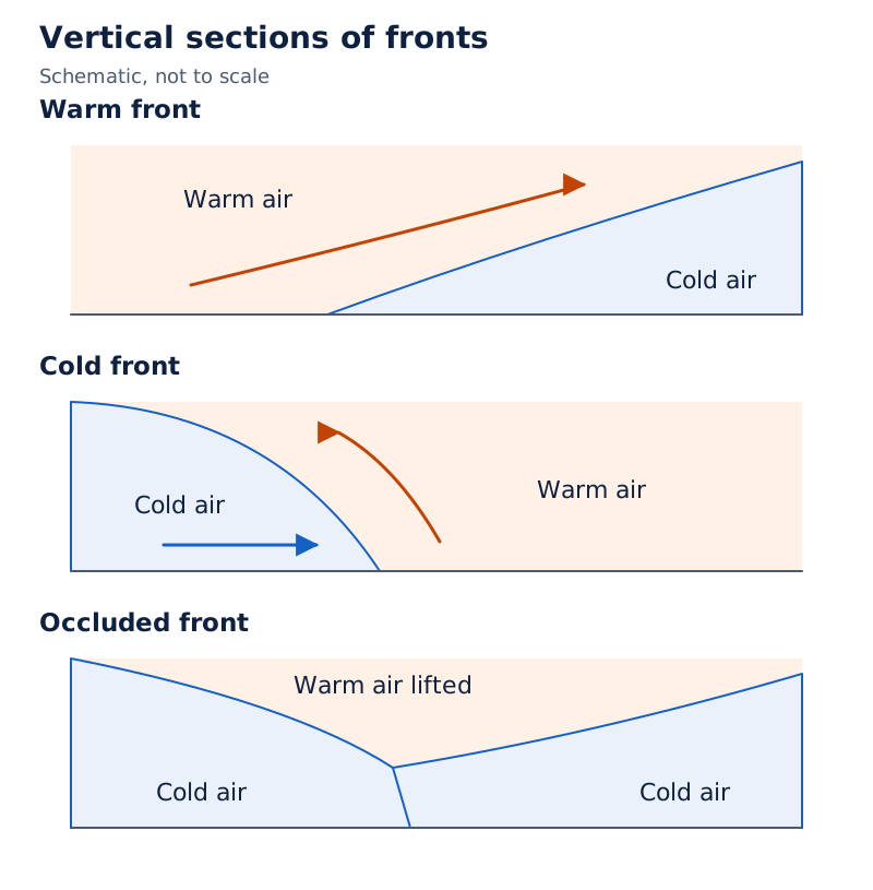
The warm-front and cold-front sketches label warm and cold air on opposite sides of sloping boundaries. The occluded-front sketch shows warm air raised above the surface between areas labelled cold air.
Drawn by One Young India. See Fig. 9.8 in your NCERT textbook
For a warm or cold front, begin by identifying which air mass is moving towards the other. For an occluded front, focus on the complete lifting of an air mass. These are distinct relationships, even though all belong to the same broader system of air-mass boundaries.
Fronts also help explain extra tropical cyclones, the systems developing beyond the tropics in middle and high latitudes. Their formation, cloud development and eventual weakening are closely connected with the interaction of warm and cold air.
How does an extra tropical cyclone develop and weaken?
Extra tropical cyclones, also called middle-latitude cyclones, develop in middle and high latitudes beyond the tropics. They form along the polar front, where warm air and cold polar air meet. Their fronts produce abrupt weather changes as they pass over an area.
What sequence produces the mature cyclone?
- Initially, the polar front is stationary. In the northern hemisphere, warm air blows from the south and cold air from the north of the front.
- Pressure falls along the front. Warm air moves northwards and cold air moves southwards, starting an anticlockwise cyclonic circulation.
- The circulation develops a warm front and a cold front. A warm sector, a pocket of warm air, lies between areas of cold air called the cold sector.
- Warm air glides over cold air ahead of the warm front. A sequence of clouds appears and precipitation follows.
- The cold front approaches from behind, pushes warm air upwards and produces cumulus clouds, clouds with a piled or heaped appearance, along the cold front.
- The faster cold front overtakes the warm front. Warm air is completely lifted, the front becomes occluded and the cyclone dissipates, meaning it weakens and dies away.
What the figure shows
Extra tropical cyclone
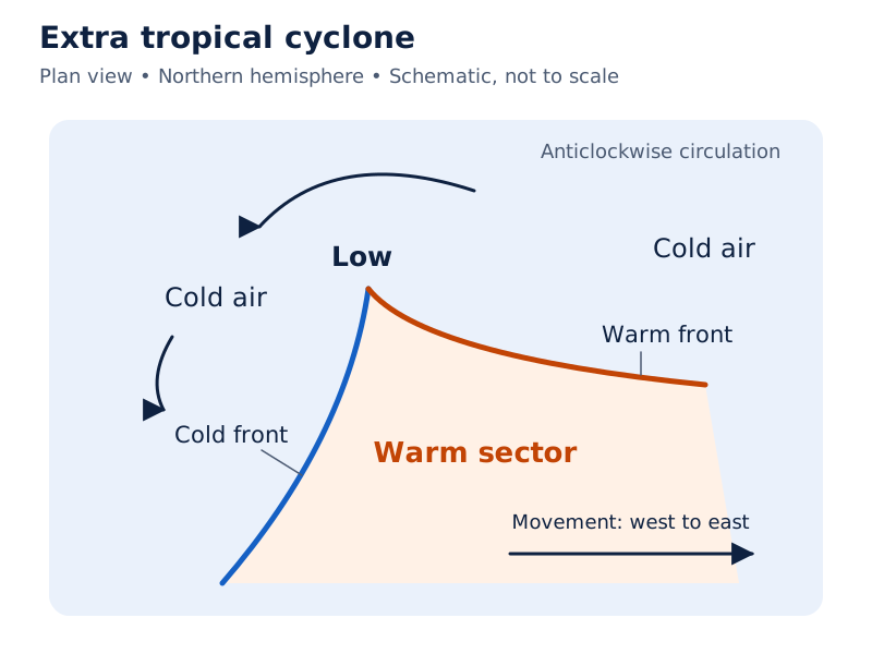
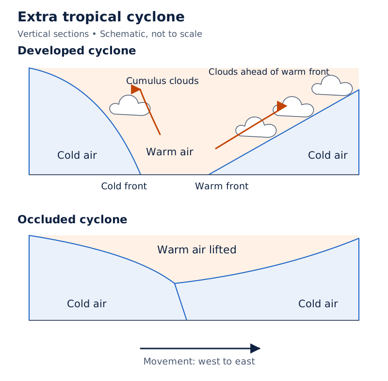
The plan view labels a warm-air sector between warm and cold fronts, with cold air around it. Vertical sections show warm air above cold air, clouds and the direction of movement.
Drawn by One Young India. See Fig. 9.9 in your NCERT textbook
How does it compare with a tropical cyclone?
| Feature | Extra tropical cyclone | Tropical cyclone |
|---|---|---|
| Frontal system | Clear warm and cold fronts | No clear frontal system |
| Origin | Over land or sea | Only over seas |
| Area affected | Much larger area | Smaller area in comparison |
| Wind and destruction | Lower wind velocity in comparison | Much higher wind velocity and more destructive |
| Movement | West to east | East to west |
Surface and upper-air circulation remain closely interlinked during cyclone development. The presence of a clear frontal system is an important distinction between extra tropical and tropical cyclones, as are their places of origin and the areas they affect.
Why do tropical cyclones intensify over warm seas?
Tropical cyclones originate over tropical oceans and move towards coastal areas. Violent winds, very heavy rain and storm surges, storm-driven rises of sea water that flood coastal lowlands, cause large-scale destruction. Warm ocean conditions support both their formation and intensification.
Which conditions favour their development?
- A large sea surface with temperature higher than 27°C.
- The presence of the Coriolis force.
- Small variations in vertical wind speed, meaning small changes of wind speed with height.
- A pre-existing weak low-pressure area or low-level cyclonic circulation.
- Upper divergence, or air spreading out above the sea level system.
Energy released through condensation in towering cumulonimbus clouds, strongly developed storm clouds, intensifies the cyclone. These clouds surround its centre. Continued moisture supply from the sea strengthens the storm, while reaching land cuts off that supply and causes dissipation.
Landfall is the place where the cyclone crosses the coast. Cyclones crossing 20° N generally recurve, meaning their track bends, and they are more destructive. The word “generally” matters when describing this change of direction.
How do the eye and eye wall differ?
The eye is the central calm region, with subsiding air. Strong winds spiral around it. The surrounding eye wall contains strongly ascending, spiralling air reaching the tropopause, the upper boundary of the troposphere. Maximum wind velocity and torrential rain occur in the eye wall.
Rain bands, bands of rain-bearing clouds, may radiate from the eye wall. Trains of cumulus and cumulonimbus clouds may drift into the outer region.
What the figure shows
Vertical structure of a tropical cyclone
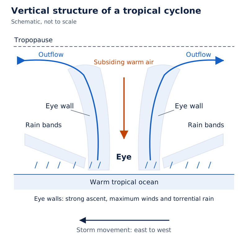
The central eye is beneath arrows labelled subsiding warm air. Eye walls flank it, rain bands slope outwards, and upper arrows show outflow. The tropopause and direction of storm movement are labelled.
Drawn by One Young India. See Fig. 9.10 in your NCERT textbook
Case study: What dimensions describe storms over the Indian Ocean region?
Over the Bay of Bengal, Arabian Sea and Indian Ocean, storm diameter lies between 600 and 1,200 km. The system moves slowly, about 300 to 500 km per day. Storm surges inundate, or flood, coastal lowlands, and the storm peters out over land.
| Quantity | Value | What the value describes |
|---|---|---|
| Circulating-system diameter | Can vary between 150 and 250 km | The circulating system in the mature-cyclone description |
| Maximum wind velocity | As high as 250 km per hour | Wind in the eye wall |
| Regional storm diameter | 600 to 1,200 km | Storms over the Bay of Bengal, Arabian Sea and Indian Ocean |
| Movement of the system | About 300 to 500 km per day | Travel of the storm as a whole |
The circulating-system diameter and regional storm diameter are separately described quantities. Keep these quantities distinct from the eye diameter, the width of the central calm region. The velocity of wind within the eye wall is also different from the rate at which the whole storm moves.
Regional names include cyclones in the Indian Ocean, hurricanes in the Atlantic, typhoons in the western Pacific and South China Sea, and willy-willies in Western Australia. These names refer here to tropical cyclones in different regions.
How do thunderstorms and tornadoes develop?
Thunderstorms and tornadoes are violent local storms of short duration affecting small areas. A thunderstorm is a well-grown cumulonimbus cloud producing thunder and lightning. Intense convection on hot, moist days causes its development.
What happens inside a thunderstorm?
- An intense updraft, or rising current of warm air, causes the cloud to grow larger and extend upwards.
- As the cloud develops to greater height, precipitation occurs.
- If it reaches levels with sub-zero temperatures, meaning temperatures below 0°C, hail forms and falls as a hailstorm. Hail is precipitation in pieces of ice.
- Later, a downdraft, or descending air current, brings cool air and rain to the ground.
If moisture is insufficient, a thunderstorm can generate a dust storm. Thus, the moisture available affects the storm's visible effects. Hail formation depends on the cloud extending into sufficiently cold levels, rather than being a feature of every thunderstorm.
How is a tornado related to a thunderstorm?
From severe thunderstorms, spiralling wind sometimes descends with great force, resembling an elephant's trunk. Very low pressure occurs at its centre, and it can cause massive destruction along its path. This phenomenon is a tornado.
Tornadoes generally occur in middle latitudes. A tornado over the sea is called a waterspout. The terms distinguish the setting, while the connection with severe thunderstorms explains the origin described here.
These storms express atmospheric adjustment to unequal energy distribution. Potential energy, energy associated with position, and heat energy are converted into kinetic energy, the energy of motion. The restless atmosphere then returns to a stable state.
Glossary
- Atmospheric pressure — Weight of an air column over a unit area from mean sea level to the atmosphere's top.
- Isobar — A line joining places that have equal atmospheric pressure at a common level.
- Pressure gradient — The rate of change of atmospheric pressure with respect to distance.
- Coriolis force — The effect of the earth's rotation that deflects wind right or left according to hemisphere.
- Geostrophic wind — Wind parallel to straight isobars when friction is absent and pressure gradient and Coriolis forces balance.
- ITCZ — Inter Tropical Convergence Zone, the low-pressure zone where winds from the tropics converge and air rises.
- Hadley cell — Tropical circulation linking rising equatorial air, upper poleward flow, subtropical sinking and surface easterlies.
- ENSO — The combined phenomenon of El Nino and the southern oscillation in Pacific pressure conditions.
- Katabatic wind — Cool air draining from high plateaus and ice fields into a valley.
- Air mass — A large body of air having little horizontal variation in temperature and moisture.
- Front — The boundary zone formed where two different air masses meet.
- Occluded front — A front associated with an air mass fully lifted above the land surface.
- Landfall — The place where a tropical cyclone crosses the coast as it moves onto land.
- Eye wall — The region surrounding a cyclone's eye where strong spiralling ascent, maximum winds and torrential rain occur.
- Tornado — A violently descending spiralling wind from a severe thunderstorm, with very low central pressure.
Common errors and misconceptions
- Misconception: Pressure decreases at exactly the same rate at all heights. Correct: About 1 mb per 10 m is a lower-atmosphere description; the rate does not always remain the same.
- Misconception: A large vertical pressure gradient necessarily produces strong upward winds. Correct: Its force is generally balanced by a nearly equal, opposite gravitational force.
- Misconception: Coriolis deflection is strongest at the equator. Correct: The Coriolis force is absent there and maximum at the poles.
- Misconception: All winds blow straight across isobars. Correct: Geostrophic wind flows parallel to straight isobars when friction is absent and the two controlling forces balance.
- Misconception: Land breeze blows from sea to land during the day. Correct: That is sea breeze; land breeze blows from land towards sea at night.
- Misconception: Every strong ENSO episode must cause drought in India. Correct: Drought occurs sometimes in India during years of strong ENSO.
- Misconception: The eye contains a tropical cyclone's fiercest winds and rain. Correct: The eye is calm with sinking air; maximum winds and torrential rain occur in the eye wall.
- Misconception: Every severe thunderstorm produces a tornado. Correct: Tornadoes descend from severe thunderstorms sometimes, and they generally occur in middle latitudes.
Exam-style questions with model answers
Q1. Surface pressure is 1,000 mb, where mb means millibar. Assume pressure decreases by 1 mb per 10 metres. Using 1 kilometre = 1,000 metres, estimate the pressure 1 kilometre above the surface. Show the decrease and final pressure. [2 marks]
- The height increase is 1,000 metres. The assumed pressure decrease is therefore 1,000 ÷ 10 = 100 millibars.
- The estimated pressure is surface pressure minus this decrease: 1,000 − 100 = 900 millibars. This uses the stated approximate decrease.
Q2. Define an isobar and explain why station pressure is reduced to sea level for a weather map. [2 marks]
- An isobar joins places with equal atmospheric pressure at a common level.
- Reducing station pressure to sea level removes the effect of altitude, allowing pressure readings from stations at different elevations to be compared.
Q3. Explain how the pressure gradient force, frictional force and Coriolis force affect wind near the earth's surface. Give one separate point for each force. [3 marks]
- The pressure gradient force results from pressure differences and sets air in motion. Close isobars indicate a stronger gradient, while widely separated isobars indicate a weaker one.
- Friction affects wind speed and is greatest at the surface. Its influence generally extends to 1 to 3 kilometres, and it is minimal over the sea.
- The Coriolis force deflects wind right in the northern hemisphere and left in the southern hemisphere. It is absent at the equator and maximum at the poles.
Q4. Explain sea breeze and land breeze through four points covering daytime heating, daytime pressure and wind, night-time cooling, and night-time pressure and wind. [4 marks]
- During the day, land heats faster than the sea and becomes warmer. Air over the land rises in response to this heating.
- Low pressure develops over land, while pressure over the relatively cool sea is higher. Wind blows from sea towards land as a sea breeze.
- At night, land loses heat faster than the sea and becomes cooler. The daytime contrast between the two surfaces is reversed.
- The pressure gradient is then directed from land towards sea. Wind follows this gradient from land to sea, producing a land breeze.
Q5. Describe extra tropical cyclone development in the northern hemisphere in five stages, from the initial polar front to occlusion and dissipation. [5 marks]
- The polar front is initially stationary. Warm air blows from the south and cold air from the north on opposite sides of the front.
- When pressure drops along it, warm air moves northwards and cold air southwards. This movement establishes an anticlockwise cyclonic circulation in the northern hemisphere.
- The developed cyclone has warm and cold fronts, with a warm sector between cold air. Warm air glides over cold air ahead of the warm front, producing clouds and precipitation.
- The cold front approaches from behind and pushes warm air upwards. Cumulus clouds develop along it, and the cold front moves faster than the warm front.
- The cold front overtakes the warm front and lifts the warm air completely above the surface. The front becomes occluded, and the cyclone dissipates.
Q6. State all five conditions favourable for tropical cyclone formation and intensification, then explain why the storm weakens after reaching land. Give six separate points. [6 marks]
- A large sea surface with a temperature higher than 27 degrees Celsius favours formation and intensification. The favourable setting is a warm tropical ocean.
- The presence of the Coriolis force favours development. Its absence at the equator explains why tropical cyclones do not form near the equator.
- Variations in vertical wind speed should be small. This condition concerns differences in wind speed at different heights above the surface.
- A weak low-pressure area or low-level cyclonic circulation should already exist. This supplies the pre-existing low-pressure setting included among the favourable conditions.
- Upper divergence above the sea level system favours development. Divergence means air spreading apart in the upper part of the atmospheric circulation.
- After landfall, the supply of moisture from the sea is cut off. The storm loses the continuing moisture supply that strengthened it and dissipates.
Q7. Define ENSO and state its associated weather effects in South America, Australia, India and China during strong ENSO years. Organise the answer into three points and retain the qualification for India. [3 marks]
- ENSO combines El Nino, the appearance of warm water off Peru, with the southern oscillation, the associated change in Pacific pressure conditions involving the central Pacific and Australia.
- In strong ENSO years, the arid western coast of South America receives heavy rainfall, while drought occurs in Australia. These are contrasting regional weather effects.
- Drought occurs sometimes in India, while China experiences floods. The qualification “sometimes” must remain part of the Indian effect rather than making drought an inevitable result.
Q8. Distinguish a tropical cyclone's eye from its eye wall using air movement, wind conditions and rainfall. Give one point for each region. [2 marks]
- The eye is the central calm region of the cyclone, with subsiding air, light winds and little or no rainfall.
- The eye wall surrounds the eye and has strong spiralling ascent. Maximum wind velocity and torrential rainfall occur in this surrounding region.
Key takeaways
- Pressure decreases with altitude, but its rate of decrease varies; the vertical pressure gradient force is generally balanced by gravity.
- Isobars connect equal pressure, while their spacing indicates gradient strength; pressure belts shift with the sun's apparent movement.
- Pressure gradient, friction and Coriolis forces jointly control surface winds; geostrophic wind requires straight isobars and the absence of friction.
- Hadley, Ferrel and polar cells establish general circulation, maintained by heat transfer from lower towards higher latitudes.
- Ocean and atmospheric circulation interact; strong ENSO brings widespread weather variations, with drought occurring sometimes in India.
- Local heating contrasts produce land, sea, valley and mountain winds; prolonged residence over a source region gives air masses distinctive characteristics.
- Extra tropical cyclones have clear fronts; tropical cyclones draw strength from warm seas and lose moisture supply after reaching land.
- Tropical cyclone eyes are calm, eye walls carry maximum winds and torrential rain, and tornadoes sometimes descend from severe thunderstorms.
Test yourself
Which instruments measure atmospheric pressure?
A mercury barometer or an aneroid barometer measures atmospheric pressure.
What does closely spaced isobar coverage indicate?
Closely spaced isobars indicate a strong pressure gradient over the mapped area.
Why does tropical cyclone formation not occur near the equator?
The Coriolis force is absent at the equator. Wind fills the low-pressure area instead of allowing it to intensify.
What are the two reasons for air sinking near 30° N and 30° S?
Air accumulates after moving polewards from the upper tropical atmosphere, and it also cools at these latitudes. Part of the accumulated air sinks.
How do a cold front and a warm front differ?
At a cold front, cold air advances towards warm air. At a warm front, warm air advances towards cold air.
What is landfall, and why does a tropical cyclone dissipate over land?
Landfall is the place where the cyclone crosses the coast. Over land, its supply of moisture from the sea is cut off.
Where do a mature tropical cyclone's maximum winds and torrential rain occur?
They occur in the eye wall, where air spirals strongly upwards around the calm eye.
What is a waterspout?
A waterspout is the name given to a tornado occurring over the sea.
Write about it
Turn a question from this chapter into a paper.
The Writing Studio has a structure guide, a rubric and citation tools for 15 formats, from essays to research papers. Drafting is free with an account. Learnacy Essential adds feedback from an AI writing coach and submission to The OYI Review.
Publication depends on review and is not guaranteed.