
Natural Vegetation | CBSE Class 11 Geography Notes
On this page

This note covers natural vegetation, the distribution and characteristics of Indian forests, mountain vegetation, wetlands and mangroves, forest conservation, social forestry, wildlife protection, species conservation projects and biosphere reserves.
What is natural vegetation, and why does it vary across India?
Definition: Natural vegetation is a plant community left undisturbed over a long time, allowing its individual species to adjust to climate and soil conditions as fully as possible.
The distinction between natural vegetation and planted vegetation concerns how plants grow. The same variety may grow wild in a forest under natural conditions and may also be planted in a garden under human supervision.
India has great regional variety. Himalayan heights have temperate vegetation, associated with cooler conditions. The Western Ghats and the Andaman and Nicobar Islands have tropical rain forests, associated with the warm regions between the tropics. Deltaic regions, near river mouths, have tropical forests and mangroves, which are coastal forests containing salt-tolerant plants.
Desert and semi-desert areas of Rajasthan have cacti, bushes and thorny vegetation. Changes in climate and soil therefore help explain changes in vegetation from one region to another.
How are the forest groups organised?
Predominant vegetation and climatic regions provide the basis for five groups: tropical evergreen and semi evergreen forests; tropical deciduous forests; tropical thorn forests; montane, or mountain, forests; and littoral and swamp forests, associated with coasts and wetlands.
What the figure shows
Natural Vegetation
The map uses five legend patterns for these forest groups. Dots mark montane forest along the northern mountain belt; broad shaded areas represent deciduous forests; small black coastal patches represent littoral and swamp forest.
See Fig. 5.2 in your NCERT textbook
Read the map by matching each pattern to its legend. The categories distinguish large vegetation regions; the following comparisons explain their rainfall conditions, plant composition and geographical distribution.
What distinguishes tropical evergreen and semi evergreen forests?
Where do evergreen forests develop?
Tropical evergreen forests appear green throughout the year. They occur on the western slope of the Western Ghats, in the hills of the northeastern region, and in the Andaman and Nicobar Islands.
Their conditions are warm and humid, meaning that the air contains much moisture, with annual precipitation, meaning water received from the atmosphere, of over 200 centimetres and a mean annual temperature above 22 degrees Celsius. The mean is the average for the year.
These forests are well stratified, meaning arranged in layers. Shrubs and creepers occupy layers close to the ground. Short trees are followed by taller varieties, with trees reaching heights up to 60 metres or above.
There is no definite time for trees to shed leaves, flower or bear fruit. This explains their green appearance all year round. Rosewood, mahogany, aini and ebony are examples of their tree species.
Photograph: Evergreen Forest (NCERT Class 11 Figure 5.1). The photograph shows a dense cover of leafy tree crowns at different heights. It is a photograph of forest vegetation, rather than a labelled drawing of individual species.
How are semi evergreen forests different?
Semi evergreen forests occur in the less rainy parts of these regions. They contain a mixture of evergreen and moist deciduous trees, the latter belonging to forests with seasonal leaf shedding. Undergrowing climbers give the forests an evergreen character.
White cedar, hollock and kail are the main species. The distinction concerns both moisture conditions and forest composition: semi evergreen forests combine tree types, while their climbers contribute to the continuing green appearance.
How do deciduous and thorn forests differ?
Tropical deciduous forests, also called monsoon forests, are India's most widespread forests. They occupy regions receiving 70 to 200 centimetres of rainfall. Availability of water separates them into moist and dry deciduous forests.
Which rainfall ranges distinguish the types?
| Forest type | Rainfall condition | Representative species |
|---|---|---|
| Tropical evergreen | Over 200 centimetres annually | Rosewood, mahogany, aini, ebony |
| Moist deciduous | 100 to 200 centimetres | Teak, sal, shisham, sandalwood |
| Dry deciduous | 70 to 100 centimetres | Tendu, palas, amaltas, bel |
| Tropical thorn | Less than 50 centimetres | Babool, ber, wild date palm, khejri |
Moist deciduous forests are more pronounced where rainfall is 100 to 200 centimetres. They occur in northeastern states along the Himalayan foothills, on the eastern slopes of the Western Ghats and in Odisha. Other main species include hurra, mahua, amla, semul and kusum.
Dry deciduous forests occupy rainier areas of the Peninsula and the plains of Uttar Pradesh and Bihar. Their wetter margins pass into moist deciduous forests, while their drier margins pass into thorn forests.
In higher-rainfall parts of the Peninsular plateau and northern Indian plain, their parkland landscape has open stretches of teak and other trees interspersed with grass. As the dry season begins, trees shed their leaves completely, creating a grassland-like appearance with bare trees.
Khair and axlewood are also common dry deciduous trees. In western and southern Rajasthan, low rainfall and overgrazing make vegetation cover very scanty.
What gives thorn forests their appearance?
Tropical thorn forests contain grasses and shrubs in areas with less than 50 centimetres of rainfall. They occur in semi-arid, or relatively dry, areas of southwest Punjab, Haryana, Rajasthan, Gujarat, Madhya Pradesh and Uttar Pradesh.
Plants remain leafless for most part of the year, producing a scrub appearance dominated by low woody vegetation. Besides the species in the table, khair, neem and palas occur. Tussocky grass, growing in clumps, forms undergrowth up to 2 metres high.
Photograph: Deciduous Forests and Tropical Thorn Forests (NCERT Class 11 Figures 5.3 and 5.4). The deciduous forest photograph shows tall trunks beneath leafy cover. The thorn forest photograph shows low, spreading scrub across the foreground, with open ground beyond it.
How does vegetation change with altitude in mountain regions?
In mountains, altitude, or height above sea level, influences vegetation. Temperature decreases as altitude increases, and natural vegetation changes correspondingly. Mountain forests fall into northern and southern groups.
What is the Himalayan sequence?
The Himalayas show a succession from tropical vegetation to tundra vegetation, represented at higher altitudes by mosses and lichens. The following sequence connects increasing altitude with changing vegetation rather than treating all mountain forests as one type.
- Deciduous forests occur in the Himalayan foothills. Above them, wet temperate forests occur between 1,000 and 2,000 metres.
- Evergreen broad-leaved oak and chestnut predominate in the higher northeastern hills and hilly areas of West Bengal and Uttaranchal. Pine forests are also well developed between 1,500 and 1,750 metres.
- Blue pine and spruce appear between 2,225 and 3,048 metres. Temperate grasslands are also found at many places in this zone.
- Higher reaches pass into Alpine forests and pastures, the high-mountain forest and grazing zone. Silver firs, junipers, pines, birch and rhododendrons occur between 3,000 and 4,000 metres.
- At higher altitudes, mosses and lichens form part of tundra vegetation.
Chir pine has commercial importance. Deodar grows mainly in the western Himalayan range, and its durable wood is mainly used in construction. Chinar and walnut support Kashmir handicrafts.
Gujjars, Bakarwals, Bhotiyas and Gaddis extensively use the high pastures for transhumance, the seasonal movement of people with livestock between pastures. Southern Himalayan slopes carry thicker vegetation because precipitation is relatively higher than on the drier north-facing slopes.
Where are the southern mountain forests?
The southern group includes the Western Ghats, Vindhyas and Nilgiris. These areas are closer to the tropics and only 1,500 metres above sea level. Higher regions have temperate vegetation, while lower Western Ghats regions have subtropical vegetation, associated with conditions between tropical and temperate climates, especially in Kerala, Tamil Nadu and Karnataka.
Sholas are temperate forests in the Nilgiri, Anaimalai and Palani hills. Economically significant trees include magnolia, laurel, cinchona and wattle. Such forests also occur in the Satpura and Maikal ranges.
Photograph: Montane Forests (NCERT Class 11 Figure 5.5). The photograph shows trees covering sloping mountain ground, with a more open strip in the foreground. Tree cover follows the uneven relief.
Where are India's wetlands and mangrove forests found?
Wetlands are habitats associated with waterlogged or water-covered ground. India has a rich variety, with a total area of 3.9 million hectares. About 70 per cent comprises areas under paddy cultivation. A hectare is a unit of land area.
Chilika Lake in Odisha and Keoladeo National Park at Bharatpur are protected as water-fowl habitats, meaning habitats for water birds, under the Ramsar Convention, the Convention of Wetlands of International Importance. An international convention is an agreement among member states of the United Nations.
What are the eight wetland categories?
- Reservoirs of the southern Deccan Plateau, together with lagoons and other wetlands of the southern west coast. Reservoirs store water; lagoons are coastal water bodies separated from the sea by a barrier.
- Vast saline, or salty, expanses of Rajasthan, Gujarat and the Gulf of Kachchh.
- Freshwater lakes and reservoirs extending from Gujarat eastwards through Rajasthan, including Keoladeo National Park, and Madhya Pradesh.
- Delta wetlands and lagoons of the east coast, including Chilika Lake.
- Freshwater marshes, or waterlogged wetlands, of the Gangetic Plain.
- Brahmaputra floodplains, the low ground flooded by the river; marshes and swamps in northeastern hills and Himalayan foothills.
- Lakes and rivers of the mountain region of Kashmir and Ladakh.
- Mangrove forests and other wetlands of the Andaman and Nicobar island arcs.
What characterises mangrove habitats?
Mangroves grow in coastal salt marshes, tidal creeks, mud flats and estuaries. Tidal creeks are channels affected by tides; mud flats are muddy coastal surfaces; estuaries are river-mouth areas where river water meets seawater. Mangrove plants include a number of salt-tolerant species.
Creeks with stagnant water and tidal flows crisscross these forests, which shelter many kinds of birds. Indian mangroves cover 4,992 square kilometres, amounting to 7 per cent of the world's mangrove forests.
They are highly developed in the Andaman and Nicobar Islands and the Sunderbans of West Bengal. The Mahanadi, Godavari and Krishna deltas are other important areas. Encroachment on these forests makes conservation necessary.
Photograph: Mangrove Forests (NCERT Class 11 Figure 5.6). Dense leafy vegetation stands above a visible network of exposed, branching roots and stems. The photograph illustrates the physical appearance of a mangrove stand.
Case study: How did British commercial use alter Indian forests?
The British recognised the economic value of Indian forests and began large-scale exploitation. Commercial use affected the structure of forests as well as the land they occupied. Protective uses gave way to commercial demands.
Which changes show this shift?
In Garhwal and Kumaon, oak forests were replaced by pine, or chirs, needed for railway lines. This was a change in the kinds of trees making up the forest, rather than simply the removal of timber from an unchanged forest.
Forests were also cleared to introduce tea, rubber and coffee plantations. These plantations were established for commercial purposes. Clearing forest for plantation land changed its use and placed vegetation under human management.
Timber was used in construction because wood acts as an insulator of heat, meaning that it restricts heat transfer. Railways, plantation development and building activities therefore illustrate different commercial demands on forests.
The example connects human activity with vegetation change. Climate and soil help explain natural forest differences, while replacement of trees and clearing for plantations show how people can alter forest composition and land use.
Why is forest conservation necessary, and what does forest policy seek?
Forest conservation means protecting and managing forests. Forests have intricate relationships with life and the environment and provide direct and indirect advantages to the economy and society. Their conservation is vital to human survival and prosperity.
India adopted a forest policy in 1952 and modified it in 1988. The later policy emphasises sustainable forest management: conserving and expanding forest reserves while also meeting local people's needs.
What are the policy aims?
- Bring 33 per cent of the geographical area under forest cover, meaning land covered by forest vegetation.
- Maintain environmental stability and restore forests where ecological balance, the stability of relationships within the environment, has been disturbed.
- Conserve natural heritage, biological diversity, meaning the variety of living organisms, and the genetic pool, meaning their inherited genetic variety.
- Check soil erosion, the removal of soil, and the extension of desert lands, and reduce floods and droughts.
- Increase forest cover through social forestry and afforestation, or establishing tree cover, on degraded land.
- Raise forest productivity to supply timber, fuel, fodder and food to forest-dependent rural people, and encourage substitutes for wood. Fodder means feed for livestock.
- Create a massive people's movement involving women to encourage planting, stop tree felling and reduce pressure on existing forests.
How are forests linked to tribal livelihoods?
For a vast number of tribal people, forests provide homes and livelihoods. They supply fruits, edible leaves, honey, nourishing roots and wild game, together with materials for houses and artistic work. It is commonly believed that tribal communities live in harmony with nature and protect forests.
Tribal knowledge of forestry can support forest development. Communities should be encouraged to participate in conservation and become growers of minor forest produce, meaning non-timber forest products, rather than being treated merely as collectors.
How do social forestry and farm forestry involve people?
Definition: Social forestry is the management and protection of forests and afforestation on barren land to support environmental, social and rural development.
The National Commission on Agriculture classified social forestry into urban forestry, rural forestry and farm forestry in 1976. These categories connect tree growing with different land settings and the people who use them.
How do urban and rural forestry differ?
Urban forestry raises and manages trees on public and private land in and around urban centres. It includes green belts, parks, roadside avenues and industrial and commercial green belts, which are areas planted with vegetation.
Rural forestry promotes agro-forestry and community forestry. Agro-forestry raises trees and agricultural crops on the same land, including waste patches. It combines forestry and agriculture to produce food, fodder, fuel, timber and fruit.
Community forestry raises trees on public or community land. Examples include village pastures, temple land, roadsides, canal banks, railway strips and school grounds. Its benefits are intended for the community as a whole.
This provides a way for landless people to participate in tree raising and obtain benefits otherwise restricted to landowners. The ownership and use of land therefore matter when distinguishing community forestry from tree growing on an individual farm.
What is farm forestry?
Farm forestry is the growing of trees by farmers on their farmland for commercial and non-commercial purposes. Forest departments in various states distribute tree seedlings free of cost to small and medium farmers.
| Approach | Land or setting | Defining feature |
|---|---|---|
| Urban forestry | Public and private urban land | Raising and managing trees in and around towns |
| Agro-forestry | Land carrying crops and trees | Combines agriculture and forestry |
| Community forestry | Public or community land | Benefits the whole community, including landless people |
| Farm forestry | Farmers' land | Commercial and non-commercial tree growing |
Non-commercial farm forestry can use field margins, grasslands, pastures and land around homes and cattle sheds. These locations show how tree raising can become part of rural land use beyond a separate forest area.
Why has wildlife declined, and how is it protected?
Wildlife refers to animals and other living organisms in their natural surroundings. It is estimated that about 4 to 5 per cent of all known plant and animal species on Earth occur in India.
The main reason for this diversity is the variety of ecosystems, meaning systems of living organisms and their environment, preserved and supported through the ages. Human disturbance of habitats, the places where organisms live, has significantly reduced wildlife numbers. Certain species are at the brink of extinction.
What pressures damage wildlife and its habitat?
- Industrial and technological advancement rapidly increased exploitation of forest resources.
- Land was cleared for farming, human settlements, roads, mining and reservoirs.
- Lopping, or cutting branches, for fodder and fuelwood and removal of small timber increased forest pressure.
- Grazing by domestic cattle adversely affected wildlife and its habitat.
- Elite sport hunting killed hundreds of animals in a single hunt; commercial poaching, or illegal hunting, is rampant.
- Forest fires also contributed to wildlife decline.
What protection framework was introduced?
The Wildlife Act of 1972 provided a comprehensive legal framework. Its two principal objectives were to protect endangered species listed in its schedule, meaning its formal list, and support conservation areas classified as national parks, sanctuaries and closed areas.
The Act was comprehensively amended in 1991. Punishments became more stringent, with provisions to protect specified plant species and conserve endangered wild animals. Endangered species are those facing the danger of extinction.
The protected-area figures are 107 national parks and 573 wildlife sanctuaries. Wildlife conservation also depends on individuals understanding its significance and contributing to it. Conservation of plants and animals includes collaboration with the Man and Biosphere Programme.
Photograph: Elephants in their Natural Habitat (NCERT Class 11 Figure 5.7). Several elephants stand together in the foreground of an open grassy area. More elephants are visible farther back, with trees beyond them.
Case study: What do Project Tiger and Project Elephant conserve?
Project Tiger and Project Elephant conserve the named animals and their habitats in a sustainable manner. Protecting a population involves attention to the places in which it can continue living, alongside the animals themselves.
How has Project Tiger developed?
Implemented since 1973, Project Tiger aims to maintain a viable tiger population, meaning a population capable of continuing to survive. Its purposes include scientific, aesthetic, cultural and ecological values, relating to knowledge, beauty, culture and environmental relationships.
It also seeks to preserve biologically important areas as natural heritage for people's benefit, education and enjoyment. The programme began in nine tiger reserves covering 16,339 square kilometres.
| Indicator | Earlier figure | Later figure |
|---|---|---|
| Tiger reserves | 9 at the launch | 58 |
| Area | 16,339 square kilometres at the launch | 84,487 square kilometres of core tiger habitats, the central habitat areas |
| Tiger population | 1,411 in 2006 | 3,682 in 2023 |
The later reserve network extends across 18 states. The population of 3,682 in 2023 represents more than 75 per cent of the global tiger population. Core tiger habitats are the central habitat areas within the reserve network.
What does Project Elephant aim to do?
Launched in 1992, Project Elephant assists states with free-ranging wild elephant populations, meaning elephants living and moving in natural surroundings. It aims at the long-term survival of identified viable populations in their natural habitats and is implemented in 18 states.
Other initiatives include the Crocodile Breeding Project, Project Hangul and conservation of Himalayan musk deer. These examples show that species-focused protection forms part of the wider wildlife conservation effort.
Note: Keep the two project dates distinct: Project Tiger began in 1973 and Project Elephant in 1992. The tiger population comparison uses the separate observation years 2006 and 2023.
What are biosphere reserves, and how do their objectives fit together?
Definition: A biosphere reserve is a unique, representative ecosystem of terrestrial and coastal areas, internationally recognised within the Man and Biosphere Programme. Terrestrial means land-based.
The programme belongs to UNESCO, the United Nations Educational, Scientific and Cultural Organization. Its abbreviation MAB means Man and Biosphere. India has 18 biosphere reserves, of which twelve have recognition in UNESCO's World Network of Biosphere Reserves.
What are the three objectives?
- Conservation: conservation of biodiversity and the ecosystem. Biodiversity is the variety of living organisms.
- Development: association of the environment with development.
- Logistics: an international network for research and monitoring, meaning systematic observation of conditions and changes.
What the figure shows
Objectives of a Biosphere Reserve
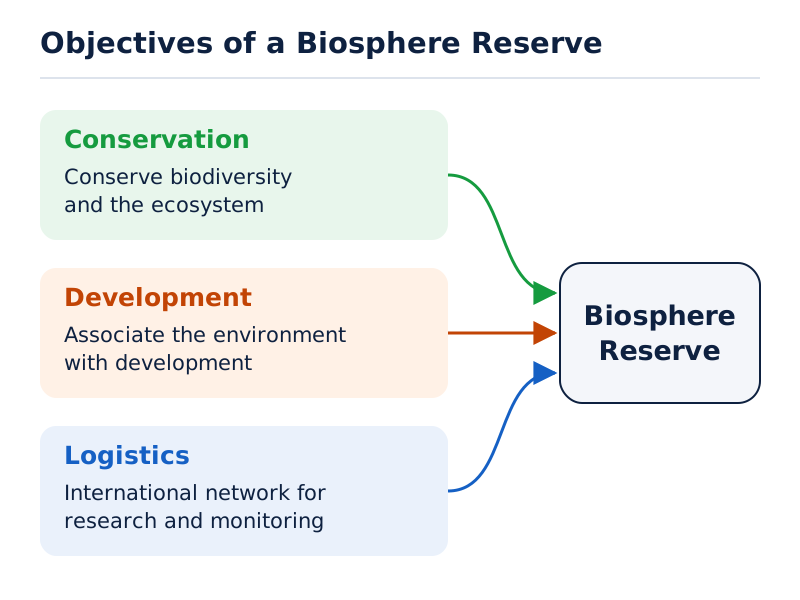
Boxes headed Conservation and Development have arrows pointing towards a central Biosphere Reserve box. A broad Logistics shape below carries the words “International network for research and monitoring”.
Drawn by One Young India. See Fig. 5.9 in your NCERT textbook
Which reserves occur in which states?
| Biosphere reserve | Year of designation | State or territory |
|---|---|---|
| Nilgiri | 1986 | Tamil Nadu, Kerala and Karnataka |
| Nanda Devi | 1988 | Uttarakhand |
| Nokrek | 1988 | Meghalaya |
| Manas | 1989 | Assam |
| Sunderban | 1989 | West Bengal |
| Gulf of Mannar | 1989 | Tamil Nadu |
| Great Nicobar | 1989 | Andaman and Nicobar Islands |
| Similipal | 1994 | Odisha |
| Dibru-Saikhowa | 1997 | Assam |
| Dehang Debang | 1998 | Arunachal Pradesh |
| Pachmarhi | 1999 | Madhya Pradesh |
| Khangchendzonga | 2000 | Sikkim |
| Agasthyamalai | 2001 | Tamil Nadu and Kerala |
| Achanakmar-Amarkantak | 2005 | Madhya Pradesh and Chhattisgarh |
| Kachchh | 2008 | Gujarat |
| Cold Desert | 2009 | Himachal Pradesh |
| Seshachalam | 2010 | Andhra Pradesh |
| Panna | 2011 | Madhya Pradesh |
What the figure shows
India: Biosphere Reserves
Labelled dots locate reserves including Nanda Devi in the north, Nilgiri and Gulf of Mannar in the south, Sunderbans in the east and Great Nicobar on the southeastern island chain. The map includes a north arrow and distance scale.
See Fig. 5.8 in your NCERT textbook
For location practice, connect Nanda Devi with Uttarakhand, Sunderban with West Bengal, Gulf of Mannar with Tamil Nadu, and Nilgiri with Tamil Nadu, Kerala and Karnataka. Designation years identify when each reserve received that designation; they are distinct from the dates of species conservation projects.
Glossary
- Natural vegetation — A plant community left undisturbed long enough to adjust as fully as possible to climate and soil.
- Tropical evergreen forests — Warm, humid forests appearing green throughout the year without a definite time for leaf shedding.
- Semi evergreen forests — Forests of less rainy regions combining evergreen and moist deciduous trees with undergrowing climbers.
- Moist deciduous forests — Monsoon forests more pronounced in regions receiving rainfall between 100 and 200 centimetres.
- Dry deciduous forests — Forests receiving 70 to 100 centimetres of rainfall, whose trees shed leaves completely as the dry season begins.
- Tropical thorn forests — Grassy and shrubby forests in areas receiving less than 50 centimetres of rainfall.
- Sholas — Temperate forests found in the Nilgiri, Anaimalai and Palani hills of southern India.
- Mangroves — Coastal forests containing salt-tolerant plants in salt marshes, tidal creeks, mud flats and estuaries.
- Social forestry — Forest management, protection and afforestation on barren lands to support environmental, social and rural development.
- Agro-forestry — Raising trees and agricultural crops together on the same land, including its waste patches.
- Community forestry — Raising trees on public or community land to provide benefits to the community as a whole.
- Farm forestry — Farmers growing trees on their own farmland for commercial and non-commercial purposes.
- Biosphere reserve — A representative terrestrial and coastal ecosystem internationally recognised within UNESCO's Man and Biosphere Programme.
Common errors and misconceptions
- Misconception: Every tree growing in India is natural vegetation. Correct: Natural vegetation has developed undisturbed over time; the same variety may instead be planted under human supervision.
- Misconception: Evergreen trees never shed leaves. Correct: There is no definite time for leaf shedding, flowering and fruiting, so the forest appears green throughout the year.
- Misconception: Moist and dry deciduous forests have identical rainfall conditions. Correct: Their rainfall ranges are 100 to 200 and 70 to 100 centimetres respectively.
- Misconception: Thorn forest plants remain leafless throughout the year. Correct: They remain leafless for most part of the year.
- Misconception: Mountain vegetation stays unchanged with height. Correct: Falling temperature with increasing altitude produces a corresponding vegetation change.
- Misconception: Community forestry benefits landowners alone. Correct: It benefits the whole community and allows landless people to participate in tree raising.
- Misconception: The forest policy's 33 per cent figure describes an achieved result. Correct: It is the target for bringing geographical area under forest cover.
- Misconception: All eighteen biosphere reserves have World Network recognition. Correct: The total is eighteen, while twelve have that recognition.
Exam-style questions with model answers
Q1. A forest has no definite time for leaf shedding, flowering or fruiting, and appears green all year. Identify its forest type and explain its appearance using the given information. [2 marks]
- It is a tropical evergreen forest, characterised by its green appearance throughout the year.
- There is no definite time for leaf shedding, flowering or fruiting, so its overall green appearance continues through the year.
Q2. Moist deciduous forests receive 100 to 200 centimetres of rainfall; dry deciduous forests receive 70 to 100 centimetres; thorn forests receive less than 50 centimetres. Distinguish the three forest types by their rainfall conditions. [3 marks]
- Moist deciduous forests occupy the wetter range in this comparison, receiving between 100 and 200 centimetres of rainfall.
- Dry deciduous forests receive between 70 and 100 centimetres of rainfall, below the range given for moist deciduous forests.
- Tropical thorn forests occur in areas receiving less than 50 centimetres of rainfall, the driest conditions among these three types.
Q3. Himalayan foothills have deciduous forests; wet temperate forests occur at 1,000 to 2,000 metres; blue pine and spruce appear at 2,225 to 3,048 metres; silver firs, junipers, pines, birch and rhododendrons occur at 3,000 to 4,000 metres. Describe the vegetation sequence in four points. [4 marks]
- Begin at the Himalayan foothills, where deciduous forests form the lowest part of the supplied vegetation sequence.
- At altitudes between 1,000 and 2,000 metres, the sequence passes into wet temperate forests above the foothill forests.
- At greater heights, between 2,225 and 3,048 metres, blue pine and spruce appear as the named trees.
- Between 3,000 and 4,000 metres, the vegetation includes silver firs, junipers, pines, birch and rhododendrons.
Q4. Urban forestry manages trees on urban public and private land. Agro-forestry combines trees and crops on the same land. Community forestry raises trees on common land for collective benefit, including landless people. Farm forestry grows trees on farms for commercial and non-commercial purposes. Explain these four approaches. [4 marks]
- Urban forestry concerns raising and managing trees in urban settings, using both publicly owned land and privately owned land.
- Agro-forestry integrates tree growing with crop cultivation on the same land, bringing forestry and agriculture together in one land use.
- Community forestry uses common land to provide collective benefits, allowing landless people to participate in growing trees and sharing benefits.
- Farm forestry involves farmers growing trees on their farms, with purposes that may be commercial or non-commercial.
Q5. Forest policy seeks 33 per cent forest cover, environmental stability and restoration, protection of natural heritage and biological diversity, control of erosion and desert spread with fewer floods and droughts, and a people's movement involving women to plant trees, stop felling and reduce pressure on existing forests. Explain these five aims. [5 marks]
- The policy aims to bring 33 per cent of the country's geographical area under forest cover. This is a target for forest conservation.
- It seeks environmental stability and forest restoration where ecological balance has been disturbed, linking protection with the recovery of damaged forests.
- It aims to conserve natural heritage and biological diversity, so the variety of living organisms is included within forest conservation.
- It seeks to check soil erosion and desert expansion while reducing floods and droughts, connecting forests with wider environmental protection.
- It encourages a large people's movement involving women, promoting tree planting and stopping felling to reduce pressure on existing forests.
Q6. Project Tiger began in 1973 to maintain viable tiger populations, capable of continuing to survive, and preserve biologically important areas as natural heritage for public benefit, education and enjoyment. It began with 9 reserves covering 16,339 square kilometres; the later figures are 58 reserves and 84,487 square kilometres of core tiger habitats in 18 states. Tiger numbers rose from 1,411 in 2006 to 3,682 in 2023, more than 75 per cent of the global population. Explain its purpose and development in five points. [5 marks]
- Project Tiger began in 1973 to maintain viable populations of tigers. A viable population is one capable of continuing to survive.
- Its purpose includes preserving areas of biological importance as natural heritage, connecting tiger conservation with people's benefit, education and enjoyment.
- The programme expanded from nine tiger reserves at its launch to fifty-eight reserves in the later figures, distributed across eighteen states.
- The initial area was 16,339 square kilometres, while the later area figure is 84,487 square kilometres of core tiger habitats.
- Tiger numbers increased from 1,411 in 2006 to 3,682 in 2023. The latter population represents more than 75 per cent of the global total.
Q7. A biosphere reserve has three objectives: conservation of biodiversity, the variety of living organisms, and ecosystems, organisms and their environmental relationships; association of environment with development; and logistics through an international network for research and monitoring. Explain these three objectives. [3 marks]
- Conservation protects biodiversity and ecosystems, placing the variety of living organisms and their environmental relationships within the reserve's purpose.
- Development associates environmental concerns with development, making the relationship between the two an explicit objective of the biosphere reserve.
- Logistics provides an international network for research and monitoring, supporting investigation and systematic observation as part of the reserve's work.
Key takeaways
- Natural vegetation develops undisturbed over time, allowing plant species to adjust as fully as possible to climate and soil conditions.
- Evergreen forests develop in warm, humid regions, while deciduous and thorn forests reflect different rainfall conditions.
- Increasing mountain altitude lowers temperature and produces a succession of vegetation from foothill forests to higher-altitude vegetation.
- Mangroves contain salt-tolerant plants and shelter birds; important locations include the Sunderbans and the Andaman and Nicobar Islands.
- The forest policy combines forest conservation and expansion with local needs, restoration, tree planting and public participation.
- Social forestry includes urban, rural and farm forestry; community forestry enables landless people to share tree-growing benefits.
- Habitat disturbance, resource exploitation, grazing, hunting and fires contribute to wildlife decline and strengthen the need for conservation.
- Project Tiger and Project Elephant address species and habitat conservation, while biosphere reserves combine conservation, development and research support.
Test yourself
Why can the same variety of tree belong to natural or planted vegetation?
It may grow wild under natural conditions or be planted and maintained under human supervision.
Which climatic conditions support tropical evergreen forests?
Warm, humid conditions with annual precipitation over 200 centimetres and mean annual temperature above 22 degrees Celsius.
Which forests are India's most widespread, and what is their other name?
Tropical deciduous forests are India's most widespread forests and are also called monsoon forests.
Why do southern Himalayan slopes have thicker vegetation than northern slopes?
They receive relatively higher precipitation than the drier north-facing slopes of the Himalayas.
What are Sholas, and where are they found?
Sholas are temperate forests of the Nilgiri, Anaimalai and Palani hills in southern India.
How does community forestry include landless people?
It uses public or community land, allowing landless people to participate in tree raising and receive benefits.
What were the two main objectives of the Wildlife Act of 1972?
It aimed to protect endangered species listed in its schedule and provide legal support to national parks, sanctuaries and closed areas.
Which state or states contain Nanda Devi and Nilgiri biosphere reserves?
Nanda Devi is in Uttarakhand. Nilgiri extends across Tamil Nadu, Kerala and Karnataka.
Write about it
Turn a question from this chapter into a paper.
The Writing Studio has a structure guide, a rubric and citation tools for 15 formats, from essays to research papers. Drafting is free with an account. Learnacy Essential adds feedback from an AI writing coach and submission to The OYI Review.
Learnacy Essential is ₹1,499 for the year. Publication depends on review and is not guaranteed.