
Distribution of Oceans and Continents | CBSE Class 11 Geography Notes
On this page
This note covers continental drift, evidence for earlier continental connections, proposed forces of drift, ocean-floor relief, earthquake and volcano distribution, sea floor spreading, tectonic plates, plate boundaries, rates and forces of plate movement, and the movement of the Indian plate.
What does continental drift explain about oceans and continents?
Continents cover 29 per cent of the earth's surface, and the remainder lies under oceanic waters. The continents and ocean bodies have not always occupied their present positions. Their positions will also change in the future.
The matching outlines on opposite sides of the Atlantic encouraged the idea that the Americas, Europe and Africa had once been joined. Abraham Ortelius, a Dutch map maker, proposed this possibility as early as 1596. Antonio Pellegrini drew a map showing the continents together.
What did Wegener propose?
Alfred Wegener, a German meteorologist, presented the continental drift theory in 1912. He proposed that all continents had formed a single continental mass, surrounded by a mega-ocean. His theory addressed the distribution of both continents and oceans.
Definition: Pangaea was Wegener's supercontinent, meaning all earth. Panthalassa was the surrounding mega-ocean, meaning all water.
Wegener argued that Pangaea began to split around 200 million years ago. It first separated into Laurasia in the north and Gondwanaland in the south. These large masses subsequently broke into the smaller continents that exist today.
| Person | Time | Contribution |
|---|---|---|
| Abraham Ortelius | 1596 | Proposed that the Americas, Europe and Africa might once have been joined. |
| Alfred Wegener | 1912 | Presented a comprehensive continental drift theory. |
| Bullard | 1964 | Presented a computer-based fit of the Atlantic margins. |
Evidence for drift involved more than the shape of the continents. Matching rocks, glacial deposits, placer gold and the distribution of fossils also indicated earlier connections. These observations supported the reconstruction of landmasses now separated by oceans.
What evidence supports continental drift?
How do coastlines, rocks and glacial deposits match?
The facing shorelines of Africa and South America show a remarkable match. Bullard's computer-generated reconstruction in 1964 tested the fit at the 1,000-fathom line, instead of the present shoreline. This matching of continental margins is known as the jig-saw-fit.
Radiometric dating allows rock formations across oceans to be correlated. Ancient rocks of 2,000 million years on the Brazilian coast match those in western Africa. The earliest marine deposits along the South American and African coastlines are Jurassic, suggesting that the ocean did not exist before that time.
Tillite is a sedimentary rock formed from glacial deposits. Thick tillite at the base of India's Gondawana sedimentary system indicates extensive and prolonged glaciation. Comparable successions occur in Africa, Falkland Island, Madagascar, Antarctica and Australia.
The overall resemblance of these Gondawana-type sediments indicates remarkably similar histories for the landmasses. Glacial tillite provides evidence of palaeoclimates as well as continental drift. The comparison concerns a matching sedimentary succession, including its glacial deposits.
Case study: Placer gold in Ghana and Brazil
The Ghana coast has rich placer deposits of gold, although source rock is absent in the region. Gold-bearing veins occur in Brazil. The gold deposits of Ghana are derived from the Brazil plateau when the continents lay beside one another.
This example connects a deposit on one continent with its source on another. The earlier side-by-side position of the continents explains a relationship that their present separation makes difficult to understand.
Case study: Mesosaurus fossils across the Atlantic
Mesosaurus was a small reptile adapted to shallow brackish water. Its skeletons are found only in the Southern Cape province of South Africa and the Iraver formations of Brazil. These localities are presently 4,800 km apart, with an ocean between them.
The wider fossil argument concerns identical species of land or freshwater plants and animals on opposite sides of marine barriers. Their distribution raises the question of how populations adapted to those environments came to occur in widely separated landmasses.
Lemurs provide another example. Their occurrence in India, Madagascar and Africa led some to consider a contiguous landmass called Lemuria, linking those areas. This was a proposed explanation for the distribution, rather than another name for Wegener's Pangaea.
Note: Keep the habitat descriptions distinct: the general fossil argument includes land and freshwater organisms, while Mesosaurus is specifically described as adapted to shallow brackish water.
Why did explanations of continental movement develop after Wegener?
Which forces did Wegener suggest?
Wegener proposed pole-fleeing force and tidal force as the causes of continental drift. Pole-fleeing force relates to the earth's rotation. The earth is not a perfect sphere, and its equatorial bulge is associated with that rotation.
Tidal force arises from the attraction of the moon and the sun, which produces tides in oceanic waters. Wegener believed that these forces would become effective if applied over many million years. However, most scholars considered them totally inadequate.
This objection concerned the force responsible for movement. Matching coastlines and geological evidence could suggest previous continental connections, but explaining how the continents moved required a mechanism that could account for that movement.
How did Holmes and ocean exploration extend the discussion?
In the 1930s, Arthur Holmes discussed the possibility of convection currents in the mantle. Radioactive elements produce thermal differences there. Holmes argued that a system of such currents operated throughout the mantle.
This was an attempt to address the problem of force that had led contemporary scientists to discard continental drift. It introduced a mechanism within the earth into the explanation of movements at its surface.
For continental drift, most of the evidence had come from continental areas, including the distribution of flora and fauna and deposits such as tillite. Discoveries after World War II added information from ocean-floor mapping and gave the subject new dimensions.
Ocean exploration revealed submerged mountain ranges and deep trenches, mostly closer to continental margins. Oceanic rocks proved much younger than continental rocks. Rocks at equal distances on opposite sides of oceanic ridges showed remarkable similarities in age and composition.
How is the ocean floor organised?
The ocean floor is full of relief rather than being a vast, uniform plain. On the basis of depth and relief, it can be divided into continental margins, deep-sea basins and mid-ocean ridges. Their different forms help explain the distribution of oceans and continents.
What distinguishes margins, abyssal plains and ridges?
| Feature | Position or form | Important characteristic |
|---|---|---|
| Continental margins | Transition between continental shores and deep-sea basins | Include the continental shelf, slope, rise and deep-oceanic trenches. |
| Abyssal plains | Extensive plains between continental margins and mid-oceanic ridges | Receive continental sediments that move beyond the margins. |
| Mid-oceanic ridges | Interconnected submerged mountain system | Have a central rift at the crest, a fractionated plateau and a flank zone. |
Deep-oceanic trenches are especially important in explaining the distribution of oceans and continents. They form part of the continental margins. Abyssal plains, by contrast, are broad areas where sediments moving beyond those margins accumulate.
The interconnected mid-oceanic ridge system forms the longest mountain chain on the earth's surface, although it is submerged. The central rift at its crest is a zone of intense volcanic activity. This distinguishes the ridge from the sediment-receiving abyssal plain.
What the figure shows
Ocean Floor
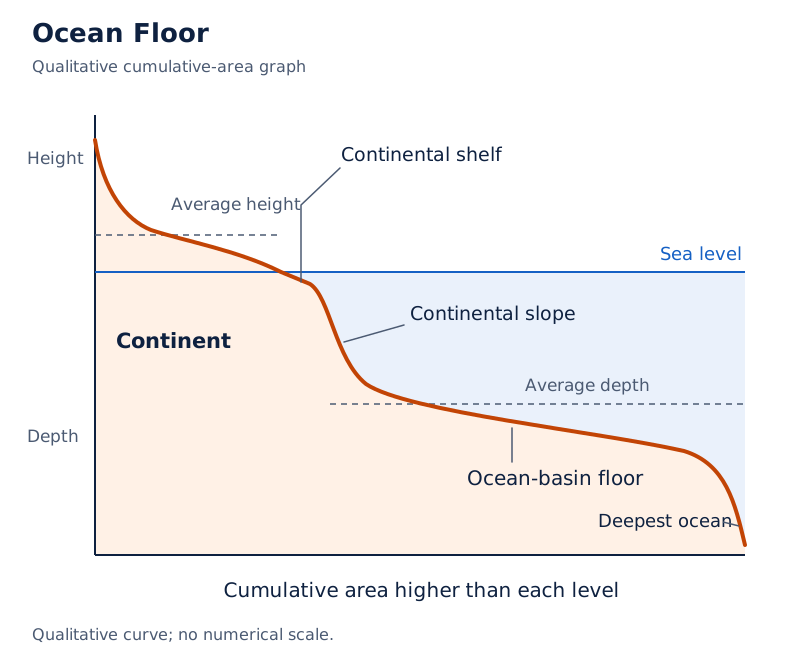
The profile labels the continent, continental shelf, continental slope, ocean-basin floor and deepest ocean. It marks sea level, average height and average depth, showing the contrast between elevated land and the submerged ocean floor.
Drawn by One Young India. See Fig. 4.1 in your NCERT textbook
The configuration of the ocean floor therefore provides different kinds of evidence. The ridges identify zones of volcanic activity, the trenches are linked with deep-seated earthquakes, and the plains show where continental sediments accumulate beyond the margins.
What patterns do earthquakes and volcanoes form?
The distribution of earthquakes shows belts of activity associated with major relief features. A line of earthquake centres in the central Atlantic runs almost parallel to the coastlines. It continues into the Indian Ocean and coincides with mid-oceanic ridges.
A little south of the Indian subcontinent, this line divides. One branch enters East Africa. The other meets a similar line extending from Myanmar to New Guiana. Another concentration follows the Alpine-Himalayan system and the Pacific rim.
How does earthquake depth vary?
In general, earthquake foci near mid-oceanic ridges occur at shallow depths. Earthquakes along the Alpine-Himalayan belt and the rim of the Pacific are deep-seated. The distinction between these settings became important in understanding the behaviour of oceanic crust.
What the figure shows
Distribution of earthquakes and volcanoes
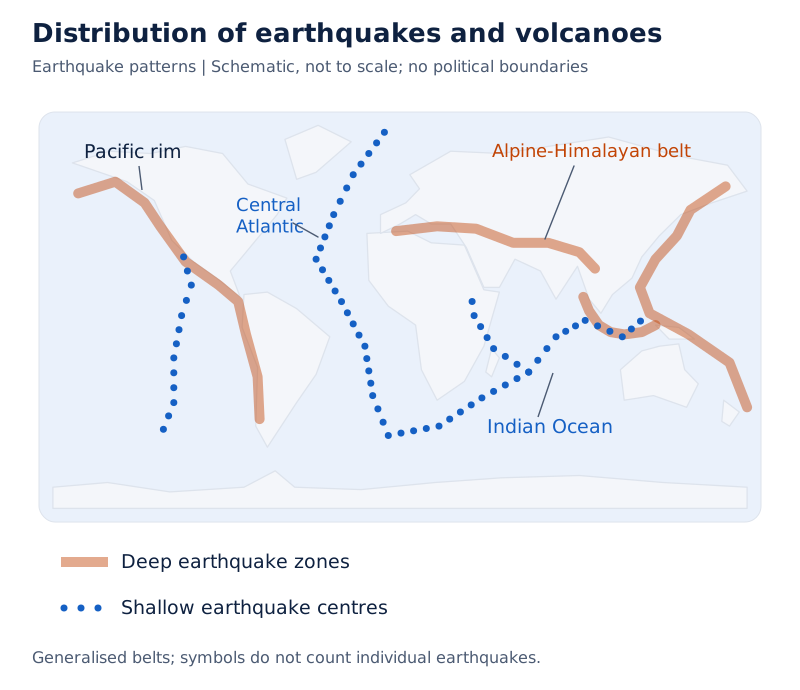
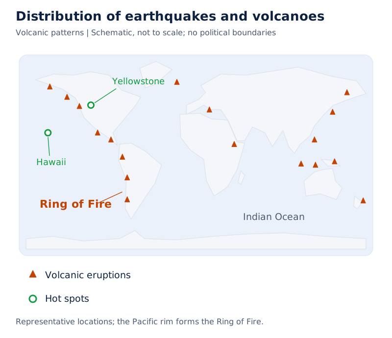
The world map distinguishes deep earthquake zones, shallow earthquake centres, volcanic eruptions and hot spots in its legend. The Pacific belt is labelled Ring of Fire, and earthquake centres also trace the central Atlantic.
Drawn by One Young India. See Fig. 4.2 in your NCERT textbook
Volcanoes show a similar distribution pattern. The Pacific rim is called the rim of fire because active volcanoes occur there. The association of volcanic activity, earthquake belts, ridges and trenches helped connect surface patterns with processes operating within the earth.
How does sea floor spreading explain oceanic crust?
Ocean-floor mapping and palaeomagnetic studies revealed evidence unavailable when Wegener proposed continental drift. Volcanic eruptions are common along mid-oceanic ridges and bring huge quantities of lava to the surface. The rocks also record patterns of age, composition and magnetic properties.
What observations supported Hess's hypothesis?
Rocks at equal distances on opposite sides of a ridge crest show remarkable similarities in formation period, chemical composition and magnetic properties. Rocks closest to the ridges have normal polarity and are the youngest. Rock age increases away from the crest.
| Evidence | Age or comparison | Significance |
|---|---|---|
| Oceanic crust rocks | Nowhere more than 200 million years old | Much younger than continental rocks. |
| Some continental rock formations | As old as 3,200 million years | Provide a contrast with the younger oceanic crust. |
| Ocean-floor sediment column | Nowhere found older than 200 million years | Unexpectedly thin compared with what scientists had anticipated for an old ocean floor. |
If ocean floors had been as old as continents, scientists expected a sediment sequence covering a much longer duration. Instead, the sediment record was unexpectedly limited. Deep-seated earthquakes in trenches and shallow earthquake foci near ridges supplied another important contrast.
How is crust formed, moved and consumed?
These observations and magnetic evidence led Hess in 1961 to propose sea floor spreading. The hypothesis linked eruptions at oceanic ridges with the movement of crust away from them and its consumption at oceanic trenches.
- Constant eruptions at the crest of an oceanic ridge cause the oceanic crust to rupture.
- New lava wedges into the rupture and pushes the oceanic crust on either side.
- The ocean floor spreads as crust moves away from the ridge crest.
- The ocean floor pushed away from the crest sinks at oceanic trenches and gets consumed.
The young age of oceanic crust required an explanation for its consumption. Hess also considered that the spreading of one ocean does not cause another to shrink. Crustal consumption at trenches formed part of his explanation.
What the figure shows
Sea floor spreading
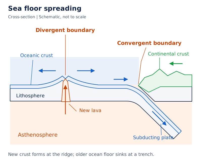
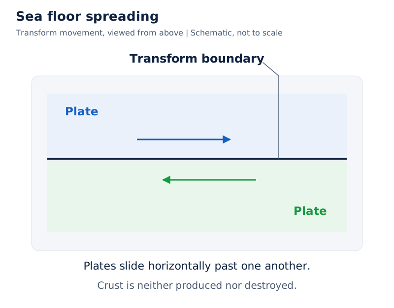
The cross-section labels divergent, convergent and transform plate boundaries. Arrows show movement near a spreading centre and descending plates at convergent margins. Lithosphere, asthenosphere, oceanic crust and continental crust are labelled.
Drawn by One Young India. See Fig. 4.3 in your NCERT textbook
What are tectonic plates, and which plates are important?
In 1967, McKenzie and Parker, and also Morgan, independently brought together the available ideas into the concept of plate tectonics. The concept extended the discussion from moving continents to moving units of the earth's lithosphere.
Definition: A tectonic or lithospheric plate is a massive, irregularly shaped slab of solid rock, generally composed of both continental and oceanic lithosphere.
Plates move horizontally over the asthenosphere as rigid units. The lithosphere includes the crust and top mantle. Its thickness varies between 5 and 100 km in oceanic parts and is about 200 km in continental areas.
A plate is called oceanic or continental according to which occupies the larger portion. The Pacific plate is largely oceanic, whereas the Eurasian plate may be called continental. The classification does not mean that a plate must consist entirely of one kind of lithosphere.
Which are the seven major plates?
- Antarctica and the surrounding oceanic plate.
- North American plate, including the western Atlantic floor, separated from the South American plate along the Caribbean islands.
- South American plate, including the western Atlantic floor, separated from the North American plate along the Caribbean islands.
- Pacific plate.
- India-Australia-New Zealand plate.
- Africa with the eastern Atlantic floor plate.
- Eurasia and the adjacent oceanic plate.
Young fold mountain ridges, trenches and/or faults surround the major plates. Their boundaries do not simply follow the outlines of continents, because the plates include oceanic areas as well as continental landmasses.
Where are some important minor plates?
| Minor plate | Location |
|---|---|
| Cocos | Between Central America and the Pacific plate. |
| Nazca | Between South America and the Pacific plate. |
| Arabian | Mostly the Saudi Arabian landmass. |
| Philippine | Between the Asiatic and Pacific plates. |
| Caroline | Between the Philippine and Indian plates, north of New Guinea. |
What the figure shows
Major and minor plates of the world
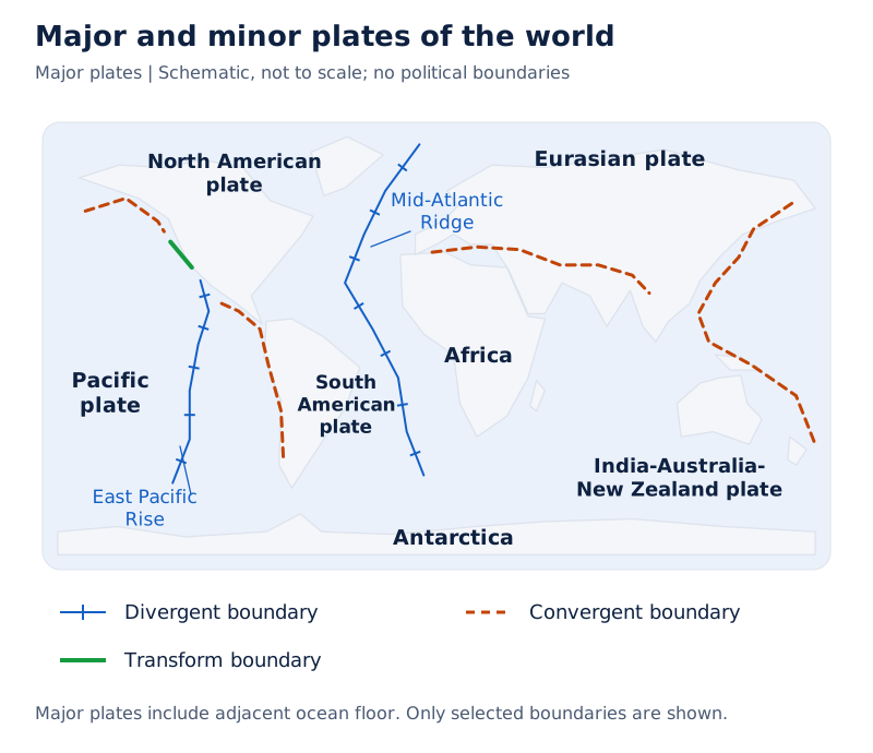
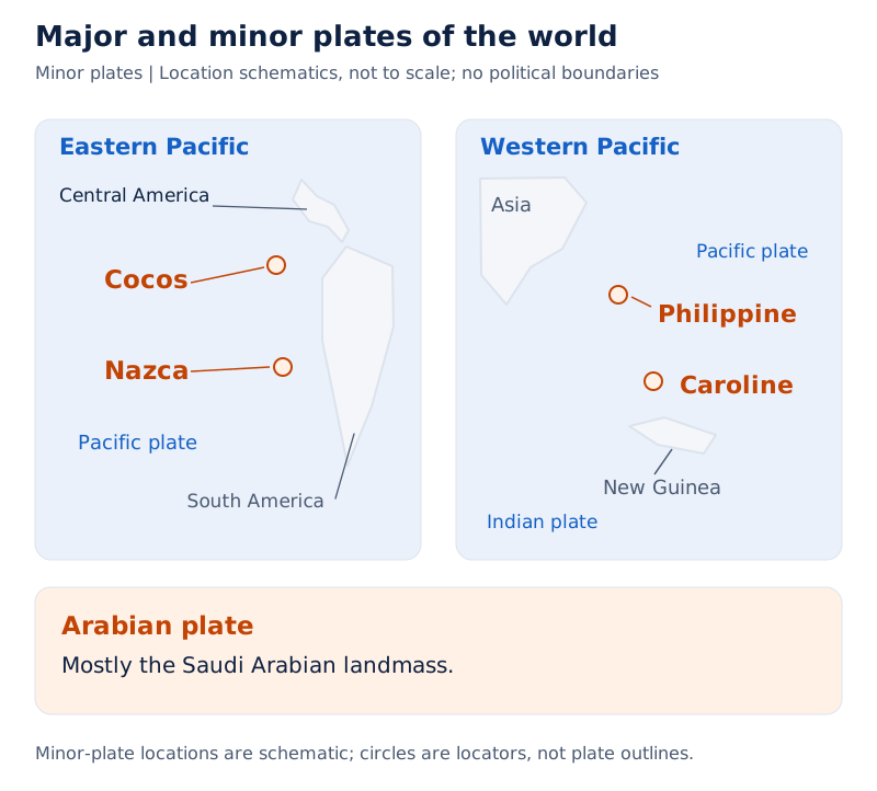
The map labels major plates and smaller plates including Cocos, Nazca and Caroline. Its legend distinguishes divergent, convergent and transform boundaries. Mid-Atlantic Ridge and East Pacific Rise are also labelled.
Drawn by One Young India. See Fig. 4.5 in your NCERT textbook
Continents are parts of plates; the plates are the moving units. All plates have moved in the geological past and will continue to move. Pangaea itself resulted from the convergence of continental masses carried on different plates.
Palaeomagnetic data allow earlier continental positions to be reconstructed. The past position of the Indian subcontinent, mostly Peninsular India, has been traced using rocks analysed from the Nagpur area. Continental movement therefore extends beyond the breakup of Pangaea.
How do divergent, convergent and transform boundaries differ?
Plate boundaries differ according to relative movement and what happens to the crust. The three types are divergent, convergent and transform. They explain where crust is generated, where it is destroyed and where neither process occurs.
What happens at each boundary?
| Boundary | Relative plate movement | Effect on crust |
|---|---|---|
| Divergent | Plates pull away from one another. | New crust is generated at spreading sites. |
| Convergent | One plate dives beneath another. | Crust is destroyed; the sinking location is a subduction zone. |
| Transform | Plates slide horizontally past one another. | Crust is neither produced nor destroyed. |
The Mid-Atlantic Ridge is the best-known divergent-boundary example. The American plates are separated there from the Eurasian and African plates. A divergent boundary is therefore also a spreading site, linking this boundary type with sea floor spreading.
Convergence can take place between an oceanic and continental plate, between two oceanic plates, or between two continental plates. These are the three combinations to distinguish when describing convergent boundaries.
Transform faults are planes of separation generally perpendicular to mid-oceanic ridges. Eruptions do not occur along the entire ridge crest at the same time, so portions of a plate move differentially. The earth's rotation also affects the separated blocks.
Note: Horizontal sliding at a transform boundary neither creates nor destroys crust. Do not confuse it with divergence, where new crust forms, or convergence, where crust is destroyed as a plate dives beneath another.
How fast do plates move, and what drives them?
Strips of normal and reverse magnetic field parallel to mid-oceanic ridges help scientists determine rates of plate movement. Rates vary considerably. They are not represented by a single speed that applies to every ridge or plate.
| Ridge or rise | Rate | Comparison |
|---|---|---|
| Arctic Ridge | Less than 2.5 cm/yr | Slowest rate. |
| East Pacific Rise near Easter Island | More than 15 cm/yr | Fastest rate; in the South Pacific, about 3,400 km west of Chile. |
The qualifiers less than and more than are part of these rates. The values describe a contrast between spreading locations, while the magnetic strips provide the evidence used to determine movement.
How does mantle convection work?
The mobile rock beneath rigid plates is believed to be moving in a circular manner. Heat within the earth comes from two main sources: radioactive decay and residual heat. The resulting circulation is called a convection cell or convective flow.
- Heated material beneath the rigid plates rises towards the surface.
- The rising material spreads and begins to cool.
- The cooled material sinks back into deeper parts of the earth.
- The cycle repeats, producing a convection cell or convective flow.
The slow movement of hot, softened mantle below the rigid plates drives plate movement. Arthur Holmes first considered the idea in the 1930s, and it later influenced Harry Hess's thinking about sea floor spreading.
At the time of Wegener's proposal, most scientists regarded the earth as solid and motionless. Sea floor spreading and plate tectonics instead emphasised a dynamic earth, with movement involving both its surface and its interior.
How has the Indian plate moved, and what were the consequences?
The Indian plate includes Peninsular India and the Australian continental portions. Its northern boundary follows the subduction zone along the Himalayas, representing continent-continent convergence. Other parts of its boundary include mountain belts, trenches and spreading sites.
Where do its boundaries extend?
In the east, the boundary extends through the Rakinyoma Mountains of Myanmar towards the island arc along the Java Trench. The eastern margin is a spreading site east of Australia, forming an oceanic ridge in the south-west Pacific.
The western margin follows the Kirthar Mountain of Pakistan. It continues along the Makrana coast and joins the spreading site from the Red Sea rift southeastward along the Chagos Archipelago.
The boundary between the Indian and Antarctic plates is an oceanic ridge, hence a divergent boundary. It runs in a roughly west-east direction and merges with a spreading site a little south of New Zealand.
Case study: India's northward journey
India was a large island off the Australian coast in a vast ocean. The Tethys Sea separated it from the Asian continent till about 225 million years ago. India is supposed to have started its northward journey about 200 million years ago, when Pangaea broke.
| Time | Position or event |
|---|---|
| About 140 million years before the present | The subcontinent lay as far south as 50°S latitude; the Tethys Sea separated the plates and the Tibetan block was nearer the Asiatic landmass. |
| Somewhere around 60 million years ago | Lava outpouring and formation of the Deccan Traps began, continuing for a long period while the subcontinent was still close to the equator. |
| About 40 to 50 million years ago | India collided with Asia, causing rapid uplift of the Himalayas. |
| From 40 million years ago and thereafter | The formation of the Himalayas took place. |
The Deccan Traps formed during the movement of the Indian plate towards the Eurasian plate. Their formation was associated with the outpouring of lava, while the subcontinent was still close to the equator.
What the figure shows
Movement of the Indian plate
The map shows Early India south of the equator, successive outlines labelled 71, 55, 38 and 10 million years ago, and India Today against the Eurasian Plate. The Indian Ocean and equator are labelled.
See Fig. 4.6 in your NCERT textbook
Scientists believe that Himalayan formation is still continuing and that the height of the Himalayas is rising even to this date. India's changing position, the Deccan lava outpouring and Himalayan uplift belong to the history of plate movement.
Glossary
- Pangaea — The single continental mass proposed by Wegener, whose name means all earth.
- Panthalassa — The mega-ocean surrounding Wegener's supercontinent Pangaea, with a name meaning all water.
- Laurasia — The northern continental mass formed when Pangaea first split into two large components.
- Gondwanaland — The southern continental mass formed during the initial division of Pangaea.
- Tillite — Sedimentary rock formed from glacial deposits, providing evidence of past climates and continental drift.
- Continental margins — Transitional areas between continental shores and deep-sea basins, including shelf, slope, rise and deep-oceanic trenches.
- Abyssal plains — Extensive plains between continental margins and mid-oceanic ridges where continental sediments accumulate beyond the margins.
- Mid-oceanic ridges — An interconnected submerged mountain system with a central rift at the crest and intense volcanic activity.
- Sea floor spreading — The spreading of oceanic crust as new lava wedges into ruptures at ridge crests and pushes crust aside.
- Tectonic plate — A massive, irregularly shaped slab of solid rock, generally containing both continental and oceanic lithosphere.
- Lithosphere — The earth's crust and top mantle, forming the rigid plates that move over the asthenosphere.
- Subduction zone — The location at a convergent boundary where one plate sinks beneath another.
- Transform boundary — A boundary where plates slide horizontally past each other, neither producing nor destroying crust.
- Convection cell — Repeated circulation in which heated material rises, spreads, cools and sinks back into deeper regions.
Common errors and misconceptions
- Misconception: Wegener was the first person to suggest that the Atlantic continents had been joined. Correct: Ortelius proposed this possibility in 1596; Wegener presented his comprehensive theory in 1912.
- Misconception: Bullard fitted the present shorelines. Correct: His 1964 computer-based fit used the 1,000-fathom line instead of the present shoreline.
- Misconception: Mesosaurus was adapted to the open ocean. Correct: It was a small reptile adapted to shallow brackish water, with skeletons found in two specified localities in South Africa and Brazil.
- Misconception: Wegener's proposed forces were widely accepted as sufficient. Correct: Most scholars considered his pole-fleeing and tidal forces totally inadequate.
- Misconception: Oceanic rocks become younger away from a ridge crest. Correct: Rocks nearest the ridge are youngest; age increases with distance from the crest.
- Misconception: A tectonic plate is simply a continent. Correct: Plates generally contain continental and oceanic lithosphere; continents are parts of the moving plates.
- Misconception: All plate boundaries generate new crust. Correct: Divergent boundaries generate crust, convergent boundaries destroy it, and transform boundaries neither produce nor destroy it.
- Misconception: India had reached its present position when the Deccan Traps began forming. Correct: The lava outpouring began somewhere around 60 million years ago, while the subcontinent was still close to the equator.
Exam-style questions with model answers
Q1. What were Pangaea and Panthalassa? [2 marks]
- Pangaea was the single continental mass proposed by Wegener; its name means all earth.
- Panthalassa was the mega-ocean surrounding this supercontinent; its name means all water.
Q2. Which forces did Wegener suggest for continental drift, and why were they criticised? [3 marks]
- Wegener suggested pole-fleeing force, which relates to the rotation of the earth. The earth's equatorial bulge is associated with this rotation.
- He also suggested tidal force, arising from the attraction of the moon and the sun and responsible for tides in oceanic waters.
- He believed these forces could act effectively over many million years, but most scholars considered them totally inadequate.
Q3. Explain the evidence supporting continental drift. [5 marks]
- The facing margins of Africa and South America match. Bullard's 1964 computer-based fit used the 1,000-fathom line instead of present shorelines.
- Rocks of 2,000 million years on the Brazilian coast match western African rocks. The earliest marine deposits on the two coastlines are Jurassic.
- Tillite and comparable Gondawana-type sedimentary successions in separated landmasses indicate similar glacial histories and support continental drift.
- Ghana's rich gold placer deposits lack local source rock, whereas gold-bearing veins occur in Brazil. The deposits derive from the Brazil plateau when the continents lay side by side.
- Fossil distributions also support earlier connections. Mesosaurus skeletons occur only in the Southern Cape province of South Africa and the Iraver formations of Brazil, presently separated by 4,800 km and an ocean.
Q4. Explain the observations and mechanism behind sea floor spreading. [5 marks]
- Volcanic eruptions along mid-oceanic ridges bring large amounts of lava to the surface. Rocks at equal distances on opposite sides match in age, chemical composition and magnetic properties.
- The youngest rocks occur nearest the ridge, and their age increases away from it. Oceanic crust rocks are nowhere more than 200 million years old.
- Ocean-floor sediments are unexpectedly thin, with no sediment column found older than 200 million years. Trenches have deep-seated earthquakes, while ridge earthquake foci are shallow.
- Hess proposed sea floor spreading in 1961. Constant ridge eruptions rupture crust, and new lava wedges into it, pushing the crust on either side.
- The displaced ocean floor sinks at oceanic trenches and is consumed. This accounts for crustal consumption alongside its formation at ridges.
Q5. Distinguish the three types of plate boundaries. [3 marks]
- At divergent boundaries, plates pull apart and new crust is generated. These are spreading sites, exemplified by the Mid-Atlantic Ridge.
- At convergent boundaries, crust is destroyed as one plate dives beneath another. The sinking location is a subduction zone.
- At transform boundaries, plates slide horizontally past one another. Crust is neither created nor destroyed. Transform faults are generally perpendicular to mid-oceanic ridges.
Q6. What is the basic difference between continental drift and plate tectonics? [3 marks]
- Wegener proposed that continents formed Pangaea and later drifted apart. Plate tectonics identifies lithospheric plates as the moving units, with continents forming parts of them.
- A tectonic plate generally contains both continental and oceanic lithosphere and moves as a rigid unit over the asthenosphere.
- Continental masses have wandered throughout geological time. Pangaea itself resulted from convergence of different continental masses carried on plates, rather than marking the beginning of all continental movement.
Q7. Describe India's northward movement and its major associated events. [5 marks]
- India was a large island off the Australian coast. It is supposed to have started its northward journey about 200 million years ago, when Pangaea broke.
- About 140 million years before the present, the subcontinent lay as far south as 50°S latitude. The Tethys Sea separated the plates, and the Tibetan block was closer to the Asiatic landmass.
- Lava outpouring and Deccan Trap formation began somewhere around 60 million years ago and continued for a long period. India was still close to the equator.
- India collided with Asia about 40 to 50 million years ago, causing rapid Himalayan uplift. Himalayan formation took place from 40 million years ago and thereafter.
- Scientists believe that the process is still continuing and that the Himalayas continue to rise.
Q8. How does convection help explain plate movement? [3 marks]
- Heat within the earth comes from radioactive decay and residual heat. The mobile rock below rigid plates is believed to move in a circular manner.
- Heated material rises, spreads, cools and sinks into deeper regions. Repetition produces a convection cell or convective flow.
- The slow movement of hot, softened mantle below the plates drives plate movement. Holmes considered the idea in the 1930s, later influencing Hess.
Key takeaways
- Wegener's continental drift theory proposed that Pangaea split into Laurasia and Gondwanaland before further fragmentation produced the present continents.
- Matching continental margins, rock ages, tillite, placer deposits and fossils support connections between landmasses now separated by oceans.
- Most scholars considered Wegener's pole-fleeing and tidal forces inadequate; mantle convection offered another explanation for movement.
- Rocks nearest mid-oceanic ridge crests are youngest, while rock age increases with distance from the crest.
- Sea floor spreading links lava entering ruptures at ridges with outward crustal movement and consumption at oceanic trenches.
- Tectonic plates generally contain continental and oceanic lithosphere and move as rigid units over the asthenosphere.
- Divergence generates crust, convergence destroys crust, and transform movement neither produces nor destroys crust as plates slide past one another.
- India's northward movement included Deccan lava outpouring near the equator and collision with Asia associated with rapid Himalayan uplift.
Test yourself
Why does the Ghana gold example support earlier continental connections?
Ghana has rich placer gold deposits without source rock in the region. Gold-bearing veins in Brazil supplied the deposits when the continents lay side by side.
What does tillite reveal about the history of landmasses?
Tillite forms from glacial deposits. Similar Gondawana-type successions indicate remarkably similar histories and provide evidence of palaeoclimates and continental drift.
How do earthquake depths generally differ between ridges and the Pacific rim?
In general, ridge earthquake foci are shallow, whereas earthquakes along the Pacific rim and Alpine-Himalayan belt are deep-seated.
Which three combinations of plates can converge?
Convergence can occur between an oceanic and a continental plate, between two oceanic plates, or between two continental plates.
What are the contrasting movement rates at the Arctic Ridge and East Pacific Rise?
The Arctic Ridge has the slowest rate, less than 2.5 cm/yr. The East Pacific Rise near Easter Island has the fastest, more than 15 cm/yr.
Which rocks helped trace earlier positions of the Indian subcontinent?
Rocks analysed from the Nagpur area helped trace the position of the Indian subcontinent, mostly Peninsular India.
What type of plate boundary follows the Himalayas?
The northern boundary of the Indian plate along the Himalayas represents continent-continent convergence.
Where was the Indian subcontinent when Deccan Trap formation began?
It was still close to the equator. Lava outpouring and Deccan Trap formation began somewhere around 60 million years ago.
Write about it
Turn a question from this chapter into a paper.
The Writing Studio has a structure guide, a rubric and citation tools for 15 formats, from essays to research papers. Drafting is free with an account. Learnacy Essential adds feedback from an AI writing coach and submission to The OYI Review.
Learnacy Essential is ₹1,499 for the year. Publication depends on review and is not guaranteed.