
Landforms and Their Evolution | CBSE Class 11 Geography Notes
On this page
Watch & explore
Start with a few high-quality watches, then dive into the notes below.

This note covers the development of the earth’s surface, the work of running water, water below the ground, moving ice, waves and wind, and the forms created by removal and deposition of earth materials.
What are landforms, and how do they evolve?
A landform is a small to medium tract of the earth’s surface. Several related landforms together make a landscape, a larger tract of the surface. Each landform has a particular shape, size and material composition.
Geomorphic processes are processes that shape the earth’s surface. Their agents include running water, groundwater, wind, glaciers and waves. Groundwater means water below the surface; glaciers are moving masses of ice.
Weathering breaks down or alters earth materials. After weathering has acted, agents perform erosion, the removal of material. Deposition, the laying down of transported material, follows erosion. Both removal and deposition change the surface.
What does evolution mean here?
Evolution of landforms means stages of transformation from one landform into another, or changes within an individual landform after it forms. Actions of most geomorphic processes and agents are slow, so their results take a long time to develop.
Continued action may change a landform slowly or quickly. Changes in climate, or vertical and horizontal movements of landmasses, might alter the processes themselves or their intensity. Thus, a landform has a history rather than a permanently fixed shape.
Definition: Youth, maturity and old age describe stages of landscape development somewhat comparable to stages of life.
Relief means differences in surface height. The reduction of high relief into lower hills and plains can occur through different agents. The resulting forms depend on the processes at work and the materials on which they act.
How does running water change a landscape through successive stages?
In humid regions receiving heavy rainfall, running water is considered the most important agent lowering the land surface. It acts as overland flow, water moving as a sheet, and as linear flow through streams and rivers in valleys.
A gradient is a slope. Most erosional forms made by running water are associated with vigorous, youthful rivers on steep gradients. Deposition may also occur there, but on a smaller scale than along medium to gentle slopes.
How do small channels become plains?
- Overland flow removes surface material by sheet erosion. Surface irregularities concentrate water into narrow or wider paths.
- Small, narrow channels called rills form. These enlarge into longer, wider channels called gullies, which deepen, widen, lengthen and unite into valleys.
- Down-cutting, erosion into the stream bed, dominates early development. Waterfalls and cascades, or descending steps in a stream, are removed during this development.
- As beds become gentler, down-cutting becomes less dominant and lateral erosion, sideways erosion of banks and valley sides, increases.
- Valley sides and divides, the higher ground separating drainage basins, are lowered. A drainage basin is the area drained by a river system.
- A lowland with faint relief retains low resistant remnants called monadnocks. The almost plain produced by stream erosion is a peneplain.
A floodplain is a plain built through river deposition. A meander is a loop-like channel pattern. These become especially important as slopes become gentle and streams increasingly work on their banks.
| Stage | Streams and valleys | Divides and surface features |
|---|---|---|
| Youth | Few, poorly integrated streams; shallow V-shaped valleys; absent or very narrow floodplains along main streams | Broad, flat divides with marshes, swamps and lakes; waterfalls and rapids may occur over local hard rocks |
| Maturity | Plentiful, well-integrated streams; deep V-shaped valleys; wider floodplains with possible meanders | Sharp divides; broad interstream areas, swamps and marshes disappear; waterfalls and rapids disappear |
| Old age | Few small tributaries with gentle gradients; streams meander freely over vast floodplains | Broad, flat divides with lakes, swamps and marshes; most of the landscape lies at or slightly above sea level |
Rapids are rapidly flowing stretches of a stream. Meanders, if present in youth, develop over broad upland surfaces and may eventually become deeply cut into them. A meandering course therefore does not by itself establish that the whole landscape is old.
Which erosional landforms does running water produce?
How do gorges and canyons differ?
A gorge is a deep valley with very steep to straight sides and almost equal widths at its top and bottom. A canyon has steep, step-like side slopes and is wider at the top than at the bottom.
A canyon may be as deep as a gorge and is a variant of it. Valley form depends on rock type and structure. Canyons commonly develop in horizontally bedded sedimentary rocks, while gorges form in hard rocks.
Case study: What does the Kaveri valley near Hogenekal show?
The Kaveri valley near Hogenekal in Dharmapuri district, Tamil Nadu, illustrates a gorge. Its narrow valley and steep rock walls provide a concrete example of the gorge form.
Photograph: The Kaveri river valley near Hogenekal, Dharmapuri district, Tamil Nadu, in the form of a gorge (NCERT Class 11 Figure 6.1). The photograph shows water between high, steep rock walls. The visible passage is narrow, with the rock faces rising sharply on both sides.
How are potholes and plunge pools formed?
Potholes are more or less circular depressions in rocky stream beds. Abrasion means wearing away by rock fragments. Pebbles and boulders collect in an initial hollow, rotate in flowing water and enlarge it. Neighbouring depressions eventually join, deepening the valley.
Plunge pools are large, deep holes at the foot of waterfalls. The impact of falling water and rotation of boulders produce these deep and wide depressions.
Incised or entrenched meanders are deep, wide meandering courses cut into hard rock. In steep-gradient streams, erosion normally concentrates on the channel bottom; lateral erosion is relatively limited compared with streams on gentle slopes.
River terraces mark former valley-floor or floodplain levels. They may be bare bedrock or contain river deposits, called alluvium. Terraces result from vertical erosion into a river’s own depositional floodplain, so they are basically erosional features.
Several terrace levels can mark former river-bed heights. Terraces at the same elevation on opposite sides of a river are called paired terraces. Their position records earlier levels of the valley floor.
How do rivers build fans, deltas and floodplain deposits?
Where does an alluvial fan form?
An alluvial fan forms where a stream leaves higher ground and enters a low-gradient plain at a mountain’s foot. Its normally coarse load, the material carried by the stream, becomes too heavy to transport along the gentler slope.
The material spreads into a broad cone. Usually, streams shift across a fan instead of remaining in their original channels for long. They form branching channels called distributaries. Fans in humid areas normally have low cones and gentle slopes; those in arid and semi-arid climates have high, steep cones.
How does a delta differ from a fan?
A delta develops where river load is spread into the sea. If the load is not carried far offshore or distributed along the coast, it accumulates as a low cone. As the delta grows seaward, its distributaries increase in length.
| Feature | Alluvial fan | Delta |
|---|---|---|
| Setting | Low-gradient plain at the foot of higher ground | River outlet into the sea |
| Deposition | Coarse load spreads when the stream enters gentler slopes | Load accumulates if it is not removed far offshore or along the coast |
| Arrangement of deposits | Lacks the very well-sorted, clearly layered arrangement characteristic of deltas | Very well sorted, with clear stratification, meaning layering |
| Channels | Usually shift across the fan, forming distributaries | Distributaries lengthen as the delta builds seaward |
In a delta, the coarsest material settles first; finer silt and clay travel farther into the sea. Sorting means separation of sediment by size. Sediment is material carried and deposited by an agent.
How are floodplain deposits arranged?
The active floodplain is the river bed made of river deposits. The inactive floodplain lies above the banks. It contains both channel deposits and flood deposits. Abandoned channels contain coarse deposits; spilled floodwaters deposit relatively finer silt and clay.
Natural levees are low, linear, parallel ridges of coarse deposits beside large rivers, quite often broken into separate mounds. Point bars, also called meander bars, are linear sediment deposits along meandering river banks, with mixed grain sizes and almost uniform profiles and widths.
Normally, relatively slow water in gentle channels carries fine sand, silt and clay. Deposits accumulate on the bed and above it when floodwater spills over the banks. Floodplains within a delta are called delta plains.
Why do meanders grow, and how do oxbow lakes form?
A meander is a channel pattern, not a landform in itself. Rivers rarely follow straight courses across large floodplains and delta plains. Gentle gradients allow flowing water to work sideways on banks.
The banks contain unconsolidated alluvial deposits, loose river-deposited materials with irregularities. Water exerts lateral pressure against these irregularities. The Coriolis force, a deflecting influence on moving water, also contributes to the tendency to meander.
How does a bend become a cut-off loop?
- On an extremely low gradient, slowly flowing water begins working laterally against slight bank irregularities.
- A small curvature develops and deepens through deposition inside the curve and erosion outside it.
- Normally, deposition occurs along the convex bank, the inner bank projecting into the channel. Undercutting occurs along the concave bank, the outer bank hollowed by the bend.
- The concave bank develops a steep slope or scarp; the convex bank has a long, gentle profile. Deep loops may be cut off by erosion where the channel curvature changes.
- The isolated loops remain as oxbow lakes. If neither deposition nor erosion or undercutting occurs, the tendency to meander is reduced.
What the figure shows
Meander growth and cut-off loops
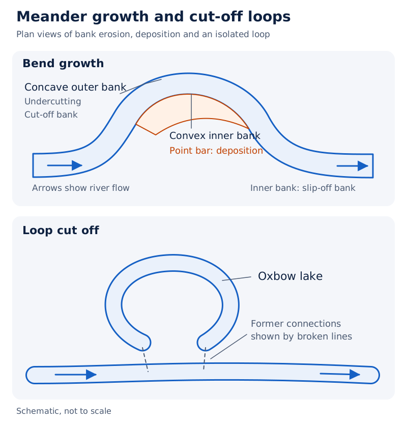
The drawing labels point bars, oxbow lakes, the slip-off or convex bank, and the cut-off or concave bank. Arrows show flow; broken lines indicate cut-off connections.
Drawn by One Young India. See Fig. 6.7 in your NCERT textbook
Case study: What does the Burhi Gandak near Muzaffarpur show?
The Burhi Gandak near Muzaffarpur, Bihar, provides an example of a meandering river with oxbow lakes and cut-offs. The satellite scene shows a winding active channel and curved traces beside it, illustrating channel change across a plain.
What the figure shows
River examples to locate
On an outline map of India, locate Tamil Nadu for the Kaveri gorge near Hogenekal and Bihar for the meandering Burhi Gandak near Muzaffarpur. Annotate each location with its associated river feature.
How does groundwater create erosional karst features?
Water percolates, or moves down through rock, where rocks are permeable, thinly bedded, jointed and cracked. Permeable rocks allow water through; bedding planes are surfaces between rock layers, and joints are fractures. At depth, water also moves horizontally.
Mechanical removal by groundwater is insignificant in developing landforms. In limestone and dolomite rich in calcium carbonate, a soluble chemical constituent, solution, the dissolving of material, and precipitation, its separation from solution as a deposit, produce varied features.
Karst topography is the assemblage of solution and depositional forms in such limestone or dolomitic regions. The name comes from the Karst region in the Balkans beside the Adriatic Sea.
How do holes, trenches and pavements develop?
Swallow holes are small to medium, round or nearly round shallow solution depressions. Sinkholes have more or less circular openings and funnel-shaped bottoms. Solution sinks form through dissolving alone; collapse sinks involve collapse into a cave or void below.
| Sinkhole measurement | Range |
|---|---|
| Area | A few square metres to a hectare, a unit of area |
| Depth | Less than 0.5 metre to 30 metres or more |
Solution sinks are more common than collapse sinks. Doline is sometimes used for a collapse sink. Quite often, soil covers sinkholes, giving them the appearance of shallow water pools.
Joined sinkholes and dolines form long trenches called valley sinks or uvalas. Joining occurs through slumping at their edges or collapse of cave roofs. Further solution leaves an irregular network of points, grooves and ridges called lapies.
Lapies especially develop through unequal solution along parallel to nearly parallel joints. A lapie field may eventually become a somewhat smooth limestone pavement. Surface runoff quite often enters holes, travels underground and re-emerges downstream through a cave opening.
What the figure shows
Karst features
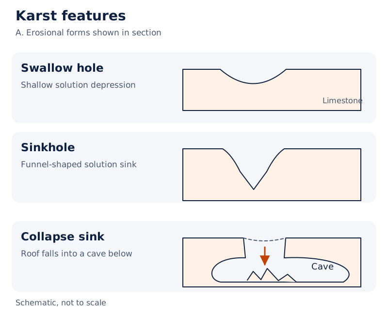
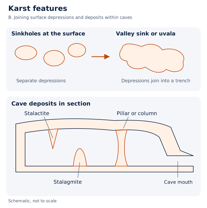
Separate sketches show swallow-hole, sinkhole and collapse-sink sections, surface sinkholes, and valley sinks or uvalas. A cave section labels its mouth and deposits hanging from the roof, rising from the floor and joining roof to floor.
Drawn by One Young India. See Fig. 6.8 in your NCERT textbook
How do limestone caves and their deposits develop?
Caves are long, narrow to wide underground gaps formed as limestone dissolves along bedding planes. Cave formation is prominent where limestone or dolomite alternates with other rock beds, or where limestone occurs in dense, massive, thick beds.
Water moves downward through materials, cracks and joints, then horizontally along bedding planes. Depending on the arrangement of limestone and intervening rocks, caves can form a maze at different elevations. They normally have an opening through which cave streams discharge.
Caves open at both ends are called tunnels. Chemical removal creates the underground spaces, but chemical deposition within those spaces builds another group of landforms.
How do stalactites, stalagmites and pillars differ?
Carbonated water is rainwater that has absorbed carbon dioxide. Calcium carbonate dissolves easily in it. When this water evaporates or loses carbon dioxide while trickling across rough rock, calcium carbonate is deposited.
| Deposit | Position and form |
|---|---|
| Stalactite | Hangs like an icicle; normally broad at its attached base and tapering towards its free end |
| Stalagmite | Rises from the cave floor, formed by dripping water from above or through a stalactite |
| Column or pillar | Forms when stalactites and stalagmites eventually join; diameters vary |
A stalagmite may resemble a column or disc, with a smooth, rounded bulging end or a small crater-like depression. The position of attachment distinguishes it from a stalactite; both result from deposition rather than from mechanical carving of the cave.
How do glaciers erode mountains and valleys?
Glaciers move as ice sheets or linear flows down mountain slopes. A continental glacier spreads as a sheet over land. A piedmont glacier is a vast sheet spread over plains at the foot of mountains. Mountain and valley glaciers occupy broad trough-like valleys.
Movement is slow compared with flowing water and occurs basically through gravity. The ice’s weight creates tremendous friction. Plucking removes rock fragments, usually large angular blocks, which are dragged along valley floors and sides and cause abrasion.
Glaciers can damage even unweathered rock. Continued removal lowers divides and reduces slopes, eventually leaving low hills, plains and deposits. At a sufficiently reduced slope, glaciers stop moving.
Which forms reveal glacial erosion?
A cirque is a deep, long, wide basin with very steep, inward-curving to vertical walls. Cirques are the most common forms in glaciated mountains and quite often occur at valley heads. A tarn is a lake quite often left in a cirque after ice disappears.
Horns are high, sharp, steep-sided peaks formed when three or more radiating glaciers erode headward until their cirques meet. Arêtes are narrow, saw-toothed ridges with sharp crests and zig-zag outlines, produced between progressively eroded cirque walls.
Glacial troughs are U-shaped valleys with broad floors and relatively smooth, steep sides. They may contain debris and lakes. Hanging valleys stand above the main valley on one or both sides; their projecting ridges are quite often cut into triangular faces.
Fjords, also spelt fiords, are very deep glacial troughs filled with seawater along shores at high latitudes, far from the equator. These are submerged glacial valleys, rather than deposits accumulated at a river mouth.
What the figure shows
Glacial landscape
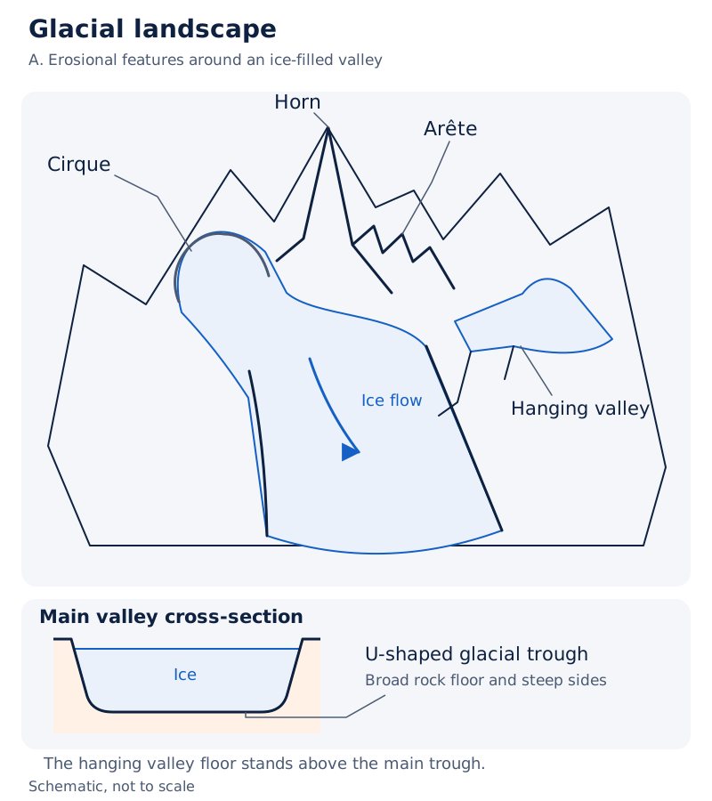
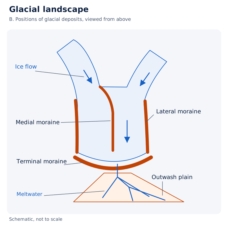
The drawing labels a cirque, horn, arête and hanging valley around ice-filled valleys. It also shows ridges of glacial deposits beside and within the ice and at its end, with a plain of meltwater deposits beyond.
Drawn by One Young India. See Fig. 6.11 in your NCERT textbook
What landforms result from glacial deposition?
Glacial till is the unsorted mixture of coarse and fine debris dropped by melting glaciers. Most fragments are angular to sub-angular. Glacio-fluvial deposits are deposits made by streams of glacial meltwater; they are also called outwash deposits.
Unlike till, outwash is roughly layered and sorted. Its fragments have somewhat rounded edges. This distinction separates direct deposition by melting ice from deposition by streams carrying debris away from ice.
Where do different moraines occur?
Moraines are ridges of glacial till. Their names distinguish their locations and forms. Ground moraines also occur as irregular sheets, while medial moraines are imperfectly formed compared with lateral moraines.
| Type | Location or character |
|---|---|
| Terminal moraine | Long ridge of debris at the glacier’s end or toe |
| Lateral moraine | Along the sides, parallel to the glacial valley; may join a terminal moraine in a horseshoe-shaped ridge |
| Ground moraine | Irregular till sheet across a valley floor, varying greatly in thickness and surface form |
| Medial moraine | In the valley centre between lateral moraines; sometimes indistinguishable from ground moraine |
How do eskers, outwash plains and drumlins form?
An esker is a winding ridge left by a stream beneath a glacier. Meltwater accumulates below ice and flows over the ground with ice forming its banks. Coarse blocks, boulders and smaller debris settle there; melting ice exposes the ridge.
Outwash plains form when broad, flat fans of meltwater deposits join at mountain feet or beyond continental ice sheets. Their materials include gravel, silt, sand and clay.
Drumlins are smooth, oval ridges made mainly of till, with some gravel and sand. Their long axes parallel ice movement. The stoss end, facing the glacier, is blunter and steeper than the other end, called the tail.
Rock debris is dumped beneath heavily loaded ice through fissures, or cracks. Moving ice pushes against and blunts the stoss end. Drumlins therefore indicate the direction of glacier movement.
| Glacial measurement | Extent or rate |
|---|---|
| Glacier movement | Could be a few centimetres to a few metres a day, or even less or more |
| Drumlin length | May measure up to 1 kilometre |
| Drumlin height | May measure 30 metres or so |
How do waves and currents reshape coasts?
Most coastal changes are accomplished by waves. Breaking waves strike the shore and churn seabed sediment. A location can experience erosion in one season and deposition in another. Storm waves and tsunami waves, sea waves caused by sudden displacement of water, can cause far-reaching changes quickly.
Coastal form also depends on the shape of the land and sea floor, and whether the coast advances seaward or retreats landward. Assuming sea level is constant, high rocky submerged coasts and low sedimentary emerged coasts illustrate contrasting development.
How do high and low coasts differ?
| Characteristic | High rocky coast | Low sedimentary coast |
|---|---|---|
| Appearance | Irregular, indented shoreline with steep hillsides; rivers appear drowned | Smooth shoreline with gently sloping land; rivers appear to lengthen by building plains and deltas |
| Dominant features | Erosional forms; initially no shore depositional forms | Depositional forms; marshes and swamps may abound |
| Development | Cliff retreat reduces shoreline irregularities | Churned sediment readily builds bars and enclosed water bodies |
Sea cliffs are steep coastal rock faces. Almost all are steep and may range from a few metres to 30 metres or even more. Retreat leaves a wave-cut platform, a flat or gently sloping surface in front of the cliff; a platform above average wave height is a wave-cut terrace.
Wave impact and rock debris enlarge hollows into sea caves. Roof collapse drives further cliff retreat. Resistant remnants may survive offshore as sea stacks, isolated rock masses formerly belonging to a cliff or hill. These are temporary features.
How do beaches, spits and lagoons develop?
A wave-built terrace can develop offshore in front of the wave-cut terrace. It develops after considerable cliff retreat smooths the coastline somewhat and further material is added to the offshore deposits.
Beaches are temporary deposits along shores, mostly made of sand. Shingle beaches contain small pebbles and cobbles, or larger rounded stones. Sand lifted from beaches can accumulate behind them as dunes, wind-deposited sand ridges or mounds.
An offshore bar is a sand-and-shingle ridge approximately parallel to the coast. When more sand raises it above water, it becomes a barrier bar. A barrier attached to one end of a bay is a spit; spits may also attach to projecting headlands.
A lagoon, a coastal water body cut off from the open sea, forms as bars and spits extend across a bay and restrict its opening. Sediment gradually fills it, and a broad coastal plain may replace it. Maintaining these depositional features depends on a steady material supply.
What the figure shows
Contrasting Indian coasts to locate
On an outline map of India, label the west coast as high, rocky and retreating, with erosional forms dominant. Label the east coast as low and sedimentary, with depositional forms dominant.
Offshore bars absorb most destructive storm or tsunami force first. Barriers, beaches, dunes and mangroves, if present, provide further buffers. Disturbing the coastal sediment budget, the supply and balance of sediment, and mangroves can leave human settlements exposed to the first strike.
How do wind and running water erode desert landscapes?
Wind is one of the two dominant agents in hot deserts. Dry, bare floors heat rapidly, warming the air above them. Rising warm air and obstructions create turbulence, irregular air movements including eddies, whirlwinds and upward or downward currents.
Deflation lifts and removes dust and small particles from rock surfaces. Sand and silt carried by wind abrade the surface. Impact is the force of wind-blown sand striking rock, comparable to sand-blasting.
Why is desert erosion not the work of wind alone?
Many desert forms owe their origin to mass wasting, downslope movement of weathered material, and running water as sheet floods. Rain is scarce but falls torrentially over short periods. Exposed rocks undergo weathering, and rain readily removes the loosened material.
Wind moves fine material, while general mass erosion is accomplished mainly by sheet floods or sheet wash, water spreading across the surface. Desert stream channels are broad, smooth and indefinite, flowing briefly after rain.
How do pediments expand into pediplains?
- Streams erode laterally and sheet floods remove material along mountain fronts, producing gently inclined rocky floors called pediments.
- A pediment may have a thin debris cover or none. Above it lie a steep wash slope and a cliff or free face.
- The slope and free face retreat backwards through backwasting, also called parallel retreat of slopes.
- Pediments extend at the mountain front’s expense. A mountain remnant is left as an inselberg.
- High desert relief is reduced to low, featureless plains called pediplains.
A playa is a shallow, short-lived lake in a desert basin. Sediment from surrounding margins builds a nearly level basin floor, covered by water when enough is available. Evaporation removes the water; quite often salts accumulate. Salt-covered playa plains are alkali flats.
Persistent wind removal may form deflation hollows, shallow surface depressions. Wind-blown sand creates rock-face depressions called blow outs; some enlarge into caves. Resistant remnants become mushroom rocks with narrow stalks and broad caps, table rocks with flat tops, or pedestal-like forms.
How does wind deposit sand and produce different dunes?
Wind is a good sorting agent. Grains move by rolling, saltation, or hopping, and suspension, being carried within the air. Different grain sizes move according to wind velocity, meaning speed, so transport itself sorts the material.
As wind slows, grains settle according to their size and critical velocity, the wind speed needed to keep them moving. Wind deposits therefore show good sorting. Dry hot deserts favour dunes, and obstacles that initiate accumulation are equally important.
What conditions produce each dune form?
| Dune | Shape and orientation | Conditions |
|---|---|---|
| Barchan | Crescent-shaped, with wings pointing downwind, in the direction the wind travels | Constant, moderate wind and an almost uniform original surface |
| Parabolic dune | A reversed barchan for the same wind direction | Sand surfaces partly covered by vegetation |
| Seif | Similar to a barchan but with one wing, which can become very long and high | A shift in wind conditions |
| Longitudinal dune | Long ridge of considerable length but low height | Poor sand supply and constant wind direction |
| Transverse dune | Aligned across, or perpendicular to, wind direction; may be very long and low | Constant wind and an elongated sand source at right angles to that direction |
What the figure shows
Types of sand dunes
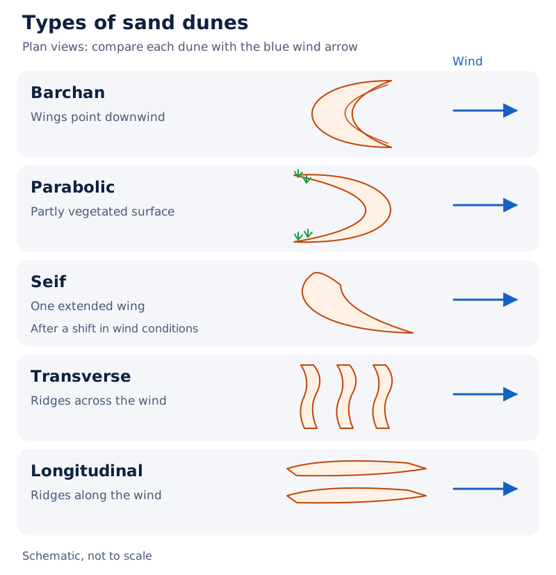
The drawing labels barchan, seif, parabolic, transverse and longitudinal forms. Arrows indicate wind direction, allowing the crescent forms and the alignment of the long ridges to be compared.
Drawn by One Young India. See Fig. 6.14 in your NCERT textbook
Where sand is plentiful, regularly shaped dunes quite often merge and lose their individual characteristics. Most desert dunes shift. A few become stabilised, especially near human habitations, so dunes should not all be treated as fixed surface features.
Glossary
- Landform — A small to medium tract of the earth’s surface with its own shape, size and materials.
- Landscape — A large tract of the earth’s surface made up of several related landforms.
- Peneplain — An almost plain produced by stream erosion, with faint relief and possible resistant remnants.
- Gorge — A deep valley with very steep to straight sides and almost equal top and bottom widths.
- River terrace — A surface marking an older valley-floor or floodplain level, produced through vertical stream erosion.
- Alluvial fan — A cone-shaped deposit formed where a stream enters a gentler plain at the foot of higher ground.
- Meander — A loop-like river-channel pattern associated with lateral action along the banks.
- Karst topography — Limestone or dolomitic terrain with characteristic landforms produced through groundwater solution and deposition.
- Cirque — A deep glacial basin with steep walls at its head and along its sides.
- Glacial till — Unsorted coarse and fine debris dropped by melting glaciers, with mostly angular to sub-angular fragments.
- Esker — A winding ridge of deposits left after ice surrounding a subglacial stream melts.
- Spit — A barrier attached to one end of a bay, or to a headland or hill.
- Pediment — A gently inclined rocky floor at a mountain foot, with or without a thin debris cover.
- Deflation — The lifting and removal of dust and smaller particles from rock surfaces by wind.
- Barchan — A crescent-shaped sand dune with wings pointing downwind, formed under constant moderate wind conditions.
Common errors and misconceptions
- Misconception: Rivers deposit material only on gentle slopes. Correct: Deposition may occur on steep slopes too, but on a smaller scale than on medium to gentle slopes.
- Misconception: Every river terrace is a depositional landform. Correct: Terraces are basically erosional products, formed when a stream cuts vertically into an earlier floodplain.
- Misconception: A meander is a landform proving that a river landscape is old. Correct: It is a channel pattern; meanders may develop on broad upland surfaces during youth.
- Misconception: Stalactites grow from cave floors. Correct: Stalactites hang from above; stalagmites rise from the floor and may eventually join them as pillars.
- Misconception: Glacial till and outwash have the same sediment arrangement. Correct: Till is unsorted, whereas outwash is roughly sorted and layered, with somewhat rounded fragment edges.
- Misconception: Beaches and sea stacks are permanent features. Correct: Both are temporary; beaches can change seasonally and stacks eventually disappear through wave erosion.
- Misconception: Wind alone produces desert erosion. Correct: Wind moves fine material, while sheet floods or sheet wash accomplish general mass erosion mainly.
- Misconception: All desert dunes remain fixed. Correct: Most shift; a few become stabilised, especially near human habitations.
Exam-style questions with model answers
Q1. A river flows rapidly down a steep mountain slope, then enters a gently sloping plain. Erosion concentrates on the bed in the steep reach; on gentler slopes its speed falls and its load settles. Identify the dominant action in each reach. [2 marks]
- In the steep mountain reach, erosion is concentrated on the channel bottom, so down-cutting is the dominant action.
- In the gently sloping reach, reduced speed allows transported load to settle, favouring deposition.
Q2. Valley A has very steep to straight sides and almost equal widths at its top and bottom. Valley B has steep, step-like sides and is wider at the top. Identify both types using these observations. [2 marks]
- Valley A is a gorge: its steep to straight sides and almost equal upper and lower widths match that form.
- Valley B is a canyon: its stepped sides and greater width at the top distinguish it from the gorge.
Q3. Compare fans and deltas using these facts: a fan forms at a mountain foot when coarse load enters gentler slopes; a delta accumulates at a river’s sea outlet if sediment is not carried away; delta deposits are very well sorted and clearly layered, unlike fan deposits. Give three differences. [3 marks]
- A fan forms on a low-gradient plain at a mountain foot, whereas a delta forms where a river delivers sediment into the sea.
- Fan deposition follows the inability to carry coarse load over gentler slopes; delta accumulation requires sediment to remain near the outlet.
- Delta deposits are very well sorted and clearly layered, unlike the deposits making up an alluvial fan.
Q4. Explain meander change from these observations: a stream on an extremely gentle slope works laterally; slight bank irregularities develop into bends; normally deposition builds the convex inner bank and erosion undercuts the concave outer bank; deep loops may be cut off, leaving isolated water bodies. Give four linked points. [4 marks]
- The extremely gentle slope allows the stream to flow slowly and work laterally against irregularities in its banks.
- These irregularities develop into bends, whose curvature grows as deposition occurs inside the bend and erosion outside it.
- Normally, the convex inner bank receives deposits, while the concave outer bank is undercut by the flowing water.
- As loops deepen, they may be cut off through erosion, leaving the isolated loop as an oxbow lake.
Q5. Explain desert erosion in five points using this evidence: wind removes dust and small particles; wind-carried sand and silt abrade rock; blowing sand strikes rock with force, like sand-blasting; scarce rain falls torrentially for short periods and removes weathered debris; general mass erosion occurs mainly through sheet floods or sheet wash, while channels flow briefly after rain. [5 marks]
- Wind performs deflation by lifting and removing dust and smaller particles from rock surfaces. This removes fine material from the exposed ground.
- Sand and silt carried during transport act as abrasive tools. Their contact with the land surface wears away the exposed rock.
- Wind-blown sand also strikes rock with force. This impact contributes to erosion and is comparable to the action of sand-blasting.
- Rain is scarce, but short periods of torrential rainfall remove weathered debris. Running water therefore participates in shaping desert landscapes.
- General mass erosion is accomplished mainly through sheet floods or sheet wash. Desert channels flow briefly after rain, so wind is not the sole agent.
Q6. Explain pediplain development in five stages from these facts: lateral stream erosion and sheet floods erode mountain fronts; gently inclined rocky floors form at their feet; a steep wash slope and cliff stand above them; these retreat backwards by backwasting; the rocky floors expand, reducing mountains to low plains with mountain remnants. [5 marks]
- Lateral stream erosion and sheet flooding attack the mountain front. Their combined action begins the development of rocky floors near its foot.
- The gently inclined floors are pediments. Their formation provides the lower surface beside the mountain that will extend as erosion continues.
- A steep wash slope and cliff stand above the pediment. They retreat backwards through backwasting, also described as parallel retreat of slopes.
- As retreat continues, pediments extend backwards at the expense of the mountain front. The area occupied by the original mountain is progressively reduced.
- The final low, featureless plains are pediplains. Mountain remnants remain as inselbergs within the landscape produced by this reduction of relief.
Q7. Identify four dunes from these descriptions: A is crescent-shaped with downwind wings under constant moderate wind; B resembles a reversed barchan on partly vegetated sand; C is similar to a barchan but has one wing after changed wind conditions; D is a long, low ridge under constant wind with poor sand supply. [4 marks]
- A is a barchan: its crescent outline and downwind wings match formation under constant, moderate wind conditions.
- B is a parabolic dune: partial vegetation is associated with a form resembling a reversed barchan.
- C is a seif: the one-wing form follows a shift in wind conditions affecting a barchan-like dune.
- D is a longitudinal dune: a poor sand supply and constant wind direction produce a long ridge of low height.
Q8. Explain wind sorting in three points using these facts: different grain sizes move by rolling, hopping or suspension according to wind speed; transportation separates grains by size; as wind slows, grains settle according to their size and the speed needed to keep them moving. [3 marks]
- Wind transports different grain sizes according to its speed, moving them by rolling, hopping or suspension within the air.
- During transport, these differences in movement separate grains according to size. Sorting therefore occurs before the material is finally deposited.
- As wind slows, grains settle according to their sizes and the speed needed to move them, producing well-sorted wind deposits.
Key takeaways
- Landforms evolve through continued geomorphic action; changes in climate and land movements might alter either processes or their intensity.
- Running water generally shifts from dominant down-cutting towards stronger lateral erosion as stream gradients become gentler.
- Fans, deltas and floodplains result from deposition, while river terraces record erosion into older valley-floor or floodplain levels.
- Meanders are channel patterns; normally their convex banks receive deposits while concave banks undergo undercutting.
- Groundwater shapes karst mainly through solution and deposition, creating both erosional hollows and deposits within caves.
- Glaciers erode through abrasion and plucking; melting ice leaves till, while meltwater produces roughly sorted and layered outwash.
- Waves create erosional and depositional coastal forms, whose development also depends on land configuration and sediment supply.
- Desert landscapes reflect both wind and running water; dune shapes vary with sand supply, vegetation and wind conditions.
Test yourself
How does a peneplain differ from a pediplain?
A peneplain is an almost plain produced by stream erosion. A pediplain is a low, featureless desert plain formed through expanding pediments and mountain-front retreat.
Why is a river terrace basically an erosional feature?
It forms when a stream cuts vertically into its earlier depositional floodplain, leaving a surface that marks a former valley-floor or floodplain level.
What separates a solution sink from a collapse sink?
A solution sink forms through dissolving alone. A collapse sink involves the fall of material into an underlying cave or void.
Where does a stalagmite grow, and what may happen when it meets a stalactite?
A stalagmite grows upward from the cave floor. It may join a stalactite hanging from above to form a pillar or column.
Which end of a drumlin faces the glacier?
The stoss end faces the glacier and is blunter and steeper than the other end, which is called the tail.
How does an offshore bar become a barrier bar?
Further accumulation of sand raises the offshore bar until it is exposed above the water, producing a barrier bar.
What distinguishes barchans from parabolic dunes?
Barchans have crescent shapes with downwind wings. Parabolic dunes develop on partly vegetated sand and resemble reversed barchans for the same wind direction.
Why must running water be included in an explanation of desert erosion?
Scarce rain can fall torrentially, removing weathered debris. General mass erosion is accomplished mainly through sheet floods or sheet wash, while wind moves fine material.
Write about it
Turn a question from this chapter into a paper.
The Writing Studio has a structure guide, a rubric and citation tools for 15 formats, from essays to research papers. Drafting is free with an account. Learnacy Essential adds feedback from an AI writing coach and submission to The OYI Review.
Learnacy Essential is ₹1,499 for the year. Publication depends on review and is not guaranteed.