
Movements of Ocean Water | CBSE Class 11 Geography Notes
On this page
Watch & explore
Start with a few high-quality watches, then dive into the notes below.
This note covers movements of ocean water, the formation and characteristics of waves, the causes and types of tides, the Bay of Fundy, the importance of tides, the forces driving ocean currents, their classification and distribution, and their effects on coastal climates and fishing.
How do waves, tides and currents differ?
Ocean water is dynamic, meaning that it is in motion. Its temperature, salinity, or salt content, and density, or mass per unit volume, influence its movements. External influences include the sun, moon and winds.
Horizontal motion is movement across the ocean and includes waves and currents. Vertical motion is upward or downward movement, including the rise and fall of sea level during tides. Cold water rising from below the surface and surface water sinking are also vertical movements.
Definition: Ocean currents are continuous flows of huge amounts of water in a definite direction. Waves carry energy across the ocean surface. A tide is the periodical rise and fall of sea level, once or twice a day, mainly due to the attraction of the sun and moon.
What actually moves?
| Movement | Main feature | Movement of water |
|---|---|---|
| Waves | Energy travels across the surface. | Water particles travel in small circles as a wave passes. |
| Tides | Sea level rises and falls periodically. | The ocean surface rises and falls mainly under the attraction of the sun and moon. |
| Ocean currents | Water follows a definite path and direction. | Water moves from one place to another. |
Upwelling means the upward movement of cold water from below the surface. It belongs with vertical motions, as does the sinking of surface water. The distinction between these motions helps separate the advance of wave energy from the actual transfer of water by a current.
How do ocean waves form, travel and break?
Wind supplies energy to waves. Most waves form when wind drives against water. A breeze of two knots or less forms small ripples on calm water; knots are units used to measure speed. Ripples grow as wind speed increases, until white caps appear in breaking waves.
Waves continue to grow as they move and absorb wind energy. The maximum wave height depends on wind strength, how long the wind blows and the area over which it blows in a single direction. The largest waves occur in the open oceans.
How does the wave advance?
A crest is the highest point of a wave, and a trough is its lowest point. Gravity is the attractive force pulling water downwards. Wind pushes the water in its course while gravity pulls the crests down.
- Wind pushes the water body along its course and supplies energy to the waves.
- Gravity pulls a crest downwards as the wave develops.
- The falling water pushes the former trough upwards, moving the wave to a new position.
- Water beneath the wave follows a circular motion: up and forward as the wave approaches, then down and back as it passes.
What the figure shows
Motion of waves and water molecules
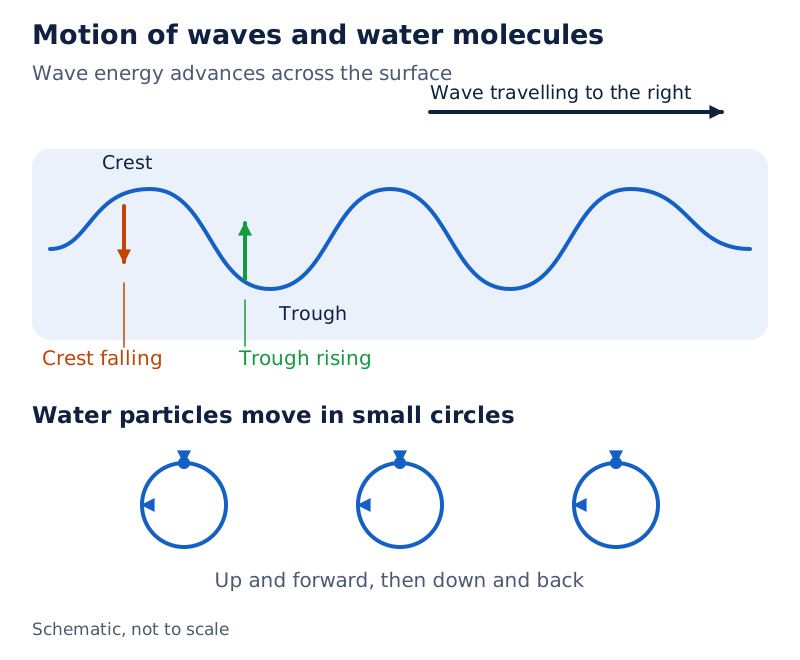
A rightward arrow marks the travelling wave. Arrows labelled “Crest falling” point downwards, while “Trough rising” arrows point upwards. Circular paths beneath the surface show the motion of water particles.
Drawn by One Young India. See Fig. 13.1 in your NCERT textbook
What changes near the shore?
Wavelength is the horizontal distance between successive crests. As a wave approaches the beach, friction between moving water and the sea floor slows it. The wave breaks when water depth becomes less than half its wavelength. Its energy is released along the shoreline.
Waves may travel thousands of kilometres before breaking ashore as surf, the breaking waves at the shore. Surface motion seldom affects the stagnant deep bottom water. Steep waves are fairly young and probably formed by local wind; slow, steady waves come from far away, possibly another hemisphere, one of the earth’s halves north or south of the equator, the line dividing these halves.
How are the characteristics of waves measured?
Wave measurements describe height, spacing, timing and movement. Keep a vertical measurement separate from a horizontal one: wave height runs from the bottom of a trough to the top of a crest, whereas wavelength runs horizontally between successive crests.
Wave amplitude is one-half of wave height. Amplitude and height therefore describe related measurements, but they are not interchangeable. A description of a wave must make clear which measurement is being used.
Which terms describe distance and time?
| Characteristic | Meaning | What to distinguish |
|---|---|---|
| Crest and trough | The highest and lowest points of a wave respectively. | These name positions, rather than distances. |
| Wave height | Vertical distance from trough bottom to crest top. | Height differs from horizontal wavelength. |
| Wave amplitude | One-half of wave height. | Amplitude differs from the full height. |
| Wavelength | Horizontal distance between successive crests. | Distance differs from the time between crests. |
| Wave period | Time between successive crests or troughs passing a fixed point. | Period measures a time interval. |
| Wave speed | Rate at which a wave moves through water, measured in knots. | Speed describes the advancing wave. |
| Wave frequency | Number of waves passing a given point in one second. | Frequency counts waves within a time interval. |
Wave period and wave frequency both involve observing a fixed point. For period, time the interval between successive crests or successive troughs. For frequency, count the waves passing during a one-second interval. These observations describe different aspects of the same passing waves.
Note: Wave speed describes how quickly the wave advances. It does not mean that each water particle travels forward across the ocean with the wave. The particles beneath a passing wave move in circles.
Why do tides produce two major bulges?
Tides differ from surges, which are movements of water caused by weather effects such as winds and changes in atmospheric pressure, the pressure exerted by air. Surges are not regular like tides. Tides vary greatly in frequency, magnitude and height across places and times.
The moon's gravitational pull acts to a great extent, and the sun's pull to a lesser extent, in producing tides. Centrifugal force acts to counterbalance gravity. Together, gravitational attraction and centrifugal force produce two major tidal bulges, or raised portions of ocean water.
How do the two sides of the earth differ?
- On the side nearest the moon, the moon's attractive force is greater than centrifugal force.
- The resulting force produces a tidal bulge towards the moon.
- On the opposite side, the moon's attraction is less because that side is farther from the moon; centrifugal force is dominant.
- The resulting force away from the moon produces a second bulge on the opposite side.
The tide-generating force is the difference between lunar gravitational attraction and centrifugal force. At the earth's surface, horizontal tide-generating forces are more important than vertical forces in producing tidal bulges.
What the figure shows
Relation between gravitational forces and tides
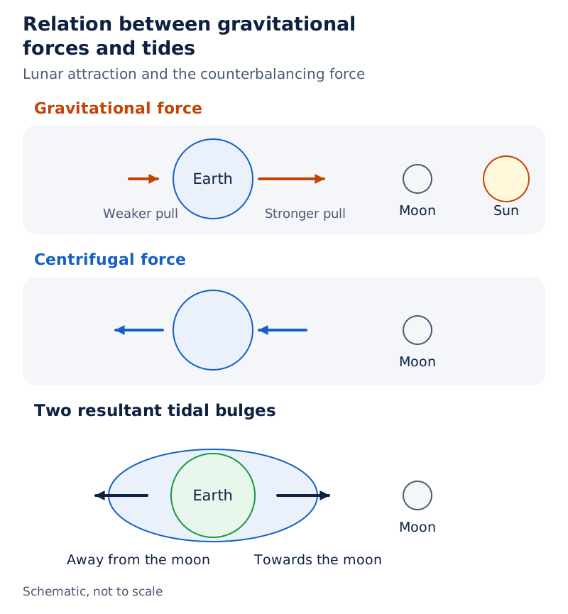
The drawing places the earth to the left of the moon and sun. Separate rows illustrate gravitational and centrifugal forces. A final row shows the earth inside an elongated outline labelled “Two resultant tidal bulges”.
Drawn by One Young India. See Fig. 13.2 in your NCERT textbook
Why does coastal shape matter?
Continental shelves are the shallow submerged margins of continents. Tidal bulges are higher over wide continental shelves and become low when they strike mid-oceanic islands. Bays and estuaries, the coastal mouths of rivers, can magnify tidal intensity.
Funnel-shaped bays greatly change tidal magnitudes. When a tide is channelled between islands or into bays and estuaries, the movement is called a tidal current. Thus, the forces producing tides and the shape of the coast both matter when explaining local tidal conditions.
How are tides classified by frequency and astronomical position?
Tides can be classified by their frequency within a day, or by their height in relation to the positions of the sun, moon and earth. Frequency describes how often tides occur; it should not be confused with tidal range, the difference between high and low water levels.
What are the daily tidal patterns?
| Type | Daily occurrence | Height or distribution |
|---|---|---|
| Semi-diurnal tide | 2 high tides and 2 low tides each day. | The most common pattern; successive high tides or successive low tides are approximately the same height. |
| Diurnal tide | 1 high tide and 1 low tide each day. | Successive high and low tides are approximately of the same height. |
| Mixed tide | Identified by variations in tidal height. | Generally occurs along the west coast of North America and on many Pacific Ocean islands. |
Semi-diurnal means the pattern with two high and two low tides each day. Diurnal identifies the daily pattern with one of each. Mixed tides have variations in height. The word “approximately” matters when describing the heights of successive tides.
How do spring and neap tides differ?
Spring tides occur when the sun, moon and earth lie in a straight line. Tide height is higher. They occur twice a month: once during the full moon period, when the whole illuminated lunar disc is visible, and once during the new moon period, when that illuminated disc is not visible.
Neap tides occur when the sun and moon are at right angles with respect to the earth. Their forces tend to counteract one another. The moon's attraction, though more than twice as strong as the sun's, is diminished by the sun's counteracting pull.
Normally, a seven-day interval separates spring and neap tides. The distinction concerns the relative positions of the bodies and their combined effect on tides. The full moon and new moon are both associated with spring tides.
How do changing distances affect tidal range?
| Position | Meaning and timing | Effect on tides |
|---|---|---|
| Perigee | The moon is closest to the earth, once a month. | Unusually high and low tides; range is greater than normal. |
| Apogee | The moon is farthest from the earth, 2 weeks later. | Lunar gravitational force is limited; tidal ranges are below average. |
| Perihelion | The earth is closest to the sun, around 3 January. | Much greater ranges, with unusually high and low tides. |
| Aphelion | The earth is farthest from the sun, around 4 July. | Tidal ranges are much less than average. |
Ebb is the interval between high and low tide when water level falls. Flow, also called flood, is the interval between low and high tide when water level rises. These terms name stages of the tidal movement rather than different astronomical positions.
What do the Bay of Fundy and the uses of tides show?
Case study: Why is the Bay of Fundy significant?
The world's highest tides occur in the Bay of Fundy in Nova Scotia, Canada. Its tidal bulge is 15 to 16 metres, written as m. There are two high tides and two low tides every day, over roughly a 24-hour period.
A tide therefore comes in within about six hours. A rough estimate uses a rise of 1,440 centimetres, written as cm, divided by six hours. This gives about 240 cm an hour. Keep this rough estimate separate from the stated 15 to 16 m tidal bulge.
The example shows how rapidly rising water can affect a person walking along a beach. Steep cliffs are common alongside beaches there. Someone walking for about an hour before noticing the incoming tide will find the water above their head before returning to the starting point.
Note: “Roughly”, “about” and “rough estimate” are essential to the Bay of Fundy example. The calculation is an approximate illustration of the rise, not a claim that water rises at an identical rate throughout every tide.
How are tides useful?
Tides can be predicted well in advance because the earth-moon-sun positions causing them are known accurately. These predictions help navigators, people directing the passage of vessels, and fishermen plan their activities. Tidal flows are particularly important in navigation.
Tidal heights matter in harbours near rivers and within estuaries. Shallow bars, or sediment ridges, at an entrance can prevent ships and boats from entering. The height of tidal water therefore matters when planning access to such harbours.
Tides also help with desilting, the removal of deposited sediment, and remove polluted water from river estuaries. They can generate electrical power, with examples in Canada, France, Russia and China. Their usefulness thus includes transport, the clearing of estuaries and power generation.
What forces set ocean currents in motion?
Ocean currents resemble river flow within oceans: a regular volume of water follows a definite path and direction. Primary forces initiate movement, while secondary forces influence currents as they flow. The primary forces are heating by solar energy, wind, gravity and the Coriolis force, a deflecting influence on moving water.
How do the primary forces act?
Latitude is angular position north or south of the equator. The Northern and Southern Hemispheres are the halves of the earth north and south of the equator respectively.
- Solar heating: Water expands when heated. Near the equator, the ocean level is about 8 cm higher than in the middle latitudes.
- Gradient: This difference creates a very slight slope, or gradient, and water tends to flow down it.
- Wind and friction: Wind pushes surface water. Friction between the wind and water affects the water body's movement along its course.
- Gravity: Gravity tends to pull water down the pile and creates variation in the gradient.
- Coriolis force: This deflecting influence causes water to move to the right in the Northern Hemisphere and to the left in the Southern Hemisphere.
Large accumulations of water and the flow around them are called gyres; these produce large circular currents in ocean basins.
How do density differences produce vertical movement?
Water with high salinity is denser than water with low salinity. Cold water is denser than warm water. Denser water tends to sink, while relatively lighter water tends to rise. These density differences affect the vertical movement of ocean currents.
Cold water at the poles sinks and slowly moves towards the equator, producing cold-water currents. Warm-water currents travel from the equator along the surface towards the poles. They replace the sinking cold water, linking surface flow with movement into deeper ocean water.
These mechanisms explain different aspects of circulation. Heating creates a very slight surface gradient; wind pushes water; gravity tends to pull it down the pile; the Coriolis force changes its direction. Density differences explain why water tends to sink or rise.
How are ocean currents classified and compared?
Currents can be classified by depth or by temperature. The depth classification distinguishes surface currents from deep water currents. The temperature classification distinguishes currents bringing cold water into warm areas from currents bringing warm water into cold areas.
What distinguishes surface and deep water currents?
| Current category or feature | Numerical detail | Explanation |
|---|---|---|
| Surface currents | About 10 per cent of ocean water; upper 400 m. | These occupy the upper ocean waters. |
| Deep water currents | Other 90 per cent of ocean water. | Movement through ocean basins reflects variations in density and gravity. |
| Currents near the surface | May attain speeds over 5 knots. | Currents are usually strongest near the surface. |
| Currents at depth | Generally less than 0.5 knots. | Deep currents are generally slow. |
| Most currents | Speeds less than or equal to 5 knots. | This describes most currents, rather than an absolute speed limit. |
Deep waters sink into ocean basins at high latitudes, where temperatures are cold enough to increase density. A current's drift means its speed, measured in knots. Its strength also refers to speed: a fast current is considered strong.
A current is usually strongest at the surface and decreases in strength with depth. The statement that most currents move at five knots or less must be kept alongside the possibility of surface speeds above five knots.
Where are warm and cold currents usually found?
| Current type | Low and middle latitudes | Higher latitudes in the Northern Hemisphere |
|---|---|---|
| Cold currents | Usually along west coasts of continents in both hemispheres. | Found along east coasts of continents. |
| Warm currents | Usually along east coasts of continents in both hemispheres. | Found along west coasts of continents. |
Cold currents bring cold water into warm-water areas; warm currents bring warm water into cold-water areas. Coastal position must be considered together with latitude and hemisphere. A rule for low and middle latitudes should not be applied unchanged to higher northern latitudes.
How do maps show the distribution of major ocean currents?
Major currents are greatly influenced by prevailing winds, the winds that dominate a region, and the Coriolis force. Ocean circulation roughly corresponds to atmospheric circulation. In middle latitudes, air circulation over the oceans is mainly anticyclonic, meaning circulation around high atmospheric pressure, more pronounced in the Southern Hemisphere than in the Northern Hemisphere.
Cyclonic circulation is circulation around low atmospheric pressure. At higher latitudes, where wind flow is mostly cyclonic, ocean circulation follows this pattern. In regions of pronounced monsoonal flow, monsoon winds, winds that reverse direction seasonally, influence current movements.
Warm currents from low latitudes tend to move right in the Northern Hemisphere and left in the Southern Hemisphere because of the Coriolis force. Circulation transports heat between latitude belts.
Case study: What contrasts appear in the Pacific Ocean?
The Pacific portion of the current map shows warm and cold flows around the ocean's margins. The Kuroshio Current is shown near eastern Asia and the California Current near western North America. The Peru (Humboldt) Current lies beside western South America.
What the figure shows
Pacific current contrasts
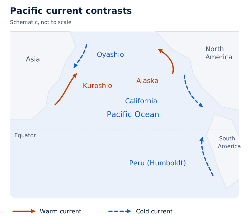
The legend uses solid arrows for warm currents and broken arrows for cold currents. Kuroshio and Alaska are shown as warm currents. California, Oyashio and Peru (Humboldt) are shown as cold currents. Arrows indicate their paths beside the surrounding continents.
Drawn by One Young India. See Fig. 13.3 in your NCERT textbook
What can be identified in the Atlantic and Indian oceans?
What the figure shows
Atlantic and Indian Ocean currents
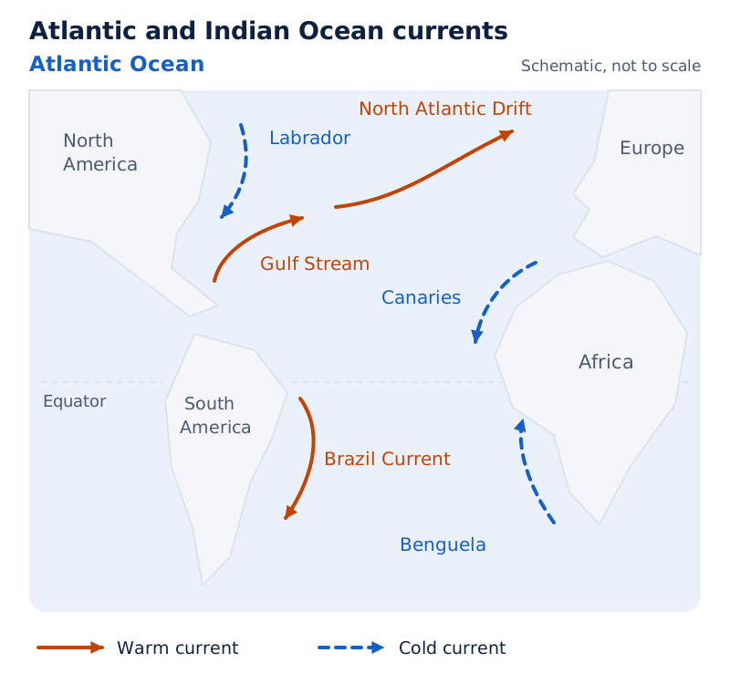
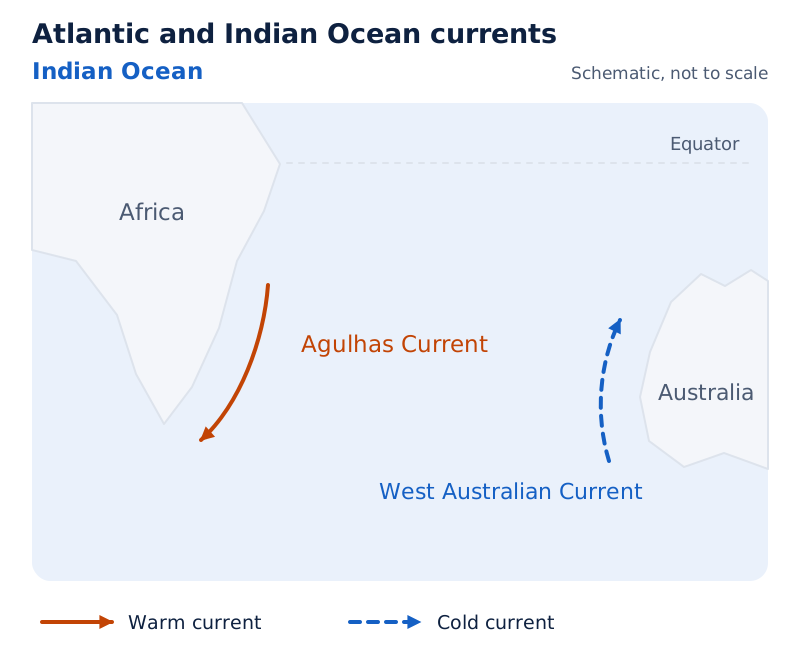
The Atlantic shows the Gulf Stream, North Atlantic Drift and Brazil Current with warm-current arrows, and the Labrador, Canaries and Benguela currents with cold-current arrows. The Indian Ocean shows the Agulhas Current as warm and West Australian Current as cold.
Drawn by One Young India. See Fig. 13.3 in your NCERT textbook
Read the arrow style as well as the current name. The map combines locations, paths and temperature categories. Cold waters from the Arctic and Antarctic circles move towards tropical and equatorial waters, while warm waters from lower latitudes move polewards, carrying heat between regions.
How do ocean currents affect coastal climates and fishing?
Ocean currents influence human activities directly and indirectly. Their redistribution of heat affects coastal temperatures and rainfall. Their mixing also affects conditions supporting fish populations. These effects depend on the position of the coast and on whether nearby waters are warm or cool.
What climatic contrasts occur along coasts?
West coasts in tropical and subtropical latitudes, meaning the belt around the equator and the adjoining belts beyond it, are bordered by cool waters, except close to the equator. Average temperatures are relatively low, with narrow daily and annual temperature ranges. There is fog, but these areas are generally arid, or dry.
West coasts in middle and higher latitudes are bordered by warm waters. These produce a distinct marine climate, meaning a climate influenced by the sea. It has cool summers, relatively mild winters and a narrow annual temperature range.
Warm currents flow parallel to east coasts in tropical and subtropical latitudes, resulting in warm and rainy climates. These areas lie on the western margins of subtropical anticyclones. Thus, similar coast directions can have different climatic associations at different latitudes.
Why are mixing zones important for fishing?
The mixing of warm and cold currents helps replenish oxygen and favours the growth of planktons, the primary food for fish populations. The best fishing grounds of the world exist mainly in these mixing zones.
Keep the causal sequence clear: currents mix, oxygen is replenished and conditions favour plankton growth; planktons supply food for fish. The word “mainly” is essential because this pattern does not locate every fishing ground exclusively within a warm-current and cold-current mixing zone.
Glossary
- Ocean current — A continuous flow of a huge amount of ocean water in a definite direction.
- Wave — Energy moving across the ocean surface while water particles travel in small circles.
- Wave height — The vertical distance from the bottom of a trough to the top of a crest.
- Wave amplitude — One-half of the full vertical height of an ocean wave.
- Wavelength — The horizontal distance between two successive crests of a wave.
- Wave period — The time between successive crests or troughs passing a fixed point.
- Wave frequency — The number of waves passing a given point within one second.
- Tide — The periodical rise and fall of sea level, mainly caused by solar and lunar attraction.
- Surge — A water movement caused by winds or atmospheric pressure changes, without the regularity of tides.
- Spring tide — A higher tide occurring when the sun, moon and earth lie in a straight line.
- Neap tide — A tide associated with the sun and moon at right angles and their forces tending to counteract.
- Ebb — The interval between high and low tide when the water level is falling.
- Flood — The interval between low and high tide when the water level is rising.
- Gyre — A large accumulation of ocean water together with the flow around it.
- Drift — The speed of an ocean current, measured in the unit called knots.
Common errors and misconceptions
- Misconception: Water particles cross the ocean with each passing wave. Correct: Wave energy advances while particles move in small circles. Currents transport water from place to place.
- Misconception: Wave amplitude is the complete crest-to-trough height. Correct: Amplitude is one-half of wave height; wavelength is the horizontal distance between successive crests.
- Misconception: All rises of coastal water are regular tides. Correct: Winds and atmospheric pressure changes cause surges, which are not regular like tides.
- Misconception: Spring tides happen only during the full moon. Correct: They occur twice monthly, during both full moon and new moon periods.
- Misconception: Perigee describes the earth's closest position to the sun. Correct: Perigee concerns the moon's closest position to the earth; perihelion concerns the earth's closest position to the sun.
- Misconception: Cold currents are found along every western coast. Correct: Their usual western-coast distribution applies to low and middle latitudes. Higher northern latitudes have a different pattern.
- Misconception: Five knots is the maximum possible current speed. Correct: Most currents have speeds at or below five knots, but currents near the surface may exceed this.
- Misconception: Every major fishing ground must be a mixing zone. Correct: The best fishing grounds occur mainly where warm and cold currents mix; “mainly” does not mean exclusively.
Exam-style questions with model answers
Q1. A passing wave carries energy across the surface while its water particles travel in small circles. A current carries water continuously in a definite direction. State two differences between these movements. [2 marks]
- A wave transfers energy across the surface, while a current transfers water from one place to another.
- Particles beneath a wave travel in small circles; water in a current follows a definite direction.
Q2. Wave height is measured vertically from trough to crest, amplitude is half that height, and wavelength is the horizontal distance between successive crests. Explain three distinctions using these definitions. [3 marks]
- Wave height measures the full vertical separation between the bottom of a trough and the top of a crest.
- Amplitude is half the wave height, so it is a smaller, related vertical measurement rather than the complete trough-to-crest distance.
- Wavelength measures horizontal spacing between successive crests, so it must be distinguished from both vertical measurements.
Q3. Near the moon, lunar attraction exceeds centrifugal force, which counterbalances gravity. On the far side, lunar attraction is weaker because the distance is greater, and centrifugal force dominates. Explain the formation of two tidal bulges in four points. [4 marks]
- The side facing the moon experiences an attractive pull greater than the counterbalancing centrifugal force.
- The resulting force acts towards the moon, raising water into a tidal bulge on the near side.
- On the opposite side, the greater distance reduces lunar attraction, leaving centrifugal force dominant.
- The resulting force acts away from the moon, producing the second bulge on the far side.
Q4. The Bay of Fundy has two high and two low tides in roughly 24 hours, with an incoming tide taking about six hours. For a rough estimate, use a rise of 1,440 centimetres over six hours. State the pattern, calculate the hourly rise, and identify one limitation of the estimate. [3 marks]
- The pattern contains two high tides and two low tides within roughly one day, with about six hours for the incoming tide.
- The estimated hourly rise is 1,440 centimetres divided by six hours, giving about 240 centimetres an hour.
- This is a rough estimate based on the supplied rise and duration; it does not establish an identical rise during every hour.
Q5. Solar heating expands water, making the equatorial ocean about 8 centimetres higher than middle-latitude water. Wind pushes water through friction, gravity tends to pull water down the pile, and the Coriolis force deflects flow right in the Northern Hemisphere and left in the Southern Hemisphere. Explain five links between these facts and current movement. [5 marks]
- Solar heating expands ocean water, producing an equatorial level about eight centimetres above the level in the middle latitudes.
- The difference in water level creates a very slight gradient, or slope, down which the water tends to flow.
- Wind pushes surface water, and friction between the moving air and the water affects the water body's movement.
- Gravity tends to pull water down from the pile, contributing to variation in the gradient that influences flow.
- The Coriolis force changes the direction of moving water, deflecting it right in the Northern Hemisphere and left in the Southern Hemisphere.
Q6. Spring tides occur with the sun, moon and earth aligned, giving higher tides at full and new moon, twice monthly. During neap tides, the sun and moon are at right angles, and their forces tend to counteract. Normally seven days separate spring and neap tides. Describe the alignment of each type, their tidal effects, the monthly occurrence of spring tides and the usual interval between spring and neap tides. [5 marks]
- Spring tides are associated with the sun, moon and earth lying in a straight line, so their relative alignment is central to the pattern.
- In contrast, neap tides occur when the sun and moon are at right angles with respect to the earth.
- The straight-line arrangement produces higher spring tides, whereas the forces during neap tides tend to counteract one another.
- Spring tides occur twice a month, once during the full moon period and once during the new moon period.
- The interval from a spring tide to a neap tide is normally seven days; this timing should retain the qualification “normally”.
Q7. Cool waters border tropical and subtropical west coasts except near the equator, with relatively low temperatures and generally arid conditions despite fog. Warm waters border middle- and higher-latitude west coasts, giving cool summers and relatively mild winters. Warm currents beside tropical and subtropical east coasts produce warm, rainy climates. Mixing warm and cold currents replenishes oxygen and favours planktons, the primary food for fish; the best fishing grounds occur mainly there. Explain four effects. [4 marks]
- Cool waters beside tropical and subtropical west coasts are associated with relatively low temperatures and generally arid conditions, despite fog, except near the equator.
- Warm waters beside middle- and higher-latitude west coasts produce cool summers and relatively mild winters.
- Warm currents along tropical and subtropical east coasts produce warm and rainy climates.
- Mixing currents replenish oxygen and favour plankton growth, supplying fish food; the best fishing grounds occur mainly in these zones.
Q8. Surface currents comprise about 10 per cent of ocean water in the upper 400 metres; deep currents comprise the other 90 per cent and respond to density and gravity. Currents are usually strongest near the surface and may exceed five knots, a unit of speed. At depth they are generally slower than 0.5 knots; most currents move at five knots or less. Interpret these data in five points. [5 marks]
- Surface currents occupy the upper 400 metres and account for about ten per cent of all ocean water in this depth classification.
- Deep water currents account for the remaining ninety per cent, with their movement through ocean basins affected by density and gravity.
- Currents are usually strongest near the surface, where speeds may rise above five knots; this is a possibility rather than a universal speed.
- At depth, currents are generally slow, with speeds below half a knot, contrasting with the stronger movement usually found near the surface.
- Most currents move at five knots or less, but this does not contradict the statement that some surface speeds may exceed five knots.
Key takeaways
- Waves transfer energy across the ocean surface, while water particles move in small circles and currents carry water along definite paths.
- Wind supplies wave energy; wave height depends on wind strength, duration and the area over which it blows in one direction.
- Lunar attraction and centrifugal force together produce two major tidal bulges, with solar attraction also contributing to tides.
- Daily tidal patterns include semi-diurnal, diurnal and mixed tides; spring and neap tides reflect different sun-moon-earth positions.
- Tidal predictions help navigation and fishing, while tidal flows also assist the removal of sediment and polluted estuarine water.
- Solar heating, wind, gravity and the Coriolis force influence currents, while density differences affect the sinking and rising of water.
- Surface and deep currents differ in depth, while warm and cold currents differ in the temperature of water they bring into an area.
- Currents affect coastal climates, and the world's best fishing grounds occur mainly in zones where warm and cold currents mix.
Test yourself
What is the difference between wave height and amplitude?
Wave height is the vertical trough-to-crest distance; amplitude is one-half of that height.
When does a wave break as it approaches a beach?
It breaks when the water depth becomes less than half its wavelength.
What distinguishes a surge from a tide?
A surge is caused by winds or atmospheric pressure changes and is not regular like a tide.
Which tidal pattern has two high and two low tides each day?
The semi-diurnal pattern has two high and two low tides each day.
How do perigee and apogee differ?
At perigee the moon is closest to the earth; at apogee it is farthest away.
What is the difference between ebb and flood?
Ebb is the falling-water interval from high to low tide; flood is the rising-water interval from low to high tide.
How does the Coriolis force affect ocean currents?
It deflects water to the right in the Northern Hemisphere and to the left in the Southern Hemisphere.
Why are warm-current and cold-current mixing zones useful for fishing?
Mixing helps replenish oxygen and favours plankton growth, providing the primary food for fish populations.
Write about it
Turn a question from this chapter into a paper.
The Writing Studio has a structure guide, a rubric and citation tools for 15 formats, from essays to research papers. Drafting is free with an account. Learnacy Essential adds feedback from an AI writing coach and submission to The OYI Review.
Learnacy Essential is ₹1,499 for the year. Publication depends on review and is not guaranteed.