
Water in the Atmosphere | CBSE Class 11 Geography Notes
On this page
Watch & explore
Start with a few high-quality watches, then dive into the notes below.

This note covers water in the air, measures of atmospheric moisture, changes between water vapour and liquid water, droplets and ice on cold surfaces, clouds near the ground and at height, falling rain and snow, the origins of rainfall, and the distribution of rainfall across the world.
What is humidity, and how is it measured?
Water vapour is water in its gaseous state. Its proportion varies from zero to four per cent by volume of the atmosphere, the air surrounding the earth. It plays an important role in weather phenomena. Atmospheric water occurs in three forms: gaseous, liquid and solid.
Water bodies supply atmospheric moisture through evaporation, the transformation of liquid water into vapour. Plants supply moisture through transpiration, the release of water vapour from plants. Water is continuously exchanged between the atmosphere, oceans and continents.
This exchange also involves condensation, the transformation of water vapour into water, and precipitation, the release of moisture after condensation as liquid or solid particles falling to the earth. These processes connect water in the air with water at the surface.
How do absolute and relative humidity differ?
Definition: Humidity is the water vapour present in the air. Absolute humidity measures its actual amount per unit volume, while relative humidity compares the moisture present with the air's full capacity at a given temperature.
Absolute humidity is the weight of water vapour per unit volume of air, expressed in grams per cubic metre. It differs from place to place on the earth's surface. The ability of air to hold water vapour depends entirely on its temperature.
Relative humidity expresses moisture as a percentage of the full capacity at the given temperature. Changes in temperature change the capacity to retain moisture and also affect relative humidity. Relative humidity is greater over oceans and least over continents.
| Measure | Meaning | Expression |
|---|---|---|
| Absolute humidity | Actual weight of water vapour in a unit volume of air | Grams per cubic metre |
| Relative humidity | Moisture present compared with full capacity at a given temperature | Percentage of full capacity |
What are saturation and dew point?
Saturated air contains moisture to its full capacity at a given temperature. At that temperature, it cannot hold an additional amount of moisture. Dew point is the temperature at which saturation occurs in a given sample of air.
The phrase at a given temperature belongs in explanations of both relative humidity and saturation. A statement about how much moisture air contains is different from a statement about how close it is to its capacity at that temperature.
What controls evaporation from a water surface?
Evaporation changes water from the liquid to the gaseous state and adds water vapour to the atmosphere. Heat is its main cause. Temperature, the moisture already present in the air, and the movement of air help explain the process.
What does latent heat of vaporisation mean?
Latent heat of vaporisation is the heat energy required to convert a unit mass of liquid into vapour without a change in temperature. The definition concerns energy needed for a change of state, and explicitly includes the condition that temperature does not change.
How do temperature, moisture and moving air matter?
- Temperature: An increase in temperature increases the capacity of a parcel, or body, of air to absorb and retain water vapour.
- Existing moisture: If the moisture content is low, the air has the potential to absorb and retain moisture.
- Air movement: Moving air replaces the saturated layer with an unsaturated layer, meaning air that has not reached its full moisture capacity at the given temperature.
Greater movement of air therefore produces greater evaporation. The explanation links the replacement of the air layer to its ability to take in moisture. It does not require a numerical wind speed or a fixed amount of evaporation.
Note: Evaporation adds water vapour to the atmosphere, whereas condensation withdraws it. Keep the direction of the change of state clear: evaporation changes liquid water into vapour; condensation changes vapour into water.
These controls should be considered together. Heating affects the moisture capacity of the air, existing moisture affects its potential to absorb more, and movement replaces the layer above the evaporating surface. Each explains a different part of the same process.
How does cooling produce condensation?
Condensation is caused by loss of heat. When moist air cools, it may reach a level at which its capacity to hold water vapour ceases. Excess water vapour then condenses into liquid water. Cooling is therefore central to the formation of atmospheric droplets.
What are condensation nuclei?
In free air, condensation occurs through cooling around very small particles called hygroscopic condensation nuclei. Hygroscopic means able to absorb water; nuclei are the particles around which condensation occurs. Dust, smoke and salt from the ocean are particularly good nuclei because they absorb water.
Condensation also takes place when moist air contacts a colder object. It may also take place when the temperature is close to the dew point. The amount of cooling and the relative humidity of the air therefore matter.
Under what conditions does condensation occur?
Condensation is influenced by the volume of air, temperature, pressure and humidity. Air pressure is the pressure exerted by air. The following conditions describe ways in which condensation takes place; they are alternatives, rather than successive stages of one required sequence.
- The air temperature falls to the dew point while its volume remains constant.
- Both the volume and the temperature of the air decrease.
- Moisture is added to the air through evaporation.
The most favourable condition for condensation is a decrease in air temperature. Adding moisture and changing air volume also belong in the explanation, but the cooling condition must retain this emphasis.
Diagram
Condensation around a nucleus
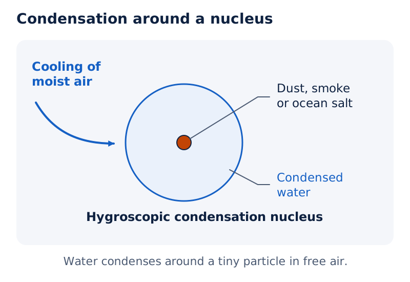
Draw a small particle labelled dust, smoke or ocean salt, with condensed water around it. Add an arrow labelled cooling of moist air. The particle represents a hygroscopic condensation nucleus.
Drawn by One Young India.
Forms of condensation are classified by temperature and location. Condensation occurs with the dew point both below and above the freezing point, the temperature at which water freezes. Surface deposits, clouds near the ground, and clouds at height differ in where the moisture appears.
How do dew and frost form on cold surfaces?
Dew is moisture deposited as water droplets on cooler solid surfaces. Stones, grass blades and plant leaves are examples of these surfaces. The droplets form on objects, rather than on nuclei suspended in the air above the surface.
What conditions favour dew?
The ideal conditions for dew are a clear sky, calm air, high relative humidity, and cold and long nights. The dew point must be above the freezing point. The temperature condition distinguishes dew, a liquid deposit, from frost, a deposit of ice crystals.
Frost forms on cold surfaces when condensation takes place below the freezing point, zero degrees Celsius, with the dew point at or below freezing. Degrees Celsius are units on the Celsius temperature scale. Excess moisture is deposited as minute ice crystals instead of water droplets.
How do the conditions for dew and white frost compare?
The ideal conditions for white frost are the same as those for dew, except that the air temperature must be at or below the freezing point. Both descriptions involve cold surfaces, but their deposits and temperature requirements differ.
| Feature | Dew | Frost |
|---|---|---|
| Form of deposited moisture | Water droplets | Minute ice crystals |
| Place of formation | Cooler solid surfaces such as grass blades | Cold surfaces |
| Dew-point condition | Above the freezing point | At or below the freezing point |
| Ideal surrounding conditions | Clear sky, calm air, high relative humidity, cold and long nights | The same conditions, with air temperature at or below freezing |
Diagram
Dew and frost on surfaces
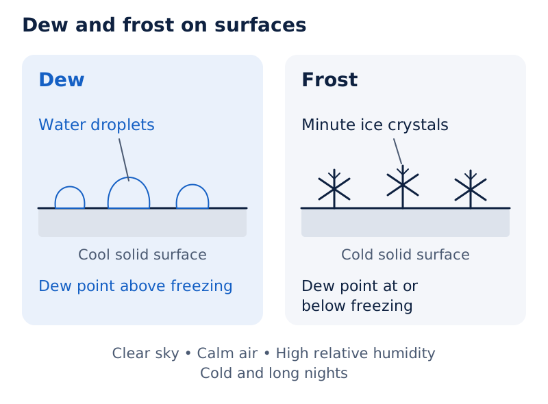
Draw two solid surfaces. Label water droplets on the first as dew and minute ice crystals on the second as frost. Add the respective dew-point conditions: above freezing, and at or below freezing.
Drawn by One Young India.
To distinguish the two deposits, identify the surface, the physical form of the moisture and the dew-point condition. A description of a cold night alone is incomplete because the same broad night-time conditions favour both dew and white frost.
How do fog, mist and smog differ?
Fog is a cloud with its base at or very near the ground. When an air mass, a large body of air with little horizontal variation in temperature and moisture, contains a large quantity of water vapour and its temperature falls suddenly, condensation takes place within it on fine dust particles.
Mist is a near-surface suspension of condensed moisture that limits horizontal visibility to between one and two kilometres. Horizontal visibility means the distance that can be seen along the earth's surface. Fog reduces it to less than one kilometre.
What visibility and moisture differences distinguish them?
In the table, km means kilometre, a unit of distance. The visibility ranges concern how far one can see horizontally. They should be kept separate from the description of moisture surrounding individual nuclei.
| Form | Horizontal visibility | Moisture description |
|---|---|---|
| Fog | Less than 1 km | Drier than mist |
| Mist | Between 1 km and 2 km | More moisture than fog, with a thicker moisture layer around each nucleus |
Mist contains more moisture than fog, with a thicker layer of moisture around each nucleus. Mists are frequent over mountains, where warm air rising up the slopes meets a cold surface. Fogs are prevalent where warm currents of air meet cold currents.
How is smog related to fog?
Smog is fog mixed with smoke. In urban and industrial centres, smoke supplies plenty of nuclei that help fog and mist form. Fog consists of mini clouds in which condensation occurs around dust, smoke and salt particles.
Note: Distinguish the three labels by their defining information: fog has its base at or very near the ground, mist has the stated visibility range and thicker moisture layers around nuclei, and smog is fog mixed with smoke.
How are clouds formed and classified?
A cloud is a mass of minute water droplets or tiny ice crystals produced by condensation of water vapour in free air at considerable elevations. Clouds form at some height above the earth's surface and take different shapes.
The four basic types are cirrus, cumulus, stratus and nimbus, described below. Classification considers height, expanse, density, and transparency or opaqueness. Expanse means extent; transparency and opaqueness concern whether light passes through. Cloud shape alone is therefore not the whole basis of classification.
What distinguishes the four basic cloud types?
Cirrus are thin, detached clouds with a feathery appearance, formed at high altitudes of 8,000 to 12,000 metres. Altitude means height. They are always white. Cumulus look like cotton wool and are generally formed at 4,000 to 7,000 metres.
Cumulus clouds occur in scattered patches and have a flat base. Stratus are layered clouds covering large portions of the sky. They are generally formed by loss of heat or by the mixing of air masses with different temperatures.
Nimbus are black or dark grey clouds forming at middle levels or very near the earth's surface. They are extremely dense and opaque to the sun's rays. Sometimes they are so low that they seem to touch the ground.
Nimbus clouds are shapeless masses of thick vapour. Their description combines colour, density and position. In comparison, cirrus are identified by their high altitude and feathery appearance, cumulus by their cotton-wool appearance and flat base, and stratus by their layered form.
| Cloud type | Position or extent | Appearance |
|---|---|---|
| Cirrus | 8,000 to 12,000 metres | Thin, detached, feathery and always white |
| Cumulus | Generally 4,000 to 7,000 metres | Cotton-wool appearance, scattered patches and flat base |
| Stratus | Layers covering large portions of the sky | Layers covering large portions of the sky |
| Nimbus | Middle levels or very near the surface | Black or dark grey, dense, opaque and shapeless |
How do combinations of cloud types form height groups?
Combinations of the four basic types can give rise to further cloud types. The names in the table are grouped by height or by extensive vertical development, meaning development through height. These groups are distinct from the four basic descriptive categories.
| Group | Cloud types in the group |
|---|---|
| High clouds | Cirrus, cirrostratus and cirrocumulus |
| Middle clouds | Altostratus and altocumulus |
| Low clouds | Stratocumulus and nimbostratus |
| Clouds with extensive vertical development | Cumulus and cumulonimbus |
What the figure shows
Photograph of scattered clouds
This photograph shows bright, rounded cloud patches against a darker sky, with land below. Some cloud bases look relatively flat.
See Fig. 10.1 in your NCERT textbook
What the figure shows
Photograph of dark cloud cover
This photograph shows broad dark cloud cover, a brighter opening near the centre, distant hills and a water surface below.
See Fig. 10.2 in your NCERT textbook
What forms can precipitation take?
Precipitation is the release of moisture after water vapour condenses. It can occur in liquid or solid form. Continuous condensation in free air allows condensed particles to grow until the resistance of the air cannot hold them against gravity, the force pulling them towards the earth.
How does condensed moisture reach the ground?
- Water vapour condenses in free air, producing condensed particles.
- Continuous condensation allows those particles to increase in size.
- The resistance of the air fails to hold them against the force of gravity.
- The particles fall to the earth's surface as precipitation, in liquid or solid form.
Rainfall is precipitation in the form of water. Snowfall occurs as fine flakes of snow when the temperature is below zero degrees Celsius. Moisture is released as hexagonal crystals, meaning six-sided crystals, which form the snowflakes.
What distinguishes sleet from hail?
Sleet consists of frozen raindrops and refrozen melted snow-water. It forms when an above-freezing air layer overlies a subfreezing layer near the ground. Subfreezing means below the freezing point. Raindrops leaving warmer air encounter colder air below and solidify.
The resulting small ice pellets are not bigger than the raindrops from which they form. The order of the air layers matters: warmer air is above, with colder air below near the ground. The droplets encounter the lower cold layer while falling.
Hailstones are small, rounded, solid pieces of ice reaching the earth's surface. Sometimes raindrops released by clouds solidify as they pass through colder layers. Hailstones contain several concentric layers of ice, meaning layers arranged one around another.
| Form | What reaches the surface | Formation detail |
|---|---|---|
| Rain | Liquid water | Moisture falls in liquid form |
| Snow | Fine flakes | Hexagonal ice crystals form flakes below zero degrees Celsius |
| Sleet | Small ice pellets | Raindrops or melted snow-water freeze in colder air below |
| Hail | Rounded solid pieces of ice | Rainwater passes through colder layers; hailstones have concentric ice layers |
Sleet and hail are limited in occurrence and sporadic in both time and space. Sporadic means occurring irregularly. This qualification distinguishes their occurrence from a claim that they happen everywhere or accompany every rainfall event.
How do convectional and cyclonic rainfall develop?
Rainfall is classified by origin into three main types: convectional, caused by heated air rising; orographic or relief, caused by air being forced over mountains; and cyclonic or frontal, associated with cyclones or fronts. A front is a boundary between different air masses.
A cyclone is a low-pressure system with circulating winds. These names classify the origin of rainfall, whereas rain, snow, sleet and hail identify forms of precipitation. The two classifications answer different questions about atmospheric moisture.
What is the sequence in convectional rain?
Convection currents are rising movements of heated air. When air is heated, it becomes light and rises. Its expansion and loss of heat as it rises lead to condensation and the formation of cumulus clouds.
- Air is heated, becomes light and begins to rise in convection currents.
- As the air rises, it expands and loses heat.
- Condensation takes place and cumulus clouds form.
- Heavy rainfall occurs with thunder and lightning, but it does not last long.
Where and when is this rain common?
Convectional rain is common in summer or in the hotter part of the day. It is very common in equatorial regions, the regions around the equator, and in continental interiors, particularly in the northern hemisphere, the half of the earth north of the equator.
The equator is the line dividing the earth into northern and southern hemispheres. The distribution of convectional rainfall connects the heating and rising of air with regions and times in which this type of rain is common.
Diagram
Convectional rainfall
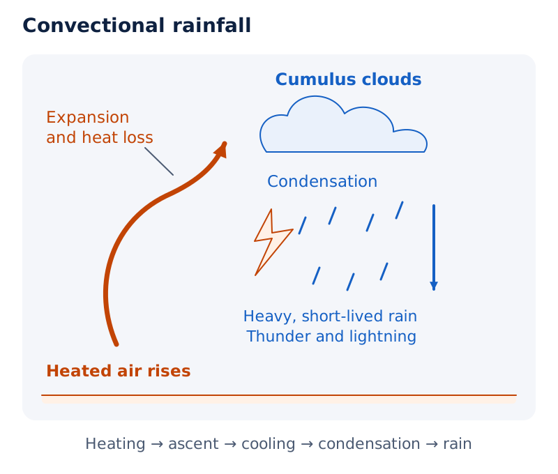
Draw an upward arrow for heated air rising, followed by labels for expansion, heat loss and condensation. Show cumulus clouds above and falling rain below. Label the rain heavy but short-lived, with thunder and lightning.
Drawn by One Young India.
How do fronts produce cyclonic rainfall?
Extra tropical cyclones are systems developing in middle and high latitudes beyond the tropics, the warm belt around the equator. They have a warm front and a cold front. Fronts cause air to rise, form clouds and produce precipitation.
A warm front is the contact zone where warm air moves towards a cold air mass. Warm air glides over cold air, and a sequence of clouds appears ahead of the warm front, causing precipitation.
A cold front is the contact zone where cold air moves towards a warm air mass. It approaches warm air from behind and pushes it upwards. Cumulus clouds develop along the cold front.
The cold front moves faster than the warm front and ultimately overtakes it. The warm air becomes completely lifted. The front is then occluded, meaning the warm air has been lifted above the land surface, and the cyclone dissipates, or dies away.
Why do mountains produce orographic rain and a rain shadow?
Orographic rainfall, also called relief rainfall, develops when a saturated air mass encounters a mountain and is forced to ascend. As the air rises, it expands, its temperature falls, and its moisture condenses. The mountain provides the barrier that forces the ascent.
What happens on the windward slope?
The windward slope is the side facing the incoming wind. A chief characteristic of orographic rain is that this slope receives greater rainfall. The sequence links forced ascent to expansion, cooling and condensation, rather than beginning with surface heating as convectional rain does.
- A saturated air mass reaches a mountain and is forced to rise.
- The rising air expands, its temperature falls, and moisture condenses.
- Rain falls on the windward side, which receives greater rainfall.
- After crossing to the other slope, the air descends and its temperature rises.
- The descending air's moisture capacity increases, leaving the leeward slopes rainless and dry.
Why is the leeward side drier?
The leeward slope is the slope on the other side from the incoming wind. As air descends there, its temperature rises and its capacity to take in moisture increases. The area on the leeward side receiving less rainfall is called a rain-shadow area.
Diagram
Orographic rainfall and rain shadow
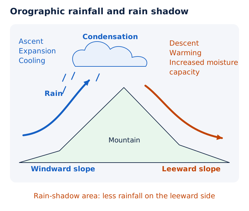
Draw a mountain with an arrow ascending the windward slope and another descending the leeward slope. Label ascent, expansion, cooling, condensation and rain on the windward side. Label descent, warming and increased moisture capacity on the leeward side.
Drawn by One Young India.
The contrast between the slopes concerns both air movement and rainfall. Windward ascent cools the air; leeward descent warms it. Where mountains run parallel to a coast, greater rain falls on the coastal plain and windward side, decreasing towards the leeward side.
How is rainfall distributed across the world?
Places receive different amounts of rainfall during a year and in different seasons. Annual rainfall means rainfall over a year. Its total and its seasonal distribution describe different aspects of a place's rainfall pattern.
What are the broad geographical patterns?
In general, rainfall decreases steadily from the equator towards the poles, the earth's northern and southern ends. Coastal areas receive greater rainfall than continental interiors. Rainfall is greater over oceans than over landmasses because oceans are great sources of water.
Latitude measures angular distance north or south of the equator. In the ranges below, the symbol ° means degrees, while N and S mean north and south. The eastern and western sides of continents show different patterns in different latitude bands.
Westerlies are winds blowing from the west.
| Latitude band | Coastal rainfall pattern | Direction of decrease |
|---|---|---|
| 35° to 40° N and S | Heavier rainfall on eastern coasts | Rainfall decreases towards the west |
| 45° to 65° N and S | Rainfall first received on western continental margins due to westerlies | Rainfall decreases towards the east |
Westerlies explain the western-margin pattern between 45° and 65° north and south. The contrast between the two latitude bands prevents treating either eastern or western coasts as wetter in every part of the world.
What are the major annual precipitation regimes?
A precipitation regime is a pattern of precipitation. The following groups use total annual amounts. Here, cm means centimetres, a unit of length used to express precipitation depth; per annum means per year.
The equatorial belt is the belt around the equator. Tropical lands lie in the warm belt around it; temperate lands lie between tropical and polar regions. Monsoon land refers to land influenced by seasonally reversing winds. High latitudes are latitudes towards the poles.
| Annual amount | Regions | Description |
|---|---|---|
| Over 200 cm | Equatorial belt; windward mountain slopes along western coasts in the cool temperate zone; coastal areas of monsoon land | Heavy rainfall |
| 100 to 200 cm | Interior continental areas | Moderate rainfall |
| 50 to 100 cm | Central tropical land; eastern and interior temperate lands | Rainfall within this annual range |
| Less than 50 cm | Rain-shadow zones in continental interiors and high latitudes | Very low rainfall |
Continental coastal areas also receive moderate rainfall. The broad equator-to-pole trend should therefore be read alongside the effects of coastlines, continental interiors, winds and mountain slopes. A general global pattern does not replace the more specific regional descriptions.
Why does the seasonal distribution matter?
Seasonal distribution means how rainfall is spread through the seasons. It is important in judging the effectiveness of rainfall. An annual total describes the amount received, whereas seasonal distribution describes its timing during the year.
Some regions receive rainfall evenly throughout the year. Examples are the equatorial belt and the western parts of cool temperate regions. These examples concern the spread of rainfall through the year, rather than a claim that every region has the same rainfall each season.
Case study: What characterises rainfall in the equatorial belt?
The equatorial belt receives heavy rainfall of over 200 cm per annum, distributed evenly throughout the year. Convectional rain is very common in equatorial regions, linking this regional example with the process of heated air rising, expanding and cooling.
Condensation forms cumulus clouds, followed by heavy rain with thunder and lightning. Individual convectional showers do not last long. Their short duration and the even annual distribution describe different aspects of rainfall: a shower and the seasonal pattern.
Diagram
Equatorial rainfall pattern
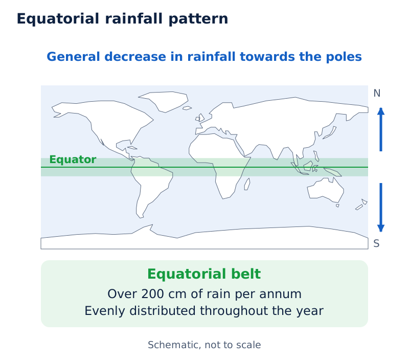
On a world outline, mark the equator and label the equatorial belt: over 200 cm of rain per annum, evenly distributed throughout the year. Add arrows towards the poles labelled general decrease in rainfall.
Drawn by One Young India.
Case study: How do western margins in cool temperate regions receive rainfall?
Between 45° and 65° N and S, westerlies bring rainfall first to western continental margins, with rainfall decreasing eastwards. Windward mountain slopes along western coasts in the cool temperate zone receive over 200 cm per annum.
Where mountains run parallel to the coast, rainfall is greater on the coastal plain and windward side and decreases towards the leeward side. Western parts of cool temperate regions also have rainfall distributed evenly throughout the year.
Diagram
Rainfall across two latitude bands
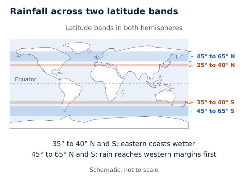
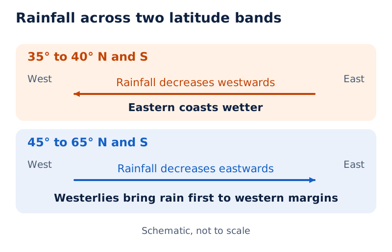
Mark 35° to 40° N and S on a world outline; label eastern coasts wetter, with rainfall decreasing westwards. Mark 45° to 65° N and S; label western margins receiving rain first from westerlies, with rainfall decreasing eastwards.
Drawn by One Young India.
Glossary
- Humidity — Water vapour present in the air, expressed quantitatively through measures such as absolute and relative humidity.
- Absolute humidity — Actual weight of water vapour per unit volume of air, expressed in grams per cubic metre.
- Relative humidity — Percentage of moisture present compared with the air's full moisture capacity at a given temperature.
- Saturated air — Air containing moisture to its full capacity at a given temperature and unable to hold additional moisture then.
- Dew point — Temperature at which saturation occurs in a given sample of air.
- Evaporation — Process that transforms liquid water into water vapour, with heat as its main cause.
- Latent heat of vaporisation — Heat required to convert a unit mass of liquid into vapour without a change in temperature.
- Condensation — Transformation of water vapour into water, caused by loss of heat.
- Condensation nuclei — Very small particles, including dust, smoke and ocean salt, around which condensation occurs in free air.
- Dew — Moisture deposited as water droplets on cooler solid surfaces, with the dew point above freezing.
- Frost — Minute ice crystals deposited on cold surfaces when the dew point is at or below freezing.
- Fog — Cloud based at or very near the ground, reducing horizontal visibility to less than one kilometre.
- Precipitation — Release of moisture after condensation, falling to the earth in liquid or solid form.
- Sleet — Frozen raindrops and refrozen melted snow-water reaching the ground as small ice pellets.
- Rain-shadow area — Area on the leeward side of a mountain that receives less rainfall.
Common errors and misconceptions
- Misconception: Absolute and relative humidity are two names for the same measurement. Correct: Absolute humidity measures water-vapour weight per unit volume; relative humidity compares moisture with full capacity at a given temperature.
- Misconception: Saturation is independent of temperature. Correct: Saturated air holds moisture to its full capacity at a given temperature, and the air's moisture-holding capacity depends entirely on temperature.
- Misconception: Dew and frost both consist of water droplets. Correct: Dew consists of water droplets, whereas frost consists of minute ice crystals. Their dew-point conditions differ across the freezing point.
- Misconception: Fog and smog are interchangeable labels. Correct: Fog is a cloud based at or near the ground; smog is fog mixed with smoke, which supplies condensation nuclei.
- Misconception: Cirrus and cumulus clouds have the same stated height. Correct: Cirrus form at 8,000 to 12,000 metres; cumulus are generally formed at 4,000 to 7,000 metres.
- Misconception: Every cloud droplet immediately falls as rain. Correct: Condensed particles grow through continuous condensation and fall when air resistance cannot hold them against gravity; precipitation can be liquid or solid.
- Misconception: The leeward mountain slope receives greater orographic rainfall. Correct: The windward slope receives greater rainfall; descending air on the leeward slope warms and has an increased capacity to take in moisture.
- Misconception: Rainfall decreases in the same east-west direction at all latitudes. Correct: It decreases westwards between 35° and 40° N and S, but eastwards between 45° and 65° N and S.
Exam-style questions with model answers
Q1. Define absolute humidity and relative humidity. Include the unit or form of expression for each. [2 marks]
- Absolute humidity is the actual weight of water vapour per unit volume of air, expressed in grams per cubic metre.
- Relative humidity is the percentage of moisture present compared with the air's full capacity at a given temperature.
Q2. Explain three factors that affect evaporation: air temperature, existing moisture content and air movement. [3 marks]
- An increase in temperature increases the ability of a parcel of air to absorb and retain moisture. Heat is the main cause of evaporation.
- When air has a low moisture content, it has the potential to absorb and retain moisture, allowing water vapour to be added to it.
- Moving air replaces a saturated layer with an unsaturated layer. Greater air movement therefore leads to greater evaporation.
Q3. Compare dew and frost under four headings: physical form, surface of formation, dew-point condition and ideal conditions. Include similarities where applicable. [4 marks]
- Dew consists of water droplets. Frost consists of minute ice crystals deposited instead of liquid droplets.
- Dew forms on cooler solid surfaces such as stones, grass blades and leaves. Frost also forms on cold surfaces.
- Dew requires a dew point above freezing. Frost forms when the dew point is at or below the freezing point.
- Dew is favoured by clear skies, calm air, high relative humidity, and cold, long nights. White frost has the same ideal conditions except that air temperature must be at or below freezing.
Q4. Describe cirrus, cumulus, stratus and nimbus clouds, giving one separate description of each type. Include the stated height ranges for cirrus and cumulus. [4 marks]
- Cirrus form at 8,000 to 12,000 metres. They are thin, detached and feathery, and are always white.
- Cumulus generally form at 4,000 to 7,000 metres. They resemble cotton wool, occur in scattered patches and have flat bases.
- Stratus are layered clouds covering large portions of the sky. They generally form through heat loss or the mixing of air masses with different temperatures.
- Nimbus are black or dark grey, extremely dense and opaque. They form at middle levels or near the surface, sometimes appearing to touch the ground.
Q5. Explain convectional rainfall in five points, covering its origin, rising-air changes, cloud formation, rainfall characteristics, and common times and regions. [5 marks]
- Convectional rainfall begins when air is heated. The heated air becomes light and rises in convection currents, beginning the upward movement that leads to rain.
- As this air rises, it expands and loses heat. Expansion and cooling follow the initial heating and upward movement of the air.
- Condensation then takes place in the rising air, and cumulus clouds form. These clouds are associated with the development of convectional rainfall.
- The rainfall is heavy and accompanied by thunder and lightning, but it does not last long. Its heavy character should therefore be distinguished from its short duration.
- It is common in summer or the hotter part of the day, and very common in equatorial regions and continental interiors, particularly in the northern hemisphere.
Q6. A saturated air mass encounters a mountain, rises over its windward slope, and descends the leeward slope. Explain the resulting rainfall contrast in five stages. [5 marks]
- The mountain acts as a barrier to the saturated air mass, forcing it to ascend the windward slope. This is the beginning of orographic or relief rainfall.
- As the air rises, it expands and its temperature falls. The cooling causes moisture in the saturated air to condense.
- Rain falls on the windward side. Greater rainfall on the windward slope is the chief characteristic of this type of rainfall.
- After giving rain and reaching the other slope, the air descends. Its temperature rises during descent, increasing its capacity to take in moisture.
- The leeward slopes remain rainless and dry. The leeward area receiving less rainfall is called the rain-shadow area, contrasting with the wetter windward slope.
Q7. Describe six features of world rainfall distribution: the equator-to-pole trend, coastal-interior contrast, ocean-land contrast, the 35° to 40° N and S band, the 45° to 65° N and S band, and the effect of coastal mountains. [6 marks]
- In general, rainfall decreases steadily as one moves from the equator towards the poles. This describes the broad global trend in rainfall distribution.
- Coastal areas of the world receive greater amounts of rainfall than the interiors of continents, creating a coast-to-interior contrast.
- Rainfall is greater over oceans than over landmasses because oceans are great sources of water for moisture in the atmosphere.
- Between 35° and 40° north and south of the equator, rainfall is heavier on eastern coasts and decreases towards the west.
- Between 45° and 65° north and south, westerlies bring rainfall first to western continental margins, and rainfall decreases towards the east.
- Where mountains parallel a coast, rainfall is greater on the coastal plain and windward side, and decreases towards the leeward side.
Q8. Distinguish sleet from hail by describing the formation and physical form of each. [2 marks]
- Sleet is frozen raindrops or refrozen melted snow-water, forming small pellets as precipitation enters colder air below warmer air.
- Hail consists of rounded solid ice pieces formed as rainwater passes through colder layers; hailstones have several concentric ice layers.
Key takeaways
- Water vapour varies from zero to four per cent by atmospheric volume; atmospheric water occurs in gaseous, liquid and solid forms.
- Absolute humidity measures water-vapour weight per unit volume, while relative humidity compares moisture with capacity at a given temperature.
- Evaporation adds water vapour to air; condensation withdraws it, with falling temperature the most favourable condition for condensation.
- Dew consists of droplets on cooler surfaces; frost consists of minute ice crystals when the dew point is at or below freezing.
- Fog is a cloud at or near ground level; smoke supplies condensation nuclei and mixes with fog to form smog.
- Cirrus, cumulus, stratus and nimbus are the four basic cloud types, distinguished using height, expanse, density and transparency or opaqueness.
- Convectional rain follows heating and rising air; orographic rain follows forced mountain ascent, with greater rainfall on the windward slope.
- World rainfall varies with latitude, coasts, oceans, continental interiors and mountain slopes; its seasonal distribution matters alongside the annual amount.
Test yourself
What does dew point mean?
It is the temperature at which saturation occurs in a given sample of air.
Why does greater air movement increase evaporation?
Movement replaces the saturated layer with an unsaturated layer that can absorb and retain more moisture.
Which particles are particularly good condensation nuclei, and why?
Dust, smoke and salt from the ocean are particularly good nuclei because they absorb water.
How does the dew-point condition differ between dew and frost?
Dew requires a dew point above freezing, while frost forms with the dew point at or below freezing.
What horizontal visibility ranges distinguish fog and mist?
Fog reduces horizontal visibility to less than one kilometre; mist limits it to between one and two kilometres.
Which cloud types belong to the group with extensive vertical development?
Cumulus and cumulonimbus belong to the group of clouds with extensive vertical development.
What happens to air temperature and moisture capacity on the leeward slope?
Descending air becomes warmer, and its capacity to take in moisture increases, leaving the leeward slope dry.
Which regions receive rainfall evenly throughout the year?
The equatorial belt and the western parts of cool temperate regions have rainfall distributed evenly throughout the year.
Write about it
Turn a question from this chapter into a paper.
The Writing Studio has a structure guide, a rubric and citation tools for 15 formats, from essays to research papers. Drafting is free with an account. Learnacy Essential adds feedback from an AI writing coach and submission to The OYI Review.
Learnacy Essential is ₹1,499 for the year. Publication depends on review and is not guaranteed.