
World Climate and Climate Change | CBSE Class 11 Geography Notes
On this page
Watch & explore
Start with a few high-quality watches, then dive into the notes below.

This note covers climate classification, Koeppen’s climatic groups and letter codes, tropical and dry climates, warm temperate and cold climates, evidence of past climate change, astronomical and terrestrial causes, the greenhouse effect, greenhouse gases, global temperature records and international action.
How is world climate classified?
Climate means the characteristic weather conditions of a region over a long period. Classification organises information about world climates into smaller units, making their description, comparison and analysis easier.
The three broad approaches are empirical, genetic and applied classification. Their difference lies in the basis used to organise climates: observations, causes or a particular purpose.
| Approach | Basis of classification |
|---|---|
| Empirical | Observed data, particularly temperature and precipitation |
| Genetic | The causes responsible for climates |
| Applied | A specific purpose for which climates are classified |
What information does Koeppen use?
V. Koeppen developed an empirical classification using mean annual and mean monthly temperature and precipitation. A mean is an average. Precipitation means water falling from the atmosphere, including rain and snow.
Koeppen identified a close relationship between the distribution of vegetation and climate. He selected particular temperature and precipitation values, related them to vegetation distribution, and used them to distinguish climates. The scheme was developed in 1918 and modified over time.
Four of its five major groups are based on temperature and one on precipitation. The letters A, C, D and E identify humid climates, while B identifies dry climates. Here, humid refers to moisture-bearing conditions; dry refers to conditions with inadequate moisture.
Definition: An empirical climate classification groups climates using observed data. Koeppen’s scheme uses temperature and precipitation data and relates selected values to the distribution of vegetation.
This connection between climate and vegetation is central to the scheme. The classification is not genetic merely because vegetation and climate are related: its grouping criteria are measured climatic values rather than the causes that produce the climates.
What do Koeppen’s groups and letter codes mean?
Capital letters identify the major climatic groups. Temperature values below use °C, meaning degrees Celsius. Potential evaporation means the evaporation possible if sufficient water is available; group B is identified by potential evaporation exceeding precipitation.
| Group and meaning | Defining characteristic |
|---|---|
| A: tropical | Average temperature of the coldest month is 18°C or higher |
| B: dry | Potential evaporation exceeds precipitation |
| C: warm temperate, or mid-latitude | Average temperature of the coldest month is higher than minus 3°C but below 18°C |
| D: cold snow forest | Average temperature of the coldest month is minus 3°C or below |
| E: cold | Average temperature for all months is below 10°C |
How do additional letters refine a group?
Small letters describe rainfall seasonality and temperature characteristics. The letter f means no dry season, m means monsoon climate, w means a winter dry season, and s means a summer dry season. The letters a, b, c and d refer to degrees of temperature severity.
In dry climates, the capital letter S means steppe or semi-arid climate, and W means desert climate. Semi-arid means partly dry conditions, intermediate between humid conditions and desert aridity. Each full code is defined with its climatic type below.
The group and the additional letters must be read together. A broad group gives the general climatic category, while the following letters help distinguish conditions within it. Rainfall seasonality is particularly useful for separating climates that are warm but have different dry seasons.
Note: Group A uses the coldest month’s average temperature. Group E uses average temperatures for all months. Group B uses the relationship between potential evaporation and precipitation, rather than a single temperature boundary.
How do tropical humid climates differ?
Tropical humid climates, group A, occur between the Tropic of Cancer and the Tropic of Capricorn. The Inter Tropical Convergence Zone, abbreviated ITCZ, is the zone where tropical winds converge. It helps make this belt hot and humid.
The annual temperature range, the difference between the warmest and coldest monthly mean temperatures, is very low, while annual rainfall is high. Three types are distinguished by the distribution of rainfall through the year.
What characterises tropical wet climate?
Af means tropical wet climate, with no dry season. It occurs near the equator in the Amazon Basin of South America, western equatorial Africa and the islands of the East Indies. Significant rainfall falls in every month as afternoon thundershowers.
Temperatures are uniformly high, with a negligible annual range. The daily maximum is around 30°C and the minimum around 20°C. Tropical evergreen forests have dense canopy cover, meaning a closely packed upper layer of foliage, and large biodiversity, meaning variety of living organisms.
What distinguishes monsoon and wet-and-dry climates?
Am means tropical monsoon climate, with a short dry season. It occurs over the Indian subcontinent, northeastern South America and northern Australia. Heavy rain occurs mostly in summer; winter is dry. Monsoon refers here to the seasonal climatic pattern associated with changing winds and rainfall.
Aw means tropical wet and dry climate, with winter dryness. Extensive areas lie north and south of the Amazon forest in Brazil and adjoining Bolivia and Paraguay, in Sudan and south of Central Africa.
Annual rainfall in Aw is considerably less than in Af and Am and is also variable. The wet season is shorter, the dry season longer and drought more severe. Temperature remains high throughout the year.
The diurnal temperature range, the difference between daily maximum and minimum temperatures, is greatest during the dry season. Deciduous forests, whose trees shed leaves seasonally, and grasslands with trees occur in this climate.
Diagram
Tropical climate locations
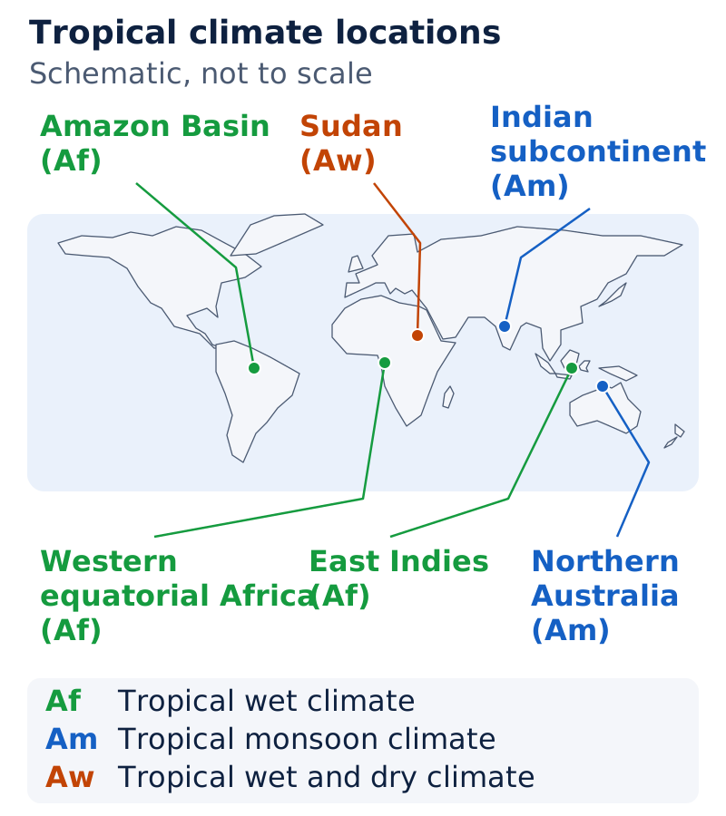
On a world outline map, label the Amazon Basin, western equatorial Africa and East Indies as Af locations. Label the Indian subcontinent and northern Australia for Am, and Sudan for Aw. Use labelled locations rather than invented regional boundaries.
Drawn by One Young India.
Why do dry climates occur, and how do steppe and desert differ?
Dry climates, group B, have very low rainfall, inadequate for plant growth. They extend across a broad belt from 15° to 60° north and south of the equator. Latitude is angular distance north or south of the equator; ° denotes degrees.
Which conditions favour dryness?
At low latitudes, from 15° to 30°, dry climates occur within the subtropical high, a belt of high atmospheric pressure. Subsidence, meaning sinking air, and temperature inversion, meaning temperature increasing with height, do not produce rainfall in these conditions.
On western continental margins beside cold ocean currents, particularly the west coast of South America, dry climates extend farther towards the equator and reach coastal land. A current is a moving stream of ocean water.
At middle latitudes, from 35° to 60°, dry climates are confined to continental interiors where moisture-bearing winds from the sea do not reach, and to areas often surrounded by mountains.
| Full code and type | Latitudinal belt |
|---|---|
| BSh: subtropical steppe | 15° to 35° |
| BWh: subtropical desert | 15° to 35° |
| BSk: mid-latitude steppe | 35° to 60° |
| BWk: mid-latitude desert | 35° to 60° |
Why is steppe rainfall especially important?
Subtropical steppe lies in the transition between humid and dry climates. It receives slightly more rainfall than the desert, enough for sparse grasslands. Rainfall is highly variable in both climates, but its variability affects steppe life much more, more often causing famine.
Desert rain falls as short, intense thundershowers and is ineffective in building soil moisture. Fog is common in coastal deserts bordering cold currents. Maximum summer temperatures are very high, and both annual and diurnal temperature ranges are high.
Note: The difference is slightly more rainfall in steppe regions, not abundant rainfall. Sparse grassland can grow, but rainfall variability remains a major feature of the climate.
How do the warm temperate climates compare?
Warm temperate climates, group C, occur from 30° to 50° latitude, mainly along eastern and western continental margins. They generally have warm summers and mild winters. Their four types differ in rainfall seasonality, location and temperature.
Which types have a dry season?
Cwa means humid subtropical climate with dry winters and hot summers. It occurs poleward of the tropics, meaning towards the poles, mainly in the North Indian plains and South China interior plains. It resembles Aw except that winter temperature is warm.
Cs means Mediterranean climate. It occurs around the Mediterranean Sea and on western continental coasts between 30° and 40° latitude. Examples include Central California, Central Chile and the coasts of southeastern and southwestern Australia.
These regions experience subtropical high pressure in summer and westerly winds, winds blowing from the west, in winter. Consequently, summers are hot and dry, while winters are mild and rainy.
Which types receive rain throughout the year?
Cfa means humid subtropical climate with no dry season and mild winters. It occurs on eastern continental parts in subtropical latitudes. Air masses, large bodies of air with broadly similar properties, are generally unstable and cause rainfall throughout the year.
Locations include the eastern United States, southern and eastern China, southern Japan, northeastern Argentina, coastal South Africa and eastern Australia. Summer thunderstorms and winter frontal precipitation, rain or snow associated with the boundary between air masses, are common. Daily temperature range is small.
Cfb means marine west coast climate. It lies poleward of Mediterranean regions on western coasts. Examples include northwestern Europe, North America’s west coast north of California, southern Chile, southeastern Australia and New Zealand.
Marine influence, meaning the influence of the sea, moderates temperatures and makes winter warmer than expected for the latitude. Annual and daily temperature ranges are small. Rain falls throughout the year.
| Type | Summer temperature | Winter temperature | Annual precipitation |
|---|---|---|---|
| Cs | Monthly average around 25°C | Monthly average below 10°C | 35 to 90 centimetres (cm) |
| Cfa | Mean monthly around 27°C | Mean monthly 5°C to 12°C | 75 to 150 cm |
| Cfb | Mean 15°C to 20°C | Mean 4°C to 10°C | 50 to 250 cm |
Diagram
Contrasting coastal climates
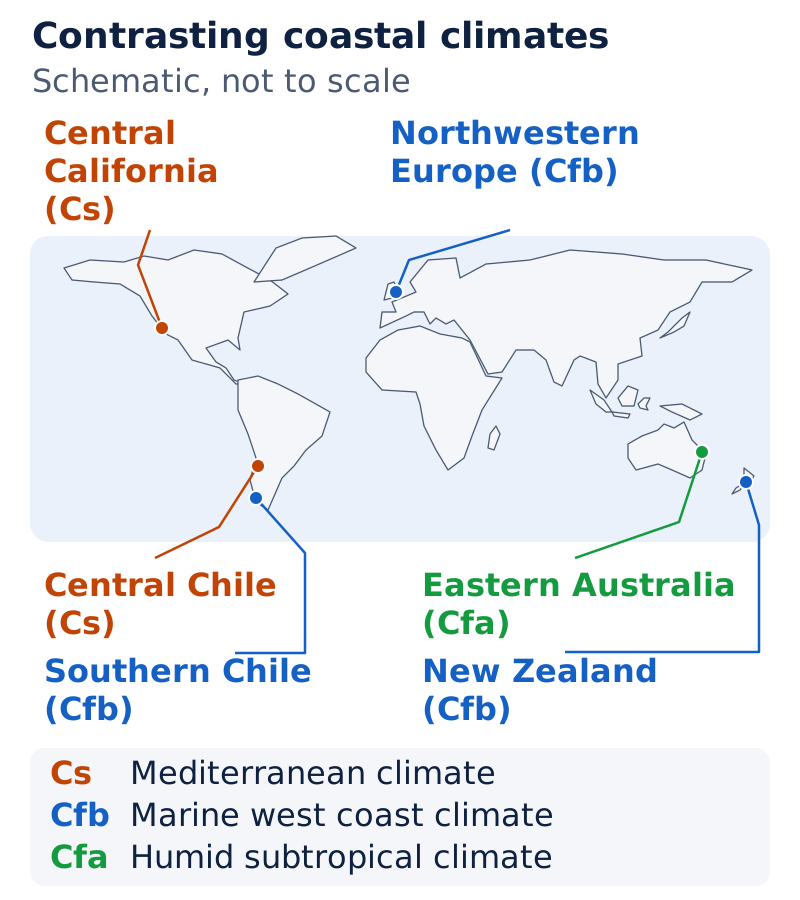
Label Central California and Central Chile for Mediterranean climate. Label northwestern Europe, southern Chile and New Zealand for marine west coast climate. Mark eastern Australia as a humid subtropical location. Use distinct labels for the named climatic types.
Drawn by One Young India.
What distinguishes cold snow forest and polar climates?
Cold snow forest climates, group D, occupy large continental areas of Europe, Asia and North America between 40° and 70° north. Winter severity becomes more pronounced at higher latitudes. Two types differ in their winter moisture conditions.
How do Df and Dw differ?
Df means cold climate with humid winters, also called humid continental climate. It occurs poleward of marine west coast and mid-latitude steppe climates. Winters are cold and snowy, the frost-free season is short and annual temperature ranges are large.
Weather changes are abrupt and short, and winters become more severe poleward. The frost-free season is the period without freezing conditions that produce frost. Df has no dry season.
Dw means cold climate with dry winters, also called subarctic climate. It occurs mainly in northeastern Asia. A pronounced winter anticyclone, a high-pressure circulation, weakens in summer, bringing a monsoon-like reversal of winds.
Poleward, summers become cooler and winters extremely cold. Many locations experience temperatures below freezing for up to seven months. Rainfall occurs in summer; annual precipitation is low, at 12 to 15 cm.
How do tundra and ice cap climates differ?
Polar climates, group E, occur beyond 70° latitude. ET means tundra climate, named after low-growing vegetation such as mosses, lichens and flowering plants. Lichens are organisms formed by a fungus living with a photosynthetic partner.
Tundra has permafrost, permanently frozen subsoil. A short growing season and waterlogging, meaning soil saturated with water, support only low-growing plants. Summer daylight lasts very long, but there is no true summer in the climatic classification.
EF means ice cap climate, with perennial ice, meaning ice present throughout the year. It occurs in interior Greenland and Antarctica. Even summer temperatures remain below freezing, and precipitation is very low.
Accumulating snow and ice create mounting pressure that deforms ice sheets and causes breakage. The broken masses move as icebergs, floating masses of ice, in Arctic and Antarctic waters. Plateau Station in Antarctica, at 79° south latitude, portrays this climate.
What evidence shows that climates have changed in the past?
Climate change is variation in climatic conditions over time. The climate experienced now might have prevailed during the last 10,000 years, with minor and occasionally wide fluctuations. Evidence of earlier conditions shows that climate change is a natural and continuous process.
Which natural records preserve evidence?
Geological records show alternating glacial periods, times of extensive glacier advance, and inter-glacial periods, warmer intervals between them. Landforms at high altitudes and latitudes preserve traces of advancing and retreating glaciers. Sediments in glacial lakes reveal warm and cold periods.
Tree rings provide clues about wet and dry periods. Historical records describe irregularities in climate. Taken together, these records reveal changes that extend beyond the short period covered by direct temperature observations.
Earth was warm some 500 to 300 million years ago, through the Cambrian, Ordovician and Silurian periods, names for divisions of geological time. During the Pleistocene epoch, a division of geological time, glacial and inter-glacial periods occurred.
The last major peak glacial period was about 18,000 years ago. The present inter-glacial period began 10,000 years ago. These dates distinguish a peak in glaciation from the beginning of the warmer interval that followed.
Case study: What does Rajasthan reveal?
Archaeological findings, evidence from material remains of past societies, indicate that the Rajasthan desert experienced wet and cool conditions around 8,000 BC. BC means Before Christ and identifies dates before the conventional beginning of the Christian calendar.
The period from 3,000 to 1,700 BC had higher rainfall. From about 2,000 to 1,700 BC, this region was a centre of the Harappan civilisation. Dry conditions accentuated, meaning became more pronounced, since then.
The Rajasthan sequence demonstrates alternating wet and dry conditions in India. Present desert conditions therefore do not describe every period of this region’s past. Archaeological evidence adds a regional record to the wider evidence from glaciers, lake sediments and trees.
What do recent historical records reveal about climate variability?
Climate variability means fluctuations in climatic conditions. Such variability occurs all the time. Historical accounts of crop yields, crop failures, floods and human migration provide evidence both of changing conditions and of their effects on people.
Case study: How did Europe’s climate vary?
Europe experienced warm, wet, cold and dry periods. A significant episode was the warm and dry climate of the tenth and eleventh centuries, when the Vikings settled in Greenland. Europe later experienced the Little Ice Age, a cold historical interval, from 1550 to about 1850.
These episodes show that historical climate did not follow a single unchanging pattern. The Greenland settlement belongs to the earlier warm and dry episode; the Little Ice Age belongs to a later interval.
Which droughts and temperature trends stand out?
A devastating drought affected the Sahel, the region south of the Sahara desert, from 1967 to 1977. During the 1930s, severe drought in the southwestern Great Plains of the United States produced the episode described as the dust bowl.
The 1990s witnessed extreme weather, including some of the worst floods around the world, and recorded the warmest temperature of the century. These examples include drought, flooding and temperature extremes rather than one identical climatic event.
World temperature showed an upward trend from about 1885 to 1940. After 1940, the rate of temperature increase slowed down. A slowing rate of increase should be distinguished from a statement that temperature necessarily fell everywhere.
What astronomical and terrestrial causes can change climate?
Causes of climate change can be grouped as astronomical, associated with the sun and Earth’s movements, and terrestrial, associated with processes on Earth. Different proposed mechanisms must be understood with their qualifications intact.
How might the sun and Earth’s movements matter?
Sunspots are dark, cooler patches on the sun whose numbers rise and fall cyclically. Some meteorologists associate increasing sunspot numbers with cooler and wetter weather and greater storminess, and decreasing numbers with warmer, drier conditions.
Note: The proposed sunspot-weather findings are not statistically significant, meaning they do not provide sufficiently strong statistical evidence for the association. They should not be presented as an established prediction that more sunspots necessarily cause cooler and wetter weather.
Millankovitch oscillations are proposed cycles involving variations in Earth’s orbit around the sun, its wobbling and changes in axial tilt. Axial tilt is the inclination of Earth’s rotational axis; an orbit is its path around the sun.
These variations alter insolation, incoming solar radiation. The resulting differences in received solar energy might have a bearing on climate.
How can volcanism and human activity matter?
Volcanism, volcanic activity, is considered another cause. Eruptions release aerosols, fine particles suspended in the atmosphere. These can remain for a considerable period and reduce the solar radiation reaching Earth’s surface.
- A volcanic eruption releases large quantities of aerosols into the atmosphere.
- The aerosols remain suspended for a considerable period.
- They reduce the sun’s radiation reaching Earth’s surface.
- Following the Pinatoba and El Cion eruptions, average global temperature fell to some extent for some years.
The most important anthropogenic, or human-caused, effect is the increasing concentration of greenhouse gases, gases that absorb long-wave radiation. This increase is likely to cause global warming, a rise in Earth’s overall temperature.
How does the greenhouse effect warm the atmosphere?
The atmosphere transmits incoming solar radiation but absorbs the vast majority of the long-wave radiation emitted upwards by Earth’s surface. Long-wave and short-wave describe radiation with relatively longer and shorter wavelengths; wavelength is the distance between successive wave crests.
Gases that absorb long-wave radiation are greenhouse gases, abbreviated GHGs. The processes that warm the atmosphere are often collectively called the greenhouse effect.
What does the greenhouse analogy explain?
A greenhouse is a glass structure used in cold areas to preserve heat. Glass transmits incoming short-wave solar radiation but is opaque to outgoing long-wave radiation. Opaque means not allowing that radiation to pass through.
This permits incoming radiation while preventing outgoing long-wave radiation from escaping through the glass, making the inside warmer than the outside. The analogy helps explain heat preservation, while the atmospheric explanation concerns absorption by gases.
A closed car or bus can feel hotter inside than outside during summer. In winter, vehicles with closed doors and windows also remain warmer than the outside temperature. These familiar examples illustrate the heat-preserving effect.
Diagram
Greenhouse effect
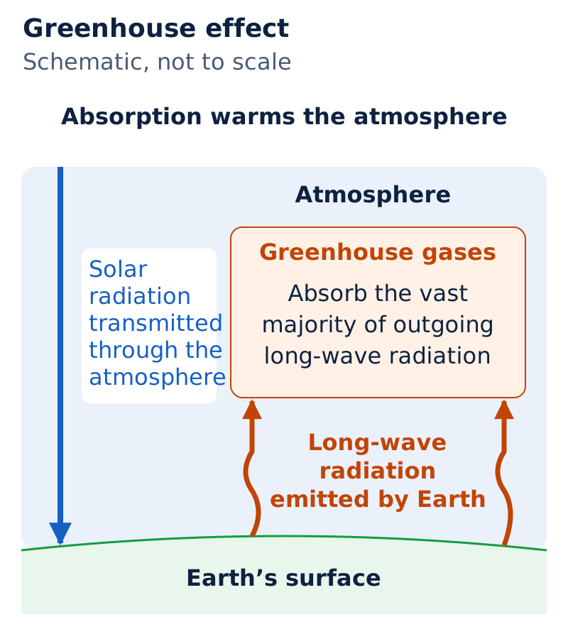
Draw Earth’s surface beneath an atmospheric layer. Label an incoming arrow “solar radiation transmitted through the atmosphere” and an upward arrow “long-wave radiation emitted by Earth”. Show greenhouse gases absorbing the vast majority of the outgoing long-wave radiation.
Drawn by One Young India.
The atmosphere transmits incoming solar radiation, while greenhouse gases absorb outgoing long-wave radiation emitted by Earth’s surface.
Which gases affect warming, and how do their effects differ?
The primary greenhouse gases of concern are carbon dioxide, written CO₂; chlorofluorocarbons, abbreviated CFCs; methane, CH₄; nitrous oxide, N₂O; and ozone, O₃. These formulas identify the named gases; the small numerals indicate numbers of atoms in a molecule.
Nitric oxide, NO, and carbon monoxide, CO, react easily with GHGs and affect their atmospheric concentrations. Concentration means the amount of a substance within a mixture. These two gases react with greenhouse gases and change their atmospheric concentrations.
What determines a greenhouse gas’s effectiveness?
Effectiveness depends on the magnitude of the increase in its concentration, its atmospheric lifetime and the wavelength it absorbs. Atmospheric lifetime means how long a molecule remains in the atmosphere. CFCs are highly effective.
The longer a greenhouse gas molecule remains, the longer Earth’s atmospheric system takes to recover from the change it produces. Persistence therefore matters alongside concentration and radiation absorption.
How do carbon dioxide sources and sinks operate?
Carbon dioxide emissions come mainly from fossil fuel combustion, meaning the burning of oil, gas and coal. Forests and oceans are carbon dioxide sinks, meaning they take up carbon dioxide. Forests use it in growth, so deforestation through land-use change also increases its concentration.
Atmospheric carbon dioxide takes 20 to 50 years to adjust to changes in sources and sinks. Its concentration rises at about 0.5 per cent annually. Doubling its pre-industrial concentration is an index used in climatic models, representations used to estimate climatic changes.
Pre-industrial refers to the period before industrialisation. An index here means a reference condition for estimating change. The doubling benchmark is a modelling reference, not a claim that the adjustment interval and the doubling time are identical.
Why must ozone depletion be distinguished from warming?
The stratosphere is the atmospheric layer above the troposphere, the lowest layer. Ozone absorbs ultraviolet radiation, radiation beyond violet in the spectrum, in the stratosphere. In the lower troposphere, ozone is very effective at absorbing terrestrial radiation, meaning radiation emitted by Earth.
CFCs are products of human activity. They drift into the stratosphere and destroy ozone. The ozone hole means depletion of stratospheric ozone concentration, with large depletion over Antarctica. It allows ultraviolet rays to pass through the troposphere.
What do warming records, possible effects and international action show?
The world’s annual average near-surface air temperature is approximately 14°C. Twentieth-century temperature records show an increasing trend, but warming was not evenly distributed through time. The periods of greatest warming were separated by a slight cooling.
| Period or comparison | Temperature finding |
|---|---|
| 1901 to 1944 | Global temperature rose by about 0.4°C |
| 1977 to 1999 | Global temperature rose by about 0.4°C |
| End of twentieth century compared with end of nineteenth century | Globally averaged annual mean temperature was about 0.6°C higher |
The intervening slight cooling was more marked in the Northern Hemisphere. Within the 1856 to 2000 record, the seven warmest years occurred in the last decade. The year 1998 was the warmest, probably not only for the twentieth century but also for the whole millennium.
What effects may follow increasing gas concentrations?
Increasing GHG concentrations may, in the long run, warm Earth. Once global warming sets in, it will be difficult to reverse. Its effects may not be uniform everywhere, but adverse effects will damage the life-supporting system.
Melting glaciers and ice caps, together with thermal expansion, the increase in seawater volume as it warms, can raise sea level. Rising seas may inundate, meaning flood, large parts of coastal areas and islands, leading to social problems.
What was the Kyoto Protocol commitment?
The Kyoto Protocol, an international agreement addressing GHG emissions, was proclaimed in 1997 and came into effect in 2005, ratified by 141 nations. Ratification means formal acceptance of an agreement.
It bound 35 industrialised countries to reduce emissions by 2012 to 5 per cent below 1990 levels. These dates distinguish proclamation, entry into effect, the target year and the reference year used for comparison.
International efforts seek to control GHG emissions and arrest the trend towards warming. Reducing emissions and adopting a lifestyle that leaves a liveable world for future generations are central concerns associated with this challenge.
Glossary
- Empirical classification — A classification based on observed data, particularly measurements of temperature and precipitation.
- Genetic classification — An approach that attempts to organise climates according to their causes.
- Applied classification — A classification of climates designed for a particular, specific purpose.
- Af climate — Tropical wet climate with significant rainfall in every month and no dry season.
- Am climate — Tropical monsoon climate with heavy rainfall mostly in summer and a dry winter.
- Aw climate — Tropical wet and dry climate with a shorter wet season and longer dry season.
- Permafrost — Permanently frozen subsoil associated with tundra regions and their limited plant growth.
- Sunspots — Dark and cooler patches on the sun that increase and decrease cyclically.
- Millankovitch oscillations — Cycles involving Earth’s orbital variations, wobbling and changes in axial tilt.
- Greenhouse gases — Atmospheric gases that absorb long-wave radiation emitted upwards by Earth’s surface.
- Greenhouse effect — The processes that warm the atmosphere, often collectively described using the greenhouse analogy.
- Carbon dioxide sinks — Forests and oceans that take up carbon dioxide from the atmosphere.
- Ozone hole — Depletion of ozone concentration in the stratosphere, allowing ultraviolet rays to pass through the troposphere.
Common errors and misconceptions
- Misconception: Koeppen’s scheme is genetic. Correct: It is empirical, using mean annual and monthly temperature and precipitation data.
- Misconception: All tropical climates lack a dry season. Correct: Af has no dry season, while Am and Aw have seasonal dryness.
- Misconception: Steppe rainfall is abundant and reliable. Correct: Subtropical steppe receives slightly more rain than desert, and rainfall in both is highly variable.
- Misconception: Mediterranean climate has summer rainfall and dry winters. Correct: Its summers are hot and dry; its winters are mild and rainy.
- Misconception: More sunspots are a proven cause of cooler, wetter weather. Correct: Some meteorologists propose the association, but the findings are not statistically significant.
- Misconception: The ozone hole is the definition of global warming. Correct: It is stratospheric ozone depletion; greenhouse warming involves absorption of outgoing long-wave radiation.
- Misconception: The 1998 ranking describes every later temperature record. Correct: The ranking applies to the 1856 to 2000 record; 1998 was probably also the warmest year of the millennium.
Exam-style questions with model answers
Q1. Empirical classification uses observed temperature and precipitation data; genetic classification groups climates by causes. State the basis of each classification. [2 marks]
- Empirical classification uses observed climatic measurements, particularly temperature and precipitation, as its basis for grouping climates.
- Genetic classification uses the causes responsible for climatic conditions as its organising basis.
Q2. Subtropical steppe receives slightly more rainfall than desert, supporting sparse grasslands. Rainfall in both is highly variable. State two conclusions about steppe moisture conditions. [2 marks]
- Steppe receives slightly more rainfall than desert, sufficient to support sparse grasslands.
- That rainfall remains highly variable, so the presence of grasslands does not mean that rainfall is reliable.
Q3. Af has significant rain every month and no dry season. Am has heavy rain mostly in summer and dry winters. Aw has considerably less, variable rainfall than Af and Am, with a shorter wet season and longer dry season. Compare these three tropical types using this information. [3 marks]
- Af is wet throughout the year, with significant rainfall in every month and no dry season to interrupt the annual rainfall pattern.
- Am has a seasonal concentration of heavy rainfall, occurring mostly during summer, while its winter season is dry.
- Aw receives considerably less rainfall than Af and Am. Its rainfall is variable, with a shorter wet season and longer dry season.
Q4. Mediterranean regions experience subtropical high pressure in summer and westerly winds in winter, producing hot, dry summers and mild, rainy winters. Monthly average temperatures are around 25°C in summer and below 10°C in winter; annual precipitation is 35 to 90 cm, meaning centimetres. Explain the seasonal pattern in three points. [3 marks]
- Summer subtropical high pressure is associated with hot, dry conditions. The monthly average temperature during summer is around 25°C.
- Winter westerly winds are associated with mild, rainy conditions. The monthly average winter temperature is below 10°C.
- Annual precipitation ranges from 35 to 90 cm. The seasonal contrast is therefore between summer dryness and winter rainfall.
Q5. Geological landforms preserve glacier advances and retreats; glacial lake sediments reveal warm and cold periods; tree rings indicate wet and dry periods; historical crop, flood and migration records show climatic effects. Explain four types of evidence for changing climate. [4 marks]
- Landforms preserve traces of glacier advances and retreats, providing evidence that glacial conditions have changed through time.
- Sediments deposited in glacial lakes reveal the occurrence of warm and cold periods, adding a separate natural record.
- Tree rings provide clues about wet and dry periods, helping identify variation in moisture conditions.
- Historical records of crops, floods and migration describe climatic variability and its effects on human activity.
Q6. Sunspot numbers rise and fall cyclically. Some meteorologists associate more sunspots, dark cooler patches on the sun, with cooler, wetter weather and greater storminess; fewer sunspots with warmer, drier conditions. The findings are not statistically significant. Explain the two proposed associations and the limitation. [3 marks]
- Increasing sunspot numbers are associated by some meteorologists with cooler and wetter weather, together with greater storminess. This is a proposed relationship.
- Decreasing sunspot numbers are associated with warmer and drier conditions, forming the other side of the proposed cyclical relationship.
- The findings are not statistically significant, so they must not be presented as an established rule predicting weather from sunspot numbers.
Q7. Greenhouse gases warm the atmosphere by absorbing outgoing long-wave radiation emitted upwards by Earth’s surface. Their effectiveness depends on concentration increase, atmospheric lifetime and absorbed wavelength. Longer persistence delays recovery. Fossil fuel burning emits carbon dioxide; forests and oceans absorb it, and deforestation increases its concentration. Explain the warming mechanism, the three factors governing greenhouse gas effectiveness, and the influence of carbon dioxide sources and sinks. [5 marks]
- Greenhouse gases absorb outgoing long-wave radiation emitted by Earth’s surface. This absorption is the defining property that connects the gases with atmospheric warming.
- The magnitude of the increase in a gas’s concentration affects its effectiveness. Concentration changes therefore matter when considering its warming influence.
- Atmospheric lifetime also matters. The longer a molecule remains in the atmosphere, the longer the atmospheric system takes to recover from its effects.
- The wavelength of radiation absorbed is another control on effectiveness. Absorption characteristics must therefore be considered alongside concentration change and atmospheric lifetime.
- Sources and sinks influence carbon dioxide concentration: fossil fuel burning adds it, forests and oceans absorb it, and deforestation increases its concentration.
Q8. Global temperature rose by about 0.4°C in each period, 1901 to 1944 and 1977 to 1999, with slight cooling between them, more marked in the Northern Hemisphere. The end-twentieth-century annual mean was about 0.6°C above the end-nineteenth-century value. In the 1856 to 2000 record, the last decade contained the seven warmest years; 1998 was warmest, probably also for the millennium. Describe the record in five points without strengthening its claims. [5 marks]
- The first major twentieth-century warming period ran from 1901 to 1944. Over this interval, global temperature increased by about 0.4°C.
- The second major warming period ran from 1977 to 1999. It also produced a global temperature increase of about 0.4°C.
- A slight cooling occurred between these warming periods and was more marked in the Northern Hemisphere. The record therefore contains interruptions to warming.
- The globally averaged annual mean at the end of the twentieth century was about 0.6°C above the corresponding end-nineteenth-century value.
- Within the 1856 to 2000 record, the last decade contained the seven warmest years. The warmest was 1998, probably also the warmest of the millennium.
Key takeaways
- Koeppen’s empirical classification uses temperature and precipitation, relating selected values to vegetation distribution and distinguishing five major climatic groups.
- Tropical climates share high temperatures but differ in rainfall seasonality: Af lacks a dry season, while Am and Aw have seasonal dryness.
- Dry climates occupy subtropical and continental interior settings; subtropical steppe receives slightly more rainfall than desert, supporting sparse grassland.
- Mediterranean summers are hot and dry, while marine west coast climates receive rain throughout the year and have small temperature ranges.
- Glacial landforms, lake sediments, tree rings and historical records reveal climatic changes across different periods and regions.
- Sunspot-weather associations are not statistically significant, while orbital variations might affect climate by changing incoming solar radiation.
- Greenhouse gases absorb outgoing long-wave radiation; their effectiveness depends on concentration increase, atmospheric lifetime and the wavelength absorbed.
- Warming effects may differ between places, and sea-level rise may inundate coastal areas and islands, creating social problems.
Test yourself
What distinguishes the basis of group B from the temperature-based groups?
Group B is defined by potential evaporation exceeding precipitation, rather than a temperature threshold.
What do f, m, w and s indicate in climatic codes?
The letters indicate no dry season, monsoon climate, winter dryness and summer dryness, respectively.
Why does marine west coast climate have moderate temperatures?
Marine influence moderates its temperature and makes winter warmer than expected for its latitude.
How does permafrost relate to tundra vegetation?
Tundra has permanently frozen subsoil. A short growing season and waterlogging support only low-growing plants.
What qualification belongs with the proposed sunspot-weather relationship?
The association is proposed by some meteorologists, but the findings are not statistically significant.
Which five primary greenhouse gases are listed?
They are carbon dioxide, chlorofluorocarbons, methane, nitrous oxide and ozone, all discussed as gases of concern.
What is meant by the ozone hole?
It means depletion of ozone concentration in the stratosphere, with large depletion occurring over Antarctica.
What emissions target did the Kyoto Protocol set for the 35 industrialised countries?
They were bound to reduce emissions by 2012 to 5 per cent below their 1990 levels.
Write about it
Turn a question from this chapter into a paper.
The Writing Studio has a structure guide, a rubric and citation tools for 15 formats, from essays to research papers. Drafting is free with an account. Learnacy Essential adds feedback from an AI writing coach and submission to The OYI Review.
Learnacy Essential is ₹1,499 for the year. Publication depends on review and is not guaranteed.