
Solar Radiation, Heat Balance and Temperature | CBSE Class 11 Geography Notes
On this page
This note covers incoming solar radiation, variations in insolation, atmospheric heating and cooling, terrestrial radiation, the earth’s heat budget, controls of temperature, January and July temperature patterns, temperature inversion, and the calculation of mean temperature and temperature range.
What is insolation, and how does the earth’s distance from the sun affect it?
The atmosphere is the envelope of gases surrounding the earth. The earth receives almost all of its energy from the sun and radiates energy back to space. Unequal heating creates differences in atmospheric pressure, the force exerted by air per unit area. These lead to heat transfer by winds, or moving air.
Heat represents molecular movement within a substance. Temperature measures in degrees how hot or cold a thing or place is. Radiation transfers energy, allowing the sun to supply energy to the earth and the earth to return energy to space.
Definition: Insolation means incoming solar radiation, the energy received by the earth from the sun. The earth’s surface receives most of its energy in short wavelengths.
Wavelength means the distance between successive corresponding points of a wave. Short-wave and long-wave radiation refer to radiation with shorter and longer wavelengths respectively. These terms help distinguish incoming solar energy from the energy later radiated by the heated earth.
The earth is a geoid, an earth-shaped body resembling a sphere. It intercepts a very small portion of the sun’s energy. On average, the top of its atmosphere receives 1.94 calories per square centimetre per minute. Calories measure energy; the area and time specify the rate of receipt.
How do aphelion and perihelion compare?
Revolution is the earth’s movement around the sun. During this movement, the earth-sun distance changes. Aphelion is the earth’s farthest position from the sun, while perihelion is its nearest position. The distances below are expressed in kilometres.
| Position | Date | Distance from the sun |
|---|---|---|
| Aphelion | 4 July | 152 million kilometres |
| Perihelion | 3 January | 147 million kilometres |
The solar energy received at the top of the atmosphere varies slightly over the year because of this changing distance. Insolation received on 3 January is slightly more than on 4 July.
However, the effects of land and sea distribution and atmospheric circulation, the movement of air through the atmosphere, mask this variation. It therefore does not have a great effect on daily weather changes at the earth’s surface.
Why does insolation vary with latitude, time and the angle of the sun’s rays?
The amount and intensity of insolation vary during a day, a season and a year. Intensity here concerns how concentrated the incoming energy is over an area. A place’s location and the conditions through which sunlight travels influence what reaches the surface.
Which factors control these variations?
- Rotation: the earth’s turning on its axis.
- Angle of inclination of the sun’s rays: the angle at which sunlight meets the earth’s surface.
- Length of the day: the duration of daylight.
- Transparency of the atmosphere: how readily radiation passes through the air.
- Aspect of the land: the direction a slope faces.
Latitude is angular distance north or south of the equator, the reference line dividing the earth into northern and southern halves. Higher latitude gives the sun’s rays a smaller angle with the surface, making them more slanting.
The last two factors have less influence. The earth’s axis makes an angle of 66½° with the plane of its orbit around the sun. The symbol ° means degrees of angle here. This inclination has a greater influence on insolation received at different latitudes.
How do slanting rays reduce energy per unit area?
- At higher latitudes, the sun’s rays meet the surface at a smaller angle.
- Slanting rays cover a larger area than vertical rays.
- The incoming energy is distributed across that larger area, reducing the energy received per unit area.
- The rays also pass through a greater depth of atmosphere, causing more absorption (taking in radiation), scattering (redirecting radiation) and diffusion (spreading radiation).
The summer solstice shown here is the June position with the sun overhead at 23.5° north at noon on 21 June. The Tropics of Cancer and Capricorn are the latitude lines at 23.5° north and south respectively.
What the figure shows
Summer solstice
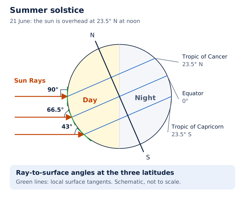
The drawing shows a tilted earth with day and night areas, horizontal arrows labelled Sun Rays, and the equator, Tropic of Cancer and Tropic of Capricorn. The labelled angles show that rays meet different parts of the surface differently.
Drawn by One Young India. See Fig. 8.1 in your NCERT textbook
What happens to solar radiation in the atmosphere and at the surface?
The atmosphere is largely transparent to short-wave solar radiation. Incoming radiation passes through it before reaching the ground. Transparency does not mean that all incoming energy reaches the surface unchanged: some radiation is absorbed, scattered or reflected, meaning sent back from a surface, along the way.
How do absorption and scattering differ?
Absorption is the taking in of radiation. Within the troposphere, the lowest atmospheric layer, water vapour (water in its gaseous form), ozone (a form of oxygen) and other gases absorb much of the near-infrared radiation. Near-infrared radiation lies just beyond the red end of visible light.
Scattering redirects light in different directions. Very small suspended particles in the troposphere scatter visible light both towards space and towards the earth’s surface. The red colour of the rising and setting sun and the blue sky result from this scattering.
Reflection sends radiation back from a surface. These processes explain why the energy arriving at the top of the atmosphere and the energy absorbed at the ground must be distinguished when studying the earth’s heat budget, the balance between incoming and outgoing energy.
Where is surface insolation greatest?
The tropics lie around the equator between the two tropic lines; the subtropics lie beyond them towards higher latitudes. The equator receives comparatively less insolation than the tropics. Subtropical deserts receive the maximum because cloudiness is least.
Surface insolation varies from about 320 watts per square metre in the tropics to about 70 watts per square metre at the poles. A watt measures the rate of energy transfer; “per square metre” specifies the receiving area.
| Region or comparison | Surface insolation | Feature to remember |
|---|---|---|
| Tropics | About 320 watts per square metre | Much greater than at the poles |
| Poles | About 70 watts per square metre | Much lower than in the tropics |
| Subtropical deserts | Maximum insolation | Cloudiness is least |
Generally, at the same latitude, continents receive more insolation than oceans. Middle and higher latitudes receive less radiation in winter than in summer. These comparisons connect spatial differences, meaning differences between places, with seasonal differences at a place.
How do conduction, convection, advection and terrestrial radiation heat the atmosphere?
The earth’s surface is heated by insolation and then transfers heat to the air. The atmosphere is thus heated through several processes. Their distinctions depend on whether heat moves through contact, vertical air movement, horizontal air movement or radiation from the earth.
How does contact transfer heat?
Conduction transfers heat between bodies of unequal temperature in contact. Energy flows from the warmer body to the cooler one. The transfer continues until their temperatures become equal or their contact is broken.
Air touching the heated land warms slowly. Upper layers touching the lower layers also become heated. Conduction is important in heating the lower layers of the atmosphere; its defining feature is contact between bodies or layers at different temperatures.
How does moving air transfer heat?
Convection is vertical heating of the atmosphere. Air in contact with the earth rises on heating in currents and transfers heat upwards. The convective transfer of energy is confined only to the troposphere.
Advection transfers heat through horizontal movement of air. Horizontal movement is relatively more important than vertical movement. In middle latitudes, most diurnal, meaning day-and-night, variations in daily weather are caused by advection alone.
In tropical regions, particularly northern India in summer, local winds called the loo are an outcome of advection. This example links a named local wind with horizontal heat transfer.
| Process | How heat is transferred | Distinguishing feature |
|---|---|---|
| Conduction | Contact between bodies of unequal temperature | Important near the ground |
| Convection | Rising currents of heated air | Vertical transfer within the troposphere |
| Advection | Horizontal movement of air | Transfers heat from one region to another |
What is terrestrial radiation?
Terrestrial radiation is the long-wave energy emitted by the heated earth. It heats the atmosphere from below. Atmospheric gases, particularly carbon dioxide and other greenhouse gases, absorb this long-wave radiation. Greenhouse gases are gases that absorb outgoing long-wave radiation.
A hotter body radiates more energy and radiation of shorter wavelength. The heated earth emits long-wave energy, while most incoming solar energy reaches its surface in short wavelengths.
The atmosphere then radiates and transmits heat to space. The receipt of short-wave solar energy, followed by the emission of long-wave terrestrial energy, connects the heating of the ground with the indirect heating of the atmosphere.
How does the earth’s heat budget balance incoming and outgoing energy?
The heat budget, or heat balance, compares energy received with energy returned to space. In the balanced earth-atmosphere system, the earth as a whole does not accumulate or lose heat. The account begins by treating incoming solar radiation as 100 units.
Here a unit means one part of the assumed total of 100, equivalent to one per cent. It is a share of the energy account, not a temperature. Roughly 35 units return to space without being absorbed by the earth-atmosphere system.
Where does the incoming energy go?
Albedo refers to reflected radiation; expressed as a percentage, it is the proportion reflected by an object. The energy returned towards space includes reflection from clouds and from snow and ice, as well as scattering.
| Destination or pathway | Units from the incoming 100 |
|---|---|
| Reflected by clouds | 27 |
| Reflected by the earth, including snow and ice | 2 |
| Scattered to space | 6 |
| Absorbed by the atmosphere | 14 |
| Absorbed by the earth’s surface | 51 |
The remaining 65 units are absorbed: 14 by the atmosphere and 51 by the surface. The surface then returns its 51 units through the pathways below. Turbulence means irregular air movement; latent heat of condensation is heat released when water vapour changes into liquid water.
| Surface energy pathway | Units |
|---|---|
| Radiated directly to space | 17 |
| Radiation absorbed directly by the atmosphere | 6 |
| Convection and turbulence | 9 |
| Latent heat of condensation | 19 |
How can the balance be checked?
In these calculations, the sign + means addition, and = means “equals”. Each sum follows the transfer of energy between the surface, atmosphere and space.
- Incoming energy is divided into roughly 35 units returned without absorption and 65 units absorbed.
- The absorbed total is 14 units in the atmosphere plus 51 units at the earth’s surface.
- The surface transfers 34 units to the atmosphere: 6 + 9 + 19 = 34.
- The atmosphere receives 14 + 34 = 48 units and radiates 48 units to space.
- Direct surface radiation and atmospheric radiation return 17 + 48 = 65 units, balancing the absorbed solar energy.
What the figure shows
Heat budget of the earth
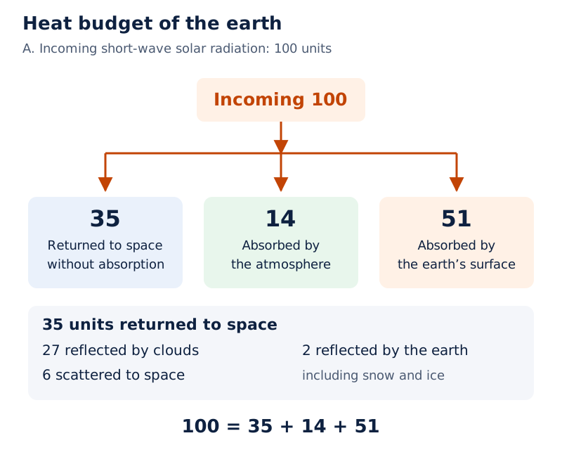
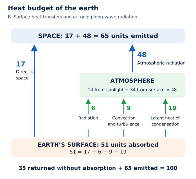
Two panels separate short-wave solar radiation from long-wave earth radiation. Arrows show incoming 100 units, cloud reflection of 27, earth reflection of 2, scattering of 6, and outgoing radiation of 17 from the earth and 48 from the atmosphere.
Drawn by One Young India. See Fig. 8.2 in your NCERT textbook
Adding the roughly 35 units returned without absorption to the 65 emitted units accounts for the incoming 100. Heat balance therefore involves the whole system and several energy pathways, rather than a single direct exchange between the ground and space.
Why does global heat balance coexist with regional heat surpluses and deficits?
A balance for the earth as a whole does not mean that every region receives and loses equal amounts of radiation. Net radiation balance is the difference between radiation received and radiation lost. Different regions have different balances.
A surplus means that received radiation exceeds radiation lost. A deficit means that radiation lost exceeds radiation received. These terms describe an energy comparison, rather than the temperature measured at a single place.
Where are the surplus and deficit regions?
There is a surplus of net radiation between 40° north and 40° south, while regions near the poles have a deficit. The surplus heat of the tropics is redistributed polewards, meaning towards the poles.
This transfer prevents the tropics from becoming progressively hotter through accumulating excess heat, and prevents high latitudes from becoming permanently frozen through excess deficit. Regional gains and losses are therefore connected by redistribution of heat.
What the figure shows
Latitudinal variation in net radiation balance
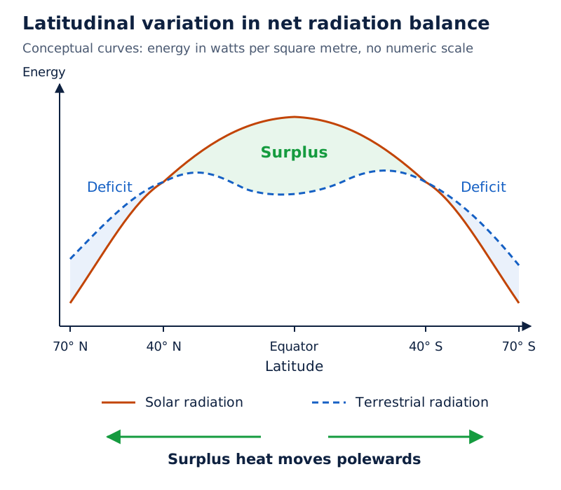
Latitude runs across the horizontal axis from north through the equator to south. The vertical axis shows energy in watts per square metre. A solid solar-radiation curve and a broken terrestrial-radiation curve enclose a central surplus area and deficit areas towards both ends.
Drawn by One Young India. See Fig. 8.3 in your NCERT textbook
How does unequal heating affect the air?
Unequal heat receipt causes pressure differences in the atmosphere. Winds transfer heat between regions. This connects the regional energy account with atmospheric movement: the distribution of heat helps explain why the atmosphere moves and why temperature differs from place to place.
Keep the two scales distinct. The global heat budget compares the total incoming and outgoing energy of the earth-atmosphere system. The latitudinal comparison shows where surpluses and deficits occur within that system, and why redistribution is necessary.
What controls the temperature of a place?
Heat represents molecular movement within a substance. Temperature measures in degrees how hot or cold a thing or place is. Insolation interacting with the atmosphere and the surface creates heat, but local temperature depends on several controls working together.
How do latitude and altitude matter?
Latitude influences insolation and therefore temperature. Altitude means height above sea level. As the atmosphere is indirectly heated from below by terrestrial radiation, places near sea level record higher temperatures than places at higher elevations.
Temperature generally decreases with increasing height. The normal lapse rate is the rate of this decrease: 6.5°C per 1,000 metres. The symbol °C means degrees Celsius, the temperature unit used here. “Generally” matters because the usual pattern can be reversed.
How do the sea, air masses and ocean currents matter?
Compared with land, the sea heats slowly and loses heat slowly. Land heats and cools quickly. Temperature variation over the sea is therefore less than over land. Coastal places experience the moderating influence of sea and land breezes, winds between the sea and land.
An air mass is a large body of air with broadly similar temperature and moisture characteristics. Places influenced by warm air masses experience higher temperatures; those influenced by cold air masses experience lower temperatures.
Ocean currents are moving streams of ocean water. Coasts beside warm currents record higher temperatures than coasts beside cold currents. Local aspects, including the direction faced by the land, also influence temperature.
| Control | Connection with temperature |
|---|---|
| Latitude | Changes the insolation received |
| Altitude | Temperature generally falls with increasing height |
| Distance from the sea | Changes exposure to the sea’s moderating influence |
| Air-mass circulation | Brings the influence of warmer or colder air |
| Warm and cold ocean currents | Affect temperatures along coasts |
| Local aspects | Include the orientation of the land |
Specific heat is the energy needed to raise the temperature of one gram of a substance by one degree Celsius. It is an energy requirement for heating a substance, whereas temperature describes how hot or cold that substance is.
How do isotherms show January temperature patterns?
Isotherms are lines joining places with equal temperature. Maps of January and July temperatures reveal broad global patterns. Isotherms are generally parallel to latitude lines, showing the influence of latitude, but land and sea distribution and ocean currents cause deviations.
A hemisphere is half of the earth. The northern hemisphere has a much larger land surface area than the southern hemisphere. The effects of land masses and ocean currents are therefore well pronounced in northern temperature patterns.
Case study: Why do North Atlantic isotherms bend in January?
In January, northern hemisphere isotherms bend northwards over oceans and southwards over continents. The Gulf Stream and North Atlantic Drift are warm ocean currents. They make the North Atlantic Ocean warmer and cause isotherms there to bend northwards.
Over European land, temperature decreases sharply and isotherms bend southwards. This is especially pronounced in the Siberian plain. Deviations from the general latitude-parallel pattern are more pronounced in January than July, especially in the northern hemisphere.
Longitude is angular position east or west of the reference meridian. In location labels, E means east, N north and S south. Along 60° E longitude, mean January temperature is minus 20°C at both 80° N and 50° N.
What the figure shows
January surface air temperature
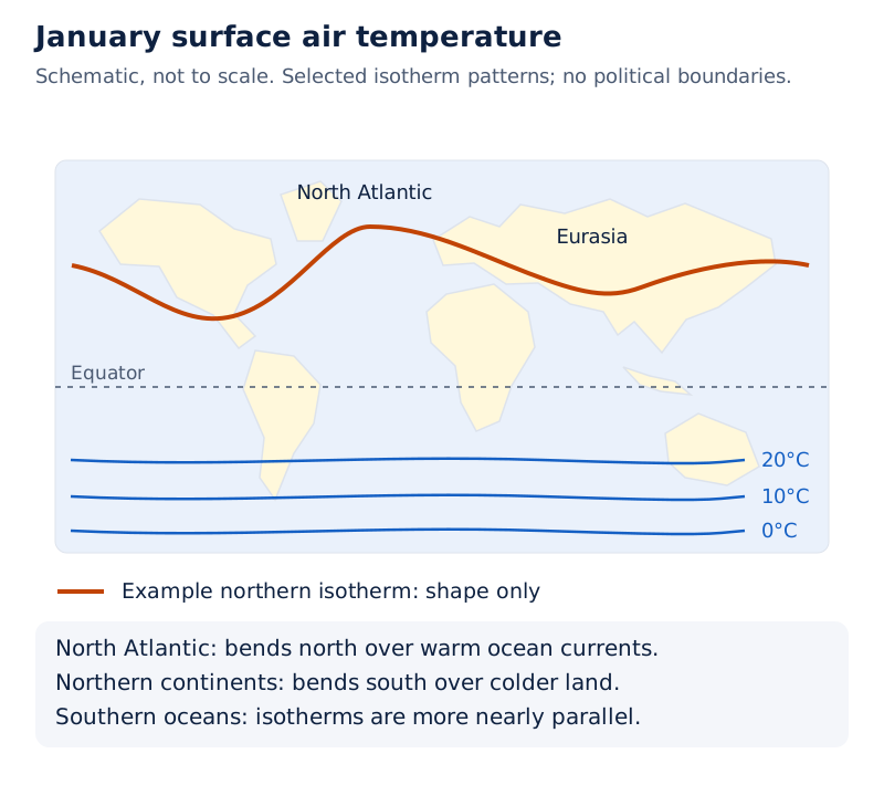
The world map shows curved isotherms with temperature labels. The lines bend strongly over northern continents and oceans, while southern ocean lines run more nearly across the map. The equator provides a reference for comparing the two hemispheres.
Drawn by One Young India. See Fig. 8.4(a) in your NCERT textbook
How does the southern hemisphere differ?
The ocean’s effect is well pronounced in the southern hemisphere. Isotherms are more or less parallel to latitudes, and temperature varies more gradually than in the northern hemisphere. The 20°C, 10°C and 0°C isotherms run parallel to 35° S, 45° S and 60° S respectively.
Mean January temperature is over 27°C in equatorial oceans and over 24°C in the tropics. In the Eurasian continental interior, the January mean monthly temperatures range from minus 18°C to minus 48°C, showing the strong winter contrast with equatorial ocean areas.
How do July temperatures and temperature ranges vary across the world?
In July, isotherms generally run parallel to latitude lines. Equatorial oceans record temperatures of more than 27°C. Over land, temperatures above 30°C occur in the subtropical continental region of Asia along 30° N latitude.
What the figure shows
July surface air temperature
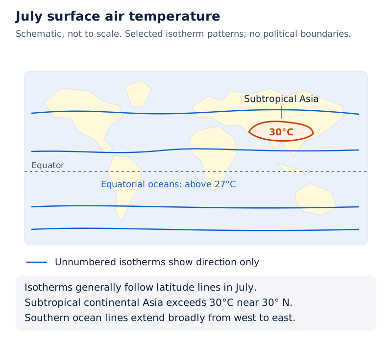
The world map labels isotherms across continents and oceans. The 30°C contours mark warm areas across parts of northern land, including Asia. Across the southern oceans, temperature lines extend broadly from west to east.
Drawn by One Young India. See Fig. 8.4(b) in your NCERT textbook
What is annual temperature range?
Annual range of temperature means the difference between the mean temperature of the warmest month and that of the coldest month. A mean is an average. The range measures the contrast between the months, not the temperature of either month alone.
Continentality means the influence of a continental location, associated with greater temperature variation than under the moderating influence of the sea. It helps explain the very large January-to-July temperature range in north-eastern Eurasia.
| Region | Temperature feature |
|---|---|
| Equatorial oceans in July | More than 27°C |
| Subtropical continental Asia along 30° N in July | More than 30°C |
| North-eastern Eurasia | January-to-July range of more than 60°C |
| Belt between 20° S and 15° N | Least January-to-July range, 3°C |
What the figure shows
Temperature range between January and July
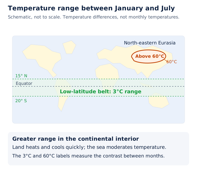
The map shows temperature-range contours. Closely enclosed high-range contours, including 60°C, appear over north-eastern Eurasia, while 3°C labels occur in the low-latitude belt. These labels show differences between months, rather than monthly temperatures.
Drawn by One Young India. See Fig. 8.5 in your NCERT textbook
A large range and a high temperature describe different features. The first compares temperatures at different times. The second gives a temperature level. Keeping this distinction clear is essential when comparing the July map with the January-to-July range map.
What causes temperature inversion, and what effects does it have?
Temperature inversion reverses the usual decrease of temperature with elevation: colder air lies below warmer air. Inversion is usually of short duration, but it is quite common. Over polar areas, temperature inversion is normal throughout the year.
How does surface inversion develop?
- A long winter night with clear skies and still air provides an ideal situation for inversion.
- The earth radiates away the heat received during the day.
- By early morning, the earth is cooler than the air above it.
- The usual temperature arrangement is reversed, with colder conditions below warmer air.
Surface inversion, inversion close to the ground, promotes stability in the lower atmosphere. Here stability means resistance to vertical mixing. Smoke and dust collect beneath the inversion layer and spread horizontally through the lower layers.
Dense morning fogs are common, especially during winter. A fog is a cloud of tiny water droplets close to the ground. This surface inversion commonly lasts for a few hours, until the sun rises and begins warming the earth.
How does air drainage produce inversion in hills?
Air drainage is the downslope flow and collection of cold air under gravity. At night, cold air forms over hills and mountains. Being heavy and dense, it behaves almost like water as it moves down the slopes.
The cold air piles up deeply in pockets and valley bottoms, leaving warmer air above it. This creates an inversion in which the ordinary decrease of temperature with height is reversed. The important sequence is night-time cooling, downslope movement and collection of cold air below warm air.
Note: “Usually of short duration” and “commonly lasts for a few hours” describe typical inversion behaviour. They do not remove the separate point that inversion is normal throughout the year over polar areas.
How are monthly mean temperatures and temperature ranges calculated?
A mean daily maximum is an average of daily highest temperatures, while a mean daily minimum is an average of daily lowest temperatures. Taking the average of these two values gives the daily mean monthly temperature used in the calculation below.
Case study: What do the New Delhi observations show?
The New Delhi (Safdarjung) observatory example uses observations from 1951 to 1980. Its altitude is 216 metres above mean sea level, the average sea-level reference used for elevations. January and May values allow the monthly means to be calculated.
| Month | Mean daily maximum | Mean daily minimum | Highest recorded | Lowest recorded |
|---|---|---|---|---|
| January | 21.1°C | 7.3°C | 29.3°C | 0.6°C |
| May | 39.6°C | 25.9°C | 47.2°C | 17.5°C |
The sign ÷ means division. Brackets group values to be added before division. Daily mean monthly temperature = (mean daily maximum + mean daily minimum) ÷ 2. Every temperature here is expressed in degrees Celsius.
For January, the calculation is (21.1 + 7.3) ÷ 2 = 14.2°C. For May, it is (39.6 + 25.9) ÷ 2 = 32.75°C.
Using May as the warmest month and January as the coldest month in this example, the annual range is 32.75°C minus 14.2°C = 18.55°C. The subtraction uses the two monthly mean temperatures.
Which values should remain separate?
The highest recorded temperature is an extreme value, whereas the mean daily maximum averages daily maxima. Similarly, the lowest recorded value is different from the mean daily minimum. These columns describe different features of the temperature record.
For the annual range calculation, subtract the mean temperature of the coldest month from that of the warmest month. Do not replace either monthly mean with a single highest or lowest recorded temperature: that would answer a different question.
Glossary
- Insolation — Incoming solar radiation, meaning the energy received by the earth from the sun.
- Aphelion — The earth’s farthest position from the sun during its revolution, reached on 4 July.
- Perihelion — The earth’s nearest position to the sun during its revolution, reached on 3 January.
- Conduction — Transfer of heat from a warmer body to a cooler body through contact.
- Convection — Vertical heating of the atmosphere through rising currents of air heated near the earth’s surface.
- Advection — Transfer of heat through the horizontal movement of air from one region to another.
- Terrestrial radiation — Long-wave energy radiated by the heated earth, which heats the atmosphere from below.
- Albedo — Reflected radiation, expressed as the proportion or percentage of incoming radiation reflected by an object.
- Heat budget — The balance between energy received and energy returned to space by the earth-atmosphere system.
- Normal lapse rate — The rate of temperature decrease with height, given as 6.5°C per 1,000 metres.
- Isotherms — Lines drawn on a map to join places having equal temperatures.
- Annual temperature range — The difference between the mean temperatures of the warmest and coldest months.
- Temperature inversion — Reversal of the usual temperature decrease with elevation, leaving colder air below warmer air.
- Air drainage — Downslope movement of cold, dense air under gravity into pockets and valley bottoms.
- Specific heat — Energy needed to raise the temperature of one gram of a substance by one degree Celsius.
Common errors and misconceptions
- Misconception: The earth-sun distance is the main explanation of daily weather changes. Correct: Its effect is masked by other factors and does not have a great effect on daily weather.
- Misconception: The equator receives the maximum surface insolation. Correct: Subtropical deserts receive the maximum because cloudiness is least; the equator receives comparatively less than the tropics.
- Misconception: Convection and advection both mean upward heat transfer. Correct: Convection involves vertical movement; advection transfers heat through horizontal air movement.
- Misconception: The atmosphere is heated mainly by direct short-wave sunlight. Correct: It is indirectly heated from below by long-wave terrestrial radiation.
- Misconception: Global heat balance means every latitude has zero net radiation. Correct: Low latitudes have a surplus and regions near the poles a deficit; heat is redistributed polewards.
- Misconception: Temperature must decrease with height in every situation. Correct: It generally decreases, but inversion reverses the usual arrangement.
- Misconception: Annual temperature range uses the highest and lowest individual readings. Correct: It uses the mean temperatures of the warmest and coldest months.
Exam-style questions with model answers
Q1. Define insolation and distinguish it from terrestrial radiation by their direction of transfer and wavelength. [2 marks]
- Insolation is incoming solar radiation received by the earth; the surface receives most of this energy in short wavelengths.
- Terrestrial radiation is long-wave energy emitted by the heated earth, which heats the atmosphere from below.
Q2. Explain how conduction, convection and advection transfer heat in the atmosphere. Give one separate point for each process. [3 marks]
- Conduction transfers heat through contact between bodies of unequal temperature. Energy passes from the warmer body to the cooler body until temperatures become equal or contact breaks.
- Convection transfers heat vertically as air warmed near the earth’s surface rises in currents. This convective transfer is confined to the troposphere.
- Advection transfers heat through horizontal air movement. It moves heat between regions and is relatively more important than vertical movement.
Q3. Explain why slanting sun rays deliver less energy per unit area than vertical rays. Include latitude, area covered and passage through the atmosphere. [4 marks]
- At higher latitudes, the sun’s rays make a smaller angle with the earth’s surface and therefore arrive more obliquely.
- Slanting rays cover a larger surface area than vertical rays, so the incoming energy is spread more widely.
- Because this energy is distributed over a larger area, the energy received per unit area decreases.
- Slanting rays also travel through a greater depth of atmosphere, producing more absorption, scattering and diffusion before they reach the surface.
Q4. In a heat budget of 100 incoming units, roughly 35 return without absorption, 14 are absorbed by the atmosphere and 51 by the surface. The surface sends 17 directly to space, 6 to the atmosphere by radiation, 9 by convection and turbulence, and 19 through latent heat of condensation. Show in five steps how the absorbed energy balances if the atmosphere emits all the energy it receives. [5 marks]
- The absorbed solar energy is 100 minus roughly 35, or 65 units. This is the energy retained for transfer through the earth-atmosphere system.
- The initial absorption is divided between 14 units in the atmosphere and 51 at the surface. Their sum is 65 units.
- The surface transfers 6 + 9 + 19 = 34 units to the atmosphere. Together with its 17 units sent directly to space, this accounts for 51 units.
- The atmosphere receives 14 + 34 = 48 units in total. Under the stated balance, it radiates these 48 units back to space.
- The outgoing radiation is therefore 17 + 48 = 65 units, equal to absorbed solar energy. Including the roughly 35 unabsorbed units completes the 100-unit account.
Q5. In January, the Gulf Stream and North Atlantic Drift warm the North Atlantic, while European land cools sharply. The northern hemisphere has more land than the southern hemisphere. Explain the resulting isotherm patterns and the ocean’s moderating influence in five points. [5 marks]
- Isotherms join places with equal temperature. They are generally parallel to latitude lines, but land masses and ocean currents can cause substantial deviations.
- The warm Gulf Stream and North Atlantic Drift make the North Atlantic warmer. Isotherms consequently bend northwards over this ocean in January.
- Over Europe, the sharp decrease of temperature over land bends isotherms southwards. This contrasts with their northward bending over the warm ocean.
- The larger northern land area makes the effects of land masses and ocean currents well pronounced. Land heats and cools more quickly than the sea.
- The ocean’s influence is well pronounced in the southern hemisphere. Its isotherms are more or less parallel to latitudes, and temperature varies more gradually than in the north.
Q6. A long winter night has clear skies and still air. Explain how surface temperature inversion develops and describe its effect on smoke and dust. [3 marks]
- During the long, clear winter night, the earth radiates away the heat received during the day. By early morning, the ground is cooler than the air above.
- This reverses the normal temperature arrangement, producing temperature inversion. Colder air lies below warmer air instead of temperature decreasing with increasing elevation.
- Surface inversion promotes stability in the lower atmosphere. Smoke and dust collect beneath the inversion layer and spread horizontally through the lower layers.
Q7. For New Delhi, January’s mean daily maximum and minimum are 21.1°C and 7.3°C; May’s are 39.6°C and 25.9°C. Calculate each monthly mean by averaging its maximum and minimum means. Treat May as the warmest month and January as the coldest. Calculate the annual range and state why these monthly means are used. [4 marks]
- January’s daily mean monthly temperature is (21.1 + 7.3) ÷ 2 = 14.2°C, using the given mean daily maximum and minimum.
- May’s daily mean monthly temperature is (39.6 + 25.9) ÷ 2 = 32.75°C, calculated by the same averaging method.
- The annual temperature range is the warmest monthly mean minus the coldest monthly mean: 32.75°C minus 14.2°C = 18.55°C.
- Monthly means are used because annual range compares the mean temperatures of the warmest and coldest months, rather than individual extreme readings.
Q8. The January-to-July temperature range exceeds 60°C in north-eastern Eurasia and is 3°C between 20° S and 15° N. Identify the region with the greater range and explain its high range using continentality. [2 marks]
- North-eastern Eurasia has the greater range, exceeding 60°C compared with 3°C in the stated low-latitude belt.
- Continentality explains its high range: land heats and cools quickly, whereas the sea has a moderating influence on temperature.
Key takeaways
- Insolation is incoming solar radiation; the earth’s surface receives most of its solar energy in short wavelengths.
- Slanting rays spread energy across a larger area and pass through a greater depth of atmosphere.
- Conduction transfers heat by contact, convection through vertical air movement, and advection through horizontal air movement.
- The atmosphere is indirectly heated from below by long-wave radiation emitted by the heated earth.
- In the 100-unit heat budget, 65 units are absorbed and balanced by 17 plus 48 units radiated to space.
- Latitude, altitude, distance from the sea, air masses, ocean currents and local aspects influence temperature distribution.
- January isotherms bend northwards over the North Atlantic and southwards over cold northern continental areas.
- Temperature inversion reverses the usual decrease with height, while annual range compares the warmest and coldest monthly means.
Test yourself
What do aphelion and perihelion mean?
Aphelion is the earth’s farthest position from the sun; perihelion is its nearest position.
Why do subtropical deserts receive maximum surface insolation?
They receive maximum insolation because cloudiness is least over these regions.
Which direction of air movement distinguishes convection from advection?
Convection involves vertical air movement, while advection transfers heat through horizontal air movement.
What is the normal lapse rate?
It is the rate of temperature decrease with height, given as 6.5°C per 1,000 metres.
Why are coastal temperatures moderated by the sea?
The sea heats and cools slowly compared with land; sea and land breezes moderate temperatures near the coast.
What conditions are ideal for surface temperature inversion?
A long winter night with clear skies and still air is ideal for surface inversion.
How does air drainage arrange cold and warm air in a valley?
Cold, dense air moves downslope and collects in valley bottoms, leaving warmer air above it.
Why does a global heat balance still require poleward heat transfer?
Low latitudes have a radiation surplus while regions near the poles have a deficit, so surplus heat is redistributed polewards.
Write about it
Turn a question from this chapter into a paper.
The Writing Studio has a structure guide, a rubric and citation tools for 15 formats, from essays to research papers. Drafting is free with an account. Learnacy Essential adds feedback from an AI writing coach and submission to The OYI Review.
Publication depends on review and is not guaranteed.