
Atmosphere and Climate | CBSE Class 9 Geography Notes
On this page

This note covers the atmosphere’s composition and layers, weather and climate, temperature, moisture, pressure, winds, India’s seasons, monsoons, climate change, carbon footprints, the Punjab floods of 2025, and monthly temperature and rainfall data.
What is the atmosphere, and what does it contain?
The atmosphere is the blanket of air surrounding the Earth. Gravity, the force of attraction between objects with mass or energy, holds it around the planet. Earth’s gravity is the attraction exerted by Earth’s mass on objects on or near its surface.
The atmosphere contains a mixture of gases essential for life. It shields the Earth from harmful solar radiation, including ultraviolet radiation, a form of solar radiation, and regulates temperature by trapping some of the Sun’s energy instead of allowing it to escape into space.
Which gases are most abundant?
Nitrogen and oxygen are the two most abundant gases. Smaller quantities of carbon dioxide, argon, helium, neon, krypton, xenon, ozone and hydrogen are also present. The symbol % means per cent, or out of one hundred.
| Component | Percentage |
|---|---|
| Nitrogen | 78% |
| Oxygen | 21% |
| Argon | 0.93% |
| Carbon dioxide | 0.04% |
| Others | 0.03% |
What the figure shows
Composition of the atmosphere
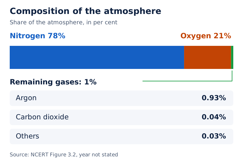
A circular graphic surrounds a drawing of the Earth. Nitrogen occupies the largest part, oxygen the next largest, and small labelled portions represent argon, carbon dioxide and other gases.
Drawn by One Young India. See Fig. 3.2 in your NCERT textbook
The air also contains water vapour, water in its gaseous form, and tiny dust particles. The amount of water vapour varies, but generally ranges from 0.1 per cent to 0.4 per cent. It has a significant role in cloud formation and precipitation, or water falling from the atmosphere.
Composition also varies with altitude, the height of a place above mean sea level. Mean sea level is taken as zero. Air density, meaning how much air is packed into a given space, is highest near Earth’s surface and decreases with altitude.
How do the five atmospheric layers differ?
The atmosphere’s layers are distinguished by changes in temperature and air density with increasing altitude. From Earth’s surface upwards, they are the troposphere, stratosphere, mesosphere, thermosphere and exosphere. Heights below use km, the abbreviation for kilometres.
What happens in the lower layers?
The troposphere has an average height of about 12 kilometres. Temperature decreases as altitude increases. It contains the air we breathe, most water vapour and clouds. Nearly all weather phenomena, including rainfall, fog and hail, occur here.
The tropopause is the transition zone separating the troposphere from the stratosphere. The stratosphere extends up to 50 kilometres. It is ideal for flying aeroplanes because it is free of clouds and other weather disturbances.
The stratosphere contains the ozone layer, a layer of ozone gas that filters harmful solar radiation, including ultraviolet radiation. The stratopause marks the boundary between the stratosphere and the mesosphere.
What happens higher up?
| Layer | Extent or position | Main features |
|---|---|---|
| Mesosphere | Up to 80 km | Temperature decreases with altitude; most meteorites, objects entering from space, burn up here. |
| Thermosphere | 80 to 700 km | Temperature rises very rapidly with altitude; radio transmission and auroras, colourful light displays near the poles, are associated with this layer. |
| Exosphere | Uppermost layer | Air is very thin; light gases such as helium and hydrogen float into space due to weak gravity. |
Thermospheric gas molecules absorb the Sun’s X-rays and short-wave ultraviolet radiation, causing rapid heating. The ionosphere is part of the thermosphere. Reflection of radio waves transmitted from Earth back towards it helps radio transmission.
Auroras are colourful displays of light near the poles. The solar wind consists of charged particles emitted by the Sun. These particles are directed towards Earth’s magnetic poles, where interaction with atmospheric gases makes different gases glow in particular colours.
The northern display is the Aurora Borealis, while the southern display is the Aurora Australis. These occur in the thermosphere. Temperature decreases with altitude only in the troposphere and mesosphere.
What the figure shows
Layers of the atmosphere
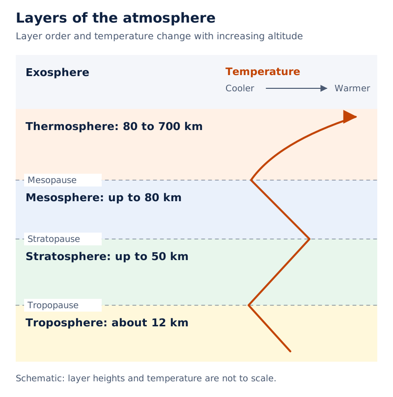
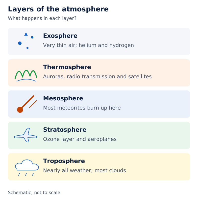
The vertical diagram labels all five layers and the tropopause, stratopause and mesopause boundaries. The mesopause is the boundary above the mesosphere. A white line shows temperature variation with height. An aeroplane, meteors, a satellite and an aurora are drawn beside the layers.
Drawn by One Young India. See Fig. 3.3 in your NCERT textbook
How are weather, climate and temperature related?
Definition: Weather means the hour-to-hour and day-to-day conditions of the atmosphere. Climate refers to the sum total of weather conditions and variations over a large area for an extended period, usually thirty years or more.
Weather can vary significantly from one day to the next, sometimes even within a day. Hot or humid conditions may make a person irritable, while pleasant or breezy conditions may make a person cheerful or encourage an outing.
Climate describes the longer-term pattern. Its meaning includes average conditions as well as variations. A particular rainy day describes weather; understanding the conditions of a place over a much longer period concerns climate.
What controls the distribution of temperature?
Temperature, the degree of hotness or coldness, varies between day and night and across seasons. Summers tend to be hotter than winters. An important influence is insolation, incoming solar energy intercepted by the Earth.
The equator is the imaginary line midway between Earth’s poles. The poles are the northern and southern ends of its axis of rotation. The amount of insolation decreases from the equator towards the poles. Temperature therefore decreases in the same direction. The major elements used to describe weather and climate are temperature, precipitation, humidity, wind and atmospheric pressure. Each can change under varying conditions.
What the figure shows
Temperature zones of the Earth
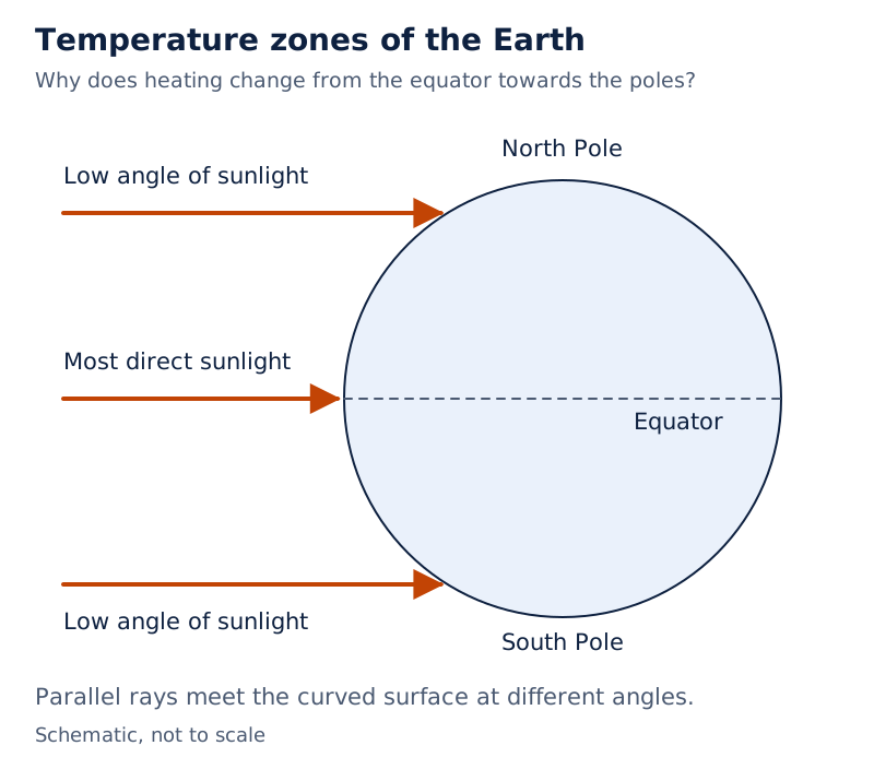
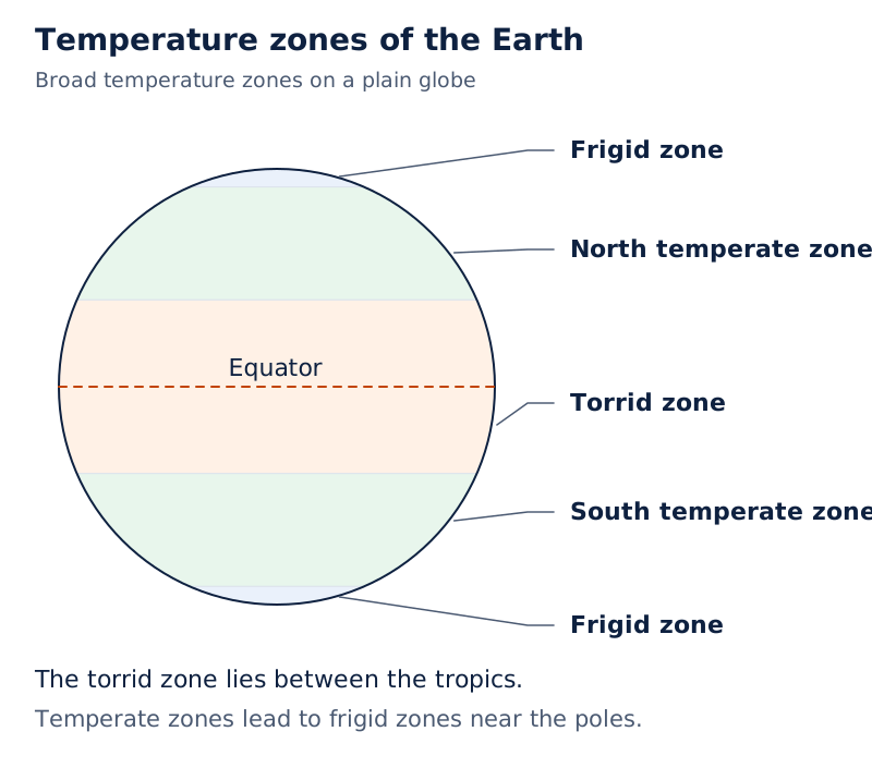
One globe shows sunlight striking most directly near the equator and at a low angle towards the poles. Another labels the torrid zone around the equator, temperate zones beyond the tropics and frigid zones near the poles.
Drawn by One Young India. See Fig. 3.6 in your NCERT textbook
The torrid, temperate and frigid zones are the temperature zones shown in this diagram. Their arrangement connects the changing angle of sunlight with the broad pattern of temperature from the equator towards the poles.
How do humidity and precipitation affect daily life?
Humidity means the presence of water vapour in the air, creating moisture. Evaporation, the change of water into vapour, takes place from land and water bodies. High levels of water vapour produce humid conditions.
As air becomes warmer, its capacity to hold water vapour increases, leading to higher humidity levels. On a humid day, clothes take longer to dry and sweat evaporates more slowly. This slow evaporation makes people feel uncomfortable.
How does water return to the Earth?
Precipitation occurs when part of the atmosphere becomes saturated with water vapour, meaning it has reached its capacity to hold vapour. The vapour condenses, changing into water droplets, and precipitation falls to Earth under gravity.
The forms of precipitation include drizzle, rain, snow, sleet and hail. Rain is precipitation in liquid form and is the most common form. Prevailing winds, mountains and seasons are the main factors affecting precipitation.
Rain lowers the temperature of a place. A long absence of rainfall produces a dry climate. Most groundwater, meaning water below the ground, is collected from rainwater. Rainfall therefore matters both for conditions at the surface and for water available underground.
Note: Humidity and precipitation describe different things. Humidity concerns water vapour present in air; precipitation concerns water falling from the atmosphere. Rain is one form of precipitation, while snow, sleet and hail are other forms.
How do pressure differences produce winds?
Atmospheric pressure, also called air pressure, is the pressure exerted by the weight of air on Earth’s surface. It is highest at sea level and falls rapidly as altitude increases. Temperature influences its horizontal distribution.
Why do high- and low-pressure areas develop?
- In a hot area, air heats up and rises, producing a low-pressure area, an area with relatively lower air pressure.
- In a cooler area, cold air is heavy and sinks, producing a high-pressure area, an area with relatively higher air pressure.
- Air moves from a high-pressure area towards a low-pressure area.
- This movement of air is called wind. Its direction is influenced by Earth’s rotation.
Low pressure is associated with cloudy skies and wet weather. High pressure is associated with clear and sunny skies. Winds are named after the direction from which they blow: a westerly blows from the west.
Wind may gently move dust and dry leaves or become strong enough to uproot trees in a storm. Wind speed below is expressed in km/hr, meaning kilometres per hour. A vane is an instrument that indicates wind direction.
| Wind | Speed (km/hr) | Common effects |
|---|---|---|
| Calm | 0 to 1 | Calm, smoke rises vertically. |
| Light breeze | 6 to 11 | Wind can be felt on the face. Leaves rustle. An ordinary vane moves by winds. |
| Strong breeze | 39 to 49 | Large branches sway in the wind. Umbrellas are difficult to use. |
| Storm | 103 to 117 | It is very rarely experienced. Usually accompanied by widespread damage. |
Although the air above us exerts considerable force, we do not feel it because it presses from all sides and our bodies exert a counter-pressure in response.
What the figure shows
Pressure acting on the body
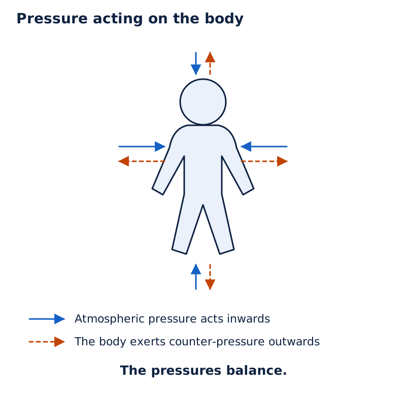
Arrows point towards and away from a human figure. The pressure inside the body equals atmospheric pressure and cancels the pressure from outside.
Drawn by One Young India. See Fig. 3.5 in your NCERT textbook
Why do sea breezes and land breezes reverse direction?
Local winds, such as sea breezes and land breezes, affect the weather and climate of a place. They are essential in creating moderate climatic conditions in coastal regions. Their direction changes because land and sea heat and cool differently.
What happens during the day?
A sea breeze blows from sea to land during the day, especially in the afternoon. The land becomes relatively warmer than the sea, producing a low-pressure region over the land. Air then moves from the sea towards it.
What happens during the night?
A land breeze blows from land to sea at night. Land cools faster than the sea, so their relative temperatures change. Differences in temperature and pressure are low, and the wind speed is therefore low.
| Feature | Sea breeze | Land breeze |
|---|---|---|
| Time | Day, especially afternoon | Night |
| Relatively warmer surface | Land | Sea |
| Direction | Sea to land | Land to sea |
What the figure shows
Land and sea breeze
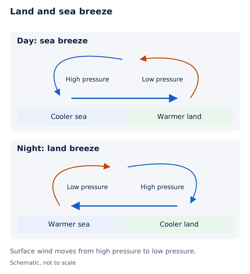
Two coastal sketches show daytime and night-time air circulation. Near the surface, the daytime arrow points from water towards land; the night-time arrow points from land towards water. Curved arrows complete each circulation loop.
Drawn by One Young India. See Fig. 3.8 in your NCERT textbook
Which seasons does India experience?
Seasons are divisions of the year based on generalised monthly atmospheric conditions or common patterns lasting weeks or months. These patterns include hot or cool, windy or calm, cloudy or bright, and wet or dry conditions.
India’s climate can be broadly classified as tropical monsoon, with a strong influence from seasonal winds. A monsoon is a seasonal reversal in wind direction during a year. The Indian Meteorological Department, abbreviated as IMD, recognises four distinct seasons.
What are the four main seasons?
Temperatures below use °C, meaning degrees Celsius, a unit of temperature.
| Season | Duration | Main characteristics |
|---|---|---|
| Winter | Generally December to early April | December and January are coldest. Average temperatures in the north-west are around 10 to 15°C, increasing towards the equator to around 20 to 25°C in mainland India’s south-east. |
| Summer or pre-monsoon | April to June, or up to July in north-western India | April is hottest in western and southern regions; May is hottest in northern regions. Average temperatures across most inland India range from 32 to 40°C. |
| Monsoon or rainy season, also called advancing monsoon | Generally June to September | The humid south-west summer monsoon slowly sweeps across the country in late May or early June. |
| Post-monsoon, also called retreating monsoon | October to December | October and November are usually cloudless in north-western India. |
Monsoon rain begins to recede from north India at the beginning of October. South India typically receives more rainfall during this time. The Himalayan states, being more temperate, experience two additional seasons, autumn and spring.
How does the traditional calendar divide the year?
The traditional calendar has six seasons, each about two months long. They reflect an astronomical division of the twelve months into six parts. These seasons and their duration may vary across different parts of the country.
| Season | Indian calendar months | Gregorian calendar months |
|---|---|---|
| Vasanta | Chaitra to Vaiśhākha | March to April |
| Grīṣhma | Jyeṣhṭha to Āṣhāḍha | May to June |
| Varṣhā | Śhrāvaṇa to Bhādrapada | July to August |
| Śharad | Āśhvina to Kārtika | September to October |
| Hemanta | Mārgaśhīrṣha to Pauṣha | November to December |
| Śhiśhira | Māgha to Phālguna | January to February |
How do the summer and winter monsoons work?
Monsoon winds are seasonal winds, categorised into the south-west and north-east monsoons. The word comes from the Arabic mausim, meaning season. Ancient sailors benefited from the reversal of winds while travelling in sailing ships.
How does the south-west monsoon bring rainfall?
The south-west monsoon, also called the summer monsoon, operates between June and September. Winds blow from sea to land across the Indian Ocean, Arabian Sea and Bay of Bengal. Unequal heating of land and sea is its main cause.
- During summer, India’s landmass heats up faster than the surrounding oceans.
- A low-pressure area develops over the Indian subcontinent.
- The Indian Ocean remains relatively cooler and has high pressure.
- Moist winds move from the ocean’s high-pressure area towards the land’s low-pressure area, bringing rainfall.
The summer monsoon accounts for most of the rainfall received in the country throughout the year. This large contribution helps explain the importance of its arrival and spread across India.
What the figure shows
Normal dates of advancing south-west monsoon
Red lines across India and the surrounding seas carry dates from 22 May to 8 July. Early dates appear in the southern seas, with later June and July dates across inland and north-western areas.
See Fig. 3.10 in your NCERT textbook
Why does the north-east monsoon reverse the direction?
The north-east monsoon, or winter monsoon, occurs from October to February. India’s landmass cools faster than the surrounding oceans. High pressure develops over land, while the seas have low pressure, so cold, dry winds blow from land to sea.
These winds generally do not bring rainfall to most parts of India. However, they pick up moisture while crossing the Bay of Bengal. This causes rainfall on the eastern coast, especially in Tamil Nadu, Andhra Pradesh and parts of Karnataka.
What the figure shows
Normal dates of retreating monsoon
Red lines are labelled 17, 20, 25 and 30 September, followed by 5, 10 and 15 October. September labels occur towards the north-west, while October lines extend farther across central and southern parts.
See Fig. 3.11 in your NCERT textbook
The post-monsoon season lasts from October to December, while the winter monsoon wind system occurs from October to February.
Why is the monsoon important to life and livelihoods?
Most of India’s agriculture depends on monsoon rainfall. Farmers rely on rain for sowing and growing crops. A good monsoon ensures sufficient food production and water supply in rivers, reservoirs and wells.
Its influence extends to daily life, transport, festivals and employment, especially in rural areas. Excessive rain can cause floods, while weak monsoons can lead to droughts. Consequently, monsoon conditions greatly influence India’s economy, lifestyle and livelihoods.
How have people studied rainfall?
Since crop production often depended on seasonal monsoon rains, Indians developed methods of rainfall prediction. Kṛiṣhiparāśhara used positions of the Moon and Sun. Varāhamihira’s Bṛihatsaṁhitā considered lunar mansions, called nakṣhatras, when predicting seasonal rainfall.
Nakṣhatras are 27 equal sections of the sky along the Moon’s path. Each is linked to a star or group of stars. The Moon takes about 27 days to go around Earth relative to the stars and moves through one nakṣhatra each day.
Kauṭilya’s Arthaśhāstra records scientific rainfall measurements and their practical use in managing revenue and relief efforts. A large number of farming practices in India are based on ancient rainfall-prediction methods even today.
What are modern prediction initiatives trying to improve?
The National Monsoon Mission, abbreviated as NMM, seeks better monsoon predictions for India across all time frames. Under it, the Ministry of Earth Sciences has developed advanced weather and climate prediction models.
Mission Mausam aims to improve weather and climate services through timely, precise observations, modelling and forecasting. Its intended beneficiaries include agriculture, disaster management and rural development. Its aim is to make India “Weather Ready” and “Climate Smart”.
What causes climate change, and how can carbon footprints fall?
Climate change means long-term changes in weather patterns, including temperature, rainfall and wind. It is caused mainly by human activities such as burning fossil fuels, fuels formed from ancient organic remains; deforestation, meaning removal of forests; and industrial pollution.
These activities increase greenhouse gases, gases that trap heat in the atmosphere. Examples include carbon dioxide, methane, nitrous oxide and water vapour. Trapping more heat raises global temperatures.
What are the consequences?
Consequences include more frequent floods and droughts, melting glaciers, rising sea levels and loss of biodiversity, the variety of living organisms. Climate change threatens ecosystems, meaning communities of organisms and their surroundings, and affects human health, agriculture and livelihoods.
It has a great impact on almost all sections of the population, including women and children. Responses require collective efforts: reducing carbon footprints, using renewable energy from replenished sources, protecting forests and adopting sustainable lifestyles, ways of living that conserve resources and reduce environmental harm.
Definition: A carbon footprint is the total amount of greenhouse gases released by human activities, including energy use, transport and the production of goods and services.
Which daily choices help?
Renewable energy uses sources that are replenished. Saving energy, planting trees and living in more environmentally friendly ways can reduce a carbon footprint. Daily choices can be reviewed under transport, electricity, water, and waste and plastics.
- Transport: Walking or cycling is a low-impact choice. Public transport or carpooling has medium impact; private cars for short distances have high impact.
- Electricity: Always switching off lights, fans and other appliances when unused is a low-impact choice.
- Water: Judicious use, such as one bucket for bathing, has low impact. Leaving taps running and taking long showers waste water.
- Waste: Reusing, recycling and avoiding single-use plastics are low-impact choices.
A daily-habits activity assigns 1 point to low-impact choices, 2 to medium-impact choices, 3 to high-impact choices and 4 to very-high-impact choices. Taking flights more than twice a year is its very-high-impact transport choice.
After reviewing habits and adding the points, write a climate action pledge identifying two simple changes that would reduce the score. The exercise connects individual choices with the wider need to reduce greenhouse-gas releases.
Case study: What caused the Punjab floods of 2025?
In 2025, Punjab experienced severe floods following heavy monsoon rain and the swelling of the Satluj, Beas and Ravi. Villages, farmland, houses, roads and bridges suffered damage. Water receded in some places and relief operations took place, but the overall impact was devastating.
How did natural and human-made factors combine?
Western disturbances, weather systems that brought additional moisture and rain in this event, intensified very heavy monsoon rains. Rain fell in Punjab, Himachal Pradesh, and Jammu and Kashmir. The Satluj, Beas, Ravi and Ghaggar were already flowing high before the heavy rains began.
Additional water from the hills and local rainfall made rivers overflow. Human-made conditions then aggravated the flooding. Weak, old river embankments, barriers beside rivers also called dhūsī bāndh, could not stop the rising water.
- Houses and farms built too close to rivers reduced the natural space in which floodwater could spread safely.
- Accumulated silt and mud reduced the capacity of rivers and dams to hold and carry water.
- In some areas, warnings arrived late or were not communicated clearly, leaving people unprepared.
What were the effects?
Many people lost their lives, and thousands left their homes for relief camps. Large areas of farmland were submerged, severely damaging crops such as paddy, the rice crop. Farms raising poultry, meaning birds, and dairy animals, meaning milk-producing animals, were damaged or destroyed; cows, buffaloes and chickens became sick or died.
Roads, bridges, border fences and some public buildings were damaged. Murky standing water caused health problems, including waterborne diseases, diseases spread through water, and sanitation concerns.
The floods caused heavy economic losses, social disruption and environmental damage. Their combined natural and human-made causes underline the urgent need for improved flood management and preparedness.
Photograph: Floods in Punjab (NCERT Class 9 Figure 3.12). Floodwater surrounds roadside trees, poles and a sign.
Photograph: Relief operations during the floods (NCERT Class 9 Figure 3.13). People are in floodwater alongside cattle during relief operations.
Case study: What do Delhi’s monthly climate data show?
Monthly temperature and rainfall data help reveal a place’s seasonal pattern. The following representational data, meaning data presented to illustrate climatic patterns, give Delhi’s monthly averages. Rainfall uses cm, meaning centimetres; temperature uses degrees Celsius.
How do temperature and rainfall vary through the year?
| Month | Average temperature (°C) | Rainfall (cm) |
|---|---|---|
| January | 14.4 | 2.5 |
| February | 16.7 | 1.5 |
| March | 23.3 | 1.3 |
| April | 30.0 | 1.0 |
| May | 33.3 | 1.8 |
| June | 33.3 | 7.4 |
| July | 30.0 | 19.3 |
| August | 29.4 | 17.8 |
| September | 28.9 | 11.9 |
| October | 25.6 | 1.3 |
| November | 19.4 | 0.2 |
| December | 15.6 | 1.0 |
The listed annual rainfall is 67.0 cm. The largest monthly rainfall value is July’s 19.3 cm, followed by August’s 17.8 cm. The highest monthly temperature is 33.3°C in both May and June. January has the lowest monthly temperature, 14.4°C.
What the figure shows
Temperature and rainfall of Delhi
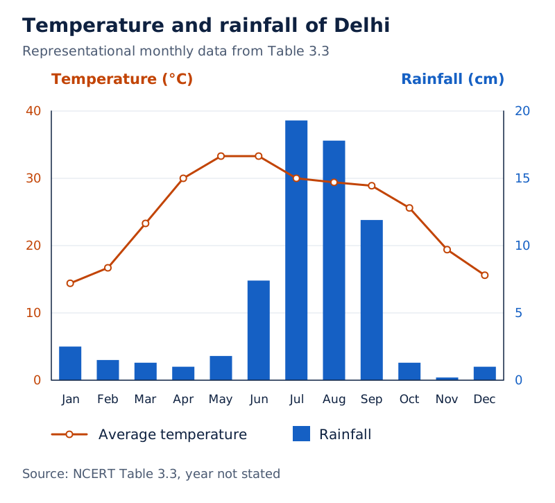
Months run along the horizontal axis. A red line represents temperature and blue bars represent rainfall. The temperature scale is on the left and the rainfall scale on the right; the tallest rainfall bar is July’s.
Drawn by One Young India. See Fig. 3.14 in your NCERT textbook
How can stations be compared?
Monthly patterns can also be compared with Chennai. Its October, November and December rainfall values are 30.6 cm, 35.0 cm and 13.9 cm, respectively. These months differ sharply from Delhi’s rainfall pattern and illustrate the importance of examining the seasonal distribution of rain.
To read such data, first identify the month, then the station and measurement. Keep temperature and rainfall units separate. Compare monthly values for timing and the annual entry for annual rainfall; neither measure alone describes the whole seasonal pattern.
Glossary
- Atmosphere — The blanket of air surrounding Earth, held around the planet by gravity.
- Altitude — The height of a location above mean sea level, usually measured in metres or feet.
- Troposphere — The lowest atmospheric layer, containing the air we breathe and nearly all weather phenomena.
- Stratosphere — The layer above the troposphere, containing ozone and extending up to 50 kilometres.
- Weather — The hour-to-hour and day-to-day conditions of the atmosphere at a place.
- Climate — Weather conditions and variations over a large area for an extended period, usually thirty years or more.
- Insolation — Incoming solar energy from the Sun that is intercepted by the Earth.
- Humidity — The presence of water vapour in the air, creating moisture in the atmosphere.
- Precipitation — Water falling from the atmosphere under gravity, including drizzle, rain, snow, sleet and hail.
- Atmospheric pressure — Pressure exerted by the weight of air on the surface of the Earth.
- Wind — The movement of air from a high-pressure area towards a low-pressure area.
- Monsoon — The seasonal reversal of wind direction that occurs during the course of a year.
- Climate change — Long-term changes in weather patterns, including temperature, rainfall and wind, caused mainly by human activities.
- Carbon footprint — The total greenhouse gases released through human activities, including energy use, transport and production.
Common errors and misconceptions
- Misconception: Oxygen is the most abundant atmospheric gas. Correct: Nitrogen accounts for 78%, while oxygen accounts for 21%.
- Misconception: Temperature decreases with height in every atmospheric layer. Correct: It decreases with altitude only in the troposphere and mesosphere; it rises very rapidly in the thermosphere.
- Misconception: Every weather phenomenon occurs in the troposphere. Correct: Nearly all weather phenomena occur there.
- Misconception: A few hot days establish a place’s climate. Correct: Weather describes short-term conditions; climate covers an extended period, usually thirty years or more.
- Misconception: Wind moves from low to high pressure. Correct: Wind moves from high-pressure areas towards low-pressure areas.
- Misconception: Sea breezes blow from land to sea at night. Correct: Sea breezes blow towards land during the day; land breezes blow towards the sea at night.
- Misconception: Winter monsoon winds bring no rainfall anywhere in India. Correct: They generally do not bring rain to most parts, but acquire moisture over the Bay of Bengal and bring rain to south-eastern regions.
- Misconception: Heavy rain alone explains the Punjab floods of 2025. Correct: Natural factors combined with weak embankments, construction close to rivers, silt accumulation and warning problems.
Exam-style questions with model answers
Q1. Weather describes hour-to-hour and day-to-day atmospheric conditions. Climate describes weather conditions and variations over a large area for an extended period, usually thirty years or more. Give two differences using these descriptions. [2 marks]
- Time span: Weather describes hour-to-hour and day-to-day conditions, whereas climate covers an extended period, usually thirty years or more.
- Scope: Weather describes atmospheric conditions at a place, whereas climate summarises weather conditions and variations over a large area.
Q2. In a hot area, air heats and rises. In a cooler area, cold, heavy air sinks. Air moves from high pressure to low pressure. Explain in three points how these conditions produce wind. [3 marks]
- Heating makes air rise over the hot area. This rising air creates a region of low pressure there.
- Over the cooler area, cold air is heavy and sinks. This sinking air produces a region of high pressure.
- Air then moves from the cooler high-pressure region towards the warmer low-pressure region. This movement of air is called wind.
Q3. During summer, India’s landmass heats faster than surrounding oceans. Low pressure develops over land, while the relatively cooler Indian Ocean has high pressure. Moist winds move from ocean to land, bringing rainfall between June and September. Explain this south-west monsoon mechanism in four points. [4 marks]
- The landmass of India heats faster than the surrounding oceans during summer, creating a contrast between land and sea temperatures.
- The heated land develops a low-pressure area over the Indian subcontinent.
- The Indian Ocean remains relatively cooler and has high pressure, providing the pressure difference needed for winds to move towards land.
- Moist winds blow from the ocean’s high pressure to the land’s low pressure, bringing south-west monsoon rainfall between June and September.
Q4. Use these facts to describe the five atmospheric layers in order: the troposphere averages about 12 km and contains nearly all weather; the stratosphere reaches 50 km and contains ozone that filters harmful solar radiation; the mesosphere reaches 80 km and burns up most incoming meteorites; the thermosphere extends from 80 to 700 km, heats rapidly and helps radio transmission; the uppermost exosphere has very thin air and loses light gases to space. Here km means kilometres. [5 marks]
- The troposphere is the lowest layer, with an average height of about 12 km. Nearly all weather phenomena occur in it.
- The stratosphere lies above it and extends up to 50 km. Its ozone layer helps protect Earth from harmful solar radiation.
- The mesosphere is the next layer, extending up to 80 km. Most meteorites entering from space burn up in this layer.
- The thermosphere extends from 80 to 700 km. Its temperature rises rapidly with altitude, and it helps with radio transmission.
- The exosphere is the uppermost layer and contains very thin air. Light gases float from this layer into space.
Q5. Punjab’s 2025 floods followed very heavy monsoon rain intensified by western disturbances. Rain also fell in Himachal Pradesh and Jammu and Kashmir; already high rivers received hill runoff and local rain. Weak old embankments failed to stop rising water, houses and farms reduced riverside space, silt reduced river and dam capacity, and warnings were late or unclear in some areas. Explain six contributing factors using this information. [6 marks]
- Very heavy monsoon rain supplied large amounts of water, while western disturbances intensified the rainfall by bringing additional moisture and rain.
- Rain in Punjab and neighbouring hill regions added water to already high rivers. Hill runoff and local rainfall caused them to overflow.
- Weak and old river embankments could not stop rising floodwater during the heavy monsoon rains, aggravating the flooding.
- Houses and farms too close to rivers reduced the natural space where floodwater could spread safely.
- Silt and mud accumulated in rivers and dams, reducing their capacity to hold and carry water.
- In some areas, flood warnings arrived late or were unclear. People were therefore unprepared, increasing the damage.
Q6. Delhi’s average temperatures in May and June are both 33.3°C; its July rainfall is 19.3 cm and August rainfall is 17.8 cm. Chennai’s October rainfall is 30.6 cm, compared with Delhi’s 1.3 cm. Here °C means degrees Celsius and cm means centimetres. State three comparisons from these data without calculating differences. [3 marks]
- Delhi has the same average temperature in May and June: both monthly values are 33.3°C, so neither month is warmer in these data.
- Delhi receives more rainfall in July than August. The supplied figures are 19.3 cm for July and 17.8 cm for August.
- Chennai receives more October rainfall than Delhi. Chennai’s value is 30.6 cm, whereas Delhi’s corresponding value is 1.3 cm.
Q7. Climate change means long-term changes in weather patterns caused mainly by human activities. Burning fossil fuels, deforestation and industrial pollution increase greenhouse gases, which trap heat. These raise global temperatures and contribute to more frequent floods and droughts, glacier melt and rising seas, affecting the natural environment and people. Responses include renewable energy, forest protection, energy saving and sustainable lifestyles. Explain the cause, mechanism, consequences and response to climate change in four points. [4 marks]
- Climate change is caused mainly by human activities, including burning fossil fuels, deforestation and industrial pollution that increase greenhouse gases.
- These gases trap heat in the atmosphere. Increased heat trapping raises global temperatures and changes long-term weather patterns.
- Consequences include more frequent floods and droughts, melting glaciers and rising sea levels, which affect the natural environment and people.
- Responses include using renewable energy, protecting forests, saving energy and adopting sustainable lifestyles to reduce greenhouse-gas releases.
Q8. A sea breeze blows from sea to land during the day, especially in the afternoon. A land breeze blows from land to sea at night. State the time and direction of each breeze. [2 marks]
- A sea breeze blows during the day, especially in the afternoon, and moves from the sea towards the land.
- A land breeze blows during the night and moves from the land towards the sea.
Key takeaways
- The atmosphere is held around Earth by gravity and contains mainly nitrogen and oxygen, with smaller quantities of other gases.
- The five layers are the troposphere, stratosphere, mesosphere, thermosphere and exosphere, distinguished by changes in temperature and density.
- Weather describes short-term atmospheric conditions; climate includes conditions and variations over a long period, usually thirty years or more.
- Air pressure decreases with altitude, and winds move from high-pressure areas towards low-pressure areas.
- India’s four main seasons are winter, summer, monsoon and post-monsoon, with regional differences in their conditions.
- The summer monsoon brings most of India’s annual rainfall, while the winter monsoon is important for south-eastern rainfall.
- Climate change is caused mainly by human activities; reducing carbon footprints requires energy saving, forest protection and sustainable lifestyles.
- The Punjab floods of 2025 resulted from natural and human-made factors, showing the importance of flood management and preparedness.
Test yourself
Which two gases dominate the atmosphere, and what are their percentages?
Nitrogen is the largest component at 78%, followed by oxygen at 21%.
What is the tropopause?
It is the transition zone that separates the troposphere from the stratosphere.
Why is the stratosphere ideal for aeroplanes?
It is free of clouds and other weather disturbances, making it ideal for flying aeroplanes.
Why do we not feel atmospheric pressure acting on us?
Air presses on us from all sides, while our bodies exert a counter-pressure that balances the outside pressure.
What is insolation?
Insolation is incoming solar energy from the Sun intercepted by the Earth.
Why can north-east monsoon winds bring rain to south-eastern India?
They pick up moisture while crossing the Bay of Bengal and bring rainfall to the eastern coast, especially Tamil Nadu, Andhra Pradesh and parts of Karnataka.
What distinguishes a carbon footprint from climate change?
A carbon footprint is the greenhouse gases released through human activities. Climate change means long-term changes in weather patterns, caused mainly by human activities.
Which human-made conditions worsened the Punjab floods?
Weak old embankments, houses and farms close to rivers, accumulated silt and mud, and late or unclear warnings in some areas increased flood damage.
Write about it
Turn a question from this chapter into a paper.
The Writing Studio has a structure guide, a rubric and citation tools for 15 formats, from essays to research papers. Drafting is free with an account. Learnacy Essential adds feedback from an AI writing coach and submission to The OYI Review.
Learnacy Essential is ₹1,499 for the year. Publication depends on review and is not guaranteed.