
Shaping of the Earth's Surface | CBSE Class 9 Geography Notes
On this page
This note covers the Earth's interior, moving plates, weathering and erosion, landforms made by rivers, waves, glaciers, wind and underground water, links between landforms and human activities, and the causes of landform-related disasters.
What lies inside the Earth, and how does it affect the surface?
A landform is a natural feature of the Earth's surface produced by processes that break down, move or deposit material, or move the Earth's crust. Mountains, valleys, plateaus, plains, deserts and coastal features are examples. The surface is continually changing.
How are the main layers arranged?
The crust is the outermost layer on which we live. Beneath it is the mantle, a very thick, hot layer. The core is the innermost layer and is extremely hot and heavy.
The lithosphere consists of the crust and the upper part of the mantle. This rigid outer layer is divided into plates. Beneath it lies the asthenosphere, a hot, mobile, semi-molten layer that allows these plates to move.
The mantle is mostly solid. The outer core is fluid and mainly consists of iron and nickel. The inner core is a solid, hot, spinning metal ball and the densest part of the Earth. These layers therefore differ in both position and physical condition.
What the figure shows
The Earth's interior
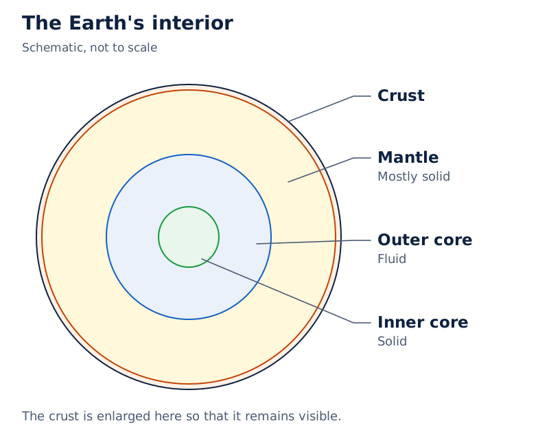
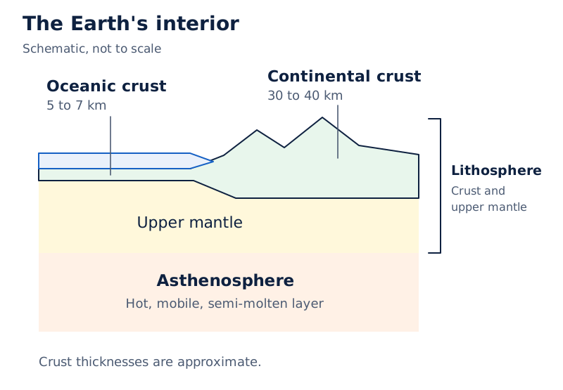
A cutaway globe and a wedge-shaped section label the crust, mantle, outer core and inner core. The wedge also distinguishes the lithosphere, asthenosphere, oceanic crust and continental crust. The given values are approximate.
Drawn by One Young India. See Fig. 2.1 in your NCERT textbook
The following measurements are approximate. km means kilometre, a unit of distance. The crust beneath continents is thicker than the crust beneath oceans; the ranges and the individual diagram labels are shown separately.
| Crust location | Thickness range | Diagram label |
|---|---|---|
| Under continents | 30 to 40 km | 30 km |
| Under the ocean | 5 to 7 km | 5 km |
| Layer or zone | Approximate labelled measurement |
|---|---|
| Lithosphere | 100 km |
| Asthenosphere | 200 km |
| Mantle | 2900 km |
| Outer core | 2200 km |
| Inner core | 1250 km |
What is plate tectonics, and why do plates move?
Plate tectonics, a theory given by W.J. Morgan, explains the movement of the Earth's crust. The outer layer is broken into large and small pieces called tectonic plates. These massive slabs of solid rock move very slowly, usually a few centimetres per year.
The plates move over the semi-molten layer beneath them. Their movement helps explain the formation of mountains, valleys and ocean basins, as well as earthquakes and volcanoes. An earthquake is a shaking of the Earth.
| Type of plate | What it carries |
|---|---|
| Continental plate | Continents |
| Oceanic plate | Ocean floors |
| Mixed plate | Both continents and oceans |
How do convection currents drive movement?
Convection currents are the continuous movements produced as hot material rises and cooler material sinks. Heat from the core drives these movements in the mantle. The resulting currents push and pull tectonic plates in different directions.
- Heat from the Earth's core heats material in the mantle.
- Hot molten material rises towards the crust.
- Cooler material sinks, maintaining continuous circulation in the mantle.
- These convection currents push and pull the plates, causing movement.
The major plates include the Pacific, Eurasian, African, North American, South American, Indo-Australian and Antarctic plates. The plate system helps explain how continents and oceans are distributed, as well as how the surface changes.
What the figure shows
Major tectonic plates
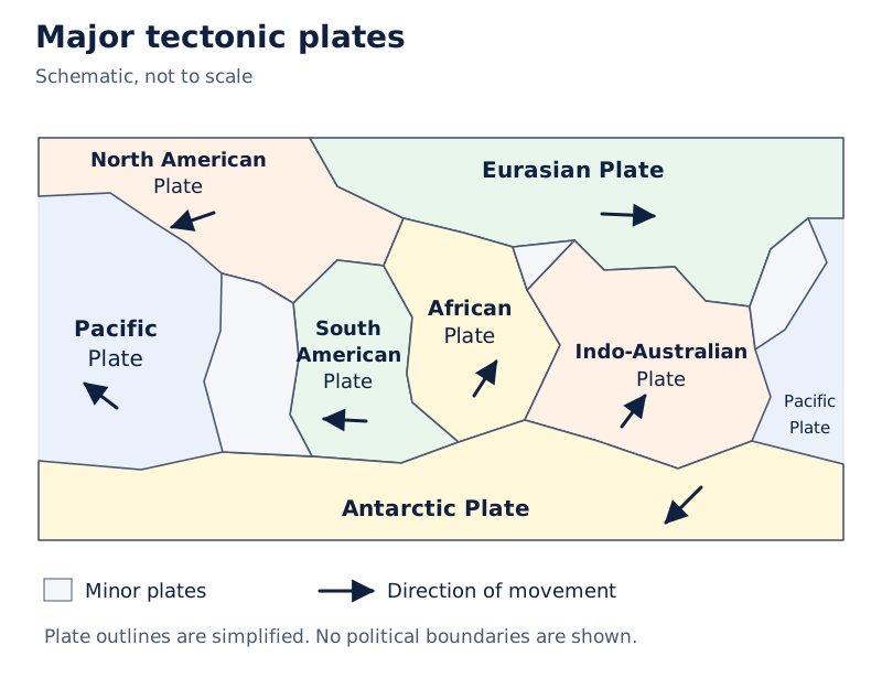
The world map colours and names the major plates, shows minor plates in grey and uses black arrows to indicate directions of movement. The Pacific Plate appears at both edges of the map.
Drawn by One Young India. See Fig. 2.3 in your NCERT textbook
Read plate names together with their boundaries and movement arrows. A plate boundary is an edge where plates meet. The direction of relative movement at that edge determines the type of boundary and helps explain the landforms and disturbances associated with it.
How do plate boundaries create landforms and earthquake zones?
There are three main types of plate boundary: convergent, where plates move towards each other; divergent, where they move apart; and transform, where they slide past each other. Each produces a different pattern of movement and surface change.
What happens at each boundary?
| Boundary | Movement and result | Example |
|---|---|---|
| Convergent | Continental plates collide and form fold mountains, mountains produced by the collision. | Himalaya |
| Divergent | Plates separate; magma, molten material from below, rises and forms new crust and ridges along the ocean floor. | Mid-Atlantic Ridge |
| Transform | Plates slide past each other without creating or destroying crust. This movement mainly causes earthquakes. | San Andreas Fault in the United States |
At a convergent boundary between an oceanic and a continental plate, the oceanic plate sinks beneath the continental plate. This movement leads to volcanic activity and earthquakes. The result differs from the formation of fold mountains when continental plates collide.
Most earthquakes and volcanoes occur along plate boundaries, especially around the Pacific Ocean. This area is called the Ring of Fire. Comparing the locations of plates with earthquake and volcano distributions reveals their close connection.
What the figure shows
Earthquakes and volcanoes
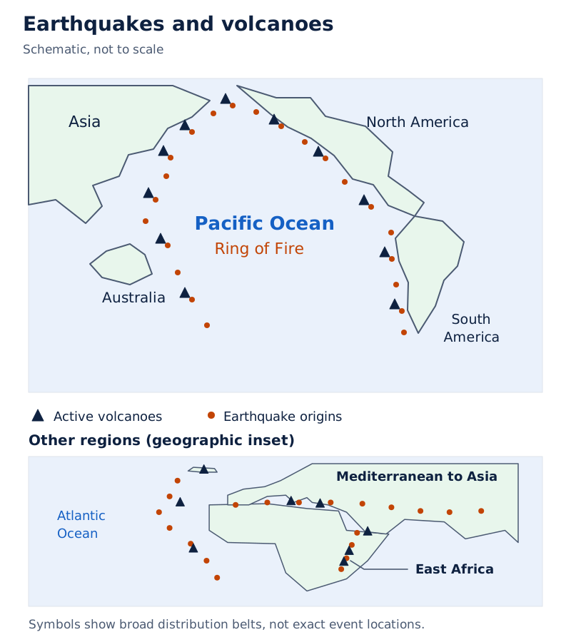
Black triangles represent active volcanoes and red dots represent earthquake origins. Dense belts of symbols surround much of the Pacific Ocean. Symbols also occur elsewhere, so the pattern does not mean that all events occur around the Pacific.
Drawn by One Young India. See Fig. 2.4 in your NCERT textbook
Case study: What does the Gujarat earthquake show?
The major earthquake in Gujarat in 2001 caused extensive damage. Photograph: The extensive damage caused by the major earthquake in Gujarat in 2001. Broken buildings and a large spread of rubble are visible. India has experienced major earthquakes resulting in thousands of deaths. A large earthquake in a densely populated country can severely damage life and the environment.
Understanding plate movement helps identify earthquake-prone and volcano-prone regions and manage related disasters. Here, disaster-prone means at risk of experiencing a disaster. Plate movement therefore connects the formation of landforms with the identification of regions exposed to these natural hazards.
How do weathering and erosion differ?
Definition: Weathering breaks rocks at the Earth's surface into smaller pieces without moving the broken material. Erosion wears away and carries soil, rocks and other surface material from one place to another.
The distinction is movement. Weathering breaks material down where it is. Erosion transports material through the action of water, wind, ice or waves. Over long periods, these processes work together to wear down mountains, carve valleys, form plains and shape varied landscapes.
What are the three types of weathering?
| Type | How it works |
|---|---|
| Physical weathering | Temperature changes, frost or wind break rocks into smaller pieces. |
| Chemical weathering | Minerals in rocks react with water, air or acids, producing new substances. |
| Biological weathering | Plants, animals or micro-organisms cause breakdown; roots growing into rock cracks can split rocks apart. |
Weathering also helps form soil. Its physical, chemical and biological forms describe different ways in which breakdown takes place. The growth of roots into a crack, for example, is biological weathering rather than the transport of the broken rock elsewhere.
Which agents cause erosion?
Water erosion is caused by rivers, rain or ocean waves. Wind erosion is common in dry, sandy areas. Glacial erosion occurs when moving ice scrapes and carries rocks. Coastal erosion involves sea waves wearing away land along the shore.
Erosion can both create and destroy surface features. For farmers, it removes fertile topsoil, the upper soil needed for crop growth, and lowers yields. Near rivers and coasts it can wash away land, houses and roads.
In construction and mining, erosion destabilises land and creates safety risks. Tourism and fishing also suffer because beaches, rivers and fertile lands may be destroyed. Erosion therefore affects both the physical landscape and the livelihoods that depend on it.
How do agents of gradation reshape land and support conservation?
Agents of gradation are natural forces that wear down, transport and deposit material, helping to level or smooth the surface over time. Deposition is the laying down of carried material. The main agents are running water, glaciers, wind, waves and groundwater.
Running water erodes rocks and soil to form valleys and plains. Glaciers, or moving masses of ice, scrape and carry material. Wind erodes and deposits sand. Sea waves reshape coastlines, while groundwater, water below the surface, dissolves rocks such as limestone.
These agents lower high areas and fill low areas. Their effects connect physical geography with human activity: fertile river plains support farming, coasts and harbours support trade and travel, and landforms influence settlements and cultural contacts.
How can soil and water be conserved?
Contouring uses trenches along contour lines on hillsides to slow, hold and allow rainwater to enter the ground. Contour lines follow equal heights. This helps prevent soil erosion and replenish groundwater.
Bunding uses earthen embankments along contour lines to slow surface run-off, the water flowing over land. It reduces erosion and increases water infiltration, or entry into soil, and soil moisture. Terracing creates level or gently sloping steps on a hillside to prevent erosion.
Case study: How does the Zabo system conserve soil and water?
The Zabo system in Nagaland is an integrated farming approach using earthen bunds on hillslopes for soil and water conservation. It illustrates how the management of sloping land can connect farming with the conservation of essential resources.
Check dams, barriers built across small streams, reduce water velocity, meaning its speed of flow. They slow the water, prevent soil erosion and allow sediment deposition. Sediment is material carried and laid down by agents such as water. Slower flow also enhances groundwater recharge.
These practices address the movement of soil and water together. Retaining water and reducing the removal of soil support land conservation, rather than treating erosion as a process that matters only for the appearance of the landscape.
How do rivers form waterfalls, meanders and deltas?
Rivers shape land through erosion, transportation, the carrying of material, and deposition. In their upper course, steep slopes and strong erosive forces often produce V-shaped valleys, waterfalls and rapids, stretches of fast-flowing water.
As a river loses energy, deposition becomes important. The middle course develops bends and floodplains, plains associated with river flooding. In the lower course, the river slows further and deposits large amounts of material. Different parts of a river therefore show different combinations of erosion and deposition.
How does a waterfall develop?
A waterfall is a steep or vertical drop over which a river flows. In the upper course, hard rocks resist erosion while softer rocks below are worn away, creating a sudden drop.
Waterfalls attract tourists and support local economies through recreation, trekking and photography. They are sometimes used for hydroelectric power, electricity generated by harnessing the force of water. They often have cultural or religious significance in certain regions.
What happens on the banks of a meander?
A meander is a winding bend in the middle or lower course. Lateral erosion means sideways erosion of the river banks. The outer bank is eroded while sediment is deposited on the inner bank, gradually producing large loops.
Fertile deposits along meanders support farming. Villages and towns often develop on nearby gentle slopes. Meandering rivers can support navigation, irrigation and, in some cases, tourism. The Grand Anicut, also called Kallanai, in Tamil Nadu illustrates the use of rivers for irrigation.
How does a delta grow?
- A river carries sediment from its upstream course towards its mouth, the place where it enters another water body.
- At the mouth, it enters a sea, ocean or lake.
- The river deposits the sediment it has transported.
- Deposits accumulate over time into a fan-shaped or triangular area of land called a delta.
Deltas have fertile alluvial soil, soil formed from river deposits, which supports crops such as rice and jute. Mixing fresh and saltwater supports diverse aquatic life and fishing. Many deltas support dense settlements, trade and transport, but they can also be prone to flooding.
What the figure shows
Delta
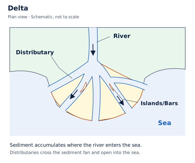
The drawing shows a river dividing into distributaries, branches flowing away from the main river, around islands or bars of deposited material before entering the sea. The labels are River, Distributary, Islands/Bars and Sea.
Drawn by One Young India. See Fig. 2.12 in your NCERT textbook
How do waves and currents shape coasts?
Waves and currents are movements of water over the oceanic surface. They reshape the coastal zone through erosion and deposition. Their landforms include beaches, sand bars, cliffs, caves, arches and stacks. The same coast can contain both deposited material and eroded rock features.
How are beaches useful?
A beach is an accumulation of sand, pebbles or rocks along the shore of a sea, ocean or lake. Waves deposit sediment, while wave action, tides and currents continually move and reshape it. Tides are changes between high and low sea-water levels.
Beaches support tourism, swimming and recreation, boosting local economies. They provide fishing areas, and some communities collect sand and shells there. Beaches also act as natural barriers against strong waves and coastal erosion, helping safeguard nearby settlements.
Which features develop through coastal erosion?
| Feature | Formation |
|---|---|
| Sea cliff | A steep rock face formed as waves undercut the base of the coast. |
| Wave-cut platform | A flat area left behind as a cliff retreats. |
| Sea cave | A hollow formed where waves erode weaker parts of coastal rock. |
| Sea arch | An opening created when caves on opposite sides of a headland, land projecting into the sea, meet. |
| Sea stack | An isolated rock pillar remaining after an arch collapses. |
What the figure shows
Sea arch and sea stack
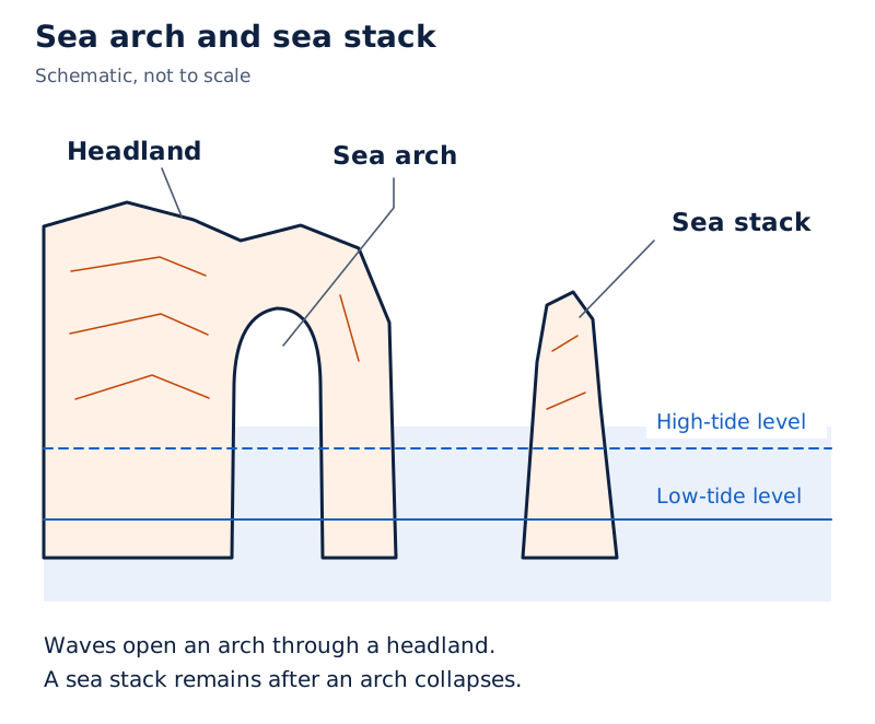
A drawing and photograph show an arch through a coastal rock mass and a separate standing pillar. The drawing labels the headland, sea arch, sea stack, high-tide level and low-tide level.
Drawn by One Young India. See Fig. 2.15 in your NCERT textbook
These features influence human use of the coast. Some are important for tourism, while other coastal areas may need protection to safeguard settlements. The benefits of coastal landscapes therefore exist alongside the possibility of land loss through erosion.
How do glaciers erode valleys and deposit moraines?
Glacial erosion occurs as glaciers slowly move across the land, scraping and carrying material. Their movement widens and deepens river valleys into U-shaped valleys. Glaciers also produce distinctive hollows, ridges and coastal inlets.
| Erosional feature | Meaning |
|---|---|
| Cirque | A bowl-shaped depression at the head of a glacier. |
| Arete | A sharp ridge between valleys. |
| Hanging valley | A valley occurring where a smaller glacier meets a larger one. |
| Fjord | A deep, narrow inlet formed when the sea floods a glacial valley. |
U-shaped valleys and cirques often attract trekking, skiing and mountaineering. Fjords provide harbours and fishing areas. In some valleys, fertile glacial soil supports agriculture. Glaciers also supply fresh water to rivers that sustain people downstream.
How do the types of moraine differ?
Till consists of rocks, soil and debris carried by glaciers. Moraines are landforms formed when glaciers melt and deposit this material. They are depositional features, unlike valleys carved by moving ice.
- Lateral moraines form along the sides of glaciers.
- Terminal moraines occur at glacier ends and mark their furthest advance.
- Medial moraines form when two glaciers meet and their lateral moraines join in the middle.
What the figure shows
Moraines
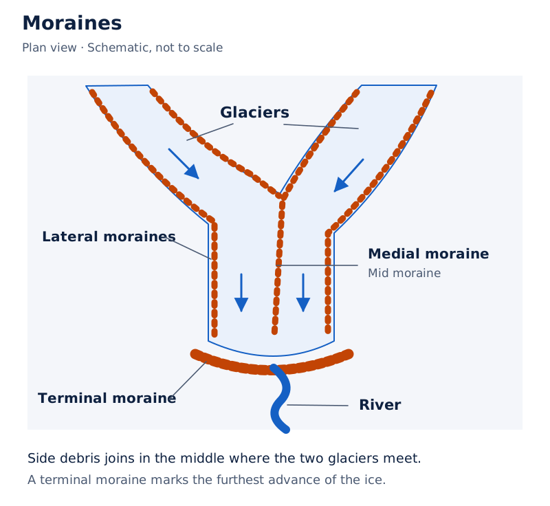
The drawing labels material along glacier sides, a central feature called “Mid moraine”, a terminal moraine and a river beyond the ice. The neighbouring photograph shows long dark bands across a glacier.
Drawn by One Young India. See Fig. 2.19 in your NCERT textbook
Moraines often create fertile soil for farming. They can also form natural dams and lakes used for water supply, irrigation and sometimes hydroelectric power. Thus, the material left behind by ice can matter as much to human activity as the valleys cut by it.
How does wind create desert landforms and dunes?
Wind erosion occurs when strong winds pick up and carry loose sand and soil. It changes dry landscapes by removing fine material and wearing down rock. Wind also deposits sand, so erosion and deposition create different kinds of landforms.
Which landforms result from wind erosion?
- Yardangs are streamlined rock ridges carved by wind.
- Ventifacts are rocks polished and shaped by sandblasting, the action of wind-driven sand against rock.
- Deflation hollows, also called blowouts, are shallow depressions where loose material has been removed.
- Desert pavements are flat surfaces remaining after finer particles have been blown away.
These features influence settlement and farming in arid regions, meaning dry regions. Yardangs and ventifacts attract tourists and geologists, people who study the Earth and its rocks, because of their distinctive desert forms.
How do dune shapes differ?
Dunes are hills or ridges of wind-deposited sand in deserts or along sandy coasts. Their shapes reflect conditions such as sand supply, wind direction and vegetation.
| Dune type | Shape and conditions |
|---|---|
| Barchan | Crescent-shaped; forms with limited sand and a single wind direction. |
| Longitudinal | A long ridge parallel to the prevailing, or dominant, wind. |
| Star | Multiple arms; forms where winds arrive from different directions. |
| Parabolic | U-shaped; often stabilised by vegetation. |
Dunes act as natural barriers against desertification, the development of desert-like conditions, and wind erosion. They support tourism and adventure sports. In some coastal regions, dunes protect settlements from strong sea winds and waves. Their sand is sometimes used for construction.
How does underground water create caves and other karst features?
Karst topography is the set of landforms produced by underground water through chemical weathering and erosion, especially in limestone or other soluble rocks. Soluble means capable of dissolving. Here, the action of water below the surface creates both underground and surface features.
Which features occur in a cave system?
Caves are hollow spaces formed as acidic water dissolves rock. Stalactites are icicle-shaped formations hanging from cave ceilings. Stalagmites rise from cave floors. Remembering the direction of growth helps distinguish the two features.
Sinkholes, also called dolines, are depressions formed when ground collapses into an underground cavity. Underground rivers flow through cave systems. The collapse that creates a sinkhole differs from a river simply flowing through an existing hollow.
What the figure shows
Cave features
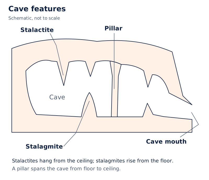
The cave drawing labels a stalactite hanging from above, a stalagmite rising from below, a pillar spanning the cave, the cave itself and its mouth. An accompanying photograph shows formations inside a lit cave.
Drawn by One Young India. See Fig. 2.24 in your NCERT textbook
Why do these landforms matter to people?
Caves and underground rivers provide sources of fresh water and opportunities for tourism. In some cases, they also have cultural or religious significance. Stalagmites and stalactites attract geologists and adventurers, giving caves importance for study and recreation.
The central process is the interaction of water with rock that can dissolve. The resulting landscape should therefore be distinguished from wind-carved ridges or ice-carved valleys. Each involves a different agent and a different way of changing the Earth's surface.
What makes slopes unstable and causes landslides?
A landslide involves the failure and movement of material on an unstable slope. Its causes combine natural conditions with human disturbance. Heavy, continuous rainfall is one of the main natural causes because water enters soil and rock.
How can rainfall and disturbance trigger failure?
- Heavy and continuous rain allows water to seep into soil and rocks on a slope.
- The added water increases the weight of this material.
- Water reduces friction, the resistance that helps oppose movement.
- The weakened slope can fail, allowing material to move downslope.
Earthquakes and volcanic eruptions can trigger landslides by shaking the ground and weakening slopes. Steep slopes and loose or weathered rocks further increase risk. Several conditions can therefore contribute to the same slope becoming unstable.
Deforestation, the removal of forest cover, mining, road construction and unplanned hillside construction disturb the natural balance. Poor drainage and improper land use allow excess water to accumulate and contribute to sudden slope failure.
Which precautions help reduce landslide risk?
Mitigation means measures that reduce disaster risk or harm. Growing trees that hold soil together and keeping drains clean are protective steps. Construction should be avoided near steep slopes and drainage paths.
Warning signs include sinking buildings, cracks in rocks and muddy river water. Listen to alerts and remain aware of these changes. Unusual sounds, such as trees cracking or boulders knocking together, are also warning signs to take seriously.
During danger, stay calm, stay with companions and move quickly away from the landslide path or downstream valley. These precautions connect awareness of slope behaviour with action to protect people exposed to it.
How do avalanches and glacial lake outburst floods develop?
An avalanche is a sudden movement of unstable snow on a steep mountain slope. Heavy snowfall over a short period adds weight to the snowpack, the accumulated snow, especially where it rests on weak or loosely bonded layers.
What can disturb a snow-covered slope?
A sudden temperature rise can partially melt snow and reduce the friction holding it together. Strong winds may pile snow unevenly and create fragile layers. Earthquakes, vibrations and human activities such as skiing, trekking or mountain construction can disturb the balance and trigger avalanches.
What happens when a glacial lake's dam fails?
A Glacial Lake Outburst Flood, abbreviated GLOF, is the sudden release of large volumes of water from a glacial lake. Natural dams made of ice or loose moraines hold back the lake water, but natural and climatic factors can cause failure.
- Rising temperatures cause rapid glacier melting, enlarging glacial lakes and raising their water levels.
- The increased water puts pressure on natural dams of ice or loose moraines.
- Heavy rainfall or intense snowfall can add excess water; earthquakes, avalanches or landslides may strike a lake or weaken its dam.
- If the dam collapses, stored water is released abruptly, causing destructive flooding downstream.
Case study: What were the effects of the Chamoli flood?
In February 2021, a devastating flood struck Chamoli district in Uttarakhand. Many people and livestock died. Buildings, roads, bridges and hydel projects, projects producing hydroelectric power, suffered severe damage. Connections to villages were also adversely affected.
This event illustrates how a sudden flood can disrupt lives, transport and power infrastructure together. The effects extend beyond the water itself to the settlements and activities linked by roads, bridges and other facilities.
Why do dust storms occur in dry regions?
A dust storm occurs when strong winds lift large quantities of loose, dry soil and sand into the air. Dust storms are common in deserts and semi-arid regions, regions with limited rainfall, where soil is loose and dry.
How do rainfall and vegetation affect exposure?
Prolonged drought, an extended period of inadequate rainfall, and low rainfall dry the soil. Fine particles then become easier for wind to lift. Strong winds and an exposed, dry surface work together to create the conditions for dust storms.
Sparse vegetation cover, often due to deforestation, overgrazing, excessive grazing of vegetation, or poor farming practices, leaves the ground exposed. Human use of land can therefore contribute to conditions in which wind carries surface material away.
Climate change and extreme weather conditions can further increase the frequency and intensity of dust storms. This is a qualified relationship: these influences can worsen storms, while loose material, dry conditions and strong winds remain central to the process.
Dust storms connect the study of disasters with wind erosion. Both involve wind lifting and carrying loose material. Understanding that connection also explains why the condition of soil and vegetation matters to the people who depend on dry-region land.
Glossary
- Lithosphere — The rigid outer layer consisting of the crust and upper mantle, divided into tectonic plates.
- Asthenosphere — The hot, mobile, semi-molten layer beneath the lithosphere that permits plate movement.
- Convection currents — Circulating movements produced when hot mantle material rises and cooler material sinks.
- Plate boundary — An edge where tectonic plates meet and move relative to one another.
- Weathering — Breakdown of surface rocks into smaller pieces without movement of the broken material.
- Erosion — Wearing away and transport of surface material by agents such as water, wind or ice.
- Agents of gradation — Natural forces that wear down, transport and deposit material, gradually levelling the Earth's surface.
- Meander — A winding river bend shaped by outer-bank erosion and inner-bank sediment deposition.
- Delta — A fan-shaped or triangular deposit of river sediment accumulated at a river's mouth.
- Moraine — A landform made of rocks, soil and debris deposited by a melting glacier.
- Barchan dune — A crescent-shaped dune formed where sand is limited and wind comes from one direction.
- Karst topography — Landforms created by underground water through chemical weathering and erosion, especially in soluble rocks.
- Stalactite — An icicle-shaped formation that hangs down from the ceiling of a cave.
- Stalagmite — A cave formation that rises upwards from the floor rather than hanging from the ceiling.
- Glacial Lake Outburst Flood — A sudden release of large volumes of glacial lake water, producing destructive flooding downstream.
Common errors and misconceptions
- Misconception: The entire mantle is liquid. Correct: The mantle is mostly solid; the asthenosphere is a hot, mobile, semi-molten layer beneath the lithosphere.
- Misconception: All plate boundaries create new crust. Correct: New crust forms at divergent boundaries; transform boundaries neither create nor destroy crust.
- Misconception: Every earthquake and volcano lies on a plate boundary. Correct: Most occur along plate boundaries, especially around the Pacific Ring of Fire.
- Misconception: Weathering includes carrying rock fragments away. Correct: Weathering breaks rocks without moving the fragments; erosion involves transport.
- Misconception: A meander deposits sediment on its outer bank. Correct: The outer bank is eroded and the inner bank receives sediment.
- Misconception: Moraines are valleys eroded by glaciers. Correct: Moraines are deposited material; U-shaped valleys result from glacial erosion.
- Misconception: Stalactites grow from cave floors. Correct: Stalactites hang from ceilings, whereas stalagmites rise from floors.
- Misconception: Dunes are rock ridges carved by wind erosion. Correct: Dunes are hills or ridges of deposited sand; yardangs are rock ridges carved by wind.
Exam-style questions with model answers
Q1. Rocks break into fragments without changing location; elsewhere, a river carries fragments away. Identify the two processes and give their distinguishing feature. [2 marks]
- The rocks breaking without changing location undergo weathering, which does not transport the broken material.
- The river carrying fragments away causes erosion, which includes movement of surface material from one place to another.
Q2. A diagram gives approximate crust thicknesses of 30 to 40 km under continents and 5 to 7 km under the ocean, where km means kilometre. Identify the thicker crust and reproduce both ranges without calculating new values. [2 marks]
- Continental crust is thicker, with an approximate thickness range of 30 to 40 km beneath continents.
- Oceanic crust is thinner, with an approximate thickness range of 5 to 7 km beneath the ocean.
Q3. Compare convergent, divergent and transform plate boundaries in three points, giving movement and outcome for each. [3 marks]
- At convergent boundaries, plates move towards one another. Colliding continental plates form fold mountains; an oceanic plate sinking beneath a continental plate leads to volcanic activity and earthquakes.
- At divergent boundaries, plates move apart. Magma rises from below, forming new crust and features such as mid-ocean ridges.
- At transform boundaries, plates slide past each other without creating or destroying crust. This movement mainly causes earthquakes.
Q4. Explain in four points how a meander forms and supports human activity. Include the actions on both banks and two human uses. [4 marks]
- A meander is a winding bend in a river's middle or lower course. The flowing water erodes the outer banks of its bends.
- On the inner banks, sediment is deposited. Together, sideways erosion and deposition gradually create large loops in the river's course.
- The fertile soil deposited along meander banks supports agriculture, making these areas suitable for farming.
- Meandering rivers can provide irrigation water. Their role in supplying fields connects river processes with the work and livelihoods of farmers.
Q5. Describe five coastal landforms created by erosion and explain how each forms. [5 marks]
- Sea cliffs are steep rock faces along the coast. They develop when waves undercut the base of coastal land, shaping an abrupt rock face.
- Wave-cut platforms are flat areas left behind as cliffs retreat. They show how erosion can change both the position and shape of a coastline.
- Sea caves form where waves erode weak portions of coastal rock. Continued action creates hollow spaces within the rock.
- Sea arches develop when caves on opposite sides of a headland meet. Their meeting creates an opening through the projecting coastal land.
- Sea stacks are isolated pillars of rock. They remain standing after the collapse of arches, forming separate features of the eroded coastal landscape.
Q6. Explain in five points how a glacial lake can produce a Glacial Lake Outburst Flood, or GLOF. Include lake growth, pressure on the dam, additional water, disturbances and downstream effects. [5 marks]
- Rapid melting of glaciers because of rising temperatures increases the size and water level of glacial lakes.
- As the lake grows, its water places pressure on the natural dam holding it back. Such dams consist of ice or loose moraines.
- Heavy rainfall or intense snowfall can add excess water to a glacial lake, contributing to the conditions that threaten the dam.
- Earthquakes, avalanches or landslides may strike the lake or weaken its dam. These disturbances can lead to the dam's sudden collapse.
- When the dam fails, large amounts of stored water are released abruptly. The sudden release causes destructive floods in downstream areas.
Q7. In February 2021, a flood in Chamoli district, Uttarakhand, killed people and livestock, severely damaged buildings, roads, bridges and hydel projects, and adversely affected village connectivity. Hydel projects generate hydroelectric power. Group these supplied effects into three impacts on human life and activity. [3 marks]
- The flood caused loss of human life and livestock. These losses directly affected the people and animals living in the affected area.
- Damage to roads and bridges, together with the reported disruption of village connectivity, affected links between settlements.
- Buildings and hydel projects suffered severe damage. The impact therefore extended to built structures and the infrastructure used to generate hydroelectric power.
Q8. Explain three factors that help produce dust storms: dry soil, sparse vegetation and strong winds. [3 marks]
- Prolonged drought and low rainfall dry out the soil. Fine particles then become easier for wind to pick up from the surface.
- Sparse vegetation leaves land exposed, often because of deforestation, overgrazing or poor farming practices. Exposed loose soil contributes to conditions favourable for dust storms.
- Strong winds lift large amounts of loose, dry soil and sand into the air. This movement of surface particles produces a dust storm.
Key takeaways
- The crust and upper mantle form the lithosphere, whose plates move over the semi-molten asthenosphere beneath it.
- Convection currents push and pull tectonic plates; convergent, divergent and transform boundaries produce different movements and consequences.
- Most earthquakes and volcanoes occur along plate boundaries, especially around the Pacific Ocean's Ring of Fire.
- Weathering breaks rocks without transporting them; erosion wears away and moves material through natural agents.
- River bends combine outer-bank erosion with inner-bank deposition, while accumulating sediment at river mouths forms deltas.
- Waves erode coastal cliffs, caves, arches and stacks, while deposition produces beaches used for recreation and fishing.
- Glaciers erode valleys and deposit moraines; wind creates erosional features and deposits sand in different dune shapes.
- Underground water dissolves soluble rock to create karst features, including caves, sinkholes and underground river systems.
- Landslides, avalanches, glacial lake outburst floods and dust storms link physical conditions with risks to human life and activity.
Test yourself
What is included in the lithosphere?
The lithosphere includes the Earth's crust and the upper part of its mantle.
Which boundary forms new crust as plates separate?
A divergent boundary forms new crust when magma rises between plates moving apart.
How does biological weathering split a rock?
Plant roots can grow into cracks and split rocks apart as an example of biological weathering.
Which bank of a meander receives deposited sediment?
Sediment is deposited on the inner bank, while the outer bank is eroded.
What remains when a sea arch collapses?
An isolated pillar of rock called a sea stack remains after the arch collapses.
Where do medial moraines form?
They form in the middle where two glaciers meet and their lateral moraines join.
Which dune forms with limited sand and one wind direction?
A barchan dune forms under these conditions and has a crescent shape.
How do stalactites differ from stalagmites?
Stalactites hang from cave ceilings, while stalagmites rise from cave floors.
Write about it
Turn a question from this chapter into a paper.
The Writing Studio has a structure guide, a rubric and citation tools for 15 formats, from essays to research papers. Drafting is free with an account. Learnacy Essential adds feedback from an AI writing coach and submission to The OYI Review.
Learnacy Essential is ₹1,499 for the year. Publication depends on review and is not guaranteed.