
Water (Oceans) | CBSE Class 11 Geography Notes
On this page
Watch & explore
Start with a few high-quality watches, then dive into the notes below.
This note covers the hydrological cycle, water storage and circulation, major and minor features of the ocean floor, factors controlling ocean temperature, horizontal and vertical temperature distribution, salinity and its controls, regional salinity contrasts, and the layering of ocean water.
What is the hydrological cycle and how does water circulate?
Earth has abundant water on its surface and is called the Blue Planet. Water is essential to life and is a cyclic resource: it can be used and re-used. Its distribution is uneven, with plentiful supplies in some places and very limited quantities in others.
Definition: The hydrological cycle is the circulation of water within the hydrosphere, the earth's water realm, in liquid, solid and gaseous forms. It includes continuous exchange between oceans, atmosphere, land surface, subsurface and organisms.
What connects the different water stores?
A water store holds water, while a process transfers it or changes its form. Stores include oceans, ice and snow, groundwater, lakes, soil moisture, meaning water held in soil, the atmosphere, streams and living organisms. Groundwater is water held below the land surface.
- Evaporation, the change of liquid water into water vapour, transfers water from oceans and other surfaces into the atmosphere. Evapotranspiration combines evaporation with the release of water vapour by plants.
- Condensation, the change of water vapour into liquid water, forms part of the atmospheric return pathway. Precipitation is water falling from the atmosphere to the earth's surface.
- Runoff carries water across the land surface. Stream flow and snowmelt runoff link water stored on land with moving water in streams.
- Infiltration is water entering the ground. Underground flow, groundwater discharge (water leaving underground storage) and springs (natural outlets of groundwater) connect subsurface storage with other parts of the cycle.
Sublimation, the direct change of ice or snow into water vapour, is another process in the water cycle. Water therefore circulates through different stores and physical states, rather than following a single surface route from the land to the sea.
What the figure shows
Hydrological cycle
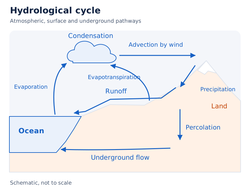
Mountains, clouds, land and an ocean are linked by arrows. Labels identify evaporation, evapotranspiration, condensation, precipitation, runoff, percolation (movement of water through soil) and underground flow. Transport by wind is labelled advection, meaning transport from one place to another.
Drawn by One Young India. See Fig. 12.1 in your NCERT textbook
The diagram brings atmospheric, surface and underground routes together, showing how the ocean and land participate in the same circulating system.
How can water be renewable while water crises still occur?
A renewable resource is replenished through natural processes. The hydrological cycle continuously exchanges water between its stores, but this does not mean that every place receives an adequate supply. Availability varies across places and over time.
How do storage and circulation differ?
| Water store or setting | Related processes |
|---|---|
| Oceans and other evaporating surfaces | Evaporation transfers water towards the atmosphere. |
| Atmosphere | Condensation and precipitation participate in the return of water to the surface. |
| Ice and snow | Snowmelt runoff supplies streams; sublimation transfers water into its gaseous phase. |
| Land surface and streams | Surface runoff and stream flow move water across land. |
| Groundwater | Infiltration supplies subsurface water, while discharge and springs provide routes out of storage. |
Water falling on land has different possible destinations. It can return to the atmosphere, run off over the surface, infiltrate into the ground or become part of a glacier, a mass of ice on land. These pathways connect storage with movement.
Why does circulation not remove scarcity?
The amount of renewable water on earth remains constant while demand is increasing tremendously. This creates water crises both spatially, meaning across different places, and temporally, meaning at different times. River-water pollution further aggravates the crisis.
The distinction between quantity and quality is therefore important. Increasing demand places pressure on the available quantity, while pollution worsens water quality. A continuously operating water cycle can coexist with serious problems of water availability.
Note: “Cyclic” describes repeated circulation and use. It does not mean that supplies are evenly distributed or that rising demand and river pollution cease to matter.
What are the major divisions of the ocean floor?
Ocean-floor relief means the varied shapes and elevations of the land beneath ocean water. Oceans occupy great depressions in the earth's outer layer. Their floors include mountain ranges, trenches and plains, with complexity comparable to relief on land.
These features result from tectonic processes, involving movements of the earth's crust; volcanic processes, involving volcanic activity; and depositional processes, involving the laying down of material. Ocean floors are rugged, despite being hidden beneath water.
How is the oceanic area divided?
The five oceans are the Pacific, Atlantic, Indian, Southern and Arctic oceans. They merge naturally into one another, making their boundaries difficult to demarcate. Seas, bays, gulfs and other inlets form parts of the oceanic waters.
A major portion of the ocean floor lies between 3 and 6 kilometres below sea level. The symbol km means kilometres and m means metres. Depth below sea level must be distinguished from a feature's height above the surrounding seabed.
| Major division | Defining feature | Depth or relief information |
|---|---|---|
| Continental shelf | Submerged edge of a continent occupied by relatively shallow seas and gulfs | May be as shallow as 30 m or as deep as 600 m |
| Continental slope | Steep connection between the shelf and ocean basin, the large depression occupied by ocean water | Depth varies between 200 and 3,000 m |
| Deep sea plain | Gently sloping, very flat and smooth basin floor | Depth varies between 3,000 and 6,000 m |
| Oceanic deeps or trenches | Relatively steep-sided, narrow basins | Some 3 to 5 km deeper than the surrounding floor |
The four major divisions provide a broad framework. Smaller features, such as underwater mountains and valleys, add variety within the ocean floor. Their names describe different forms, rather than interchangeable parts of one uniform plain.
How do continental shelves and continental slopes differ?
The continental shelf is the extended edge of a continent beneath relatively shallow seas and gulfs. It is the shallowest part of the ocean. Its average gradient, meaning its inclination, is 1° or even less; the symbol ° means degrees.
The shelf typically ends at a very steep slope called the shelf break. The continental slope begins where the shelf bottom drops sharply and connects the shelf to the ocean basin. The slope boundary indicates the end of the continents.
What measurements distinguish the two?
| Characteristic | Continental shelf | Continental slope |
|---|---|---|
| Gradient | Average of 1° or even less | Varies between 2° and 5° |
| Depth | May range from as shallow as 30 m to as deep as 600 m | Varies between 200 and 3,000 m |
| Position | Extended margin of a continent | Connection between shelf and ocean basin |
| Associated features | Variable thicknesses of sediment | Canyons and trenches |
Case study: How does shelf width vary between coasts?
The average width of continental shelves is about 80 km. However, shelves are almost absent or very narrow along some margins, including the coast of Chile and the west coast of Sumatra. The average therefore does not describe every coast.
The Siberian shelf in the Arctic Ocean is the world's largest and stretches to 1,500 km in width. Its contrast with Chile and western Sumatra demonstrates the large variation between continental margins.
Why are shelf sediments significant?
Sediments are deposited materials. Rivers, glaciers and wind bring them from land, and waves and currents distribute them over continental shelves. The covering varies in thickness. Massive sedimentary deposits accumulated over a long time become a source of fossil fuels, fuels derived from ancient organic material.
Shelf width, shelf depth and gradient describe different characteristics. A broad shelf is not defined by a greater depth, and the average width should not be substituted for the depth range.
How do deep sea plains, trenches and minor relief features compare?
Deep sea plains are gently sloping parts of ocean basins at depths between 3,000 and 6,000 m. They are the flattest and smoothest regions of the world. Fine-grained sediments, including clay and silt, cover their surfaces.
Oceanic deeps or trenches are the deepest parts of the oceans. These relatively steep-sided, narrow basins are some 3 to 5 km deeper than the neighbouring ocean floor. Their extra depth is measured relative to that surrounding floor.
Why are trenches significant?
Trenches occur at the bases of continental slopes and along island arcs, curved chains of islands. They are associated with active volcanoes and strong earthquakes, making them significant for understanding plate movements, the movements of large sections of the earth's outer shell.
The explored deeps total 57: 32 in the Pacific Ocean, 19 in the Atlantic Ocean and 6 in the Indian Ocean. This count concerns explored deeps; it should not be turned into a claim that no other deeps exist.
Which features rise above or cut into the seabed?
| Feature | Shape and character | Example or detail |
|---|---|---|
| Mid-oceanic ridge | Two mountain chains separated by a large depression | Peaks can reach 2,500 m in height; some emerge above the ocean. Iceland forms part of the mid-Atlantic Ridge. |
| Seamount | Volcanic mountain with pointed summits that does not reach the ocean surface | Can be 3,000 to 4,500 m tall; the Emperor seamount extends the Hawaiian Islands in the Pacific. |
| Submarine canyon | Deep underwater valley, sometimes cutting across shelves and slopes | Often extends from a large river mouth; the Hudson Canyon is the best known. |
| Guyot | Flat-topped seamount showing evidence of gradual subsidence, or sinking | More than 10,000 seamounts and guyots are estimated to exist in the Pacific alone. |
| Atoll | Low tropical ocean island with coral reefs surrounding a central depression | The depression may contain a lagoon, a part of the sea, or sometimes fresh, brackish or highly saline water. |
Coral reefs are structures built by corals. Brackish water is water with a salt content between freshwater and seawater; saline means containing dissolved salts. These descriptions distinguish the central water of an atoll from the surrounding reef.
What the figure shows
Relief features of ocean floors
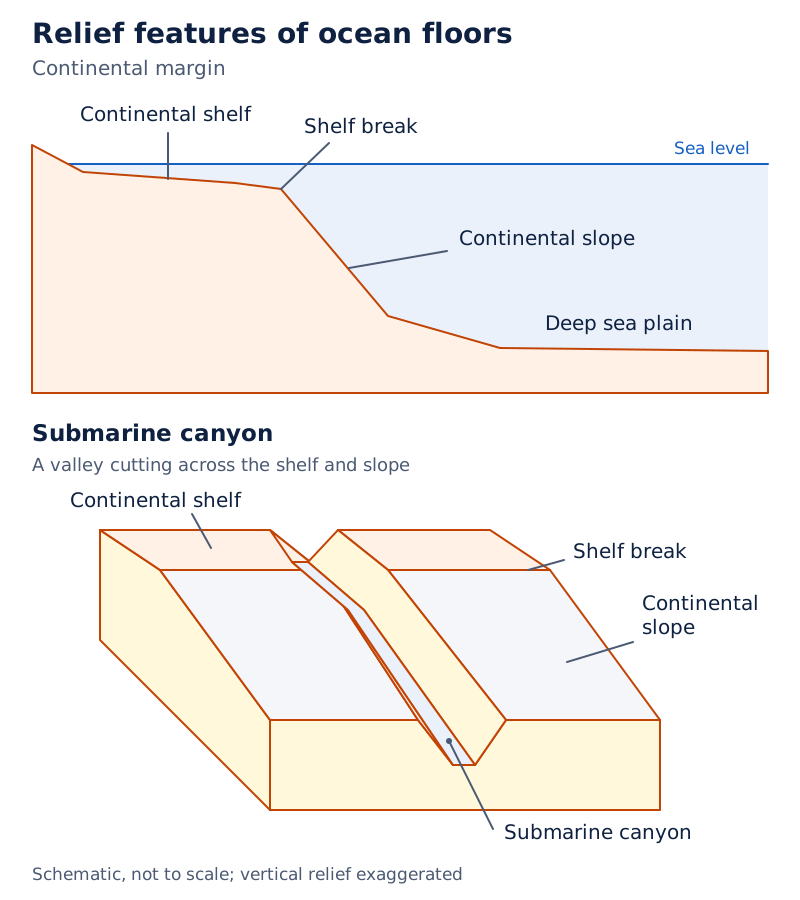
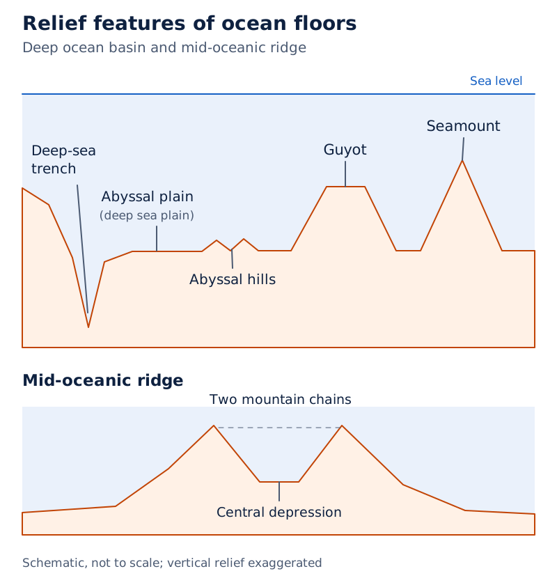
Three block drawings show a continental margin, a deep ocean basin and a mid-ocean ridge. The margin labels include continental shelf, shelf break, continental slope and submarine canyon. The basin distinguishes a deep-sea trench, an abyssal plain (deep sea plain), abyssal hills (hills on the deep ocean floor), a guyot and a seamount.
Drawn by One Young India. See Fig. 12.2 in your NCERT textbook
Some submarine canyons are comparable to the Grand Canyon of the Colorado river. Their valley form distinguishes them from seamounts and guyots, which are mountains. A guyot's flat summit is its central identifying feature.
What factors control the temperature of ocean waters?
Ocean waters receive solar energy, energy from the sun, just as land does. However, ocean water heats and cools more slowly than land. Its temperature varies both across the surface and downward through the water column.
How do the four main controls operate?
- Latitude, angular distance north or south of the equator, affects the solar energy received. Surface temperature decreases towards the poles because insolation, incoming solar radiation, decreases poleward.
- Unequal distribution of land and water affects the two hemispheres, the northern and southern halves of the earth. Northern oceans receive more heat through contact with a larger extent of land.
- Prevailing winds, the dominant winds of an area, move surface water. Winds blowing from land drive warm water away from the coast, allowing upwelling, the rise of cold water from below. Onshore winds pile up warm water near the coast.
- Ocean currents, movements of ocean water, alter temperatures. Warm currents raise temperatures in cold areas, while cold currents lower temperatures in warm ocean areas.
The Gulf Stream, a warm current, raises temperatures near the eastern coast of North America and the west coast of Europe. The cold Labrador Current lowers temperatures near the north-east coast of North America.
How do local conditions alter the broad pattern?
Wind-driven movement produces longitudinal variation, meaning differences from one east-west position to another. Offshore winds remove warm surface water; onshore winds accumulate it. The direction of wind therefore matters, alongside the amount of solar heating.
Enclosed seas are seas largely surrounded by land. In low latitudes they record relatively higher temperatures than open seas. In high latitudes they have lower temperatures than open seas. The comparison must therefore retain its latitude condition.
Note: Latitude gives the broad poleward temperature pattern, while land distribution, winds and currents modify conditions locally. A description of one influence should not replace the full set of controls.
How does ocean surface temperature vary horizontally?
Horizontal temperature distribution describes variations across the ocean surface. The average surface-water temperature of the oceans is about 27°C. Here °C means degrees Celsius, the temperature unit used throughout the temperature comparisons.
Surface temperature gradually decreases from the equator towards the poles. The rate of decrease with increasing latitude is generally 0.5°C per degree of latitude. “Generally” matters: local influences modify the broad pattern.
What do the temperature values show?
| Location or comparison | Temperature | Meaning |
|---|---|---|
| 20° latitudes | Around 22°C | Warmer average conditions at lower latitudes |
| 40° latitudes | Around 14°C | Lower average than at 20° latitudes |
| Near the poles | Around 0°C | Cold surface conditions |
| Northern hemisphere | Around 19°C | Average annual temperature |
| Southern hemisphere | Around 16°C | Average annual temperature |
The northern oceans record relatively higher temperatures than the southern oceans. The highest temperature occurs slightly north of the equator, rather than at the equator itself. Unequal land and water distribution explains the hemispheric difference.
What the figure shows
Surface temperature of the oceans
A world map places numbered temperature lines across the oceans. Labels include 0, 5, 10, 15, 20, 25 and 28, in degrees Celsius. Warmer values lie at low latitudes and lower values towards high latitudes.
See Fig. 12.4 in your NCERT textbook
How should the map be read?
The temperature lines bend across the oceans, rather than forming identical straight bands. Read their values alongside the positions of land and ocean. The map displays a spatial pattern, meaning a pattern across places, while the table separates selected averages.
An annual average summarises temperature over a year. Keep that comparison distinct from the temperature of a particular latitude or the highest temperature. These describe different aspects of ocean warmth and should retain their stated qualifications.
How does temperature change with depth in the oceans?
A temperature-depth profile shows how water temperature changes downwards. Surface waters receive solar heat directly. Heat reaches lower sections through convection, transfer by water movement. Temperature decreases with increasing depth, but the rate of decrease is not uniform throughout.
Temperature falls very rapidly down to 200 m, after which the rate slows. A boundary between surface water and deeper layers usually begins around 100 to 400 m below the surface and extends several hundred metres downwards.
Definition: The thermocline is the boundary region where temperature decreases rapidly with increasing depth. About 90 per cent of ocean-water volume lies below it, in deep water where temperatures approach 0°C.
What are the three thermal layers?
| Layer | Temperature and extent | Distribution or distinction |
|---|---|---|
| Upper warm layer | About 500 m thick; temperatures between 20°C and 25°C | Present throughout the year in the tropical region, but develops only during summer in middle latitudes |
| Thermocline layer | 500 to 1,000 m thick, with a rapid downward temperature decrease | Lies below the upper warm layer |
| Deep cold layer | Very cold and extends to the deep ocean floor | Forms the bottom part of the three-layer structure |
This three-layer description applies to middle and low latitudes. In the Arctic and Antarctic circles, surface temperatures are close to 0°C. Temperature change with depth is very slight, and only one cold layer extends from the surface to the deep floor.
What the figure shows
Thermocline
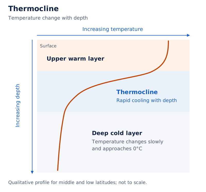
Temperature increases towards the right along the upper axis, while depth increases downwards. The curve bends sharply towards lower temperatures in the labelled thermocline and becomes much steeper on the page in the deeper cold water.
Drawn by One Young India. See Fig. 12.3 in your NCERT textbook
Depth and thickness are different measurements. A boundary's starting depth gives its position below the surface; its thickness describes its downward extent. Do not replace “usually around 100 to 400 m” with one fixed starting depth for every ocean.
What is salinity and why does it vary between regions?
Definition: Salinity is the total content of dissolved salts in seawater. It is calculated as grams of salt dissolved in 1,000 grams, or one kilogram, of seawater. The symbols g and kg mean grams and kilograms.
Salinity is usually expressed in parts per thousand, written ‰ or ppt. Both represent the same unit here. A salinity of 24.7‰ has been considered the upper limit for demarcating brackish water.
Which processes affect surface salinity?
Surface salinity depends mainly on evaporation and precipitation. Freshwater entering from rivers strongly influences coastal areas. Freezing and thawing of ice, its formation and melting, influence polar regions. Wind transfers water between areas, and currents contribute to salinity variations.
Salinity, temperature and density, mass per unit volume, are interrelated. Changes in temperature or density influence salinity in an area. Loss of water through evaporation or ice formation increases surface salinity, while freshwater input decreases it.
| Water body or setting | Salinity | Qualification |
|---|---|---|
| Normal open ocean | 33‰ to 37‰ | Usual range |
| Red Sea | As high as 41‰ | High salinity in an enclosed sea |
| Estuaries and the Arctic | 0‰ to 35‰ | Seasonal fluctuation |
| Hot, dry regions | Sometimes reaches 70‰ | High evaporation |
| Atlantic Ocean | Around 36‰ | Average salinity |
| Indian Ocean | 35‰ | Average salinity |
Estuaries are river-mouth waters where river water meets the sea. Very saline water bodies include Lake Van in Turkey at 330‰, the Dead Sea at 238‰ and the Great Salt Lake at 220‰. These values are not normal open-ocean salinities.
Case study: Why do the Bay of Bengal and Arabian Sea differ?
The Bay of Bengal shows a low-salinity trend because of river-water inflow. The Arabian Sea has higher salinity because evaporation is high and freshwater inflow is low. Both illustrate why a basin-wide average does not describe all its parts.
What contrasts occur in other seas?
The North Sea has higher salinity despite its higher latitude because the North Atlantic Drift brings more saline water. The Baltic Sea has low salinity because large quantities of river water enter it.
High evaporation produces higher salinity in the Mediterranean Sea. Enormous freshwater inflow from rivers makes salinity very low in the Black Sea. These contrasts connect regional salinity with water gains, water losses and transport by currents.
How do ocean salinity patterns change horizontally and vertically?
Horizontal salinity distribution means differences across ocean areas. In the Pacific Ocean, variation is mainly associated with its shape and large area. In its western northern parts, salinity decreases from 35‰ to 31‰ because melted water enters from the Arctic.
Beyond 15° to 20° south, Pacific salinity decreases to 33‰. Atlantic salinity gradually decreases towards the north. These patterns describe particular regions, so they should not be converted into one identical rule for all oceans.
What the figure shows
Surface salinity of the world's oceans
Numbered lines cross a world map, with values including 30, 32, 33, 34, 35, 36 and 37. The Atlantic contains enclosed lines labelled 37, while the northern Indian Ocean shows contrasting labelled values.
See Fig. 12.5 in your NCERT textbook
How does salinity vary downwards?
Vertical salinity distribution means changes with depth. Its pattern depends on the location of the sea. Surface water responds to evaporation, ice formation and freshwater additions, whereas salinity at depth is very much fixed.
There is a marked difference between surface and deep zones. Lower-salinity water rests above denser, higher-salinity water. Salinity generally increases with depth, with a distinct zone called the halocline where it increases sharply.
- Freshwater input lowers surface salinity, while loss of water through evaporation or ice formation raises it.
- Other factors being constant, increasing salinity increases the density of seawater.
- Higher-salinity seawater generally sinks beneath water with lower salinity.
- This arrangement produces stratification by salinity, meaning the organisation of water into layers related to salt content.
How do the halocline and thermocline differ?
A halocline concerns a sharp salinity increase with depth. A thermocline concerns a rapid temperature decrease with depth. Both describe vertical changes, but they refer to different properties of seawater.
Note: Retain “generally” when describing downward salinity increase and the sinking of saltier water. Retain “other factors being constant” when connecting increasing salinity to increasing density.
Glossary
- Hydrological cycle — Continuous circulation of water in liquid, solid and gaseous forms between oceans, atmosphere, land and organisms.
- Continental shelf — Extended continental margin occupied by relatively shallow seas and gulfs, with a very gentle average gradient.
- Shelf break — Very steep slope at which the continental shelf typically ends.
- Continental slope — Steep region connecting the continental shelf with the ocean basin, beginning where the shelf drops sharply.
- Deep sea plain — Gently sloping, extremely flat ocean-basin region covered by fine-grained sediments such as clay and silt.
- Oceanic trench — Relatively steep-sided, narrow basin forming one of the deepest parts of an ocean.
- Mid-oceanic ridge — Underwater mountain system consisting of two chains separated by a large depression.
- Seamount — Volcanic mountain with pointed summits rising from the seabed without reaching the ocean surface.
- Guyot — Flat-topped seamount showing evidence of gradual subsidence into a submerged mountain.
- Atoll — Low tropical ocean island consisting of coral reefs surrounding a central depression containing water.
- Thermocline — Boundary region between surface and deeper ocean water where temperature decreases rapidly with depth.
- Salinity — Total dissolved salt content of seawater, usually expressed as parts per thousand.
- Halocline — Distinct zone in ocean water where salinity increases sharply with increasing depth.
- Stratification by salinity — Layering in which lower-salinity water rests above denser water of higher salinity.
Common errors and misconceptions
- Misconception: Renewable water guarantees an adequate supply everywhere. Correct: Water distribution is uneven, demand is rising tremendously, and river pollution further aggravates water crises across places and times.
- Misconception: Every continental shelf is about 80 km wide. Correct: This is an average. Some shelves are almost absent or very narrow, while the Siberian shelf stretches to 1,500 km.
- Misconception: Trenches lie only 3 to 5 km below sea level. Correct: They are some 3 to 5 km deeper than the surrounding ocean floor.
- Misconception: Seamount and guyot mean exactly the same shape. Correct: A seamount has pointed summits; a guyot is a flat-topped seamount showing evidence of gradual subsidence.
- Misconception: The warmest ocean water is found exactly at the equator. Correct: The highest temperature is recorded slightly north of the equator.
- Misconception: Every latitude has the same three thermal layers. Correct: The three-layer structure describes middle and low latitudes. Arctic and Antarctic circles have one cold layer with very slight temperature change downwards.
- Misconception: Thermocline and halocline name the same change. Correct: A thermocline has a rapid temperature decrease; a halocline has a sharp salinity increase with depth.
- Misconception: Salinity must increase downwards in exactly the same way everywhere. Correct: Its vertical pattern depends on location. It generally increases with depth, and saltier water generally sinks below less saline water.
Exam-style questions with model answers
Q1. Salinity measures grams of dissolved salt in 1,000 g of seawater and is usually expressed in parts per thousand (‰ or ppt). The Indian Ocean has an average salinity of 35‰. State the corresponding salt content and explain the unit. [2 marks]
- An average salinity of 35‰ corresponds to 35 g of dissolved salts in 1,000 g of Indian Ocean seawater.
- The unit is parts per thousand, written ‰ or ppt. It expresses dissolved salt content relative to a thousand parts of seawater.
Q2. Compare shelves and slopes using these data: shelf gradient averages 1° or even less, depth may be 30 to 600 m, and it extends a continental margin beneath relatively shallow seas and gulfs; slope gradient is 2° to 5°, depth is 200 to 3,000 m, and it connects shelf with basin. Give three comparisons. [3 marks]
- Gradient: A continental shelf has a gentle average gradient of 1° or even less, whereas the continental slope has a steeper gradient of 2° to 5°.
- Depth: Shelf depth may be as shallow as 30 m or as deep as 600 m; slope depth varies between 200 and 3,000 m.
- Position: The shelf extends the continental margin beneath shallow water, while the slope connects that shelf with the ocean basin.
Q3. The average continental shelf width is about 80 km. Shelves along Chile and western Sumatra are almost absent or very narrow; the Siberian shelf reaches 1,500 km and is the world's largest. Use these facts to explain why average shelf width is not a universal width. [3 marks]
- The figure of about 80 km represents an average continental shelf width. It should not be treated as the width of every continental shelf.
- Chile and western Sumatra illustrate the narrow end of the variation: their shelves are almost absent or very narrow along these margins.
- The Siberian shelf illustrates the other extreme. It is the world's largest shelf and stretches to 1,500 km, showing how greatly shelf widths can differ.
Q4. Explain four temperature controls using these facts: insolation decreases poleward; northern oceans contact more land and receive more heat; offshore winds remove warm water and allow cold upwelling, while onshore winds pile warm water near coasts; warm currents raise temperatures in cold areas and cold currents lower them in warm ocean areas. [4 marks]
- Latitude: Decreasing insolation towards the poles reduces surface-water temperature, producing the broad pattern of warmer low latitudes and colder high latitudes.
- Land and water distribution: Northern oceans receive more heat because they are in contact with a larger extent of land than southern oceans.
- Winds: Offshore winds remove warm surface water and permit cold upwelling. Onshore winds accumulate warm water near the coast and raise its temperature.
- Currents: Warm currents raise temperatures in cold areas, while cold currents lower temperatures in warm ocean areas, modifying local ocean temperatures.
Q5. Describe thermal layering using these data: middle and low latitudes have a warm upper layer about 500 m thick at 20°C to 25°C, present year-round in the tropics but only in summer at middle latitudes; a thermocline 500 to 1,000 m thick with rapid downward cooling; and a very cold bottom layer extending to the deep ocean floor. About 90 per cent of water volume is below the thermocline, approaching 0°C. Arctic and Antarctic circles have one cold layer from surface to deep floor, near 0°C with very slight downward change. Give five points. [5 marks]
- At middle and low latitudes, the upper warm layer is about 500 m thick and has temperatures ranging between 20°C and 25°C.
- This upper layer persists throughout the year in the tropical region. At middle latitudes, it develops only during summer, giving the warm layer a seasonal presence.
- The thermocline lies below the first layer, is 500 to 1,000 m thick and is characterised by a rapid temperature decrease with increasing depth.
- The third layer is very cold and extends to the deep floor. About 90 per cent of water volume lies below the thermocline, where temperatures approach 0°C.
- In the Arctic and Antarctic circles, one cold layer extends from surface to floor. Surface temperatures are close to 0°C, with very slight change downwards.
Q6. Compare salinity causes in five settings using the information supplied: the Bay of Bengal receives river water and has a low-salinity trend; the Arabian Sea has high evaporation, low freshwater inflow and higher salinity; the North Atlantic Drift brings saline water to the North Sea; the Mediterranean has high evaporation and higher salinity; enormous river inflow makes Black Sea salinity very low. [5 marks]
- The Bay of Bengal shows a low-salinity trend because river-water inflow supplies freshwater. Its salinity pattern reflects the influence of freshwater additions to seawater.
- The Arabian Sea has higher salinity because evaporation is high and freshwater inflow is low. Its water-gain and water-loss conditions contrast with those of the Bay of Bengal.
- The North Sea receives more saline water carried by the North Atlantic Drift. Water transport by a current therefore accounts for its higher salinity.
- The Mediterranean Sea records higher salinity because evaporation is high. Loss of water through evaporation explains the supplied regional salinity pattern.
- The Black Sea has very low salinity because rivers bring enormous quantities of freshwater. River inflow provides the explanation for its contrasting condition.
Q7. Explain salinity stratification in four points using these facts: surface freshwater input decreases salinity, while evaporation or ice formation increases it; salinity generally increases downwards, sharply in the halocline; other factors being constant, saltier water is denser; saltier water generally sinks below less saline water. [4 marks]
- Surface salinity responds to water exchange: freshwater input lowers it, whereas evaporation or loss of water to ice raises it.
- Salinity generally increases with depth. The halocline is the distinct zone where the increase in salinity is sharp.
- Other factors being constant, an increase in seawater salinity increases its density. This condition must accompany the relationship.
- Saltier water generally sinks below less saline water, leaving lower-salinity water above denser water and producing stratification by salinity.
Key takeaways
- The hydrological cycle continuously exchanges water between oceans, atmosphere, land and organisms in liquid, solid and gaseous forms.
- Renewable water remains constant while demand rises tremendously; uneven availability and river pollution contribute to water crises.
- The four major ocean-floor divisions are continental shelves, continental slopes, deep sea plains and oceanic deeps or trenches.
- Shelves vary greatly in width and depth; trenches are some 3 to 5 km deeper than the surrounding ocean floor.
- Latitude, unequal land and water distribution, prevailing winds and ocean currents control ocean-water temperature.
- The thermocline marks rapid downward cooling; the three-layer thermal structure applies to middle and low latitudes.
- Salinity expresses dissolved salts per thousand parts of seawater and varies with evaporation, freshwater inputs, ice, winds and currents.
- Salinity generally increases with depth; other factors being constant, higher salinity increases density and contributes to layering.
Test yourself
What makes water a cyclic resource?
Water can be used and re-used as it circulates continuously between oceans, atmosphere, land and organisms in different physical forms.
What typically marks the outer end of a continental shelf?
The shelf typically ends at a very steep slope called the shelf break.
How can a guyot be distinguished from a pointed seamount?
A guyot is a flat-topped seamount, showing evidence of gradual subsidence into a submerged mountain.
What happens near a coast when winds drive warm surface water away?
Cold water rises from below through upwelling, changing the temperature conditions near the coast.
Where is the highest ocean temperature recorded relative to the equator?
The highest ocean temperature is recorded slightly north of the equator, rather than exactly at it.
What does the term thermocline describe?
It describes the boundary region where temperature decreases rapidly with increasing depth between surface and deeper ocean waters.
Why is the Bay of Bengal less saline in trend than the Arabian Sea?
The Bay of Bengal receives river water. The Arabian Sea has high evaporation and low freshwater inflow, giving it higher salinity.
What qualification belongs with the relationship between salinity and density?
Other factors being constant, increasing the salinity of seawater causes its density to increase.
Write about it
Turn a question from this chapter into a paper.
The Writing Studio has a structure guide, a rubric and citation tools for 15 formats, from essays to research papers. Drafting is free with an account. Learnacy Essential adds feedback from an AI writing coach and submission to The OYI Review.
Learnacy Essential is ₹1,499 for the year. Publication depends on review and is not guaranteed.