
An Imperial Capital: Vijayanagara | CBSE Class 12 History Notes
On this page

This note covers Vijayanagara’s political history, rulers and military chiefs, trade and social groups, water management, fortifications, royal ceremonies, sacred architecture, historical sources, archaeological surveys and the interpretation of the remains at Hampi.
What were the origins and historical setting of Vijayanagara?
A city and an empire
Vijayanagara, meaning “city of victory”, named both an imperial capital and an empire. Tradition and inscriptions associate its foundation in 1336 with the brothers Harihara and Bukka. Its boundaries changed, incorporating people who spoke different languages and followed different religious traditions.
At its greatest extent, the empire stretched from the river Krishna to the extreme south of the peninsula. Contemporaries referred to it as karnataka samrajyamu. The modern name Hampi derives from Pampadevi, a local mother goddess whose shrine helped preserve memories of the place.
Competition and cultural exchange
Vijayanagara developed alongside other powerful states. The Bahmani kingdom was established in 1347, while the Gajapati kingdom of Orissa emerged in 1435. The rayas competed with the Deccan Sultans and Gajapati rulers for fertile river valleys and the profits of overseas trade.
Political rivalry did not prevent the exchange of ideas. Rulers borrowed architectural concepts and construction techniques, adapting them to their own purposes. Vijayanagara also inherited traditions from areas previously ruled by the Cholas and Hoysalas, including elaborate temple patronage.
The Brihadishvara temple at Thanjavur and the Chennakeshava temple at Belur exemplified earlier royal support for monumental temples. The Vijayanagara rulers, who called themselves rayas, developed these traditions further through impressive gateways, halls and religious endowments.
Note: Tradition and epigraphic evidence associate Vijayanagara’s foundation with 1336, although the exact date remains uncertain.
Which sources reveal Vijayanagara’s history, and what are their limitations?
Discovery and documentation
Colin Mackenzie, an engineer and antiquarian employed by the English East India Company, brought the Hampi ruins to scholarly attention in 1800. He prepared the first survey map, drawing much initial information from priests of the Virupaksha temple and Pampadevi’s shrine.
Born in 1754, Mackenzie became the first Surveyor General of India in 1815 and held the post until his death in 1821. His interest in local histories also served colonial governance. His favourable portrayal of British rule must therefore be recognised as a perspective.
Epigraphists began collecting inscriptions at Hampi in 1836. Photography added another record from 1856, when Alexander Greenlaw took detailed photographs of the remains. In 1876, J.F. Fleet began documenting inscriptions on temple walls.
Combining different kinds of evidence
| Source | What it helps establish | Interpretive caution |
|---|---|---|
| Temple inscriptions | Donations by rulers and nayakas, and important events | They need to be read alongside other records |
| Travellers’ accounts | Markets, ceremonies, buildings and urban life | Descriptions reflect particular observers and their interests |
| Surviving buildings | Spatial organisation, materials and construction techniques | The function of a named structure may remain uncertain |
| Oral traditions and literature | Local memories and the cultural meanings of places | They should be compared with inscriptions and material evidence |
Fifteenth-century visitors included the Italian trader Nicolo de Conti, the Persian ambassador Abdur Razzaq and the Russian merchant Afanasii Nikitin. Portuguese observers Duarte Barbosa, Domingo Paes and Fernao Nuniz visited in the sixteenth century.
Literature in Telugu, Kannada, Tamil and Sanskrit supplements these accounts. Buildings reveal how spaces were constructed, but cannot by themselves establish ordinary people’s responses, workers’ wages or the organisation of building labour. Historical reconstruction depends on combining evidence while acknowledging unanswered questions.
How did dynastic changes and Krishnadeva Raya shape imperial power?
From Sangama to Tuluva rule
The Sangama dynasty controlled the empire until 1485. Military commanders of the Saluva dynasty then took power, ruling until 1503, when the Tuluvas replaced them. Competition for authority involved both members of ruling families and military commanders.
Krishnadeva Raya, a Tuluva ruler, reigned from 1509 to 1529. His reign combined territorial expansion with consolidation. Military preparedness continued even while the kingdom enjoyed exceptional peace and prosperity.
| Date | Development | Significance |
|---|---|---|
| 1512 | Acquisition of the Raichur doab | Control expanded over land between the Krishna and Tungabhadra |
| 1514 | Subjugation of the rulers of Orissa | The raya strengthened his position against a northern rival |
| 1520 | Severe defeats inflicted on the Sultan of Bijapur | Military success reinforced imperial power |
Patronage and the capital
Krishnadeva Raya built temples and added imposing gopurams to important south Indian shrines. He founded the suburban township of Nagalapuram near Vijayanagara, naming it after his mother. Some of the fullest descriptions of the capital belong to his reign or the years immediately following it.
His Telugu work on statecraft, the Amuktamalyada, explains the political importance of commerce. He encouraged better harbours, care for foreign sailors and favourable treatment of merchants supplying valuable animals and goods. Trade policy could help secure supplies that rival rulers also wanted.
Imperial strength therefore depended on more than conquest. The ruler sought to combine military resources, commercial prosperity and religious patronage. Temples and suburban development made his authority visible within the landscape, while trade helped sustain the resources on which the state depended.
Why did Vijayanagara decline, and what were the consequences of 1565?
Internal strain and shifting alliances
After Krishnadeva Raya’s death in 1529, his successors faced rebellious nayakas, or military chiefs. By 1542, control at the centre had passed to the Aravidu lineage. It remained in power until the end of the seventeenth century.
The military ambitions of Vijayanagara and the Deccan Sultanates produced changing alliances. Relations were not uniformly hostile. Krishnadeva Raya had supported claimants to power in the Sultanates and claimed the title “establisher of the Yavana kingdom”.
The Sultan of Bijapur also intervened in Vijayanagara succession disputes after Krishnadeva Raya’s death. Both sides could see advantages in the stability of neighbouring states. Religious differences alone cannot explain the pattern of cooperation, rivalry and eventual war.
Defeat and the movement of power
Rama Raya, Vijayanagara’s chief minister, attempted to play one Sultan against another. This policy encouraged the Sultanates to unite against him. In 1565, he led the army at Rakshasi-Tangadi, also known as Talikota.
The combined armies of Bijapur, Ahmadnagar and Golconda defeated his forces. The victorious armies sacked Vijayanagara, and the city was abandoned within a few years. The focus of imperial government shifted eastwards.
The Aravidus ruled first from Penukonda and later from Chandragiri, near Tirupati. During the seventeenth century, many nayakas established independent kingdoms, accelerating the collapse of central imperial authority. Nevertheless, they continued traditions of palace construction, fortification and temple building.
Note: The destruction of the capital in 1565 was not the immediate disappearance of every imperial institution or ruling lineage. Distinguish the city’s abandonment from the longer decline of central power and the survival of architectural traditions.
How did different social groups participate in the empire’s economy and government?
Rayas, nayakas and military authority
Nayakas usually controlled forts and maintained armed supporters. They often moved between regions and in many cases were accompanied by peasants seeking fertile land. They usually spoke Telugu or Kannada. Many submitted to the raya, but they often rebelled and had to be subdued by military action.
The amara-nayaka system linked territorial government, taxation and military service. Many features were probably derived from the Delhi Sultanate’s iqta system. Amara-nayakas were military commanders assigned territories by the ruler, with responsibilities supported by local revenue.
- The raya assigned a territory to an amara-nayaka for government.
- The commander collected taxes and other dues from peasants, craftspersons and traders.
- Part of this revenue supported the commander personally and maintained a stipulated contingent of horses and elephants.
- Some revenue maintained temples and irrigation works, while annual tribute and gifts acknowledged the raya’s authority.
Kings occasionally transferred commanders to assert control. Amara-nayakas personally attended court with gifts, expressing loyalty as well as meeting obligations. These arrangements supplied a powerful fighting force, but later independent nayaka kingdoms weakened the imperial centre.
Merchants and overseas traders
Effective cavalry required imported horses from Arabia and Central Asia. Arab traders initially controlled this trade, while local kudirai chettis, or horse merchants, also participated. Portuguese arrivals from 1498 introduced another trading and military presence on the west coast.
Portuguese military technology, particularly muskets, helped them become influential. Vijayanagara’s markets also traded spices, textiles and precious stones. Wealthy consumers wanted exotic luxury goods, while commercial revenue contributed to the prosperity of the state.
Peasants, craftspersons and ordinary residents
Peasants, artisans and traders supplied the taxes collected by commanders. Their lives are less fully represented by surviving monumental buildings. Barbosa described ordinary houses as thatched, well built and arranged in long streets according to occupations, with open spaces between them.
Fine Chinese porcelain suggests that some urban areas housed wealthy traders. The north-eastern urban core also included a Muslim residential quarter. Mosques and tombs had distinctive purposes but architectural similarities to temple mandapas, revealing interaction across religious communities.
How did the landscape and waterworks sustain the capital?
The natural basin
Vijayanagara occupied a basin formed by the Tungabhadra, which flows north-eastwards. Granite hills surrounded the city, while streams descended from rocky outcrops towards the river. The terrain shaped both the layout of settlements and the management of water.
The region is among the most arid parts of the peninsula. Water had to be stored and conveyed through elaborate arrangements. Embankments across streams created reservoirs of different sizes, collecting water for agriculture and the requirements of the city.
What the figure shows
Plan of Vijayanagara
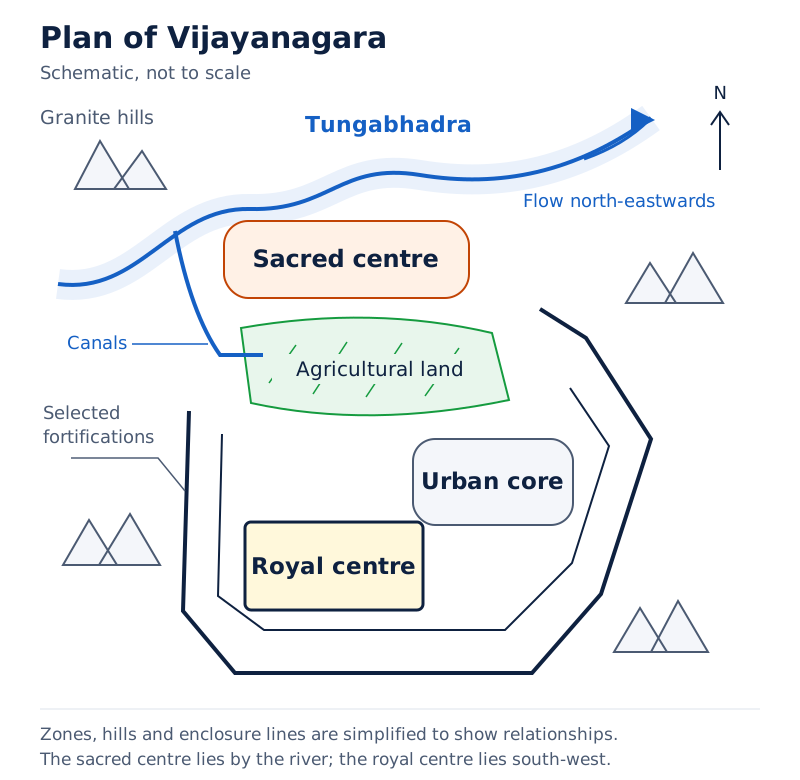
The plan marks the sacred centre beside the river, the urban core and the royal centre farther south. Hills, watercourses and enclosure lines appear together, showing how the city occupied an uneven landscape.
Drawn by One Young India. See Fig. 7.4 in your NCERT textbook
Tanks, channels and irrigation
| Waterwork | Supply or location | Use |
|---|---|---|
| Kamalapuram tank | Built in the early fifteenth century | Irrigated nearby fields and supplied the royal centre through a channel |
| Hiriya canal | Drew water from a dam across the Tungabhadra | Irrigated the valley between the sacred centre and urban core |
| Wells and local tanks | Distributed through inhabited areas | May have supplied ordinary town dwellers |
The Hiriya canal was apparently constructed under the Sangama kings. Its irrigated valley formed part of the agricultural landscape within the city’s wider defences. Water infrastructure supported cultivation as well as buildings and gardens.
Paes described a tank constructed by Krishnadeva Raya at the mouth of two hills. Water collected from the surrounding slopes and arrived through pipes from another lake. His account also describes irrigation of gardens and rice fields and the large labour force working on the tank.
These arrangements connected environmental conditions with royal investment. Reservoirs stored water, dams intercepted river flow and channels conveyed supplies to particular areas. A city containing fields, gardens, temples and residential districts required a network of waterworks, rather than one isolated source.
Why did fortifications protect agricultural land as well as buildings?
Defence against prolonged sieges
Abdur Razzaq described seven lines of forts surrounding Vijayanagara, its agricultural hinterland and forests. The outermost wall connected surrounding hills. Cultivated fields, gardens and houses lay between the first lines of fortification, rather than entirely outside the defended area.
This arrangement responded to the danger of sieges. Besieging armies often attempted to starve defenders into surrender. A siege could continue for months or years. Whereas rulers commonly stored grain in fortified granaries, Vijayanagara also protected the agricultural belt itself.
Modern archaeological evidence supports travellers’ descriptions of cultivated tracts. The area between the sacred centre and urban core contained agricultural land served by canals drawing water from the Tungabhadra. Food production and water management were therefore part of the city’s defensive organisation.
Walls, gates and roads
The massive outer masonry walls tapered slightly. Wedge-shaped stone blocks held together without mortar or another cementing material; the inner portions of the walls contained earth packed with rubble. Square or rectangular bastions projected outwards.
Additional fortifications enclosed the urban core and royal centre. Within the latter, major groups of buildings had their own high walls. Well-guarded gates regulated entry and connected the enclosures to important roads.
Arches and domes on gateways reveal Indo-Islamic architectural influences. This style developed through interaction between techniques introduced by Turkish Sultans and local building practices. Its use at Vijayanagara is evidence of architectural exchange across political boundaries.
Archaeologists trace roads through gateways and surviving pavements. Routes generally followed valleys, avoiding rocky terrain. Some major roads began at temple gateways and were lined with bazaars, linking religious spaces with commercial activity and movement through the city.
How did the royal centre compare with the sacred centre?
Distinct zones with overlapping functions
The royal centre occupied the south-western settlement, while the sacred centre lay towards the rocky northern riverbank. These names identify major concentrations of buildings, but do not imply a complete separation between political and religious activities.
More than 60 temples stood within the royal centre. Their presence demonstrates the importance of temple patronage in establishing royal legitimacy. About thirty building complexes have been identified as palaces because of their size and apparent lack of ritual functions.
| Feature | Royal centre | Sacred centre |
|---|---|---|
| Position | South-western part of the settlement | Northern riverbank among rocky hills |
| Prominent structures | Palace complexes, platforms and temples | Major temple complexes and shrines |
| Religious associations | Royal patronage of temples and cults | Virupaksha, Pampadevi and other sacred traditions |
| Political importance | Displays of authority and royal ceremonies | Royal claims to divine support and public temple patronage |
Buildings whose functions need qualification
Temples were built entirely of masonry, whereas secular buildings had superstructures of perishable materials. This difference helps explain the uneven survival of buildings. Surviving foundations or platforms do not always reveal the complete form or purpose of the original structure.
The “king’s palace” is the largest enclosure, but firm evidence that it was a royal residence has not been found. The so-called audience hall had closely spaced wooden pillars supporting an upper floor. Their spacing leaves its exact use uncertain.
The Lotus Mahal received its name from nineteenth-century British travellers. A map by Mackenzie suggested that it might have served as a council chamber. Its function remains uncertain. The Hazara Rama temple was probably meant to be used only by the king and his family; its surviving inner wall panels depict the Ramayana.
What was the significance of the mahanavami dibba and royal ceremonies?
A monumental platform
The mahanavami dibba stands on one of the city’s highest points. Its base covers about 11,000 square feet, and the platform rises to about 40 feet. Evidence indicates that it once supported a wooden structure. Relief carvings decorate its base.
Photographs: The mahanavami dibba; Carvings on the mahanavami dibba (NCERT Class 12 Figures 7.11 and 7.12). The photograph shows a raised stone platform with stepped upper levels. The close view of its reliefs shows horizontal bands of human and animal figures, including horses and elephants.
Rituals associated with this structure probably coincided with Mahanavami, the great ninth day of the autumn festival. The festival is known in different regions as Dusehra, Durga Puja or Navaratri. It provided an occasion for the ruler to display prestige, power and suzerainty.
Rituals and political relationships
Ceremonies included worship of the image and state horse, together with animal sacrifices. Dances, wrestling and processions of decorated horses, elephants, chariots and soldiers formed part of the celebrations. Chief nayakas and subordinate kings made ritual presentations before the ruler and his guests.
On the final day, the king inspected his own army and those of the nayakas in an open field. Nayakas presented rich gifts and the required tribute. These acts publicly expressed the relationship between the ruler and subordinate military authorities.
The political significance of the festival is clearer than the precise location of every activity. The space around the surviving platform appears insufficient for all the elaborate processions of people and animals described. It is therefore uncertain whether the dibba was the centre of the entire ritual.
Note: Explain what the ceremonies expressed, but retain “probably” when linking all Mahanavami rituals to this platform. The scale of the ceremonies creates a genuine problem of interpretation.
How did temple architecture connect sacred traditions with imperial authority?
Older traditions and royal legitimacy
The northern hills were associated with Vali and Sugriva’s kingdom in the Ramayana. Local tradition also linked them to Pampadevi’s penance to marry Virupaksha, a form of Shiva. Pre-Vijayanagara Jaina temples demonstrate that the area already held several sacred associations.
The rulers claimed to govern on behalf of Virupaksha. Royal orders were signed “Shri Virupaksha”, usually in Kannada script. The title “Hindu Suratrana” adapted the Arabic term Sultan into Sanskrit, meaning Hindu Sultan.
Temple construction associated rulers with divine authority and helped secure recognition of their power, wealth and piety. Temples also served as centres of learning and received land and other resources. Their religious role was intertwined with social, cultural and economic activity.
Gateways, halls and ceremonial spaces
Huge raya gopurams, or royal gateways, frequently dwarfed central shrine towers. Visible from a great distance, they signalled the presence of the temple and were probably meant as reminders of the kings’ power to command the resources, techniques and skills needed to build them. Mandapas and long pillared corridors provided spaces for activities beyond worship in the central shrine.
The Virupaksha temple developed over centuries; inscriptions suggest that its earliest shrine dated to the ninth-tenth centuries. Krishnadeva Raya added the hall before the main shrine to mark his accession and is credited with the eastern gopuram.
What the figure shows
Virupaksha temple plan
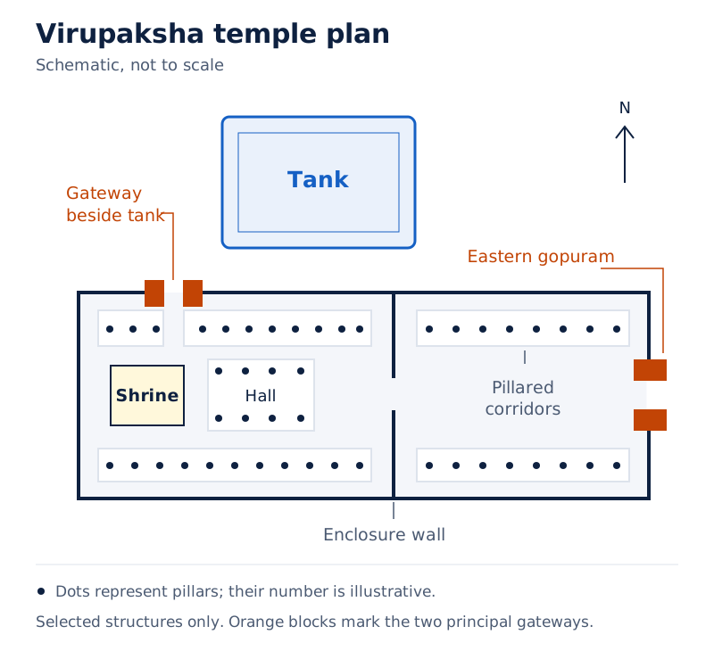
The plan labels a tank and shrine, shades two principal gateways black and marks rows of pillars with dots. Enclosures and pillared spaces surround the route through the complex.
Drawn by One Young India. See Fig. 7.21 in your NCERT textbook
Different halls accommodated music, dance and drama, divine weddings and swinging ceremonies. Special images used on these occasions differed from those kept in the central shrine. Royal portraits in temples and state visits accompanied by nayakas further connected kingship with worship.
Vitthala and commercial streets
The Vitthala temple honoured a form of Vishnu generally worshipped in Maharashtra. Its presence in Karnataka shows how imperial culture drew on different traditions. The complex included several halls and a distinctive chariot-shaped shrine.
Photograph: The chariot of the Vitthala temple (NCERT Class 12 Figure 7.24). The carved stone structure has prominent circular wheels below an ornate shrine with pillars. Its chariot form is visible in the photograph; the image does not establish that the structure moved.
Straight chariot streets extended from temple gopurams. Stone paving and pillared pavilions lined these streets, where merchants established shops. Nayakas continued temple construction and built impressive gateways, carrying forward the architectural traditions of the imperial capital.
How have archaeological surveys reconstructed the city and its everyday life?
Recording remains systematically
Conservation began under John Marshall in 1902. Through the twentieth century, the Archaeological Survey of India and the Karnataka Department of Archaeology and Museums preserved the site. In 1976, Hampi was recognised as a site of national importance.
A major documentation project began in the early 1980s. Scholars worked for nearly twenty years to record the remains using extensive and intensive surveys. Hampi became a UNESCO World Heritage site in 1986.
- Surveyors divided the area into twenty-five squares, each identified by an alphabetical letter.
- They subdivided each square into smaller squares to record locations more precisely.
- Further subdivisions allowed detailed recording of individual areas and structures.
- They documented shrines, residences, temples, roads, paths and bazaars, including traces such as pillar bases and platforms.
Material remains and living activities
Stone remains must be interpreted alongside the wooden elements that have disappeared. Columns, brackets, beams, ceilings, eaves and towers could once have completed structures whose stone portions survive. Travellers’ accounts help reconstruct activities that the ruined buildings alone cannot reveal.
Paes described merchants selling jewels and cloth, as well as an evening market with horses, fruit, vegetables and wood. He also described plentiful grain and pulses. Nuniz reported abundant fruit and meat, showing that markets supplied everyday provisions as well as luxury goods.
Surveys found numerous small shrines and temples, indicating varied cults, perhaps supported by different communities. Wells and rainwater and temple tanks may have supplied residents. Such evidence broadens the picture beyond the king’s court and major monuments.
Important questions nevertheless remain. Buildings cannot establish how ordinary women, men and children understood royal symbolism or whether they entered particular enclosures. Nor do they alone reveal builders’ origins, wages, supervisors or methods of transporting materials. These require further evidence.
What timeline connects political change with the rediscovery of Hampi?
Empire, capital and conservation
The timeline connects changes in rule with the later study of the abandoned capital. Political history explains the rise of ruling lineages and the crisis of the city. Documentation history explains how maps, photographs, inscriptions and conservation made its remains available for historical investigation.
| Date | Event |
|---|---|
| 1336, conventionally | Harihara and Bukka associated with the foundation of Vijayanagara; the date carries uncertainty |
| 1485 | Saluva commanders replace the Sangama dynasty |
| 1498 | Portuguese traders arrive on the subcontinent’s west coast |
| 1503 | Tuluva dynasty replaces the Saluvas |
| 1509 | Krishnadeva Raya’s reign begins |
| 1510 | Portuguese conquest of Goa |
| 1512 | Raichur doab acquired during Krishnadeva Raya’s reign |
| 1514 | Rulers of Orissa subdued |
| 1520 | Severe defeats inflicted on the Sultan of Bijapur |
| 1529 | Death of Krishnadeva Raya |
| 1542 | Control at the centre has shifted to the Aravidu lineage |
| 1565 | Defeat at Rakshasi-Tangadi and sack of Vijayanagara |
| 1800 | Mackenzie surveys the ruins at Hampi |
| 1836 | Epigraphists begin collecting inscriptions at Hampi |
| 1856 | Alexander Greenlaw takes detailed photographs of the remains |
| 1876 | J.F. Fleet begins documenting temple-wall inscriptions |
| 1902 | Conservation begins under John Marshall |
| 1976 | Hampi recognised as a site of national importance |
| Early 1980s | Extensive project to document the material remains begins |
| 1986 | Hampi declared a UNESCO World Heritage site |
Keep the stages distinct. The city’s destruction did not erase local memories, nor did modern scholarship begin with a complete account of its history. Oral information, inscriptions, travellers’ descriptions and material surveys gradually made reconstruction possible, while leaving some questions unresolved.
Glossary
- Vijayanagara — “City of victory”, the name used for both the imperial capital and the empire.
- Raya — The title used by Vijayanagara’s rulers, who supported military expansion and temple patronage.
- Nayaka — A military chief who usually controlled forts and maintained armed supporters within the empire.
- Amara-nayaka — A military commander assigned territory by the raya, collecting revenue and maintaining stipulated military contingents.
- Kudirai chettis — Local horse merchants who participated in the trade supplying horses for military use.
- Gajapati — Literally lord of elephants, the designation of a powerful fifteenth-century ruling lineage in Orissa.
- Gopuram — A temple gateway, often monumental in scale under Vijayanagara rulers and their successors.
- Mandapa — A pavilion or hall within temple architecture, accommodating religious and ceremonial activities.
- Mahanavami — Literally the great ninth day, associated with the autumn festival and displays of royal power.
- Hindu Suratrana — A royal title meaning Hindu Sultan, formed by Sanskritising the Arabic term Sultan.
- Elevation — A vertical view of a structure, showing architectural features from the side.
- Plan — A horizontal view of a structure, showing the arrangement of its spaces.
Common errors and misconceptions
- Misconception: Vijayanagara refers only to a city. Correct: It names both the capital and the empire, whose boundaries changed over time.
- Misconception: All relations with the Deccan Sultanates were hostile. Correct: Rivalry coexisted with alliances, intervention in succession disputes and architectural exchange.
- Misconception: The empire disappeared completely in 1565. Correct: The capital was sacked and abandoned, but Aravidu rule continued from other centres.
- Misconception: Fortifications surrounded only buildings. Correct: They also enclosed agricultural land, gardens and forests, helping protect food supplies during sieges.
- Misconception: The royal centre contained no religious buildings. Correct: More than sixty temples stood there, connecting royal authority with religious patronage.
- Misconception: Names such as “king’s palace” prove a structure’s original use. Correct: Several names are conventional, and the functions of some buildings remain uncertain.
- Misconception: Surviving monuments reveal exactly what ordinary people thought. Correct: Buildings reveal material arrangements, but responses, access and labour conditions require other evidence.
Exam-style questions with model answers
Q1. Evidence: Kamalapuram tank irrigated nearby fields and sent water through a channel to the royal centre. Identify its two functions. [2 marks]
- It supplied irrigation water to fields near the tank, supporting cultivation.
- It also provided water to the royal centre through a channel, linking storage with the needs of that part of the city.
Q2. Evidence: amara-nayakas received territories from the raya, collected dues from peasants, craftspersons and traders, maintained horses and elephants from part of the revenue, and sent annual tribute and gifts to court. Explain three links between revenue and authority. [3 marks]
- Territorial assignment gave the commanders a local revenue base. They collected dues from several productive groups, connecting government with the resources of the territory.
- Revenue maintained stipulated military contingents of horses and elephants. Local collections therefore supported the ruler’s fighting strength.
- Annual tribute and personal presentation of gifts acknowledged the raya’s authority. Commanders exercised local powers while expressing loyalty to the ruler who assigned their territories.
Q3. Evidence: sieges could last months or years and aimed to starve defenders; Vijayanagara enclosed fields within its walls; canals from the Tungabhadra irrigated land between the sacred centre and urban core. Explain the relationship between defence, agriculture and water. [4 marks]
- Long sieges threatened the supply of food. Protecting agricultural land addressed the danger that defenders could be starved into surrender.
- Fields within the fortifications brought cultivation inside the defended space. The walls therefore protected more than palaces, temples and houses.
- Canals drawing from the Tungabhadra sustained irrigation in the cultivated tract. Water management supported the agricultural system incorporated into the defences.
- Compared with storing grain in fortified granaries, protecting the agricultural belt itself was a more expensive and elaborate strategy for preparing against a siege.
Q4. Evidence: Krishnadeva Raya supported claimants in the Sultanates; Bijapur’s Sultan intervened in Vijayanagara succession disputes; Rama Raya played Sultans against one another; Bijapur, Ahmadnagar and Golconda defeated him at Rakshasi-Tangadi in 1565. Assess the claim that religious differences made war inevitable. [4 marks]
- The evidence does not support inevitability. Krishnadeva Raya’s support for claimants in the Sultanates demonstrates cooperation across religious differences.
- Bijapur’s intervention in Vijayanagara’s succession disputes likewise shows that rulers participated in each other’s political affairs.
- Rama Raya’s policy of playing Sultans against one another helps explain their eventual combination against him.
- The alliance of Bijapur, Ahmadnagar and Golconda and the defeat in 1565 arose within shifting political relationships. Religion alone cannot explain this pattern of cooperation and conflict.
Q5. Evidence: the royal centre contained over sixty temples and about thirty complexes identified as palaces; secular superstructures used perishable materials; the “king’s palace” lacks definite evidence of royal residence; closely spaced pillars make the audience hall’s function uncertain; Mackenzie’s map suggested the Lotus Mahal might be a council chamber. Explain why architectural labels require caution. [5 marks]
- The name “royal centre” should not suggest an exclusively secular zone. Its numerous temples show the presence of religious buildings alongside complexes identified as palaces.
- Perishable superstructures have disappeared from secular buildings. Surviving remains therefore provide an incomplete picture of their original appearance and use.
- The “king’s palace” lacks definitive evidence of royal residence. A familiar label is therefore not sufficient proof of function.
- The audience hall’s closely spaced pillars would have left little free space for an assembly, making its supposed function uncertain.
- The suggested council-chamber function of the Lotus Mahal remains a possibility. Architectural interpretations should distinguish observed evidence, conventional names and tentative explanations.
Q6. Evidence: Mahanavami celebrations included worship, animal sacrifices, dances, wrestling, decorated processions and presentations by subordinate rulers. On the last day the king inspected armies in an open field, and nayakas presented gifts and tribute. Space near the surviving dibba seems inadequate for all the processions. Explain the festival’s political significance and one limitation of reconstructing its setting. [5 marks]
- Worship and sacrifice placed royal participation within a ceremonial setting, linking the ruler’s public position with religious observance.
- Dances, wrestling and decorated processions made the celebrations an impressive display of prestige and power before participants and guests.
- Presentations by subordinate rulers expressed relationships of authority. Nayakas’ gifts and tribute publicly acknowledged obligations to the king.
- The inspection of the king’s and nayakas’ armies displayed military resources and brought different armed contingents together in a royal ceremony.
- The inadequate space around the surviving dibba limits certainty about its role. The festival’s political meaning can be explained without assuming every procession occurred beside that platform.
Q7. Evidence: Mackenzie’s 1800 survey used priests’ memories; inscriptions record donations and events; photographs document monuments; travellers describe markets and ceremonies; detailed surveys locate roads and bazaars through pavements, pillar bases and platforms. Buildings alone do not reveal ordinary people’s responses or builders’ wages. Explain how these sources complement one another and identify their limits. [6 marks]
- Priests’ memories supplied local information that helped Mackenzie begin surveying the site. Oral knowledge contributed to identifying and understanding the remains.
- Inscriptions provide records of donations and events, supplementing the spatial information available from maps and buildings.
- Photographs preserve visual records of monuments, allowing scholars to study their architectural details alongside written descriptions.
- Detailed surveys locate structures and trace roads or bazaars through surviving pavements, pillar bases and platforms, adding spatial evidence to written accounts.
- Travellers describe markets and ceremonies, helping reconnect material spaces with activities that took place within them.
- Limits remain: buildings alone cannot establish ordinary people’s reactions or builders’ wages. Further evidence is needed rather than unsupported conclusions.
Key takeaways
- Vijayanagara was both a city and an empire, conventionally founded in 1336 by Harihara and Bukka.
- Krishnadeva Raya combined expansion, military preparedness, trade policy and temple patronage during his reign from 1509 to 1529.
- Amara-nayakas connected territorial revenue with military service, while tribute and gifts expressed their relationship with the raya.
- Waterworks, irrigated agriculture and fortifications formed connected systems supporting urban life and resistance to prolonged sieges.
- Religious and political activities overlapped: temples stood within the royal centre and royal patronage shaped sacred architecture.
- The defeat of 1565 devastated the capital, while Aravidu rule and nayaka building traditions continued elsewhere.
- Maps, inscriptions, photographs, travellers’ accounts and local traditions together help reconstruct the city and its activities.
- Conventional building names and surviving stone remains must be interpreted cautiously, especially when original functions or ordinary lives remain uncertain.
Test yourself
Which four dynastic lineages successively controlled Vijayanagara?
The sequence was Sangama, Saluva, Tuluva and Aravidu, reflecting shifts between ruling families and military claimants.
Why were horse merchants important to the rulers?
Warfare depended on effective cavalry, making imported horses from Arabia and Central Asia valuable military resources.
What did the Hiriya canal irrigate?
It supplied the cultivated valley between the sacred centre and urban core, drawing water from a Tungabhadra dam.
Why is the royal centre not an exclusively secular zone?
It included over sixty temples, demonstrating the close relationship between royal legitimacy and religious patronage.
What did the nayakas present during the final festival ceremony?
They presented rich gifts and stipulated tribute to the king, publicly acknowledging their obligations and loyalty.
How did the Vitthala temple draw on different traditions?
Its principal deity was a form of Vishnu generally worshipped in Maharashtra, incorporated into a temple in Karnataka.
Why are travellers’ accounts useful when studying ruined buildings?
They describe activities and vanished features, helping connect surviving stone structures with the life of the city.
What remains uncertain about the Lotus Mahal?
Its original function remains uncertain, although Mackenzie’s map suggested it may have served as a council chamber.