
Bricks, Beads and Bones | CBSE Class 12 History Notes
On this page

Harappan origins and chronology, food and farming, urban planning, social differences, craft production, trade, seals and writing, authority and religion, the decline of cities, archaeological discoveries, and the interpretation of material evidence.
What were the origins and geographical setting of the Harappan civilisation?
The Harappan civilisation, also called the Indus Valley Civilisation, takes its name from Harappa, the site where it was first identified. Its history includes a formative phase, a flourishing urban phase and a later phase of decline and transformation.
How did early settlements develop into cities?
Early farming communities existed in the region around 7000 BCE. Before the Mature Harappan phase, settlements generally remained small. Their inhabitants practised agriculture and pastoralism, produced distinctive pottery and undertook crafts, but built virtually no large buildings.
The urban phase developed through gradual transformation within these earlier communities. Mature Harappan settlements occupied some areas used by earlier cultures and continued certain subsistence practices. Urban growth therefore involved both continuity and change.
| Phase | Approximate period | Main character |
|---|---|---|
| Early Harappan | 6000 BCE to 2600 BCE | Formative development before the major urban phase. |
| Mature Harappan | 2600 BCE to 1900 BCE | The prosperous urban phase, associated with distinctive cities and artefacts. |
| Late Harappan | 1900 BCE to 1300 BCE | Decline of urban features and development of successor cultures. |
How extensive was the settlement network?
Harappan objects occur across a wide region, including Afghanistan, parts of present-day Pakistan and several Indian states. Rakhigarhi, Mohenjodaro, Harappa, Dholavira and Ganweriwala are identified as five major cities. Other settlements included agricultural villages, regional centres, ports and manufacturing centres.
Recognisable pottery, bricks, beads, seals, weights and copper or bronze objects help archaeologists identify this shared material culture. Their distribution connects settlements that differed considerably in size and function.
What the figure shows
Important Mature Harappan sites
The map labels Harappa and Mohenjodaro along the Indus river system, Rakhigarhi and Kalibangan farther east, and Dholavira, Lothal and Nageshwar towards the Arabian Sea. Rivers and settlements appear together; the sketch is not to scale.
Reference: NCERT Class 12 Map 1
How do food remains and farming evidence reveal subsistence strategies?
Subsistence strategies are the ways people obtained food. Charred grains and seeds reveal plant foods, while animal bones help reconstruct the use of domesticated and wild species. Different specialists study these remains, allowing several kinds of evidence to be compared.
What did people eat?
| Evidence | Examples | Interpretation |
|---|---|---|
| Charred grains and seeds | Wheat, barley, lentil, chickpea and sesame. | Archaeo-botanists identify plant foods. |
| Regional crop finds | Millets at Gujarat sites; relatively rare rice finds. | Crop remains were not equally common everywhere. |
| Domesticated animal bones | Cattle, sheep, goat, buffalo and pig. | Zoo-archaeological study indicates animal domestication. |
| Wild animal bones | Boar, deer and gharial. | People used wild animal products, but the suppliers remain uncertain. |
| Other animal remains | Fish and fowl bones. | Diet included these animal foods as well. |
Wild bones do not establish who hunted the animals. Harappans may have hunted them themselves or obtained meat from hunting communities. Evidence for consumption must be distinguished from evidence for the organisation of food supply.
What can be inferred about agricultural technology?
Terracotta plough models occur in Cholistan and Banawali. At Kalibangan, an Early Harappan ploughed field had two sets of furrows crossing at right angles. This suggests that two different crops were grown together.
Bull representations suggest familiarity with the animal; archaeologists infer the use of oxen for ploughing. Grain finds establish agriculture more securely than they establish precise sowing or harvesting methods. The choice between stone blades in wooden handles and metal harvesting tools remains uncertain.
Most sites lay in semi-arid areas, where irrigation was probably needed. Canal traces occur at Shortughai, but have not been identified in Punjab or Sind. Earlier canals may have silted up. Wells probably supplied water, and Dholavira's reservoirs may have stored agricultural water.
Food processing required querns and vessels for grinding, mixing and cooking. These objects were made from materials including stone, metal and terracotta. Their form and wear help suggest how people prepared food.
How did Mohenjodaro's streets, houses and drains demonstrate planning?
Mohenjodaro was divided into a smaller, higher Citadel and a larger, lower town. Buildings on mud-brick platforms gave the Citadel its height. Walls separated it physically from the Lower Town, which was also walled.
What had to be planned before houses were built?
Platforms provided foundations and fixed the space available for later construction. Their preparation required labour on a large scale. Streets followed an approximate grid, intersecting at right angles. Drains appear to have been laid out before houses were built alongside them.
Bricks also indicate coordination. Whether baked or sun-dried, their length and breadth were respectively four and two times their height: a 4:2:1 ratio. This standardisation extended across Harappan settlements rather than being confined to one building.
How were houses arranged?
Many houses in the Lower Town had rooms around a courtyard, probably used for cooking and weaving. Ground-level walls lacked windows, and entrances avoided a direct view into the interior or courtyard. These arrangements suggest concern for privacy.
Houses had brick-paved bathrooms connected to street drains. Some retained staircases leading to an upper storey or roof. Many had wells, often in a room accessible from outside. The estimated total number of wells at Mohenjodaro was about 700.
What the figure shows
A large Mohenjodaro house
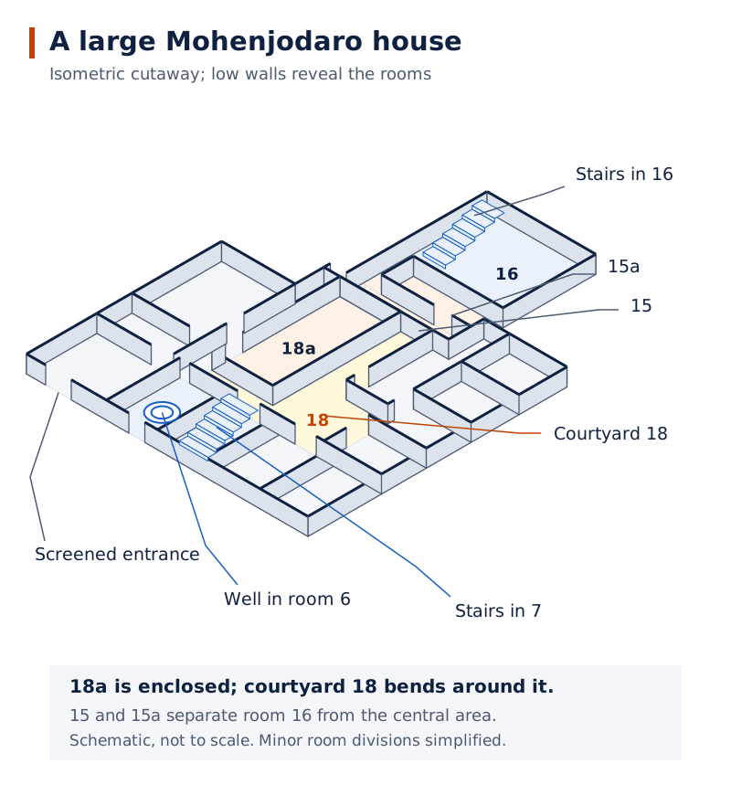
The isometric drawing shows numbered rooms, internal open spaces, staircases and enclosing walls. A circular well is visible in room 6. The drawing makes the relationship between rooms and circulation spaces easier to follow.
Drawn by One Young India. See Fig. 1.9 in your NCERT textbook
How did drainage work?
- Water left the bathroom through a house drain connected through the wall.
- The house drain emptied into a sump or cesspit, where solid material settled.
- Waste water continued into the street drain, whose main channels used bricks set in mortar.
- Loose covers could be removed for cleaning; long channels had additional sumps at intervals.
Drainage was also present in smaller settlements. At Lothal, houses used mud bricks while drains used burnt bricks. Planning therefore extended beyond monumental buildings and included the routine management of domestic waste water.
What distinguished the Citadel's public buildings from ordinary houses?
The Citadel contained structures probably used for special public purposes. Two prominent examples are the warehouse and the Great Bath. Their scale and setting distinguish them from the domestic buildings of the Lower Town.
What survives of the warehouse and Great Bath?
The warehouse retains its lower brick portions. Its upper portions were probably wooden and decayed. This illustrates how surviving buildings provide an incomplete picture: materials differ in how well they endure.
The Great Bath was a rectangular tank within a courtyard, with corridors on all four sides. Steps on the north and south led into the tank. Bricks laid on edge and gypsum mortar helped make it watertight.
Rooms surrounded three sides, and one contained a large well. Water drained from the tank into a large drain. Across a lane to the north stood a smaller building containing eight bathrooms, arranged four on each side of a corridor.
What the figure shows
Plan of the Citadel
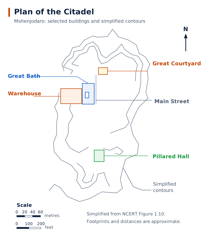
The plan labels the Great Bath, Warehouse, Great Courtyard and Pillared Hall among other features. A north arrow and scales accompany the plan, while contour lines surround the excavated areas.
Drawn by One Young India. See Fig. 1.10 in your NCERT textbook
How certain is the proposed ritual function?
The tank's unusual form and its location among distinctive buildings suggest a special ritual bath. This remains an interpretation, rather than proof of a particular ceremony or deity. Its engineering is clearer than the precise beliefs associated with its use.
Settlement layouts also varied. Dholavira and Lothal were fortified as whole settlements, with internal divisions. Lothal's Citadel stood at a height but was not separately walled. One city's arrangement should not be imposed on every Harappan site.
How can different social groups and inequalities be studied?
Archaeologists examine burials and the distribution of objects to investigate social differences. Neither approach reveals a complete social hierarchy. A grave, a workshop and a wealthy household preserve different kinds of evidence about people's lives.
What do burials reveal about men and women?
The dead were generally placed in pits, sometimes lined with bricks. Some graves contained pottery or ornaments, possibly intended for an afterlife. Jewellery occurs with both men and women, so its presence alone does not identify a burial as female.
A male burial excavated at Harappa in the mid-1980s contained shell rings, a jasper bead and numerous micro beads near the skull. Copper mirrors occur in some burials. On the whole, it appears that Harappans did not believe in burying precious things with the dead.
How do users of ordinary and valuable objects compare?
Utilitarian objects, such as querns, pottery, needles and body scrubbers, were generally made relatively easily from ordinary materials and occur widely. Objects classified as luxuries were rare, technically demanding or made from costly, non-local materials.
Faience pots were difficult to manufacture. Miniature examples, perhaps perfume containers, occur mainly at Mohenjodaro and Harappa, rather than at Kalibangan. All gold jewellery found at Harappan sites was recovered from hoards. Concentrations of valuable objects suggest differences in access to resources.
What is known about craft workers and gender?
Workshop remains reveal specialised production, but they do not automatically identify the workers' gender. Questions about whether women made pottery or painted it remain open. Occupational activity is often easier to recognise than the identities or status of those performing it.
Note: Utilitarian and luxury are not completely separate categories. A spindle whorl made from rare faience could serve an everyday function while also requiring valuable material and specialised skill.
How were beads and other crafts produced and identified?
Chanhudaro, covering less than seven hectares compared with Mohenjodaro's 125 hectares, was almost entirely devoted to crafts. Activities included bead-making, shell-cutting, metal-working, seal-making and weight-making. Crafts also took place in the larger cities.
Which materials and techniques did bead-makers use?
Beads were made from carnelian, jasper, crystal, quartz and steatite; copper, bronze and gold; and shell, faience and terracotta. Some combined stones cemented together, while others had gold caps. Shapes included discs, cylinders, spheres, barrels and segmented forms.
Steatite is soft and easy to work. Paste made from its powder could be moulded into varied shapes, unlike the more geometrical forms produced from harder stones. The manufacture of tiny steatite micro beads remains a technological puzzle.
- For carnelian beads, nodules were chipped into rough shapes.
- Fine flaking brought each piece closer to its final form.
- Grinding and polishing refined the surface.
- Drilling completed the bead; firing the yellowish material and beads at different production stages developed the red colour.
Experimental study helps reconstruct these methods. Specialised drills occur at Chanhudaro, Lothal and Dholavira. Decoration could involve incising, painting or etching designs, depending on the object and technique.
What distinguishes a workshop from a place using finished goods?
Production centres contain raw materials, tools, unfinished objects, rejects and waste. Small shell or stone fragments are particularly useful: larger offcuts might be reused, but tiny pieces often remained where the cutting took place.
Nageshwar and Balakot were specialised shell-working centres near the coast. Their bangles, ladles and inlay pieces went to other settlements. Finished beads from Chanhudaro and Lothal probably travelled to major centres such as Mohenjodaro and Harappa.
A finished bead alone could indicate use or exchange. The combination of tools, unfinished beads and cutting waste provides stronger evidence for local manufacture. Archaeologists therefore study associated finds as well as impressive individual objects.
How were raw materials obtained through regional and distant contacts?
Clay could be obtained locally, but stone, timber and metals often came from beyond the alluvial plain. Harappans established settlements near resources and may have sent expeditions to other regions. These contacts linked craft production with a wide geographical network.
Where were materials available?
| Place or region | Material connection | Evidence or qualification |
|---|---|---|
| Nageshwar and Balakot | Shell. | Coastal settlements near shell sources and associated with shell-working. |
| Shortughai in Afghanistan | Lapis lazuli. | A settlement near an important source of this valued blue stone. |
| Bharuch in Gujarat | Carnelian. | Lothal was located near this source. |
| South Rajasthan and north Gujarat | Steatite. | Sources accessible through Lothal's location. |
| Khetri region of Rajasthan | Copper. | Possible expeditions and contact with the Ganeshwar-Jodhpura culture. |
| South India | Gold. | A possible destination for expeditions seeking raw materials. |
The Ganeshwar-Jodhpura culture had distinctive non-Harappan pottery and abundant copper objects. Its people may have supplied Harappan settlements. Occasional Harappan objects in resource regions, including steatite micro beads, indicate communication with local communities.
What indicates overseas exchange?
Omani copper and Harappan copper objects contain traces of nickel, suggesting a possible shared origin. Harappan jars coated with thick black clay also occur in Oman. The coating reduced leakage, but the jars' contents remain unknown.
Mesopotamian texts of the third millennium BCE mention Dilmun, Magan and Meluhha, usually associated respectively with Bahrain, possibly Oman and possibly the Harappan region. Products connected with Meluhha include carnelian, lapis lazuli, copper, gold and varieties of wood.
Bullock-cart models suggest land transport. Rivers, coastal routes and sea journeys probably carried goods as well. Textual descriptions of Meluhha's seafarers and boat representations support maritime connections.
What the figure shows
Harappan contacts with West Asia
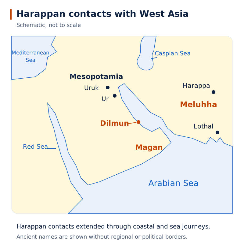
The map marks Meluhha, Magan, Dilmun and Mesopotamia around connected waterways. Harappa, Lothal, Ur and Uruk are labelled, alongside the Arabian Sea, Red Sea, Mediterranean Sea and Caspian Sea.
Drawn by One Young India. Reference: NCERT Class 12 Map 3
How did seals, writing and weights support exchange?
Seals and sealings helped communication over long distances. A seal was the object used to make an impression; a sealing was the impressed clay attached to a package. An intact sealing indicated that the package had not been opened.
How was a package secured?
- The mouth of a bag containing goods was tied with rope.
- Wet clay was fixed onto the knot.
- One or more seals were pressed into the clay, leaving impressions.
- The recipient could inspect the sealing for interference and obtain information about the sender's identity.
The writing on seals probably recorded the owner's name and title. Animal motifs may have communicated meaning to people unable to read. These possible functions should not be confused with an actual translation of the inscriptions.
What is known about the script?
The Harappan script remains undeciphered. Most inscriptions are short; the longest contains about 26 signs. The estimated 375 to 400 signs indicate that it was not an alphabet in which each sign represented a vowel or consonant.
Some inscriptions have wider spacing on the right and crowded signs on the left. This suggests writing from right to left. Inscriptions occur on seals, copper tools, jar rims, tablets, jewellery, bone rods and a signboard, but the extent of literacy remains uncertain.
What were the features of the weight system?
Weights were usually made of chert, generally cubical and unmarked. Smaller denominations followed a binary sequence: 1, 2, 4, 8, 16 and 32. Higher denominations followed a decimal system, with examples including 160, 200, 320 and 640.
Small weights probably measured jewellery and beads; metal scale-pans have also been found. Standardised weights helped regulate exchanges. Their precision provides evidence of organised transactions even though surviving writing cannot yet explain those transactions directly.
Why are Harappan authority and religious beliefs difficult to reconstruct?
Uniform bricks, pottery, seals and weights indicate coordination across settlements. Large walls and platforms required organised labour, while settlements near raw materials suggest strategic decisions. Yet these observations do not directly identify rulers or establish their titles.
What are the competing explanations of authority?
Some archaeologists propose a society without rulers and with equal status; others suggest separate rulers for different cities. Another interpretation proposes a single state, drawing on similarities in objects, planned settlements and standardised brick proportions. It is likely that Harappans practised some sort of democratic system.
The building called a palace lacked spectacular finds confirming that function. The statue called the priest-king was named through comparison with Mesopotamian traditions. It does not prove that Harappan religious specialists also held political power.
Why do religious identifications require caution?
Female terracotta figurines have been interpreted as mother goddesses. The Great Bath and fire altars at Kalibangan and Lothal have been assigned ritual roles. Plant motifs might suggest nature worship, while some animal motifs appear mythical or composite.
A seated, cross-legged figure on certain seals has been identified as proto-Shiva. However, later religious parallels are uncertain. The Rigveda, compiled approximately 1500 BCE to 1000 BCE, describes Rudra without identifying him as a yogi or as Pashupati in the manner proposed for the seal.
Small polished stone cones also permit different interpretations. They have been called lingas, but could have been gaming pieces. Resemblance to a later object is a starting point for investigation, not sufficient proof of religious continuity.
Note: Distinguish an artefact's visible features from the name assigned by an excavator. Labels such as priest-king and mother goddess express interpretations; they do not supply the missing evidence about Harappan political offices or deities.
What caused the decline of cities, and what were its consequences?
After about 1900 BCE, the material culture of occupied Harappan sites changed. By approximately 1800 BCE, most Mature Harappan settlements in areas such as Cholistan had been abandoned. Population expanded into new settlements in Gujarat, Haryana and western Uttar Pradesh.
What changed in the Late Harappan phase?
Distinctive seals, weights and special beads disappeared. Writing, long-distance trade and craft specialisation disappeared with the urban system. People used fewer materials to make fewer kinds of objects. Building techniques deteriorated, and large public structures were no longer constructed.
These changes point towards a more rural way of life in Late Harappan or successor cultures. Urban decline did not mean that every settlement was suddenly deserted or that the population simply vanished. Some places continued to be occupied with altered material practices.
How should proposed causes be evaluated?
Suggested causes include climatic change, deforestation, excessive flooding, rivers shifting or drying up, and overuse of the landscape. Some explanations may apply to particular settlements, but none of these alone explains the collapse of the entire civilisation.
The disappearance of widely shared artefacts and the replacement of standardised weights by local ones suggest that a unifying organisation, perhaps the Harappan state, ended. This remains an inference from material changes rather than a directly recorded political event.
Why was the invasion explanation challenged?
In 1947, R.E.M. Wheeler connected skeletons found at Mohenjodaro with references to Indra as a destroyer of forts. George Dales challenged the massacre interpretation in 1964: the skeletons belonged to different periods, and evidence for extensive burning or a final defence was absent.
This debate shows why a proposed cause must fit the archaeological contexts. Scattered skeletons cannot automatically be combined into evidence for one destructive event.
How did discoveries change the understanding and significance of Harappa?
Ruined Harappan cities were gradually forgotten. Later inhabitants encountered unfamiliar objects exposed by floods, erosion, cultivation or digging. Recognising a civilisation required more than finding an object: archaeologists needed an appropriate chronological and comparative framework.
Why did Cunningham miss Harappa's antiquity?
Alexander Cunningham concentrated on Early Historic and later periods, using texts, inscriptions and Chinese Buddhist pilgrims' accounts. Harappa did not fit that framework. He received a Harappan seal, but failed to recognise how much older it was than the cities he studied.
His 1875 report recorded the seal. He also described severe damage caused by people taking Harappa's bricks for railway construction. Mohenjodaro, in contrast, was much better preserved, illustrating how later activity affects the evidence available for excavation.
How was a new civilisation recognised?
Daya Ram Sahni began excavations at Harappa in 1921; work at Mohenjodaro began in 1922. Sahni and Rakhal Das Banerji found similar seals at the two sites. Their position in older layers suggested a shared culture predating Early Historic settlements.
In 1924, John Marshall announced the discovery of the Indus civilisation. Similar seals already recovered in Mesopotamia helped establish that the two civilisations were contemporaneous. Comparison supplied the context that an isolated seal had lacked.
How did excavation methods develop?
Marshall investigated everyday life as well as spectacular objects, but his uniform horizontal excavation units could mix finds from different layers. After becoming ASI Director-General in 1944, Wheeler emphasised following actual stratigraphy, preserving the cultural sequence more carefully.
After Partition, major known sites lay in Pakistan, prompting searches within India. From the 1980s, international teams increasingly combined surface exploration, specialist analysis and scientific methods to study small fragments of evidence alongside monumental remains.
How do archaeological sources and scientific methods reconstruct the past?
Material evidence is central because Harappan inscriptions cannot yet be read. Stone, terracotta and metal survive more readily than cloth, leather, wood or reeds. The archaeological record therefore preserves some aspects of life much better than others.
How are finds classified and contextualised?
- Classify an object by its material, such as stone, clay, metal, bone or ivory.
- Investigate possible functions, recognising that an object could serve more than one purpose.
- Record whether it came from a house, drain, grave, kiln or another setting.
- Relate it to its archaeological layer and compare it with associated finds or suitable present-day parallels.
Stratigraphy studies layers created through occupation, rebuilding and abandonment. Lower layers are generally older; upper layers are generally more recent. Layers without traces of occupation may indicate abandonment. Their sequence helps assign objects to cultural periods.
What the figure shows
Stratigraphy of a small mound
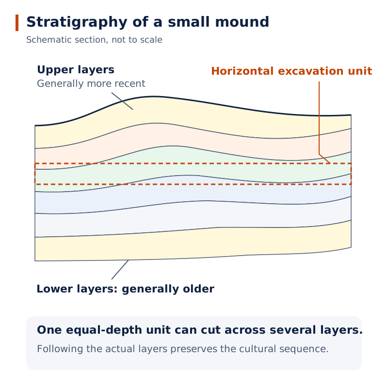
The drawing shows numerous layers bending and sloping across an excavated section. They are not uniformly horizontal, demonstrating why equal-depth excavation units can cross different archaeological deposits.
Drawn by One Young India. See Fig. 1.25 in your NCERT textbook
What can excavation reports reveal?
Ernest Mackay's 1937 discussion of querns used form, wear and comparison with modern grinding stones to infer functions. His 1948 account described drains, removable covers and cleaning arrangements. These reports connect interpretations with specific observations.
John Marshall's 1931 account described skeletal finds in Deadman Lane. Dales's 1964 reassessment showed how checking the contexts could overturn an earlier interpretation. Reports must therefore be examined for both the evidence recorded and the conclusions drawn from it.
What does archaeogenetics add?
Archaeogenetics uses ancient DNA to investigate population history. Vasant Shinde began archaeogenetic research at Rakhigarhi in 2013. DNA extracted from excavated skeletal remains was studied in research involving institutions in Pune and Hyderabad and collaborators at Harvard.
The Rakhigarhi research published in 2019 examined genetic ancestry and continuity. The researchers interpreted their findings as indicating local origins, ancestry continuing in South Asian populations and some genetic mixing through wider contacts. Ancient DNA adds biological evidence to the study of material remains. Questions about Harappan and Vedic relationships remain subjects for further research, alongside unresolved issues of language, literacy, gender and religious practice.
Surviving finds are also selective because broken objects were discarded, while useful materials could be recycled. Intact valuables might represent losses or unretrieved hoards. Their survival is often accidental, so an exceptional object need not represent ordinary everyday possessions.
What timeline connects Harappan phases with their archaeological discovery?
Two chronologies must be kept separate: the ancient development of Harappan communities and the much later discovery and interpretation of their remains. Dates such as 2600 BCE describe the civilisation; dates such as 1924 describe modern archaeological work.
Which dates mark the principal developments?
| Date or period | Development |
|---|---|
| Around 7000 BCE | Early farming communities provide the background to later Harappan development. |
| 6000 BCE to 2600 BCE | Early Harappan formative phase. |
| 2600 BCE to 1900 BCE | Mature Harappan urban phase. |
| 1900 BCE to 1300 BCE | Late Harappan phase, with declining urban features and successor cultures. |
| 1875 | Alexander Cunningham reports on a Harappan seal. |
| 1921 | Daya Ram Sahni begins excavations at Harappa. |
| 1922 | Excavations begin at Mohenjodaro. |
| 1924 | John Marshall announces the discovery of the Indus civilisation. |
| 1925 | Sixteen skeletons are found in the same part of Mohenjodaro, later becoming part of the debate over a massacre. |
| 1931 | John Marshall publishes his account of Mohenjodaro, including skeletal finds in Deadman Lane. |
| 1937 | Ernest Mackay discusses querns in his report on further excavations at Mohenjodaro. |
| 1944 | Wheeler becomes ASI Director-General and brings greater attention to stratigraphic excavation. |
| 1946 | R.E.M. Wheeler excavates at Harappa. |
| 1948 | Mackay's Early Indus Civilisation describes drainage arrangements and discusses interpretations of stone objects. |
| 1955 | S.R. Rao begins excavations at Lothal. |
| 1960 | B.B. Lal and B.K. Thapar begin excavations at Kalibangan. |
| 1964 | George Dales challenges the interpretation of a massacre at Mohenjodaro. |
| 1974 | M.R. Mughal begins explorations in Bahawalpur. |
| 1980 | A German and Italian team begins surface explorations at Mohenjodaro. |
| 1986 | An American team begins excavations at Harappa. |
| 1990 | R.S. Bisht begins excavations at Dholavira. |
| 1997 | Amrendra Nath starts excavations at Rakhigarhi. |
| 2013 | Vasant Shinde begins archaeogenetic research at Rakhigarhi. |
| 2019 | Rakhigarhi ancient-DNA research by Vasant Shinde and collaborators is published. |
The ancient phase boundaries are approximate. They organise broad changes rather than fixing every settlement to an identical timetable. The discovery dates record successive investigations, showing how knowledge expanded through excavation, regional surveys and scientific analysis.
Glossary
- Artefact — An object made or used by people, such as pottery, a tool, an ornament or a seal.
- Subsistence strategies — The ways communities obtained food through activities such as cultivation, animal rearing, hunting and fishing.
- Archaeo-botanist — A specialist who studies ancient plant remains, including charred seeds and grains recovered during excavation.
- Zoo-archaeologist — A specialist studying animal remains to investigate species, domestication and the use of animals in the past.
- Citadel — The smaller, elevated part of settlements such as Mohenjodaro, physically separated from the Lower Town.
- Quern — A grinding stone used with another stone to process grain or other materials into smaller particles.
- Faience — A material produced by firing ground sand or silica mixed with colour and a gum.
- Steatite — A soft stone used to manufacture seals and beads, including beads moulded from a powdered paste.
- Hoards — Objects stored carefully, often in containers, which survive when their owners do not return to retrieve them.
- Sealing — Clay bearing a seal impression, attached to a package to communicate identity and reveal interference.
- Stratigraphy — The study of archaeological layers to establish the sequence of occupation and relate finds to cultural periods.
- Archaeogenetics — The study of ancient populations through DNA, using molecular genetic methods to investigate population history.
Common errors and misconceptions
- Misconception: Harappan civilisation means only the period from 2600 BCE to 1900 BCE. Correct: Those dates identify its Mature urban phase; Early and Late phases extend the chronology.
- Misconception: Every Harappan settlement had an identical Citadel. Correct: Layouts varied; Lothal's elevated Citadel was not separately walled.
- Misconception: Jewellery in a grave proves that the deceased was female. Correct: Jewellery has been found with both men and women.
- Misconception: Harappan writing has been translated. Correct: The script remains undeciphered, although its probable direction and approximate number of signs are known.
- Misconception: The priest-king statue proves rule by priests. Correct: Its name reflects an archaeological interpretation; the relationship between ritual and political authority remains uncertain.
- Misconception: One natural disaster explains every city's decline. Correct: Proposed environmental causes may explain particular settlements, but do not individually account for the entire transformation.
- Misconception: All skeletons at Mohenjodaro prove one invasion and massacre. Correct: Dales showed that the remains belonged to different periods and lacked the required shared destruction context.
- Misconception: An object resembling a later religious symbol must have had the same meaning. Correct: Such comparisons remain speculative without supporting contextual evidence.
Exam-style questions with model answers
Q1. A Kalibangan field from Early Harappan levels contains two sets of furrows crossing at right angles. What agricultural activity does the field demonstrate, and what does the pattern suggest? [2 marks]
- The furrows provide evidence that the land was ploughed.
- The crossing sets suggest that two different crops were grown together. This is an inference from the pattern, rather than identification of particular crops.
Q2. At Mohenjodaro, streets intersected at right angles, house drains connected to street drains, and the main channels had removable covers. Explain three ways these details indicate planning. [3 marks]
- The intersecting streets formed an approximate grid, indicating an organised layout rather than unrelated building activity.
- Connections between house drains and street drains required houses to be positioned so that waste water could reach the common system.
- Removable covers allowed access for cleaning. Planning therefore addressed continued maintenance as well as the original construction of drains.
Q3. Jewellery occurs in both male and female Harappan burials. Most ordinary objects occur widely, but rare faience pots are concentrated in larger settlements. Give three conclusions about social differences and the limits of this evidence. [3 marks]
- Jewellery cannot by itself establish the sex of a buried person, because it occurs with both men and women.
- The wider distribution of ordinary objects contrasts with the concentration of rare pots, suggesting differences in access to rare goods.
- These patterns support investigation of social differences, but they do not establish a complete hierarchy or identify each person's rank.
Q4. A craft area contains stone nodules, specialised drills, unfinished beads and tiny stone offcuts. Explain how each find supports identifying it as a bead-production centre rather than merely a place where beads were used. [4 marks]
- Stone nodules provide evidence of raw material brought into the production area before it became a finished object.
- Specialised drills supply evidence of tools needed to make holes in beads.
- Unfinished beads show that objects were present at intermediate stages of manufacture, rather than arriving only as completed ornaments.
- Tiny stone offcuts are waste from working the raw material. Together, materials, tools, unfinished products and waste strongly support local manufacture.
Q5. Harappan cities shared brick proportions and weights, used planned layouts, mobilised labour for walls, and established settlements near raw materials. No securely identified ruler is known; the names palace and priest-king are interpretations. Proposals include a single state or several rulers. Evaluate the case for organised authority and the limits of identifying its form. [6 marks]
- Shared brick proportions and weights indicate coordination across production and exchange, rather than completely independent local practices.
- Planned layouts required decisions about the arrangement of streets and buildings before construction was completed.
- Large walls demanded labour mobilisation, while settlements near resources suggest decisions about obtaining materials.
- These observations support the existence of organised authority, but do not directly identify the individuals or institutions making decisions.
- Calling a building a palace or a statue a priest-king cannot establish a monarchy or rule by religious specialists when those labels are interpretations.
- The evidence therefore allows competing explanations, including a single coordinating state or several centres of authority. Organisation is clearer than its exact political form.
Q6. After 1900 BCE, distinctive seals and weights, craft specialisation and long-distance trade disappeared, large public buildings ceased, and settlements showed a more rural way of life. Climate change, floods, deforestation and river shifts are proposed causes, but some apply only locally. Explain the transformation and why a single-cause explanation is inadequate. [6 marks]
- The disappearance of distinctive seals and weights suggests a weakening of the shared practices that had connected urban settlements.
- The disappearance of craft specialisation and long-distance trade indicates that the earlier economic organisation was changing.
- The end of large public construction marks another difference from the urban phase, when such buildings required substantial coordinated work.
- A more rural settlement pattern indicates transformation of life rather than proof that the population vanished completely.
- Floods, river shifts, climatic change and deforestation could affect particular locations differently. Evidence for one local cause cannot automatically be extended to every settlement.
- A convincing explanation must therefore account for the wider combination of changes while recognising regional variation and uncertainty about their causes.
Q7. In 1947 Wheeler linked Mohenjodaro skeletons with an invasion. In 1964 Dales argued that the skeletons belonged to different periods and that extensive burning and evidence of a final defence were absent. Assess the invasion interpretation using only these observations. [4 marks]
- Skeletons from different periods cannot automatically be treated as victims of one simultaneous attack.
- The absence of extensive burning weakens the claim that the remains demonstrate large-scale destruction across the city.
- The lack of evidence for a final defence also leaves an important part of the proposed invasion unsupported.
- Dales's reassessment therefore undermines this particular massacre explanation. It demonstrates the need to check archaeological contexts before combining finds into a historical narrative.
Q8. Marshall excavated uniform horizontal units that could combine objects from different layers. Wheeler instead followed actual stratigraphy. Explain why Wheeler's approach better preserved chronological information. [2 marks]
- Actual layers represent different phases of occupation. Following them keeps finds associated with their archaeological contexts.
- Uniform horizontal units may cut across several layers, mixing objects from different periods and obscuring the site's cultural sequence.
Key takeaways
- The Mature Harappan urban phase lasted approximately from 2600 BCE to 1900 BCE, within a longer developmental history.
- Grains, animal bones, plough models and field remains reveal food production, while leaving some farming practices uncertain.
- Mohenjodaro's platforms, standardised bricks, street grid, bathrooms and drains demonstrate planning at both civic and domestic scales.
- Burials and unequal distributions of valuable objects help identify social differences without revealing a complete hierarchy.
- Tools, raw materials, unfinished products and waste provide stronger evidence of manufacturing than finished objects alone.
- Regional and overseas contacts supplied materials, while seals, sealings and standardised weights supported communication and exchange.
- Harappan authority and religion remain open to competing interpretations because artefacts do not directly identify offices or beliefs.
- Careful excavation, stratigraphy and reassessment of evidence can change historical explanations, including accounts of urban decline.
Test yourself
How is a seal different from a sealing?
A seal is the object pressed into clay; a sealing is the clay bearing its impression, often attached to goods.
Why are tiny production offcuts useful to archaeologists?
Larger pieces could be reused, but tiny waste fragments often remained in the work area and help identify craft production.
What gives Mohenjodaro's Citadel its height?
Its buildings stood on mud-brick platforms, making this smaller section higher than the larger Lower Town.
Why is the Harappan script considered non-alphabetical?
Its estimated 375 to 400 signs are too numerous for an alphabet in which signs represent individual vowels or consonants.
What is uncertain about wild animal bones at Harappan sites?
They do not establish whether Harappans hunted the animals themselves or obtained meat from other hunting communities.
What did John Marshall announce in 1924?
He announced the discovery of a civilisation in the Indus valley, following recognition of related finds at Harappa and Mohenjodaro.
Why can a valuable intact object be unrepresentative of everyday disposal?
It may have been lost or stored in an unretrieved hoard; useful or valuable objects were not normally discarded intact.
Why does the Great Bath's construction not identify a particular deity?
Its form and setting suggest a special ritual purpose, but do not provide direct evidence naming a deity or ceremony.