
Our World: Latitudes, Longitudes and Time | ICSE Class 9 Geography Notes
On this page
This note covers the geographical grid, latitudes and important parallels, longitudes and hemispheres, locating places, great circles, local time, longitude calculations, Indian Standard Time, time zones and the International Date Line.
What is the geographical grid and why is it needed?
The geographical grid is the network of imaginary lines used to locate places on the Earth. It combines parallels of latitude, which run east-west, with meridians of longitude, which run from pole to pole. The two sets of lines provide references for describing position.
The Earth is nearly a sphere, slightly flattened at the poles. A globe is a spherical model on which its geography can be represented. A flat map represents the curved surface on paper, but cannot preserve all its properties without distortion.
What are the reference points?
The Earth's axis is the imaginary line about which it spins. Its two ends provide the North Pole and South Pole. The Equator is the circle midway between these poles. These references make it possible to establish an orderly system of locations.
A hemisphere is half of the globe. The Equator separates the Northern Hemisphere from the Southern Hemisphere. A place's position north or south of the Equator is described by latitude; its position east or west of the reference meridian is described by longitude.
How do coordinates work?
Geographical coordinates are the latitude and longitude used together to specify a position. One coordinate alone leaves many possible positions. Their combination identifies where a selected parallel and meridian intersect, meaning where the two lines cross.
Think of a location described by a particular shop and a particular row in a market. Both pieces of information are needed. Similarly, latitude selects a parallel and longitude selects a meridian. Although infinitely many grid lines can be imagined, only selected lines are usually drawn on maps.
How is latitude measured and written?
Definition: Latitude is the angular distance of a place north or south of the Equator, measured at the Earth's centre along that place's meridian.
An angular distance expresses separation as an angle rather than a length on the ground. Latitude uses degrees, written with the symbol °. Each degree contains 60 minutes of angle, written ′; each minute contains 60 seconds of angle, written ″.
These angular minutes and seconds describe parts of an angle. They must be distinguished from minutes and seconds of clock time. Writing units clearly prevents confusion when longitude angles are later converted into differences in local time.
What do the letters mean?
The Equator has latitude 0°. Latitude increases towards either pole, reaching 90°N at the North Pole and 90°S at the South Pole. Here N means north and S means south. The letter identifies the side of the Equator.
A parallel of latitude joins places having the same latitude. Parallels run east-west and remain parallel to the Equator. They become smaller towards the poles. The Equator is the largest parallel; the poles themselves are points.
If parallels are drawn at one-degree intervals, there are 89 between the Equator and each pole. Including the Equator gives 179 such circles. This is a count for that selected interval, not a limit on the number of possible latitudes.
What the figure shows
Parallels of latitude
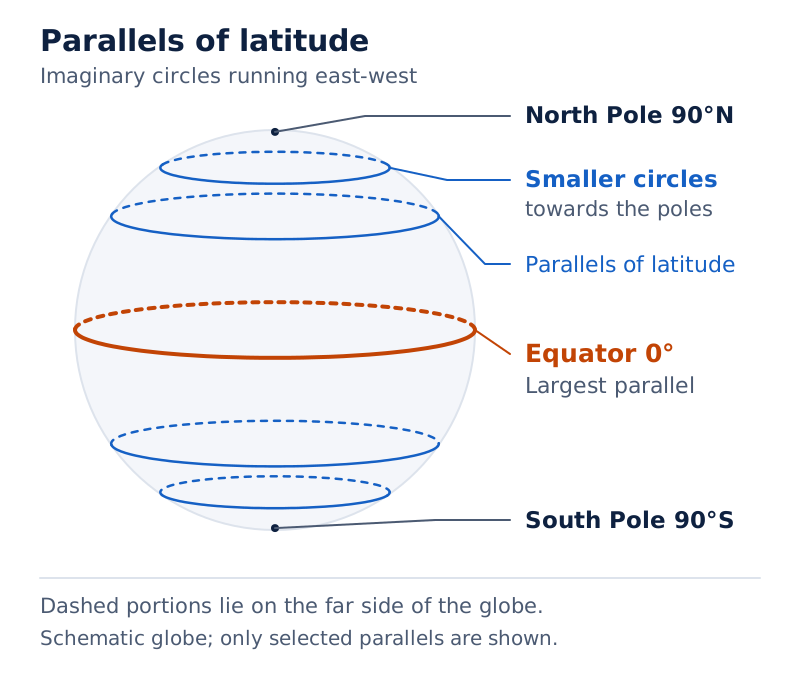
The globe shows the Equator and a series of parallel circles. The circles become smaller towards the labelled North Pole, illustrating how their size changes with latitude.
Drawn by One Young India.
Which main latitudes divide the Earth into broad heat zones?
The main latitudes provide convenient reference lines for location and for broad divisions based on temperature. Learn each line's name together with its value and hemisphere. The same numerical latitude can occur north or south, so the direction is part of the location.
| Reference line or point | Latitude | Position |
|---|---|---|
| North Pole | 90°N | Northern end of the axis |
| Arctic Circle | 66½°N | Northern polar circle |
| Tropic of Cancer | 23½°N | Northern tropic |
| Equator | 0° | Midway between the poles |
| Tropic of Capricorn | 23½°S | Southern tropic |
| Antarctic Circle | 66½°S | Southern polar circle |
| South Pole | 90°S | Southern end of the axis |
What do the heat-zone names mean?
The Torrid Zone is the broadly hot belt between the tropics. Its northern and southern parts extend from 0° to 23½°. Around the Equator, the climate is generally hot. Keep “generally” in this explanation: a broad latitude zone is not a complete description of every place's climate.
The Temperate Zones are the broadly moderate belts extending from 23½° to 66½° in each hemisphere. The Frigid Zones are the cold polar belts extending from 66½° to 90°. The Arctic and Antarctic Circles mark the boundaries nearer the poles.
Latitude therefore serves two linked purposes: it helps locate a place and helps identify its broad temperature zone. Moving away from the Equator increases latitude while the parallels themselves become smaller. Increasing latitude does not mean an increasing circumference, or distance around the parallel.
When labelling a globe, begin with the Equator and poles, then add the tropics and polar circles in order. Keep north and south labels attached to their values. The matching numerical boundaries in the two hemispheres make the arrangement easier to understand.
What are longitudes and how do they divide the hemispheres?
Definition: Longitude is the angular distance of a place east or west of the Prime Meridian, measured in degrees.
A meridian of longitude is an imaginary semicircle joining the North Pole and South Pole. Meridians meet, or converge, at the poles. They are farthest apart at the Equator and cross it at right angles. A right angle measures 90°.
The Prime Meridian is the reference meridian assigned longitude 0°. It passes through Greenwich, an area of London in England, and is also called the Greenwich Meridian. Longitudes are measured eastward and westward from this reference.
How are longitude values expressed?
Longitude values extend from 0° to 180° in either direction. The letter E means east and W means west. The expressions 180°E and 180°W identify the same meridian, so it can simply be written as 180°.
The Eastern Hemisphere lies east of the Prime Meridian as far as the opposite meridian. The Western Hemisphere lies west of it. The Prime Meridian and the 180° meridian together form the boundary between these two halves of the globe.
Each meridian is a half-circle. An opposite pair completes a circle, but the two meridians retain separate longitude values. Do not confuse the full circle made by the pair with one individual meridian.
Using rounded figures, Delhi's longitude is 77°E, New York's is 74°W and Tokyo's is 140°E. These indicate their positions relative to Greenwich. The values are rounded, so they should not be presented as exact coordinates.
How do parallels of latitude differ from meridians of longitude?
Both sets of lines belong to the same coordinate system, but their shapes, reference lines and uses differ. Latitude describes north-south position even though its parallels run east-west. Longitude describes east-west position even though its meridians run north-south.
| Feature | Parallels of latitude | Meridians of longitude |
|---|---|---|
| Reference | Equator at 0° | Prime Meridian at 0° |
| Measurement | North or south, up to 90° | East or west, up to 180° |
| Shape on a globe | Circles, becoming points at the poles | Semicircles joining the poles |
| Relative length | Smaller towards the poles | Equal in length |
| Relationship between lines | Parallel to the Equator | Converge at the poles |
| Important application | Locating places and identifying broad temperature zones | Locating places and calculating local time |
Does one degree mean the same ground distance everywhere?
The distance represented by one degree of latitude changes slightly from the Equator to the poles because the Earth is not a perfect sphere. It is 110.6 kilometres at the Equator and 111.7 kilometres at the poles. A kilometre, abbreviated km, is a unit of distance.
If the Earth were a perfect sphere, the one-degree latitude distance would be constant, about 111 km. Retain that condition when explaining the value. A useful approximation should not become a claim that the real Earth has exactly equal one-degree distances everywhere.
For longitude, the important contrast is the convergence of meridians. Their separation decreases towards the poles, where they meet. Equal angular differences in longitude therefore do not represent equal east-west distances at all latitudes.
Choose the measurement according to the task. Use both coordinates to locate a place, latitude to identify its broad north-south position and temperature zone, and longitude to calculate its local-time difference from another meridian.
How can latitude and longitude be used to locate a place?
To locate a place, use its latitude and longitude together. First identify the correct sides of the Equator and Prime Meridian. Then follow the required parallel and meridian to their intersection. A numerical value without its direction can leave the location ambiguous.
Case study: locating Delhi and comparing Bengaluru
Delhi lies at approximately 29°N, 77°E. These are rounded coordinates. The latitude places it north of the Equator, while the longitude places it east of Greenwich. Their intersection gives its approximate position on the geographical grid.
- Find the Equator, which provides the starting reference for latitude.
- Move north to the parallel marked 29°N, using the rounded latitude given.
- Find the Prime Meridian and then the meridian marked 77°E.
- Identify the intersection of that parallel and meridian as Delhi's approximate position.
Bengaluru's latitude is given as 13°N, while the two cities' longitudes are almost the same, 77°E. Their north-south positions differ, but their almost equal longitudes mean their local times are approximately the same. Latitude alone does not determine this time difference.
What the figure shows
India's geographical grid
The map shows India's outline with blue dashed parallels labelled 10°N, 20°N and 30°N, and meridians labelled 70°E, 80°E and 90°E. Read a latitude and longitude together to identify a position.
On a map with selected grid lines, a place may lie between labelled lines. Its position must then be estimated between them. Such a reading is approximate; it should not be described as an exact coordinate obtained from a coarsely labelled map.
What are great circles and why are they useful?
A great circle is a circle on a sphere whose plane passes through the sphere's centre, dividing it into equal halves. A plane is a flat surface extended in all directions. The Equator is a great circle on the globe.
A small circle divides the globe into unequal parts. Parallels other than the Equator are small circles. Their size decreases towards the poles, whereas a great circle has the largest possible circumference on the same sphere.
How are great circles related to meridians?
An individual meridian is a semicircle. Combined with the meridian opposite it, it forms a complete great circle passing through both poles. The distinction between a semicircle and the complete circle is essential when describing meridians.
Therefore, the Equator is the only parallel that is a great circle, but it is not the only possible great circle. Opposite meridian pairs also give great circles. Great circles need not all follow the east-west direction of the Equator.
What is their use in travel?
The shorter arc of a great circle gives the shortest surface route between two places on a spherical globe. An arc is part of a circle. Great-circle routes are often used in air and ocean navigation, meaning the planning and following of travel routes.
“Often” matters: this use does not mean that every aircraft or ship must follow a great circle. The geographical principle identifies the shortest route on the spherical model. It should not be turned into an absolute claim about every journey.
Diagram
Great and small circles
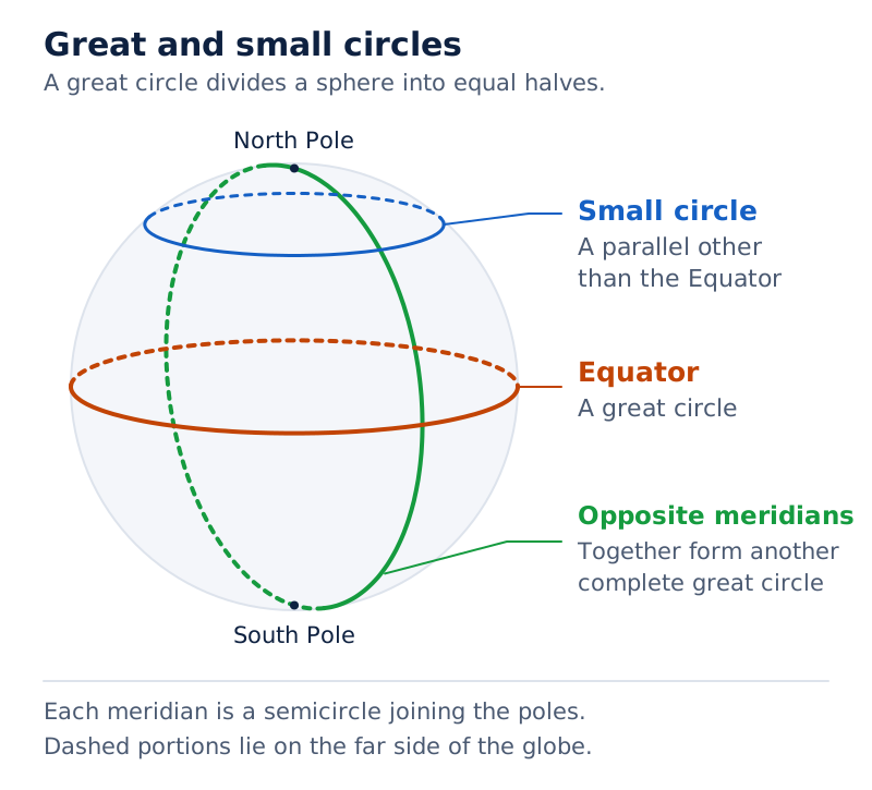
Draw a globe with the Equator and another parallel. Label the Equator as a great circle and the other parallel as a small circle. Add an opposite meridian pair through the poles to show another complete great circle.
Drawn by One Young India.
Why does local time change with longitude?
Local time is time determined with reference to the Sun's position at a particular meridian. Because the Earth rotates from west to east, places at different longitudes face the Sun at different stages of the daily rotation.
The Earth completes a full rotation of 360° in 24 hours. This gives a rotation through 15° of longitude in one hour. Since an hour contains 60 minutes of time, a difference of one degree corresponds to four minutes of time.
Which direction is ahead?
For a comparison at the same instant, places to the east are ahead in local time, while places to the west are behind. When Greenwich has noon, eastern meridians have later local times and western meridians have earlier local times.
Greenwich Mean Time, abbreviated GMT, provides the reference time associated with the Greenwich Meridian. Distinguish this time reference from the Prime Meridian itself: GMT is a time, while the Prime Meridian is the line of longitude from which longitude values are measured.
| Rotation or longitude difference | Corresponding time | Meaning |
|---|---|---|
| 360° | 24 hours | One complete rotation |
| 15° | 1 hour | Hourly rate of rotation |
| 1° | 4 minutes | Conversion for local-time calculations |
For instance, when it is noon at Greenwich, local time is 1 in the afternoon at 15°E and 11 in the morning at 15°W. The angular separation is equal, but the direction changes whether time is added or subtracted.
Places on the same meridian have the same local time in this geographical calculation. Differences in latitude do not create a longitude-based time difference. This is why both the angle and the direction of longitude matter when comparing clocks.
How are longitude-based time calculations solved?
Begin with the given longitudes and reference time. Calculate the angular separation, convert it to a time interval, and then decide whether the required place lies east or west of the reference place. Avoid choosing addition or subtraction from the longitude letter alone.
What is the calculation method?
- Write the reference place's longitude and known local time, followed by the required place's longitude.
- For longitudes on the same side of Greenwich, subtract the smaller value from the larger. For opposite sides, add their angular distances from Greenwich.
- Multiply the longitude difference in degrees by four to obtain the time difference in minutes.
- Add the interval for a place east of the reference place; subtract it for a place west of the reference place.
- Express the result clearly in hours and minutes, distinguishing morning, afternoon, noon or midnight. Check the date if the calculation passes midnight.
How do the eastern and western examples work?
Worked example 1. Take Thimpu at the exercise longitude of 90°E. Find its local time when Greenwich, at 0°, has noon. Use four minutes of time for each degree of longitude.
Answer: The difference is 90°. Multiplying 90 by 4 gives 360 minutes, or 6 hours. Thimpu is east of Greenwich, so add 6 hours to noon. Its local time for the given longitude is 6 in the evening.
Worked example 2. Take New Orleans at the exercise longitude of 90°W. Find its local time when Greenwich, at 0°, has noon, again using four minutes per degree.
Answer: The angular difference is again 90°, giving 360 minutes or 6 hours. New Orleans is west of Greenwich, so subtract 6 hours from noon. Its local time for the given longitude is 6 in the morning.
Note: These are local-time calculations using the supplied longitudes. A country's standard clock time is a separate matter and depends on its adopted standard meridian or time zone.
Why does India use a standard time?
Standard time is the time adopted for common use in a country or a time zone, based on a selected meridian. Using numerous local times within a country would be inconvenient. Most countries therefore adopt a standard time based on a meridian passing through them.
Case study: Indian Standard Time
Indian Standard Time, abbreviated IST, is based on the 82°30′E meridian passing through Mirzapur. A standard meridian is the meridian selected as the reference for standard time. Its time is used for the country rather than a different local time at every longitude.
The 30′ in 82°30′ means 30 angular minutes, equal to half a degree because one degree contains 60 angular minutes. Thus, 82°30′E is 82½°E. The half-degree must be retained when calculating the time difference from Greenwich.
- Compare India's standard meridian, 82½°E, with Greenwich at 0°.
- Multiply 82½ by 4 minutes per degree to obtain 330 minutes of time.
- Convert 330 minutes into 5 hours and 30 minutes.
- Since the standard meridian lies east of Greenwich, IST is 5 hours 30 minutes ahead of GMT.
Consequently, when GMT is noon, IST is 5:30 in the afternoon. The expression 5.5 hours also means five and a half hours. Do not read it as five hours and five minutes.
Does standard time remove local-time differences?
No. Consider Porbandar in Gujarat and Tinsukia in Assam. For the simplified exercise difference of 30° longitude, their local-time difference is two hours. Tinsukia is farther east, so its local time is ahead. Both places nevertheless use IST.
The 30° separation is an exercise assumption, not a precise measured separation of those cities. The example distinguishes a common standard clock reading from the differing local times associated with their east-west positions.
How are time zones arranged across the world?
A time zone is an area using a common standard time. The world is divided into 24 major time zones, linked to the Earth's 24-hour rotation. A basic one-hour zone corresponds to 15° of longitude.
Actual boundaries broadly follow the 15° divisions. They are not fully straight because they must accommodate countries' standard times and tend to follow international borders. Treat the regular meridian pattern as a starting model, not as the exact shape of every boundary.
How are differences from Greenwich shown?
A time-zone map may show a positive sign, written +, for hours added to GMT, or a negative sign, written −, for hours subtracted from GMT. These signs state a time difference; they are not latitude or longitude measurements.
What the figure shows
World time zones
The map shows countries, irregular time-zone boundaries and numbers indicating differences from GMT. The International Date Line is labelled near the map's left edge. The map is not to scale, and its international borders are approximate, not exact.
Why can a country have more than one time zone?
Countries with a large east-west extent may choose more than one standard meridian. Russia, Canada and the United States of America provide examples. A single national time zone is therefore not a rule applying to every country.
Distinguish three ideas when reading a time-zone map: longitude gives geographical position, local time follows that longitude, and standard time is the adopted common time. Knowing a place's longitude permits a local-time calculation, but its standard clock reading requires its adopted time-zone information.
India illustrates a standard-time difference of half an hour as well as whole hours. Its five-hour-thirty-minute difference from Greenwich shows why standard times should not all be assumed to differ from GMT by a whole number of hours.
What is the International Date Line and how does crossing it change the date?
The International Date Line, abbreviated IDL, is the line across which the calendar date changes by one day. It lies approximately at 180° longitude, opposite the Prime Meridian. “Approximately” is essential because its course deviates in places.
The line avoids dividing some countries into two different calendar days. Therefore, the IDL and the 180° meridian are closely related but should not be described as following exactly the same path everywhere.
Which date adjustment is made?
Crossing the IDL eastward means subtracting one calendar day. Crossing it westward means adding one calendar day. These are adjustments made on crossing the date boundary, distinct from adding or subtracting local-time intervals between ordinary meridians.
| Direction of crossing | Date adjustment | Example |
|---|---|---|
| Eastward | Subtract 1 day | Monday becomes Sunday |
| Westward | Add 1 day | Sunday becomes Monday |
Why is a date boundary necessary?
At the opposite side of the globe from Greenwich, the idealised time differences reach twelve hours ahead and twelve hours behind. Those two time readings are separated by a full day. A date boundary makes the calendar consistent as people travel around the world.
The IDL resolves the change of date, while time zones organise standard clock times. Greenwich is the reference for longitude and GMT; the date boundary lies on the opposite side of the globe. Do not interchange their roles.
Keep two rules separate in calculations: eastward positions have later local times when compared at the same instant, but an eastward crossing of the IDL requires a calendar day to be subtracted. Identify which kind of question is being asked before applying either rule.
Glossary
- Geographical grid — The network of intersecting parallels and meridians used to locate places on the Earth.
- Latitude — Angular distance north or south of the Equator, measured at the Earth's centre.
- Parallel — An imaginary circle joining places with the same latitude, parallel to the Equator.
- Equator — The largest parallel, at zero degrees latitude, dividing the globe into northern and southern halves.
- Longitude — Angular distance east or west of the Prime Meridian, measured in degrees.
- Meridian — An imaginary semicircle joining the North and South Poles through places of the same longitude.
- Prime Meridian — The reference meridian passing through Greenwich and assigned the longitude of zero degrees.
- Geographical coordinates — The latitude and longitude used together to identify a place's position on the globe.
- Great circle — A circle whose plane passes through a sphere's centre and divides it into equal halves.
- Local time — Time determined with reference to the Sun's position at a particular meridian.
- Standard time — The common time adopted for a country or time zone using a selected meridian.
- Greenwich Mean Time — The reference time associated with the Greenwich Meridian, commonly abbreviated as GMT.
- Indian Standard Time — India's common time, based on 82°30′E and five hours thirty minutes ahead of GMT.
- Time zone — An area that uses a common standard time for its clocks.
- International Date Line — The date boundary approximately at 180° longitude, across which the calendar changes by one day.
Common errors and misconceptions
- Misconception: Latitude measures east-west position because parallels run east-west. Correct: Latitude measures angular distance north or south of the Equator.
- Misconception: All parallels have equal lengths. Correct: The Equator is the largest parallel; other parallels become smaller towards the poles.
- Misconception: A single meridian is a complete great circle. Correct: It is a semicircle; an opposite pair makes a complete great circle.
- Misconception: 82°30′ means 82.30 degrees. Correct: Thirty angular minutes equal half a degree, so the value is 82.5 degrees.
- Misconception: Eastward local-time calculations require subtraction. Correct: A place east of the reference place is ahead in local time, so add the calculated interval.
- Misconception: Every place using IST has the same local time. Correct: Their standard clocks agree, but different longitudes have different local times.
- Misconception: Every country uses exactly one time zone. Correct: Countries with a large east-west extent may use several time zones.
- Misconception: The IDL follows 180° exactly and adds a day when crossed eastward. Correct: It lies approximately at 180°, and eastward crossing subtracts one day.
Exam-style questions with model answers
Q1. Distinguish latitude from longitude by stating the reference line and direction of measurement for each. [2 marks]
- Latitude is the angular distance north or south of the Equator, which is the reference line at 0° latitude.
- Longitude is the angular distance east or west of the Prime Meridian, which is the reference line at 0° longitude.
Q2. Delhi's rounded coordinates are 29°N, 77°E. Explain what each coordinate means and how the two locate Delhi on a globe. [3 marks]
- The latitude 29°N places Delhi north of the Equator, the reference parallel at 0°. The letter N supplies the direction of the angular measurement.
- The longitude 77°E places Delhi east of the Prime Meridian through Greenwich. The letter E supplies the direction from this reference meridian.
- Delhi's approximate position is at the intersection of the 29°N parallel and 77°E meridian. Because the question supplies rounded coordinates, this location should be described as approximate.
Q3. The Earth rotates through 360° in 24 hours, and an hour contains 60 minutes. Using these data, calculate the local time at the exercise longitude of Thimpu, 90°E, when Greenwich at 0° has noon. Show the conversion and direction. [4 marks]
- Dividing the full rotation, 360°, by 24 hours gives a rotation rate of 15° per hour.
- Since one hour contains 60 minutes, each degree corresponds to 60 divided by 15, or four minutes of time.
- The longitude difference from Greenwich is 90°. Multiplying 90 by four gives 360 minutes, equal to six hours.
- Thimpu's given longitude lies east of Greenwich, so its local time is ahead. Adding six hours to noon gives 6 in the evening.
Q4. For this exercise, New Orleans is at 90°W and Greenwich is at 0°. Greenwich has noon, and one degree of longitude corresponds to four minutes of time, and an hour contains 60 minutes. Find New Orleans' local time, showing the time interval and the direction adjustment. [3 marks]
- The angular difference between Greenwich at 0° and the supplied New Orleans longitude of 90°W is 90°. Its westward position determines the direction of the time adjustment.
- At four minutes per degree, the time difference is 90 multiplied by four, giving 360 minutes. This interval is equal to six hours.
- New Orleans lies west of the reference meridian, so subtract six hours from noon. The local time for the given longitude is therefore 6 in the morning.
Q5. India's standard meridian is 82°30′E, while Greenwich is at 0°. One degree contains 60 angular minutes, and one degree of longitude corresponds to four minutes of time, and an hour contains 60 minutes. Explain why a common standard time is useful, then calculate IST when GMT is noon. [5 marks]
- A common standard time avoids the inconvenience of using different local times at different longitudes within a country. Standard clocks can follow one selected reference meridian.
- The supplied standard meridian is 82°30′E. Since a degree contains 60 angular minutes, 30′ is half a degree, making the longitude 82½°E.
- The angular difference from Greenwich at 0° is 82½°. Multiplying 82½ by four minutes per degree gives a time difference of 330 minutes.
- Dividing 330 minutes into hours and minutes gives five hours and thirty minutes. The eastern position means that Indian Standard Time is ahead of GMT.
- Add five hours and thirty minutes to the given Greenwich time of noon. The resulting Indian Standard Time is 5:30 in the afternoon.
Q6. Define a great circle, identify the Equator and an opposite meridian pair as examples, distinguish other parallels, and explain the use of great-circle routes. [5 marks]
- A great circle has a plane passing through the centre of a sphere. It divides that sphere into two equal halves, providing the defining geometrical property.
- The Equator is a great circle because it divides the globe into equal northern and southern halves. It is the largest parallel of latitude.
- Two opposite meridians together form another complete great circle through the poles. Each individual meridian is a semicircle, rather than the full circle.
- Other parallels of latitude are small circles. They divide the globe into unequal parts and become smaller as their distance from the Equator increases.
- The shorter great-circle arc gives the shortest surface route on a spherical globe. Such routes are often used in air and ocean navigation, without implying that every journey follows them.
Q7. Two travellers independently cross the International Date Line: one travels eastward on Monday, and the other westward on Sunday. State the date after each crossing, then explain why the line lies only approximately at 180° longitude. [3 marks]
- The traveller crossing eastward subtracts one calendar day. The Monday given in the question therefore becomes Sunday on the other side of the International Date Line.
- The traveller crossing westward adds one calendar day. The Sunday given in the question therefore becomes Monday after crossing the date boundary.
- The International Date Line lies approximately at 180° longitude because it deviates in places to avoid dividing some countries into two different calendar days.
Q8. Use the exercise coordinates Delhi 29°N, 77°E and Bengaluru 13°N, 77°E. Explain their relative north-south positions and their local-time relationship. Treat the supplied longitudes as equal. [2 marks]
- Delhi lies farther north because its given northern latitude, 29°N, is greater than Bengaluru's 13°N.
- Their local times are equal for this exercise because both supplied longitudes are 77°E. The latitude difference does not create a local-time difference.
Key takeaways
- The geographical grid combines parallels and meridians; latitude and longitude together identify a place's position.
- Latitude measures north-south angular position from the Equator, while longitude measures east-west angular position from Greenwich.
- The Equator is the largest parallel; other parallels shrink towards the poles, where all meridians converge.
- Great-circle routes give the shortest surface paths on a spherical globe and are often used in navigation.
- The Earth rotates through 360° in 24 hours, producing a four-minute local-time difference for each degree of longitude.
- At the same instant, eastern places are ahead in local time and western places are behind.
- India's 82°30′E standard meridian gives IST a lead of five hours thirty minutes over GMT.
- The International Date Line lies approximately at 180°; eastward crossings subtract a day and westward crossings add one.
Test yourself
Why is latitude alone insufficient to locate a place?
It identifies a parallel containing many possible positions. Longitude supplies the meridian needed to identify the intersection.
What does the S in 23½°S tell you?
It identifies a latitude south of the Equator; 23½°S is the Tropic of Capricorn.
Why do 180°E and 180°W refer to the same meridian?
Both reach the meridian opposite Greenwich, one measured eastward and the other westward around the globe.
Is every parallel a great circle?
No. The Equator is the only parallel that divides the globe into equal halves; other parallels are small circles.
How does a meridian differ from an opposite meridian pair?
A meridian is a semicircle joining the poles. An opposite pair forms one complete great circle.
At four minutes per degree, what time interval corresponds to 15° longitude?
Fifteen multiplied by four gives sixty minutes, equal to one hour of local-time difference.
Why does 82°30′ equal 82½°, rather than 82.30°?
One degree contains sixty angular minutes, so thirty angular minutes equal half of one degree.
When crossing the IDL eastward on Monday, which day follows the crossing?
Subtract one calendar day on an eastward crossing, so the date changes from Monday to Sunday.
Write about it
Turn a question from this chapter into a paper.
The Writing Studio has a structure guide, a rubric and citation tools for 15 formats, from essays to research papers. Drafting is free with an account. Learnacy Essential adds feedback from an AI writing coach and submission to The OYI Review.
Learnacy Essential is ₹1,499 for the year. Publication depends on review and is not guaranteed.