
Structure of the Earth | ICSE Class 9 Geography Notes
On this page
This note covers the Earth's interior, mountains, plateaus, plains, rocks and the rock cycle, volcanoes, earthquakes, weathering, denudation, river landforms and the work of wind.
What are the layers inside the Earth?
The Earth has three main layers: the crust, its outermost solid part; the mantle, beneath the crust; and the core, its innermost part. Their thickness, composition and physical state differ. Depth below the surface is different from the thickness of an individual layer.
How do the crust and mantle differ?
The crust is brittle, meaning that it can break. A rock is a natural mass of mineral matter. A mineral is a naturally occurring substance with definite chemical composition and particular physical properties. Rocks make up the crust.
Continental crust mainly contains silica and alumina, giving the name sial. Silica is silicon dioxide; alumina is aluminium oxide. Oceanic crust mainly contains silica and magnesium, giving the name sima. These names combine parts of the names of their constituents.
| Part of the crust | Thickness in kilometres (km) | Comparison |
|---|---|---|
| Oceanic crust | Mean thickness 5 km | Thinner than continental crust |
| Continental crust | Around 30 km | Thicker beneath major mountain systems |
| Himalayan region | As much as 70 km | An example of exceptionally thick continental crust |
The Moho discontinuity is the boundary between crust and mantle. The mantle extends from this boundary to a depth of 2,900 km. Its rocks are rich in iron and magnesium silicates, minerals containing silicon and oxygen combined with metals such as iron or magnesium.
The asthenosphere is a weaker upper mantle zone, considered to extend up to 400 km. It is the main source of magma, molten rock material, that reaches the surface in volcanic eruptions. The lower mantle is solid.
The lithosphere comprises the crust and the uppermost solid mantle. Its thickness ranges from 10 to 200 km. The terms crust and lithosphere therefore describe different extents of the Earth's outer part.
What is the core made of?
The core begins at a depth of 2,900 km. It consists of very heavy material, mostly nickel and iron, and is sometimes called nife: “ni” refers to nickel and “fe” to iron. The outer core is liquid; the inner core is solid.
What the figure shows
The interior of the Earth
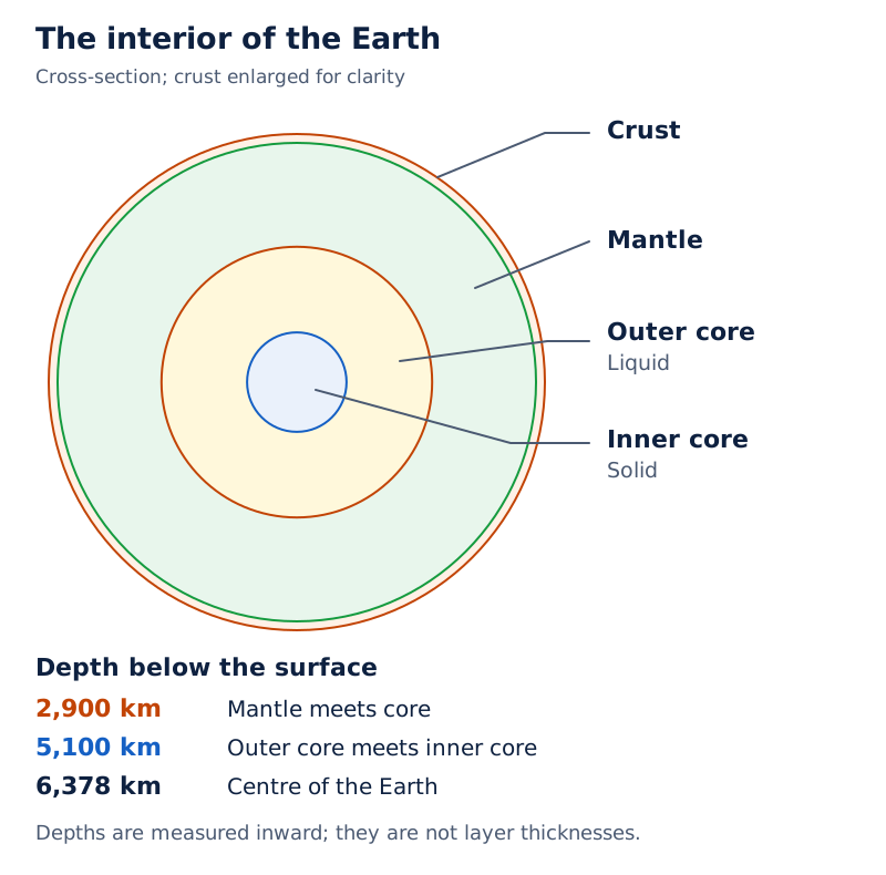
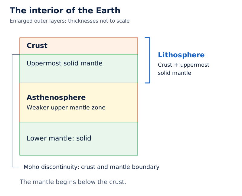
The wedge-shaped section labels crust, lithosphere, asthenosphere, mantle and core. The core is divided into liquid and solid portions. Depth labels include 2,900 km, 5,100 km and 6,378 km.
Drawn by One Young India.
The diagram places the inner core below the 5,100 km depth label, with the centre at 6,378 km. These are depths measured inward, not separate layer thicknesses. A labelled section should preserve that distinction.
How do scientists learn about the Earth's interior?
Most knowledge of the Earth's interior is largely based on estimates and inferences. Direct evidence includes accessible rock samples from the surface, mines and drilling. Erupted material can also be analysed, although it is difficult to ascertain the depth from which its magma came.
Indirect evidence includes earthquake waves, gravity, magnetic properties and comparisons with material from meteors. Meteor material is not a sample collected from inside the Earth. Its usefulness comes from similarities between its materials and those making up our planet.
What do earthquake waves reveal?
Seismic waves are vibrations generated by the release of earthquake energy. A seismograph records these waves. Their speed and direction change as they pass through different materials, providing clues about the layers they encounter.
Body waves travel through the Earth's interior. P-waves, or primary waves, travel faster and pass through solids, liquids and gases. S-waves, or secondary waves, arrive later and travel only through solids. The letters identify wave types, not mathematical quantities.
Surface waves travel along the surface after body waves interact with surface rocks. They are considered the most damaging waves. Reflection means a wave rebounds; refraction means its direction changes on passing through different materials.
Note: A liquid outer core does not mean that the whole interior is liquid. The lower mantle and inner core are solid. The different behaviour of P-waves and S-waves helps distinguish these internal conditions.
A shadow zone is an area where particular earthquake waves are not recorded. Such patterns support deductions about internal structure. Scientists combine wave records with other evidence because direct access reaches only a small part of the Earth.
How do fold, block and residual mountains form?
A landform is a distinct part of the Earth's surface with its own shape and materials. Related landforms together form a landscape. A mountain is a natural elevation rising prominently above its surroundings, usually with steep slopes and a relatively small summit area.
Endogenic forces originate within the Earth. They can build up or displace its crust. Exogenic forces operate at the surface and wear down or redistribute material. Mountain form reflects both construction by internal movements and later changes at the surface.
What distinguishes the three mountain types?
| Type | Formation | Examples |
|---|---|---|
| Fold mountain | Compression, or squeezing pressure, bends rock layers into folds and builds mountain belts | Himalayas in Asia; Alps in Europe |
| Block mountain | Movement along fractures leaves a block standing higher than adjacent blocks | Satpura in India; Vosges in Europe |
| Residual mountain | Wearing away removes less resistant material and leaves resistant uplands | Aravalli in India; Scottish Highlands in Europe |
Compression is squeezing pressure. Folding bends rock layers, whereas faulting involves movement along a fracture in rock. A raised or relatively higher fault block is called a horst; a lowered block is a graben.
Residual mountains are also called mountains of denudation. Denudation is the collective stripping and wearing down of the land through weathering, mass movement (gravity-driven downslope motion), erosion (removal and transport by natural agents) and transport. The surviving high ground reflects differences in resistance to these processes.
Case study: Why are the Himalayas prone to landslides?
The Himalayas combine crustal movements with active surface processes. Their continental crust is as much as 70 km thick. They are tectonically active, meaning that movements and deformation of the Earth's crust continue there.
Landslides are relatively rapid downslope movements of rock or debris. Himalayan slopes are steep, and most of their material consists of sedimentary rocks, formed from deposits, and material that is loose or partly consolidated. These conditions help explain frequent landslides and debris avalanches, rapid flows of loose material down slopes.
The Nilgiris and Western Ghats are relatively tectonically stable and mostly consist of very hard rocks. Landslides still occur, though less frequently than in the Himalayas: steep slopes, mechanical weathering (physical rock breakdown) and heavy rain over short periods also matter.
How do plateaus and plains differ in origin?
A plateau is an elevated area with a comparatively level surface. A plain is a broad area of relatively low relief, meaning small differences in surface height. Height alone does not explain either landform: its position, structure and formation also matter.
What are intermont and volcanic plateaus?
An intermont plateau lies between surrounding mountain ranges. It can form when extensive land is uplifted during mountain building. The Tibetan Plateau is a world example, while Ladakh provides an Indian example of high plateau country among mountains.
A volcanic plateau develops through successive lava outpourings that cool and accumulate. Lava is molten rock moving towards or reaching the surface. Repeated spreading flows can build an extensive elevated surface rather than a single steep volcanic cone.
Case study: What do the Deccan Traps show?
The Deccan Traps are an Indian flood basalt province covering most of the Maharashtra plateau. Basalt is a volcanic rock; flood basalt eruptions release highly fluid lava that can spread over long distances. Such provinces may contain successive flows.
Some flood basalt flows attain thicknesses of more than 50 metres and individual flows may extend hundreds of kilometres. These are general features of flood basalt provinces, not measurements assigned to every Deccan flow. It is believed that the Deccan formations originally covered a much larger area.
What are structural and depositional plains?
Structural plains develop where broad areas of comparatively undisturbed, nearly horizontal rock layers are exposed, including through emergence or uplift. The Russian Platform provides an example. Their broad level character relates to the underlying arrangement of rocks.
Depositional plains grow through the accumulation of transported material. River deposits are called alluvium. The Ganga Plain in India and the Mississippi Plain are examples. Rivers can spread fine sediment across neighbouring land when they overflow their banks.
Note: A volcanic plateau is built by lava accumulation; an intermont plateau is identified by its position among mountains. A depositional plain is built from transported sediment. Similar-looking level surfaces can therefore have different origins.
How do rocks form and change through the rock cycle?
Rocks contain minerals and vary in colour, grain size and texture. The three main rock groups are distinguished by formation: igneous rocks form by cooling molten material, sedimentary rocks form from accumulated deposits, and metamorphic rocks result from alteration by heat and pressure.
| Rock group | Formation and characteristic | Example |
|---|---|---|
| Intrusive igneous | Slow cooling inside the crust produces large grains | Granite |
| Extrusive igneous | Rapid cooling at the surface produces very fine grains | Basalt |
| Sedimentary | Deposits are compressed and hardened into layers | Sandstone, formed from sand grains |
| Metamorphic | Existing rock changes under great heat and pressure | Marble, formed from limestone |
Sediments are particles produced by rock breakdown and carried or deposited by agents such as water and wind. Sedimentary rocks may contain fossils, preserved remains of past plants and animals. “May contain” does not mean every specimen contains visible fossils.
What links the rock groups?
The rock cycle is the transformation of one rock type into another under changing conditions. Cooling, breakdown, transport, deposition, alteration and melting connect its parts. Melting produces magma; cooling that magma produces igneous rock again.
- Molten material cools and solidifies into igneous rock.
- Rock breaks into particles that agents transport and deposit.
- Deposits become compressed and hardened into sedimentary rock.
- Great heat and pressure can change existing rock into metamorphic rock.
- Melting returns rock material to magma, which can cool again.
What are volcanoes, and where do they occur?
A volcano is a place where gases, ash and molten rock escape to the surface. A vent is the opening through which material emerges. Volcanic eruptions connect processes inside the Earth with the construction and destruction of surface features.
How are volcanoes classified by activity?
- Active: materials are being released or have been released in the recent past.
- Dormant: a volcano has been quiet for a long period but may erupt again.
- Extinct: a volcano is considered unlikely to erupt again because its volcanic activity has ceased.
This classification concerns activity. Classification by shape and eruption style answers a different question. Shield volcanoes have broad, gentle slopes because their mostly basaltic lava is very fluid. Hawaiian volcanoes are well-known examples.
Composite volcanoes build layers of lava and fragmented volcanic material around their vents. Their cooler, more viscous lava flows less easily than basaltic lava, and eruptions often become explosive. “Often” allows variation; it does not mean that every eruption is explosive.
What are constructive and destructive effects?
Constructive effects build land and resources: lava creates new rock and volcanic landforms, and lava plateaus often have rich black soil. Destructive effects include damage to settlements, vegetation and farmland by lava, ash and other erupted material.
A caldera is a depression formed when an extremely explosive volcano collapses into itself. Such volcanoes are usually so explosive that they tend to collapse rather than construct a tall mountain. Volcanic activity therefore does not invariably increase the height of the land.
What the figure shows
Volcanic zones of the world
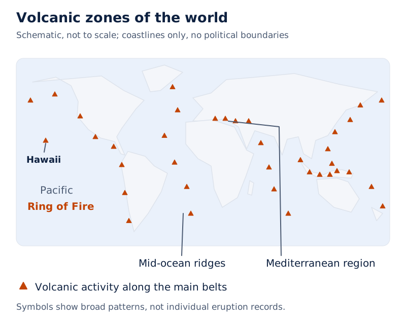
Volcanic-eruption symbols follow much of the Pacific rim, labelled “Ring of Fire”. Other symbols occur along oceanic ridges and in the Mediterranean region. Hawaii is labelled within the Pacific, away from its rim.
Drawn by One Young India.
The main volcanic belts include the Circum-Pacific belt, meaning the belt around the Pacific, the Mediterranean region, and mid-ocean ridges. A mid-ocean ridge is a submerged mountain chain with volcanic activity along its central zone.
Why do earthquakes occur, and how are they measured?
An earthquake is shaking caused by a sudden release of energy within the Earth. The focus, also called the hypocentre, is the point where energy is released. The epicentre is the point on the surface directly above it.
How does movement along a fault cause shaking?
- Rock blocks on opposite sides of a fault tend to move relative to one another.
- Friction can lock the blocks together while forces continue to act.
- The rocks deform until the tendency to move overcomes the friction.
- The blocks slide abruptly, releasing energy that travels outward as seismic waves.
Tectonic earthquakes, produced by rock movement along faults, are the most common type. Earthquakes associated with active volcanoes form another group. Mine-roof collapses, explosions and large reservoirs can also cause tremors; a tremor is a shaking movement of the ground.
Magnitude describes the energy released; the Richter scale expresses it numerically. Intensity describes observed effects and damage; the Mercalli scale has twelve levels. A seismograph is the recording instrument, while a scale provides a way to express an earthquake's size or effects.
Here, angular distance measures separation around the Earth as an angle at its centre. A degree is a unit of angle. The shadow-zone pattern helps explain the layered interior; it is not a scale of earthquake damage.
| Earthquake-wave observation | Angular distance from epicentre | Recorded pattern |
|---|---|---|
| Nearer recording stations | Within 105 degrees | Both P-waves and S-waves arrive |
| Common shadow band | Between 105 and 145 degrees | Neither direct P-waves nor S-waves are recorded in this band |
| Farther recording stations | Beyond 145 degrees | P-waves arrive, but S-waves do not |
What effects and distribution patterns matter?
Destructive effects include shaking, building collapse, landslides, fires, falling objects and floods following dam failure. Tsunamis are sea waves generated by disturbances such as undersea earthquakes. For an earthquake-generated tsunami, the epicentre must be below oceanic waters and the magnitude sufficiently high.
Earth movements can also raise or lower land and alter drainage. Newly uplifted land and depressions that collect water are sometimes described as constructive effects. These outcomes do not make an earthquake beneficial overall: destruction of life and property can remain severe.
What the figure shows
Earthquake zones of the world
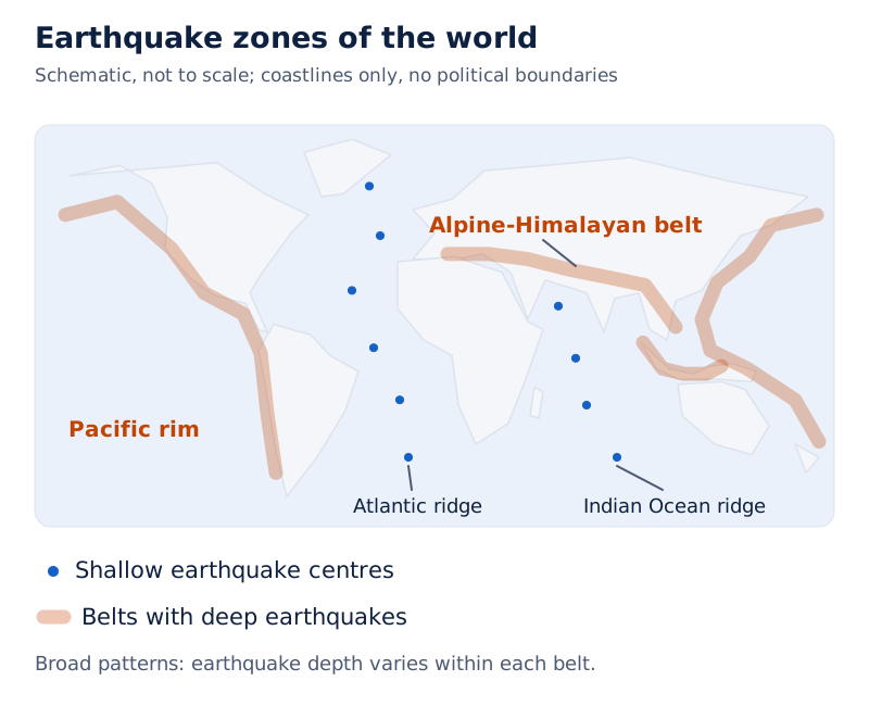
The map distinguishes shallow earthquake centres from shaded deep-earthquake zones. Centres trace the Atlantic and Indian Ocean ridges; shaded belts occur around the Pacific and along the Alpine-Himalayan system.
Drawn by One Young India.
In general, earthquake foci along mid-ocean ridges are shallow, while deep-seated earthquakes occur along the Alpine-Himalayan belt and Pacific rim. These are broad distribution patterns. They should not be turned into a claim that every earthquake in either belt has the same depth.
How does physical weathering break rocks apart?
Weathering is the mechanical disintegration and chemical decomposition of rock through weather and climate. Disintegration means breaking into pieces; decomposition means chemical alteration. Weathering is mainly an in-situ, or on-site, process, with very little or no movement of material.
Physical weathering breaks rock without changing its chemical composition. Temperature changes cause expansion and contraction. Removal of overlying material releases pressure. Repeated stresses can gradually weaken rock even when the change during one heating or cooling cycle is small.
How do blocks, grains and sheets separate?
| Form of breakdown | Meaning | Explanation |
|---|---|---|
| Block disintegration | Rock splits into blocks along cracks or joints | Repeated stresses widen existing weaknesses |
| Granular disintegration | Individual mineral grains loosen and separate | Different minerals respond differently to heating and cooling |
| Exfoliation | Curved outer sheets or shells peel from rock | Expansion and contraction, or pressure release, can produce peeling |
A joint is a crack in rock without appreciable displacement along it. Block disintegration separates larger pieces along such weaknesses. Granular disintegration loosens the grains making up the rock. These describe different sizes and patterns of breakdown.
Exfoliation is a result of weathering, rather than an independent driving force. Its peeling layers can leave smooth, rounded surfaces. Exfoliation domes are associated with unloading, meaning removal of weight above rock; temperature-driven expansion can also produce exfoliation.
Diagram
Physical weathering patterns
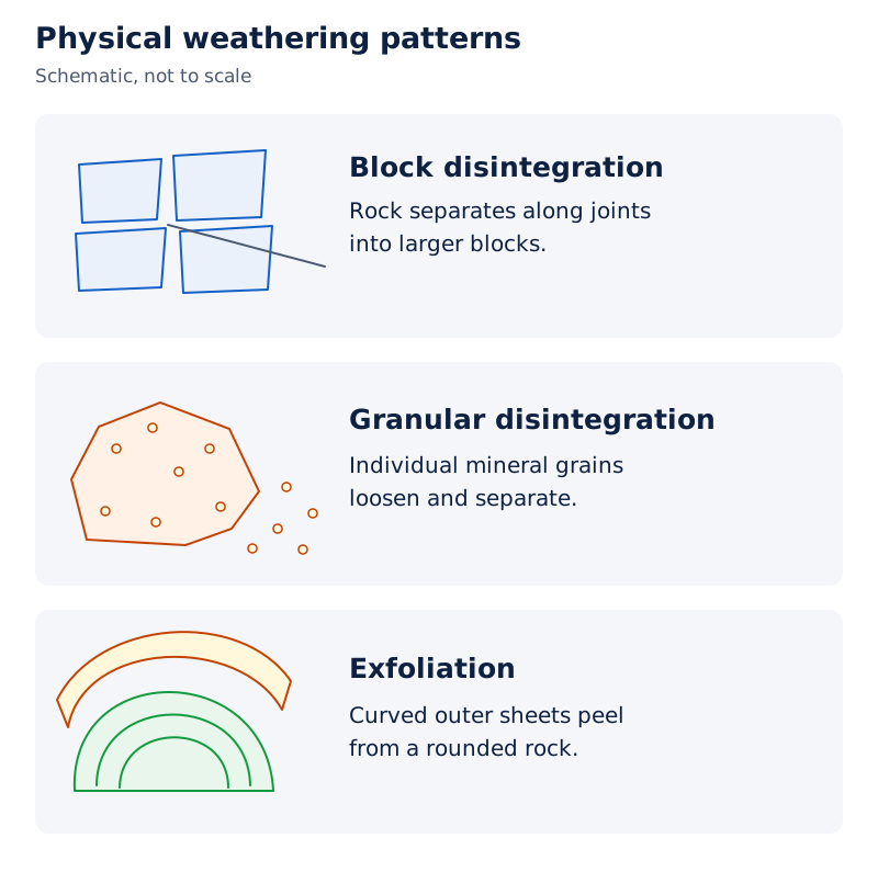
Draw separate sketches of a jointed rock splitting into blocks, a rock shedding grains, and curved sheets peeling from a rounded rock. Label each sketch with the corresponding form of breakdown.
Drawn by One Young India.
Most physical weathering is caused by thermal expansion and pressure release. Climate, rock structure and repeated stress influence its operation. Physical, chemical and biological weathering very rarely operate completely independently, although one may dominate in particular conditions.
How do chemical and biological weathering change rocks?
Chemical weathering alters rock minerals through reactions involving water, oxygen, carbon dioxide and acids. Heat and moisture influence reaction rates. Dissolved substances can be removed, while altered minerals may become weaker or more easily broken down.
What are the four named chemical processes?
| Process | What happens? | Result or example |
|---|---|---|
| Oxidation | Oxygen reacts with minerals, especially those containing iron | Oxides form and the affected rock may weaken |
| Carbonation | Carbon dioxide dissolves in water to form weak carbonic acid | The acidic water acts on carbonate rocks such as limestone |
| Hydration | A mineral takes water into its chemical structure | Changes in volume can place stress on surrounding material |
| Solution | Water dissolves soluble minerals | Dissolved material is removed in water |
Carbonates are minerals containing the carbonate chemical group; limestone is rich in calcium carbonate. Carbonation describes a chemical reaction involving carbon dioxide. Solution describes dissolving. These processes can work together, so their effects need not occur separately.
Carbon dioxide comes from the air and from decomposition of plant and animal matter underground. Water and air, along with heat, speed chemical reactions. Chemical weathering is therefore linked to the conditions surrounding the rock as well as to its mineral composition.
How do plants, animals and humans contribute?
Biological weathering involves organisms changing earth material physically or affecting its minerals chemically. Plant roots exert pressure as they grow, breaking material apart. Roots are therefore a biological cause of mechanical breakdown.
Burrowing animals, including earthworms and rodents, expose fresh surfaces and let moisture and air penetrate. Decaying organisms produce acids that enhance decomposition and increase the solubility of some materials. Solubility is the capacity of a substance to dissolve in a liquid.
Humans contribute by disturbing vegetation, ploughing and cultivating soil. These activities mix material and create new contacts between air, water and minerals. Biological action therefore connects physical disruption with chemical change rather than forming a wholly separate pathway.
Weathering prepares material for soil formation and assists erosion and downslope movement. It can also concentrate useful mineral deposits when other constituents are removed. This concentration of remaining valuable material is called enrichment.
How does denudation reshape the land?
Denudation includes weathering, mass movement, erosion and transportation. Mass movement transfers rock or debris downslope under gravity. Erosion involves agents removing and transporting material. Deposition occurs when carried material settles, commonly as the transporting agent loses speed and energy.
The agents of erosion include running water, groundwater, glaciers, wind and waves. Groundwater is water beneath the surface, while a glacier is a moving body of ice. Each agent works differently, depending on its motion and the materials it encounters.
Why must the processes be distinguished?
Weathering weakens and breaks rock mostly where it lies. A river can then remove the fragments and carry them downstream. When they settle, deposition builds a new accumulation. These connected actions describe preparation, removal, movement and settling, rather than a single interchangeable process.
In mass movement, gravity moves the debris directly; wind, flowing water or ice does not carry it as an agent. Weathering can assist this movement, but it is not a necessary precondition. Unweathered rock can also fall or slide.
Weathering and erosion help lower relief, the variation in land height. Deposition fills depressions. Rock resistance, slope and climate affect the rate of change, so different areas do not necessarily become level at the same rate.
Definition: A geomorphic agent is a mobile natural medium capable of acquiring, transporting and depositing earth material. Running water and wind are agents; erosion and deposition describe actions associated with their movement.
How do rivers form valleys, waterfalls, meanders and deltas?
Running water cuts into and transports material from the land. A river's gradient is the steepness of its course. Steeper gradients commonly favour downward cutting; gentler gradients allow more lateral erosion, meaning sideways erosion of the banks, and deposition.
How do the stages of a river landscape differ?
| Stage | Typical activity | Associated features |
|---|---|---|
| Youth or upper-course conditions | Downward cutting is prominent on steeper slopes | V-shaped valleys; waterfalls and rapids may occur |
| Maturity or middle-course conditions | Sideways erosion becomes more important | Wider valley floors, floodplains and meanders |
| Old age or lower-course conditions | Streams cross broad areas with gentle gradients | Extensive floodplains and freely developing meanders |
These stages describe characteristic developments rather than a fixed age in years. A floodplain is land built from river deposits, including material spread during floods. A delta can develop at a river mouth when sediment accumulates faster than it is removed.
How are valleys and waterfalls produced?
A V-shaped valley has sides that slope towards a relatively narrow river bed. Small channels deepen and widen as erosion continues. Downward cutting, combined with the lowering of the valley sides, produces the recognisable cross-section.
A waterfall is a steep descent of water over a rocky step or valley side. Where resistant rock overlies softer rock, erosion undercuts the softer material. Falling water and rotating rock fragments can excavate a plunge pool, a deep hollow at the waterfall's foot.
How do meanders and deltas develop?
Meanders are looping bends in a river's channel. Normally, erosion acts on the outer, concave bank, while deposition occurs along the inner, convex bank. Concave means curving inward; convex means bulging outward. Meanders are channel patterns shaped by both processes.
- A river flowing over a gentle gradient starts working sideways against its banks.
- Small bank irregularities develop into bends through erosion outside and deposition inside.
- The bends enlarge into deeper loops as these processes continue.
- A loop may become cut off, leaving an oxbow lake, an abandoned curved section of the river channel filled with water.
What the figure shows
Meander growth and cut-off loops
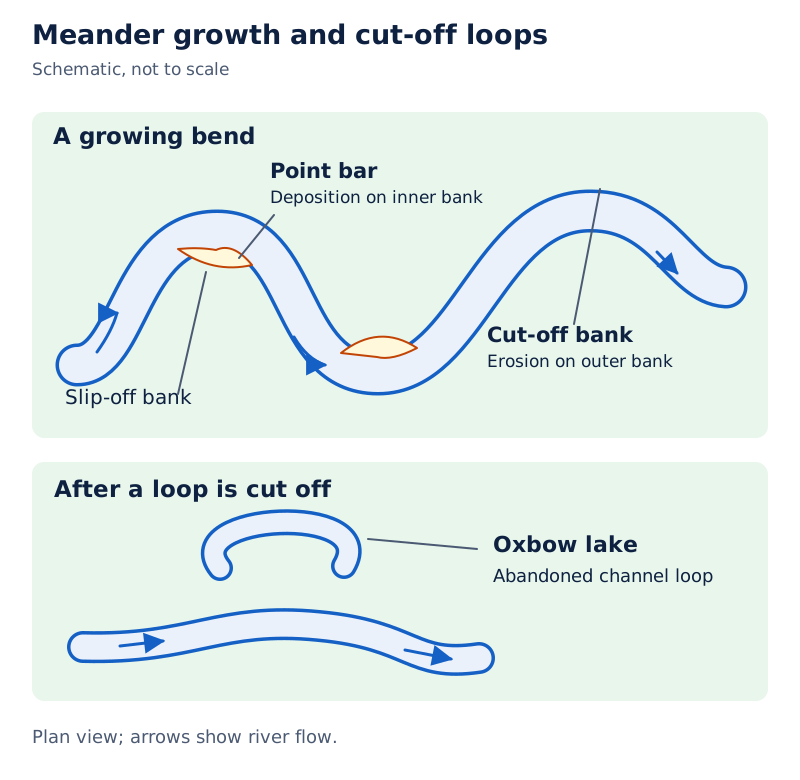
The drawing shows a winding channel with flow arrows, point bars, slip-off banks, a cut-off bank and an oxbow lake. Point bars are sediment accumulations on the inside of bends.
Drawn by One Young India.
A delta is an accumulation of river sediment at the mouth. Coarser particles settle first, while finer silt and clay travel farther. If the load is not carried far away or redistributed along the coast, deposits grow outward into the sea.
Distributaries are branches carrying water away from the main river across the depositing area. As the delta builds outward, these channels lengthen. Delta formation depends on sediment supply and removal, so reaching the sea does not guarantee that a river forms a delta.
How does wind form deflation hollows and sand dunes?
Wind can remove, transport and deposit loose material. Its action is especially visible in dry, bare areas with available sediment. Deflation is the lifting and removal of dust and smaller particles; abrasion is the wearing of surfaces by particles striking or rubbing against them.
What distinguishes erosion from deposition by wind?
Persistent wind can remove loose soil or weathered material and create a shallow depression called a deflation hollow. This is an erosional feature because material has been taken away. Deflation can also produce small cavities on exposed surfaces.
Sand dunes are accumulations of wind-deposited sand. Obstacles help start dune formation. When wind slows, particles begin to settle according to their size and the wind's ability to carry them. Wind deposits commonly show sorting, meaning separation into different grain sizes.
A barchan is a crescent-shaped dune whose horns point downwind, in the direction the wind travels. Barchans form where wind direction is constant and moderate and the original surface is almost uniform. Dune shape therefore carries information about its forming conditions.
Longitudinal dunes extend along the wind direction; transverse dunes extend across it. A seif resembles a barchan with one wing, while parabolic dunes have a reversed crescent form associated with partially vegetated sandy surfaces.
What the figure shows
Sand dune forms
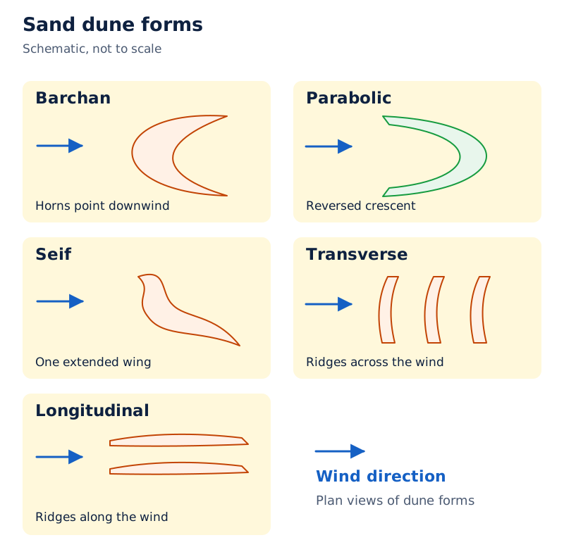
The diagram labels barchan, seif, parabolic, transverse and longitudinal dunes. Arrows indicate wind direction. Barchans are drawn as crescents, while longitudinal dunes appear as long ridges.
Drawn by One Young India.
Most desert dunes shift, while a few become stabilised, especially near human habitation. Wind is not the sole agent shaping deserts. Rain may be scarce yet torrential, and running water and broad surface flows can remove weathered material as well.
Glossary
- Crust — The brittle, outermost solid layer of the Earth, thinner beneath oceans than beneath continents.
- Mantle — The layer beneath the crust, extending down to the core boundary at 2,900 kilometres.
- Core — The innermost layer, composed mostly of nickel and iron, with liquid outer and solid inner portions.
- Lithosphere — The outer part of the Earth comprising its crust and uppermost solid mantle.
- Asthenosphere — A weaker upper mantle zone that provides the main source of magma for volcanic eruptions.
- Fault — A fracture in rock along which blocks have moved relative to one another.
- Focus — The point within the Earth where earthquake energy is released, also called the hypocentre.
- Epicentre — The point on the Earth's surface situated directly above the focus of an earthquake.
- Rock cycle — The transformation of rock types through processes including cooling, breakdown, deposition, alteration and melting.
- Weathering — Mechanical disintegration and chemical decomposition of rocks through weather and climate, with very little or no movement.
- Denudation — The collective stripping of the land through weathering, mass movement, erosion and transportation.
- Meander — A looping bend in a river channel, shaped through bank erosion and sediment deposition.
- Delta — An accumulation of river deposits at a mouth where sediment is not carried away.
- Deflation — The lifting and removal of loose dust and smaller particles by the wind.
- Exfoliation — The peeling of curved outer sheets or shells from rock, leaving a more rounded surface.
Common errors and misconceptions
- Misconception: The crust and lithosphere are identical. Correct: The lithosphere includes the crust and the uppermost solid mantle.
- Misconception: The whole mantle and core are liquid. Correct: The lower mantle is solid; the outer core is liquid and the inner core is solid.
- Misconception: The focus lies on the Earth's surface. Correct: Energy is released at the focus within the Earth; the epicentre lies directly above it at the surface.
- Misconception: A seismograph and the Richter scale are the same thing. Correct: One is a recording instrument; the other expresses earthquake magnitude.
- Misconception: Every quiet volcano is extinct. Correct: A dormant volcano has been quiet but may erupt again.
- Misconception: Weathering necessarily transports fragments downstream. Correct: Weathering involves very little or no movement; erosion includes removal and transport by agents.
- Misconception: All sedimentary rocks contain visible fossils. Correct: Sedimentary rocks may contain fossils, but their defining feature is their formation from deposits.
- Misconception: Meanders form through erosion alone. Correct: Normally, outer-bank erosion and inner-bank deposition work together to enlarge river bends.
Exam-style questions with model answers
Q1. The crust is the outermost solid layer; the lithosphere includes the crust and uppermost solid mantle. The outer core is liquid and the inner core is solid. State the difference between crust and lithosphere, and the difference between the two parts of the core. [2 marks]
- The lithosphere has a greater extent than the crust because it includes the uppermost solid mantle as well as the crust.
- The core differs in physical state: its outer part is liquid, whereas its inner part is solid.
Q2. Oceanic crust has a mean thickness of 5 kilometres; continental crust is around 30 kilometres thick; Himalayan crust is as much as 70 kilometres thick. Give three comparisons, preserving the qualifications attached to the values. [3 marks]
- Oceanic crust is thinner than continental crust: its mean thickness is 5 kilometres, compared with around 30 kilometres for continental crust.
- Himalayan crust, at as much as 70 kilometres, is thicker than the general continental value of around 30 kilometres.
- The Himalayan example shows variation within continental crust: the general value is approximate, while the Himalayan statement indicates how thick it can be.
Q3. Igneous rocks form when molten material cools. Rock fragments can be transported, deposited, compressed and hardened into sedimentary rocks. Heat and pressure can form metamorphic rocks; melting returns rock to magma. Use these facts to explain four linked parts of the rock cycle. [4 marks]
- Cooling begins the stated sequence: molten material becomes solid, producing igneous rock rather than remaining as magma.
- Breakdown supplies fragments that are transported and deposited; compression and hardening turn the accumulated sediment into sedimentary rock.
- Heat and pressure can alter existing rock into metamorphic rock, connecting another rock group to the sequence.
- Melting changes rock back into magma. This can cool again, linking the end of the described sequence to its beginning.
Q4. Rock blocks along a fault tend to move, but friction can lock them. Continued force deforms them until they slide abruptly and release energy as seismic waves. The focus is the energy-release point; the epicentre is directly above it at the surface; a seismograph records waves. Explain the event in five points, including the two locations and the recording instrument. [5 marks]
- The fault separates rock blocks that tend to move relative to one another. Friction initially prevents their free movement and holds them together.
- Continued force deforms the locked rocks. The tendency to move eventually overcomes friction, allowing the blocks to slide abruptly along the fault.
- The sudden movement releases energy. Seismic waves carry this energy outward, producing the shaking associated with the earthquake rather than leaving the disturbance confined to the fault.
- The focus identifies the point where energy is released inside the Earth. The epicentre identifies the surface position directly above that point.
- A seismograph records the arriving waves. Its record provides evidence of the event, while focus and epicentre describe locations rather than instruments.
Q5. In physical weathering, repeated expansion and contraction break rock without changing its composition. Chemical weathering changes minerals through reactions with water, oxygen or acids. Growing roots split rock, and decay of organisms produces acids. Explain physical, chemical and biological contributions in three separate points. [3 marks]
- Physical weathering breaks rock into smaller pieces through repeated expansion and contraction. The material changes in size, while its chemical composition remains unchanged.
- Chemical weathering alters the minerals themselves through reactions involving water, oxygen or acids, rather than simply separating pieces of the original material.
- Biological contributions include root pressure that splits rock and acids produced during decay. Organisms therefore contribute to both mechanical breakdown and chemical change.
Q6. Compression folds layers to form fold mountains. Movement along fractures forms block mountains. Removal of weaker rock leaves resistant residual mountains. Successive lava flows build volcanic plateaus. Explain the origin of each of these four landform types from the information given. [4 marks]
- Fold mountains arise when compression bends rock layers. Their origin is therefore linked to bending of the layers into folds.
- Block mountains form through displacement along fractures, leaving blocks at different levels rather than requiring the layers to fold.
- Residual mountains remain after weaker material is removed. Their surviving high ground consists of material that resists wearing away more effectively.
- Volcanic plateaus grow through successive lava flows. Accumulation builds an elevated surface, so their origin differs from folding, fault displacement or residual survival.
Q7. On gentle slopes, rivers erode sideways. Normally, a meander's outer bank is eroded and its inner bank receives sediment; growing loops may become cut off as oxbow lakes. At the sea, retained river sediment accumulates into a delta, with coarser particles settling before finer ones. Explain these developments in five points without assuming every river mouth forms a delta. [5 marks]
- A gentle slope allows a river to work sideways against its banks. This lateral erosion helps the channel develop bends instead of cutting predominantly downward.
- Normally, erosion removes material from the outside of a meander. The growing bend therefore changes position as its outer bank is worn back.
- Deposition adds sediment to the inside of the bend. It works with outer-bank erosion, so the development of a meander involves both removal and accumulation.
- As loops enlarge, a loop may become cut off from the main river. The abandoned, water-filled bend then forms an oxbow lake.
- A delta develops when sediment accumulates at the mouth rather than being removed. Coarser particles settle first; finer material travels farther, so reaching the sea alone does not ensure delta formation.
Q8. Persistent wind removes loose particles to produce a deflation hollow. Sand settles into dunes when wind loses the ability to carry it. Identify which feature is erosional and which is depositional, giving the reason for each. [2 marks]
- A deflation hollow is erosional because wind removes loose particles and leaves a depression in the surface.
- A sand dune is depositional because transported sand settles and accumulates when the wind can no longer carry it.
Key takeaways
- The crust, mantle and core differ in composition and state; the lithosphere includes both crust and uppermost solid mantle.
- Fold mountains, block mountains and residual mountains originate through folding, fault displacement and selective wearing away respectively.
- Intermont plateaus lie among mountains, volcanic plateaus accumulate lava, and depositional plains accumulate transported sediment.
- Cooling, rock breakdown, deposition, heat, pressure and melting connect the major rock groups within the rock cycle.
- Volcanoes can build new land while eruptions destroy existing surfaces; quiet conditions alone do not establish extinction.
- Earthquake magnitude concerns released energy, intensity concerns observed effects, and a seismograph is the instrument recording waves.
- Weathering occurs with very little or no movement; erosion removes material, and deposition builds accumulations elsewhere.
- Rivers shape valleys, waterfalls, meanders and deltas, while wind erosion and deposition produce deflation hollows and dunes.
Test yourself
Which parts of the core are liquid and solid?
The outer core is liquid, whereas the inner core is solid.
Why can S-waves help reveal the Earth's internal structure?
S-waves travel only through solids, so their absence from particular paths helps identify liquid material inside the Earth.
What distinguishes a residual mountain from a fold mountain?
A residual mountain survives wearing away of surrounding weaker material; a fold mountain forms when compression bends rock layers.
What is the difference between intrusive and extrusive igneous rock?
Intrusive rock cools slowly within the crust and develops larger grains; extrusive rock cools rapidly at the surface and is very fine-grained.
Why does a dormant volcano require a different description from an extinct one?
A dormant volcano may erupt again after a quiet interval; an extinct volcano is considered unlikely to resume eruption.
How can plant roots contribute to weathering?
Growing roots exert pressure on earth material, mechanically breaking it apart and contributing to biological weathering.
Where do erosion and deposition normally occur in a meander?
Erosion normally occurs along the outer, concave bank, while deposition occurs along the inner, convex bank.
How is a deflation hollow different from a sand dune?
A hollow results from wind removing loose particles; a dune results from wind-transported sand accumulating.
Write about it
Turn a question from this chapter into a paper.
The Writing Studio has a structure guide, a rubric and citation tools for 15 formats, from essays to research papers. Drafting is free with an account. Learnacy Essential adds feedback from an AI writing coach and submission to The OYI Review.
Learnacy Essential is ₹1,499 for the year. Publication depends on review and is not guaranteed.