
Lifelines of National Economy | CBSE Class 10 Geography Notes
On this page
Try an idea before you read. Every good needs the right transport. Choose the most suitable — and cheapest — mode for each job. Explore →
This note covers transport and communication as economic lifelines, road categories, railway distribution, pipelines, inland waterways, major sea ports, air transport, postal and mass communication, international trade, the balance of trade, and tourism.
Why are transport and communication called economic lifelines?
Transport moves goods and people between places. Materials needed in daily life are not all available nearby. Goods must travel from places supplying them to places where people need them. Traders help bring products to consumers through transportation.
Development therefore depends on both production and movement. Producing goods and services is insufficient if they cannot reach users. Efficient transport is a prerequisite for rapid development because it connects the places where economic activities occur.
How do the three systems work together?
Communication allows information to pass between people and places. Trade is the exchange of goods among people, states and countries. Transport, communication and trade are complementary: each supports the working of the others.
- Goods and services are produced in supply locations, while demand may arise in other places.
- Traders facilitate their movement towards consumers, linking production with the places where goods are required.
- Transport carries goods across space, while developed communication supports these wider connections.
- Together, efficient transport and communication networks support trade at local, national and global levels.
Science and technology have extended the area served by transport and trade. Fast transport, supported by communication, has brought distant places closer in practical terms. India's vast size and linguistic and socio-cultural diversity have not prevented its connections with the rest of the world.
What are the main transport domains?
Transport operates over land, water and air. Land transport includes roads, railways and pipelines. Water transport includes inland and overseas movement. Air transport connects places within the country and across national boundaries.
What the figure shows
Classification of transport
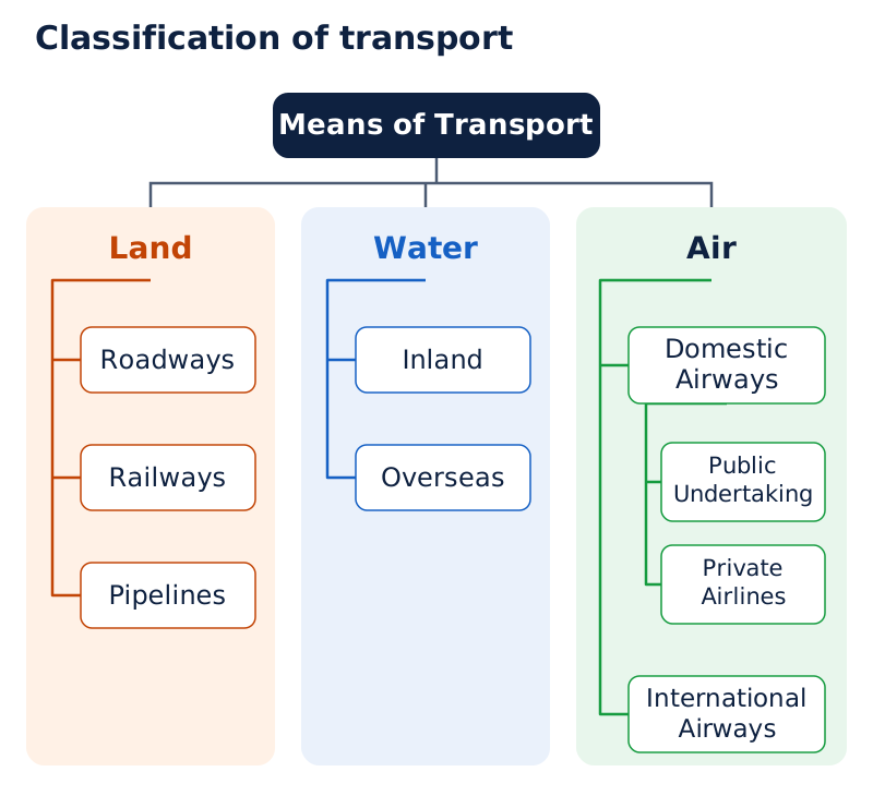
The chart branches from “Means of Transport” into Land, Water and Air. Land divides into Roadways, Railways and Pipelines; Water into Inland and Overseas; Air into Domestic Airways and International Airways. Public Undertaking and Private Airlines appear below Domestic Airways.
Drawn by One Young India. See Fig. 7.1 in your NCERT textbook
Railways, airways, waterways, newspapers, radio, television, cinema and the internet contribute to socio-economic progress. Trade from local to international levels adds vitality to the economy and supports the facilities and amenities used in everyday life.
Why do roadways have advantages over railways?
India's road network was the world's second largest, extending to about 62.16 lakh kilometres in 2020 to 2021. A kilometre, written as km, is a unit of distance. Roadways developed before railways in India and retain advantages because they are comparatively easy to build and maintain.
How do costs, terrain and distance matter?
The construction cost of roads is much lower than that of railway lines. Roads can cross comparatively more dissected and undulating land, meaning land broken by valleys and uneven slopes. They can also negotiate steeper gradients, or slopes, including mountainous areas such as the Himalayas.
Road transport is economical for a few people and relatively small quantities of goods over short distances. This qualification matters: its advantage here concerns the number of travellers, the quantity carried and the distance covered.
| Advantage | Reason it matters |
|---|---|
| Lower construction cost | Building roads costs much less than laying railway lines. |
| Greater flexibility across uneven land | Roads can cross comparatively more dissected terrain and negotiate higher gradients. |
| Economy over short distances | A few people or relatively small quantities of goods can be carried economically. |
| Door-to-door service | Direct delivery reduces loading and unloading costs. |
| Feeder role | Roads connect users with railway stations, airports and sea ports. |
Why are roads also feeders?
A feeder provides a link to another transport mode. Roads connect railway stations, airports and sea ports with other places. Their importance therefore includes both journeys made entirely by road and journeys in which road transport supports another mode.
Door-to-door service means carrying people or goods directly between their starting point and destination. It lowers the costs associated with loading and unloading. This helps explain why roads remain useful even where railways and other transport systems operate.
The advantages of roads should be understood together: construction, access across uneven terrain, short-distance economy and connections with other modes all contribute to their growing importance.
How are roads classified and how do border roads improve access?
Roads are classified into six classes according to capacity. Their functions range from connecting major cities and distant parts of the country to linking villages, district headquarters and border areas. Construction material provides another basis of classification.
Which places do the six road classes connect?
| Road class | Connections and purpose |
|---|---|
| Golden Quadrilateral Super Highways | Six-lane links connect Delhi, Kolkata, Chennai, Mumbai and Delhi; the project also includes the North-South and East-West corridors. |
| National Highways | The primary road system links extreme parts of the country; a number of major routes run north-south and east-west. |
| State Highways | These link a state capital with different district headquarters. |
| District Roads | These connect district headquarters with other places in the district. |
| Other Roads | Rural roads link villages and rural areas with towns. |
| Border Roads | These serve bordering areas and improve access across difficult terrain. |
The North-South Corridor links Srinagar and Kanniyakumari. The East-West Corridor links Silchar in Assam and Porbander in Gujarat. The Super Highway project's main objective is to reduce the time and distance between mega cities.
The National Highway Authority of India (NHAI) implements these highway projects. The Pradhan Mantri Grameen Sadak Yojana gives rural roads special support, with provisions to link every village to a major town by an all-season motorable road.
What the figure shows
National Highways
The map distinguishes the North-South corridor, East-West corridor and Golden Quadrilateral in its key. Trace Srinagar to Kanniyakumari, Silchar to Porbander, and the links among Delhi, Kolkata, Chennai and Mumbai. Numbered boxes identify National Highways.
Reference: NCERT Class 10, page 73
Case study: How does the Atal Tunnel improve connectivity?
The Border Roads Organisation, established in 1960, constructs and maintains strategically important roads in northern and north-eastern border areas. These roads have improved accessibility in difficult terrain and supported economic development.
The organisation built the 9.02 km Atal Tunnel in the Pir Panjal range of the Himalayas. It connects Manali with the Lahul-Spiti valley throughout the year. Earlier, heavy snowfall cut off the valley for about six months each year.
The tunnel stands at an altitude of 3,000 metres above Mean Sea Level (MSL), the average sea level used as a reference for height. Its importance lies in replacing a seasonal interruption with year-round connectivity.
How do metalled and unmetalled roads differ?
Metalled roads have surfaces made from materials such as cement, concrete or bitumen of coal and are all-weather roads. Unmetalled roads go out of use during the rainy season. Capacity and surface material are different ways of classifying roads.
How do railways connect India and why is their distribution uneven?
Railways are India's principal mode for passengers and freight, meaning goods carried by transport. They support business, sightseeing, pilgrimage and the movement of goods over long distances. They also link economic activities and accelerate industrial and agricultural development.
Indian Railways has been an integrating force for more than 150 years. The first train ran from Mumbai to Thane in 1853, covering 34 km. Indian Railways is the country's largest public sector undertaking, a government-owned enterprise, and is organised into 17 zones.
What does the railway gauge table show?
Gauge means the width of the railway track. The railway network uses multiple gauges. The route lengths below relate to 2019 to 2020; metres measure gauge width, while kilometres measure route length.
| Gauge category | Width in metres | Route length in km |
|---|---|---|
| Broad gauge | 1.676 | 63,950 |
| Metre gauge | 1.000 | 2,402 |
| Narrow gauge | 0.762 and 0.610 | 1,604 |
| Total across gauges | Multiple widths listed above | 67,956 |
Which factors influence railway distribution?
The network's distribution is largely influenced by physical, economic and administrative factors. The northern plains offer the most favourable conditions because of level land, high population density and rich agricultural resources. However, the large number of rivers requires bridges across their wide beds, which poses some obstacles.
In the peninsular hills, tracks pass through low hills, gaps or tunnels. Himalayan construction is difficult because of high relief, meaning large differences in height, sparse population and limited economic opportunities. Sand in western Rajasthan and swamps in Gujarat also create difficulties.
Forested areas of Madhya Pradesh, Chhattisgarh, Odisha and Jharkhand create further construction difficulties. These examples show that railway distribution reflects both the suitability of the land and the economic activities and population it serves.
Case study: What does the Konkan railway show?
The continuous Sahyadri range could be crossed only through gaps or passes. The Konkan railway along the west coast has made the movement of passengers and goods easier in an important economic region. It has also faced sinking tracks in some stretches and landslides.
What the figure shows
Railways
The map shows interconnected railway routes and labelled centres including Delhi, Mumbai, Kolkata and Chennai. Lines extend across the northern plains and the peninsula, with connections along the west coast. Use the routes to relate railway distribution to the terrain described above.
Reference: NCERT Class 10, page 76
Railways also face operational problems. Many passengers travel without tickets. Theft and damage to railway property have not stopped completely. Unnecessary chain-pulling and stopping trains cause heavy damage and interfere with scheduled operation.
How do pipelines transport materials and support inland industries?
Pipelines carry materials through a connected network of pipes. Earlier uses concentrated on supplying water to cities and industries. Their role expanded to moving crude oil, petroleum products and natural gas from producing fields to refineries, fertiliser factories and large thermal power plants.
A refinery processes crude oil into petroleum products. A thermal power plant generates electricity using heat. Pipelines connect these industrial destinations with distant sources of raw material and fuel.
What can move through a pipeline?
Pipelines carry liquids and gases. Solids can also travel through them after conversion into slurry, a flowable mixture of solid particles and liquid. They therefore have a wider role than carrying water or oil alone.
The initial cost of laying pipelines is high, but subsequent running costs are minimal. Pipeline transport rules out trans-shipment losses or delays, associated with transferring cargo between carriers during a journey.
Pipeline connections made far-inland refinery locations such as Barauni, Mathura and Panipat, as well as gas-based fertiliser plants, possible. Their significance is therefore both transport-related and industrial: they help connect sources with factories located away from them.
Which three important networks should be distinguished?
| Network | Main route and branches |
|---|---|
| Upper Assam to Kanpur | Runs via Guwahati, Barauni and Prayagraj. Branches run from Barauni to Haldia via Rajbandh, from Rajbandh to Maurigram, and from Guwahati to Siliguri. |
| Salaya to Jalandhar | Runs from Gujarat to Punjab via Viramgam, Mathura, Delhi and Sonipat. Branches connect Koyali near Vadodara, Chakshu and other places. |
| Hazira-Vijaipur-Jagdishpur | The first 1,700 km cross-country gas pipeline linked Mumbai High and Bassein gas fields with fertiliser, power and industrial complexes in western and northern India. |
HVJ stands for Hazira-Vijaipur-Jagdishpur. The first network of this name was 1,700 km long. India's overall cross-country gas pipeline infrastructure expanded from 1,700 km to 18,500 km; the larger figure describes the overall infrastructure, not simply the length of that first pipeline.
Why are waterways useful and which National Waterways are important?
Waterways provide the cheapest means of transport and are most suitable for heavy and bulky goods. They are fuel-efficient and environment friendly. India's seamen historically carried commerce and culture to distant places, linking transport with wider exchanges.
Inland waterways are navigable routes within the country, including rivers and canals. India has 14,500 km of inland navigation waterways. They supplement roads and railways rather than forming an entirely separate economic system.
What did the National Waterways Act, 2016 do?
The National Waterways Act, 2016 declared 111 inland waterways as National Waterways, including five declared earlier. The purpose was to create a wider network and promote inland water transport as an economical, environment-friendly supplement to roads and railways.
National Waterway, abbreviated as NW, is the designation used for these declared routes. The five earlier waterways have different rivers, canal stretches and lengths; remembering a river name alone does not identify every part of a route.
| National Waterway | Route or stretches | Length in km |
|---|---|---|
| NW 1 | Ganga between Prayagraj and Haldia | 1,620 |
| NW 2 | Brahmaputra between Sadiya and Dhubri | 891 |
| NW 3 | West-Coast Canal in Kerala: Kottapurma-Kollam, Udyogamandal and Champakkara canals | 205 |
| NW 4 | Specified Godavari and Krishna stretches with the Kakinada-Puducherry canal stretch | 1,078 |
| NW 5 | Specified stretches of the Brahmani river with the Matai river, the delta channels of the Mahanadi and Brahmani rivers, and East Coast Canal | 588 |
Other inland routes carrying substantial traffic include Mandavi, Zuari and Cumberjua, the Sunderbans, the Barak and Kerala's backwaters. The five numbered routes therefore do not represent the whole inland water transport network.
How does sea transport connect with trade?
Ports along the coast connect India with foreign countries. Sea transport carries 95 per cent of the country's trade volume and 68 per cent of its trade value. Volume concerns the quantity moved; value concerns its monetary worth.
Note: The total of 111 National Waterways includes the five earlier routes. The 95 per cent figure for trade volume and the 68 per cent figure for trade value measure different aspects of sea trade.
How do major sea ports serve different regions and cargoes?
India's coastline extends for 11,098.81 km. It has 12 major ports and 200 notified non-major ports, including minor and intermediate ports. Major ports handle 95 per cent of India's foreign trade.
A harbour is a sheltered place for vessels. A port's hinterland is the inland area it serves. Ports differ in their harbour conditions, regional connections and cargoes, meaning the goods transported.
Which ports serve the western coast?
| Port | Distinctive function or feature |
|---|---|
| Deendayal Port, Kandla | A tidal port in Kuchchh, developed after Independence to ease pressure on Mumbai following the loss of Karachi to Pakistan after Partition. |
| Mumbai | The biggest port, with a spacious, natural and well-sheltered harbour. |
| Jawaharlal Nehru | Planned to decongest Mumbai and serve as a regional hub port. |
| Mormugao, Goa | The premier iron ore exporting port, accounting for about fifty per cent of India's iron ore exports. |
| New Mangalore, Karnataka | Handles iron ore concentrates from the Kudremukh mines. |
| Cochin | The extreme south-western port, at the entrance to a lagoon with a natural harbour. |
A tidal port is affected by the rise and fall of sea level with tides. Deendayal Port serves the productive agricultural and industrial belt covering Jammu and Kashmir, Himachal Pradesh, Punjab, Haryana, Rajasthan and Gujarat.
A hub port is a central point for a region's shipping connections. Jawaharlal Nehru's planned role combines this regional function with relieving congestion at Mumbai. A lagoon, at whose entrance Cochin lies, is coastal water partly separated from the sea.
Which ports serve the eastern coast?
| Port | Distinctive function or feature |
|---|---|
| V.O. Chidambaranar, Tuticorin | In Tamil Nadu, with a natural harbour and rich hinterland; handles varied cargoes and trade with coastal India, Sri Lanka and Maldives. |
| Chennai | One of the oldest artificial ports; ranked next to Mumbai in trade and cargo volume. |
| Vishakhapatnam | The deepest landlocked and well-protected port, originally conceived as an outlet for iron ore exports. |
| Paradwip, Odisha | Specialises in iron ore exports. |
| Shyama Prasad Mookerjee, Kolkata | An inland riverine and tidal port serving the Ganga-Brahmaputra basin. |
| Haldia | Developed as a subsidiary port to relieve growing pressure on Kolkata. |
An artificial port has a harbour created or protected by human construction. A landlocked harbour is enclosed by land but has access to the sea. A riverine port is on a river. Kolkata needs constant dredging of the Hoogly, meaning removal of deposited material from the channel.
What the figure shows
Major ports and some international airports
The key uses separate symbols for sea ports and airports. Western coastal labels include Deendayal Port, Mumbai, Jawaharlal Nehru, Mormugao, New Mangalore and Cochin. Eastern labels include Tuticorin, Chennai, Vishakhapatnam, Paradwip, Haldia and Kolkata.
Reference: NCERT Class 10, page 79
Why is air transport important in difficult terrain?
Air transport is the fastest, most comfortable and prestigious mode of transport. It can cross high mountains, dreary deserts, dense forests and long ocean stretches with great ease. Its importance becomes especially clear where surface travel faces difficult physical conditions.
Why does the north-east benefit from air travel?
The north-eastern region contains big rivers, dissected relief, dense forests, frequent floods and international frontiers. These conditions make surface connections difficult. Air travel has made access easier by crossing such barriers.
Pawanhans Helicopters Ltd. provides helicopter services to the Oil and Natural Gas Corporation for offshore operations, meaning operations at sea away from the coast. It also serves inaccessible areas and difficult terrain.
These services include the north-eastern states and the interior parts of Jammu and Kashmir, Himachal Pradesh and Uttarakhand. The examples connect the usefulness of helicopters with the difficulty of reaching particular regions and operations.
How does UDAN promote regional connectivity?
UDAN expands to Ude Desh ka Aam Nagrik. It is the first scheme of its kind in the world, designed to stimulate the regional aviation market in India. The Regional Connectivity Scheme (RCS), UDAN, was conceived by the Ministry of Civil Aviation (MoCA).
Its purpose is to improve regional connectivity by making flying affordable for the common citizen. It encourages airlines to operate regional and remote routes through supportive policies and incentives. Affordability and service to less accessible places are central to its design.
Which airport locations appear on the transport map?
The map marks airports at Amritsar, Delhi, Mumbai, Kolkata, Hyderabad and Chennai, among other places. Named labels include Sri Guru Ram Das Jee International at Amritsar, Indira Gandhi International at Delhi and Netaji Subhash Chandra Bose at Kolkata.
It also identifies Chhatrapati Shivaji at Mumbai and Meenam Bakkam at Chennai. Separate symbols distinguish airports from sea ports, allowing both transport systems to be read on the same map.
How do postal services, telecommunications and mass media connect people?
Modern communication makes long-distance contact easier without requiring the communicator or receiver to travel. Personal communication connects individuals; mass communication reaches large audiences through media such as television, radio, newspapers and films.
How are postal services organised?
The Indian postal network is the largest in the world. It handles parcels and personal written messages. First-class mail includes cards and envelopes, which are airlifted between stations using land and air connections.
Second-class mail includes book packets, registered newspapers and periodicals, meaning publications issued at intervals. These travel by surface mail over land and water. The two classes differ in both the material carried and the transport arrangements described for them.
Six channels support quicker mail delivery in large towns and cities: Rajdhani, Metro, Green, Business, Bulk Mail and Periodical. These are mail channels, not categories of roads or railway routes.
How do telephone services and Digital India help?
India has one of Asia's largest telecommunications networks, which carry information over distance. Excluding urban places, more than two-thirds of Indian villages have Subscriber Trunk Dialling facilities. Subscriber Trunk Dialling (STD) enables users to dial long-distance telephone calls.
Provision has been made to extend twenty-four-hour STD service to every village. Uniform STD rates across India have been made possible by integrating space technology with communication technology.
Digital India is an umbrella programme for a knowledge-based transformation. Its guiding expression gives IT three meanings: Indian Talent + Information Technology = India Tomorrow. Technology is central to enabling the intended change.
What functions do mass media perform?
Mass communication entertains and creates awareness of national programmes and policies. All India Radio, or Akashwani, broadcasts programmes in national, regional and local languages for different groups across the country.
Doordarshan, the national television channel, has one of the world's largest terrestrial networks, meaning broadcasting through ground-based transmitters. It provides entertainment, educational and sports programmes for different age groups.
Newspapers are published in about 100 languages and dialects. Hindi has the largest number, followed by English and Urdu. India is the world's largest producer of feature films and also produces short films, video feature films and video short films.
The Central Board of Film Certification certifies both Indian and foreign films. Radio, television, print publications and cinema therefore form different parts of the larger communication system.
How does international trade work and what is the balance of trade?
A market is a place where exchanges occur. Local trade takes place in cities, towns and villages, while state-level trade occurs between two or more states. International trade is trade between countries and may use sea, air or land routes.
International trade is an economic barometer, meaning an indicator of economic prosperity. Resources are tied to particular places, making trade between countries essential. India trades with all major trading blocs, or groups of trading countries, and all geographical regions.
How are exports, imports and trade balance related?
Exports are goods sent to other countries through trade; imports are goods received from other countries. The balance of trade is the difference between the value of a country's exports and imports.
| Relationship between values | Trade balance | Meaning |
|---|---|---|
| Export value exceeds import value | Favourable | The value sent abroad through exports is greater than the value brought in through imports. |
| Import value exceeds export value | Unfavourable | The value brought in through imports is greater than the value sent abroad through exports. |
The comparison concerns value. Identifying which goods are exported and imported is useful, but classifying the trade balance requires comparing their values. The presence of the same commodity group in both lists is not a contradiction.
What goods and services feature in India's trade?
Exports include gems and jewellery, chemicals and related products, and agriculture and allied products. Allied products are those associated with the named sector. These examples connect export activity with different parts of production.
Imports include petroleum crude and products, gems and jewellery, chemicals and related products, base metals, electronic items, machinery, and agriculture and allied products. Base metals are common non-precious metals.
India has also emerged as an international software giant. Exports of information technology earn large amounts of foreign exchange, meaning earnings in foreign currencies. International economic connections therefore include information technology as well as the movement of physical commodities.
How does tourism contribute to trade and cultural connections?
Tourism involves visits to places for purposes such as heritage, nature, adventure, culture, medical care and business. Tourism in India has grown remarkably over the past two decades, supported by government initiatives, infrastructure development and global branding.
Which initiatives support tourism?
Initiatives include Swadesh Darshan 2.0, the Vibrant Village Programme, PRASHAD and Paryatan Mitra. PRASHAD means Pilgrimage Rejuvenation and Spiritual Heritage Augmentation Drive. These schemes are among the efforts to boost tourism in India.
Tourism promotes national integration by connecting people and places. It supports local handicrafts, meaning locally made craft products, and cultural activities. It also helps international visitors understand India's culture and heritage.
What kinds of tourism attract foreign visitors?
- Heritage tourism focuses on inherited historical and cultural places and traditions.
- Eco tourism centres on nature and the environment.
- Adventure tourism involves travel for adventurous activities.
- Cultural tourism focuses on the culture of the places visited.
- Medical tourism involves travel for medical care.
- Business tourism involves travel connected with business purposes.
There is a vast potential to develop tourism in all parts of the country. Efforts are being made to promote different forms of tourism. This potential is linked with the variety of places, cultural traditions and visitor interests involved.
Tourism depends on transport connections between places. A heritage-tourism project can locate important tourist places in a state or Union Territory and show their railway, road and air connections with the rest of the country.
The relationship is geographical as well as cultural: places must be connected so that visitors can reach them, while travel creates opportunities to understand the culture and heritage of different regions.
Glossary
- Transport — The movement of people and goods between places, including from supply locations to demand locations.
- Feeder transport — A transport link connecting users with another mode, such as roads serving railway stations and ports.
- Metalled roads — All-weather roads surfaced with materials such as cement, concrete or bitumen of coal.
- Railway gauge — The width of a railway track, used to distinguish broad, metre and narrow gauges.
- Slurry — A flowable mixture of solid particles and liquid that allows solids to move through pipelines.
- Trans-shipment — The transfer of cargo between carriers during its journey, associated with possible losses or delays.
- Inland waterways — Navigable routes within the country, including rivers and canals used to carry people or goods.
- Hinterland — The inland area served by a port through its trade and transport connections.
- Riverine port — A port situated on a river, such as Kolkata on the Hoogly.
- Mass communication — Communication reaching large audiences through media such as radio, television, newspapers, magazines, books and films.
- International trade — The exchange of goods between countries, conducted through sea, air or land routes.
- Balance of trade — The difference between the value of a country's exports and the value of its imports.
- Favourable balance of trade — A situation in which the value of a country's exports exceeds the value of its imports.
- Unfavourable balance of trade — A situation in which the value of a country's imports exceeds the value of its exports.
- Foreign exchange — Earnings in foreign currencies, including those obtained through exports of information technology.
Common errors and misconceptions
- Misconception: Roads are more economical for every load over every distance. Correct: The stated advantage concerns a few people and relatively small quantities of goods over short distances.
- Misconception: National Highways and State Highways have the same connecting function. Correct: National Highways link extreme parts of the country; State Highways link a state capital with district headquarters.
- Misconception: The northern plains have no obstacles to railway construction. Correct: Their conditions are most favourable, but their many rivers require bridges across wide beds.
- Misconception: Pipelines cannot carry solids. Correct: Solids can be transported after conversion into slurry; laying pipelines costs much initially, while later running costs are minimal.
- Misconception: The 2016 Act added 111 waterways to five existing National Waterways. Correct: The total of 111 includes the five declared earlier.
- Misconception: Sea transport carries 95 per cent of both trade volume and value. Correct: The figures are 95 per cent by volume and 68 per cent by value.
- Misconception: Jawaharlal Nehru port relieved Kolkata, while Haldia relieved Mumbai. Correct: Jawaharlal Nehru was planned to decongest Mumbai; Haldia developed to relieve Kolkata.
- Misconception: An unfavourable balance means export value exceeds import value. Correct: It means import value exceeds export value; the opposite relationship is favourable.
Exam-style questions with model answers
Q1. Goods are produced at supply locations and required at demand locations. Transport moves them between these places, while communication supports connections over distance. Explain two reasons these systems support the economy. [2 marks]
- Transport connects production with consumption by moving goods from supply locations to the places where people need them.
- Communication supports these connections across distance, helping transport and trade operate together as complementary parts of the economy.
Q2. Roads cost less to construct than railway lines, can negotiate comparatively more uneven terrain and steeper slopes, and offer door-to-door service with lower loading and unloading costs. Explain three advantages of roads using these facts. [3 marks]
- Roads have a construction-cost advantage because building them costs much less than laying railway lines, making this a distinct benefit of the road network.
- They offer greater flexibility across difficult land because they can cross comparatively more uneven terrain and negotiate steeper slopes.
- Door-to-door service reduces loading and unloading costs by carrying people or goods directly between their starting point and destination.
Q3. The northern plains have extensive level land, high population density and rich agricultural resources. They also have many rivers with wide beds. Explain one favourable physical condition, one favourable economic condition and one construction obstacle for railways in the northern plains, using all four facts. [3 marks]
- The extensive level land provides favourable physical conditions for laying railway lines, helping explain railway growth across the northern plains.
- High population density and rich agricultural resources together provide favourable economic conditions for railway services carrying passengers and agricultural goods.
- The rivers are an obstacle because their wide beds require railway bridges. Favourable plains therefore still pose some construction obstacles at river crossings.
Q4. Waterways are the cheapest transport mode, most suitable for heavy and bulky goods, fuel-efficient and environment friendly. India has 14,500 km of inland navigation waterways. The National Waterways Act, 2016 declared 111 waterways, including five earlier ones, to build a wider network supplementing roads and railways. Explain their importance in five points. [5 marks]
- Waterways provide the cheapest means of transport. Their low transport cost makes them an important part of the country's wider transport system.
- They are most suitable for carrying heavy and bulky goods, giving them a particular role in moving cargo with these characteristics.
- Water transport is fuel-efficient and environment friendly. These features are important alongside its cost advantage and suitability for bulky cargo.
- India's 14,500 km of inland navigation waterways provide routes within the country. Inland transport supplements road and railway services through this network.
- The National Waterways Act, 2016 declared 111 waterways, including five earlier routes, to expand the network and promote economical, environment-friendly inland transport.
Q5. Pipelines carry crude oil, petroleum products and natural gas. Solids can move as slurry. Initial laying costs are high, later running costs minimal, and trans-shipment losses or delays are ruled out. Pipelines made inland refineries such as Barauni and Mathura possible. Explain four features of pipeline transport. [4 marks]
- Pipelines transport crude oil, petroleum products and natural gas, connecting the sources of these materials with the places where they are used.
- Their use extends to solids when these are converted into slurry, so pipeline transport is not restricted to gases and liquids.
- They require high initial spending on laying the network, but later running costs are minimal and trans-shipment losses or delays are ruled out.
- They support industrial locations far inland. Refineries at Barauni and Mathura illustrate the importance of pipeline connections for such locations.
Q6. Use these port clues to prepare five labelled revision points: Mormugao in Goa exports iron ore; New Mangalore in Karnataka handles iron ore concentrates from Kudremukh; Chennai is one of the oldest artificial ports; Vishakhapatnam is the deepest landlocked and well-protected port; Haldia was developed to relieve Kolkata. Give one point per port. [5 marks]
- Mormugao should be associated with Goa and iron ore exports. The export function is the distinguishing clue linking this named port with its cargo.
- New Mangalore should be associated with Karnataka and iron ore concentrates from Kudremukh. The mine connection distinguishes its supplied cargo clue from Mormugao's.
- Chennai should be identified as one of the oldest artificial ports. Its harbour type is the distinctive feature provided for this port.
- Vishakhapatnam should be identified as the deepest landlocked and well-protected port. Both the depth and the protected harbour description belong to this port.
- Haldia should be linked with relieving pressure on Kolkata. Its development illustrates the use of another port to support an existing port.
Q7. A favourable trade balance occurs when export value exceeds import value; an unfavourable balance occurs when import value exceeds export value. Classify two situations: first, exports are worth more than imports; second, imports are worth more than exports. [2 marks]
- The first situation has a favourable balance of trade because export value exceeds import value.
- The second situation has an unfavourable balance of trade because import value exceeds export value.
Q8. Postal cards and envelopes are first-class mail and are airlifted using land and air connections. Book packets, registered newspapers and periodicals are second-class mail, carried by surface routes over land and water. Mass communication entertains and explains national programmes and policies. Distinguish the two mail classes and state one mass-media function. [3 marks]
- First-class mail consists of cards and envelopes. Its transport arrangements include airlifting between stations and connections using both land and air.
- Second-class mail includes book packets, registered newspapers and periodicals. It travels by surface mail using land and water transport rather than the stated first-class arrangement.
- Mass communication creates awareness of national programmes and policies among people. It also provides entertainment, making its role wider than carrying individual written messages.
Q9. Tourism promotes national integration, supports local handicrafts and cultural activities, and helps international visitors understand India's culture and heritage. Government initiatives include Swadesh Darshan 2.0, the Vibrant Village Programme, PRASHAD and Paryatan Mitra. Explain three contributions of tourism and name the initiatives in a fourth point. [4 marks]
- Tourism promotes national integration by bringing people into contact with places and cultural experiences within the country, strengthening connections between regions.
- It supports local handicrafts and cultural activities, linking tourism with the products and cultural pursuits of the places visited.
- It helps develop international understanding of India's culture and heritage through the visits and experiences of people from other countries.
- Initiatives to boost tourism include Swadesh Darshan 2.0, the Vibrant Village Programme, PRASHAD and Paryatan Mitra.
Key takeaways
- Transport, communication and trade complement one another, linking production and consumption across local, national and global scales.
- Roads offer lower construction costs, flexibility across difficult terrain, economical short journeys, door-to-door service and links to other transport modes.
- Railway distribution reflects physical, economic and administrative factors; even the favourable northern plains require bridges across wide rivers.
- Pipelines connect producing fields with industrial destinations, can carry solids as slurry, and have high initial but minimal subsequent running costs.
- The National Waterways Act, 2016 declared 111 waterways, including five earlier routes, to expand economical inland transport.
- Ports differ in harbour conditions, regional connections and cargoes; Jawaharlal Nehru and Haldia help relieve Mumbai and Kolkata respectively.
- Air transport improves access across difficult terrain, while postal services, telecommunications and mass media support communication over distance.
- Trade balance compares export and import values, while tourism supports integration, local handicrafts, cultural activities and international understanding.
Test yourself
Which cities form the Golden Quadrilateral?
The Golden Quadrilateral links Delhi, Kolkata, Chennai, Mumbai and Delhi through six-lane Super Highways.
Which places are linked by the North-South and East-West corridors?
The North-South Corridor links Srinagar and Kanniyakumari; the East-West Corridor links Silchar in Assam and Porbander in Gujarat.
When was the Border Roads Organisation established, and what does it do?
It was established in 1960 and constructs and maintains roads in the country's bordering areas.
What happened on the Mumbai-Thane route in 1853?
India's first train ran from Mumbai to Thane in 1853, covering a distance of 34 km.
Which routes form National Waterways 1 and 2?
NW 1 follows the Ganga between Prayagraj and Haldia; NW 2 follows the Brahmaputra between Sadiya and Dhubri.
Why does Kolkata port need constant dredging?
Being a tidal port, Kolkata requires constant dredging of the Hoogly. Silt deposited in the channel reduces its depth, so dredging is needed to keep it navigable for ships.
What is the central aim of RCS-UDAN?
It promotes regional connectivity by making flying affordable and encouraging airlines to serve regional and remote routes.
What do the three uses of IT mean in Digital India's guiding expression?
They mean Indian Talent, Information Technology and India Tomorrow: Indian Talent plus Information Technology leads towards India Tomorrow.
Try it
Pick the right lifeline
Every good needs the right transport. Choose the most suitable — and cheapest — mode for each job.
1A plant must move 10,000 tonnes of iron ore 1,500 km overland to a steel works. Cheapest suitable mode?
Rail is the backbone for heavy, bulky freight over long land distances.
Air is fast but far too costly for heavy bulk — it suits urgent, high-value, low-weight cargo.
Roads give vital first- and last-mile links, but aren't economical for very heavy long-haul bulk.
2Crude oil must flow continuously from a port to an inland refinery. Best mode?
Pipelines move liquids and gases continuously — high setup cost, very low running cost, and no transit delay.
Trucks work for short hops, but for continuous long-distance liquid flow a pipeline is far cheaper and more reliable.
Match the mode to the cargo: rail for heavy land freight, ships for bulky international goods, air for urgent light cargo, pipelines for liquids and gases, and roads for the essential last mile.