
Interior of the Earth | CBSE Class 11 Geography Notes
On this page
Watch & explore
Start with a few high-quality watches, then dive into the notes below.

This note covers sources of information about the earth’s interior, earthquake causes and waves, shadow zones, earthquake types and effects, the crust, mantle and core, volcanic eruptions, types of volcanoes, intrusive landforms, and examples from the Deccan Traps and Karnataka plateau.
How do direct sources reveal the earth’s interior?
The earth’s surface is largely shaped by processes operating in its interior. Endogenic processes, together with exogenic processes, constantly shape the landscape. Understanding the interior therefore helps explain the physiographic character of a region, earthquakes and the generation of tsunami waves.
The earth’s radius is about 6,378 km. No one can reach its centre to observe conditions or collect samples. Most of our knowledge about the interior is largely based on estimates and inferences, although some information comes from direct observations and the analysis of materials.
Which materials can be examined directly?
Surface rocks and rocks obtained from mining areas are the most easily available solid earth materials. Deep drilling also supplies material from different depths. Scientists analyse these samples to learn about conditions in the crustal portions.
| Source or reference | Depth or dimension | Significance |
|---|---|---|
| Earth’s radius | About 6,378 km | The centre cannot be reached for direct observations or sampling. |
| Gold mines in South Africa | As deep as 3 to 4 km | Going beyond this depth is not possible because it is very hot. |
| Deepest drill at Kola, in Arctic Ocean | 12 km | Deep drilling supplies materials for analysis from different depths. |
The Deep Ocean Drilling Project and Integrated Ocean Drilling Project are major projects for exploring deeper crustal conditions. Such drilling projects have supplied a large volume of information through the analysis of collected materials.
What can volcanic material tell us?
Volcanic eruptions supply another direct source. Molten material thrown onto the earth’s surface becomes available for laboratory analysis. The material can be examined directly, but it is difficult to ascertain the depth of its source.
Note: Direct access to erupted material does not establish its original depth. Keep the availability of a sample separate from certainty about where that sample originated.
How do indirect sources provide evidence about deeper layers?
Indirect sources provide information through properties, measurements and comparisons. They include changes in temperature, pressure and density, meteors, gravitation, the magnetic field and seismic activity. These sources allow scientists to infer conditions where direct observation is impossible.
What do material properties and meteors reveal?
Mining shows that temperature and pressure increase with distance from the surface towards greater depths. Density also increases with depth. Scientists use rates of change and the earth’s total thickness to estimate temperature, pressure and density at different depths.
Meteors sometimes reach the earth and provide material for analysis. This material is not from the earth’s interior. Its usefulness comes from the similarity between the materials and structures of meteors and those of the earth.
Meteors are solid bodies developed from materials the same as, or similar to, those of our planet. Their analysis therefore provides comparative evidence about the interior, rather than direct samples taken from beneath the crust.
How do gravity and magnetism help?
Gravitational force is greater near the poles and less at the equator. The distance from the centre is greater at the equator. Gravity values also vary with the mass of material and its uneven distribution within the earth.
Definition: A gravity anomaly is the difference between a gravity reading at a place and its expected value. Gravity anomalies provide information about the distribution of material mass in the earth’s crust.
Magnetic surveys indicate the distribution of magnetic materials in the crustal portion. Gravity and magnetic observations thus provide evidence about the distribution of materials. Seismic activity is another particularly important indirect source because earthquake waves reveal the layered interior.
Why does the earth shake, and where does an earthquake begin?
An earthquake is shaking of the earth caused by the release of energy. This energy generates waves travelling in all directions. A fault is a sharp break in crustal rocks, and the release of energy occurs along such a break.
How does movement along a fault release energy?
- Rocks along a fault tend to move in opposite directions.
- Overlying rock strata press on these rocks, and friction locks them together.
- At some point, their tendency to move apart overcomes the friction holding them together.
- The rock blocks become deformed and eventually slide past one another abruptly.
- This abrupt movement releases energy, producing waves that travel in all directions.
The movement is therefore connected with the interaction between the tendency of the rocks to move and the friction resisting that movement. The sudden release of energy sends waves through the earth and towards its surface.
How do the focus and epicentre differ?
The focus, also called the hypocentre, is the point where energy is released. The epicentre is the point on the surface nearest to the focus. It lies directly above the focus and is the first surface point to experience the waves.
All natural earthquakes take place in the lithosphere. This is the earth’s outer portion, comprising the crust and uppermost mantle. A seismograph records earthquake waves reaching the surface, making their arrival and wave patterns available for study.
Note: The focus is the place of energy release within the earth. The epicentre is a surface location directly above it. These terms describe different points associated with the same earthquake.
How do earthquake waves travel and affect rocks?
Earthquake waves are broadly divided into body waves and surface waves. Body waves originate with the release of energy at the focus and travel through the body of the earth. Their interaction with surface rocks generates surface waves, which move along the surface.
How do P-waves and S-waves differ?
| Feature | P-waves | S-waves |
|---|---|---|
| Name | Primary waves | Secondary waves |
| Arrival | Move faster and arrive first at the surface | Arrive with some time lag |
| Materials traversed | Gaseous, liquid and solid materials | Only solid materials |
| Direction of vibration | Parallel to the direction of propagation | Perpendicular to propagation in the vertical plane |
| Effect on material | Stretching and squeezing | Formation of troughs and crests |
P-waves resemble sound waves. Their vibrations exert pressure in the direction of propagation, producing density differences in the material. The resulting stretching and squeezing distinguish their action from the vertical transverse vibrations of S-waves.
The inability of S-waves to travel through liquids is important for understanding the interior. The record of where waves arrive, together with changes in their direction, helps scientists infer the structure of layers beneath the surface.
Why do wave paths change?
Wave velocity changes as waves pass through materials of different densities. The denser the material, the higher the velocity. Their direction also changes through reflection or refraction when they encounter materials of different densities.
Reflection makes waves rebound, while refraction changes their direction. Seismograph records allow these changes to be inferred. Surface waves arrive last and are considered the most damaging waves. They displace rocks and cause the collapse of structures.
What the figure shows
Earthquake Waves
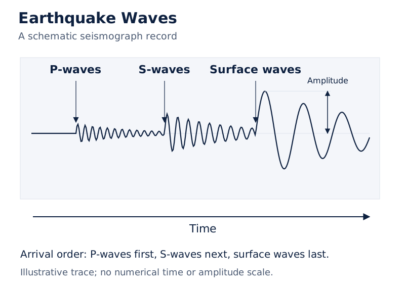
The wave trace marks P-waves first, S-waves next and surface waves last. Arrows identify arrival times, and an amplitude marker appears beside the surface-wave portion of the trace.
Drawn by One Young India. See Fig. 3.1 in your NCERT textbook
What are earthquake shadow zones, and why do they differ?
A shadow zone is an area where earthquake waves are not reported by seismographs. Different earthquakes have different shadow zones. Their location depends on the epicentre, so knowing that location allows the shadow zones of a particular earthquake to be drawn.
Where are P-waves and S-waves recorded?
| Angular distance from epicentre | P-wave record | S-wave record |
|---|---|---|
| Within 105° | Arrival recorded | Arrival recorded |
| Between 105° and 145° | Shadow zone | Shadow zone |
| Beyond 145° | Arrival recorded | No arrival recorded |
The P-wave shadow zone forms a band around the earth between 105° and 145° from the epicentre. P-waves are again recorded beyond 145°. The entire region beyond 105° does not receive S-waves.
The S-wave shadow zone is therefore much larger than the P-wave shadow zone. It covers a little over 40 per cent of the earth’s surface. Keep both the angular limits and the phrase “a little over” when describing its extent.
How do the diagrams connect wave paths with the core?
What the figure shows
Earthquake Shadow Zones
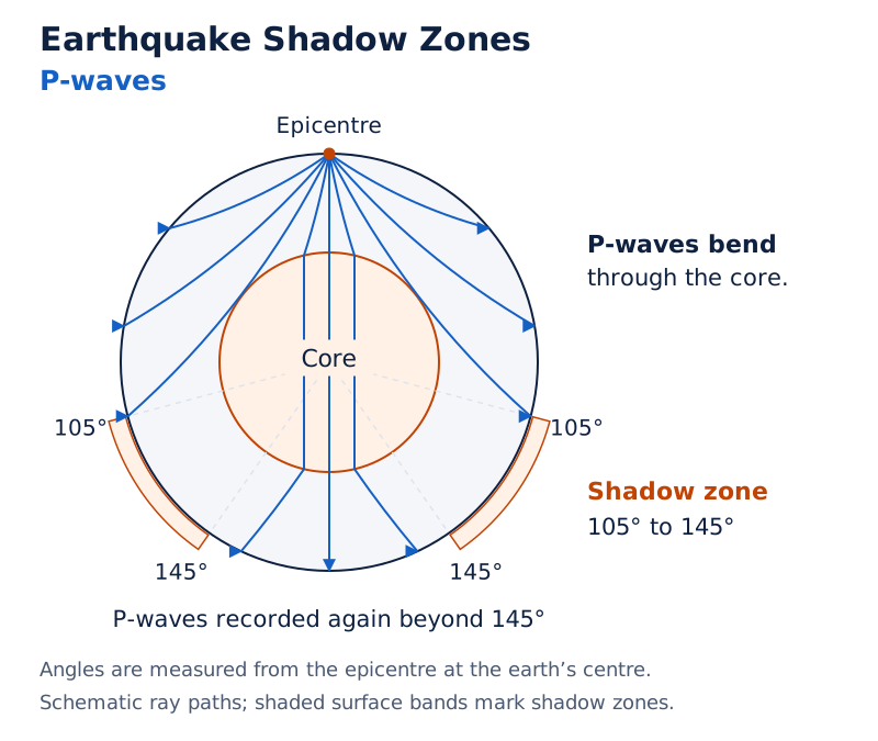
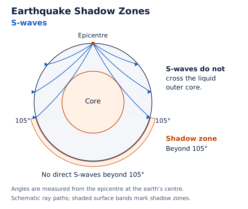
The P-wave panel shows ray paths bending through the earth and shaded bands between 105° and 145°. The S-wave panel shows paths outside the core and a broad shaded zone beyond 105°, labelled as receiving no direct S-waves.
Drawn by One Young India. See Fig. 3.2 in your NCERT textbook
The contrast is linked to wave behaviour in different materials. P-waves travel through liquids as well as solids, whereas S-waves travel only through solids. Changes in paths and the absence of wave arrivals provide evidence used to understand the interior.
What types of earthquakes occur, and how are their effects measured?
Tectonic earthquakes are the most common type. They result from rocks sliding along a fault plane. A special class of tectonic earthquake is sometimes recognised as a volcanic earthquake; these are confined to areas of active volcanoes.
Collapse earthquakes are minor tremors caused when underground mine roofs sometimes collapse in areas of intense mining. Explosion earthquakes result from explosions of chemical or nuclear devices. Earthquakes occurring in areas of large reservoirs are called reservoir induced earthquakes.
How do magnitude and intensity differ?
| Measure | Scale | Basis and range |
|---|---|---|
| Magnitude | Richter scale | Energy released during the quake; expressed as 0 to 10 |
| Intensity | Mercalli scale | Visible damage caused by the event; range 1 to 12 |
The Mercalli scale is named after an Italian seismologist. Magnitude and intensity describe different aspects of an earthquake: the energy released and its visible damage. They should therefore not be treated as interchangeable measurements.
What are the immediate hazardous effects?
- Ground shaking.
- Differential ground settlement.
- Land and mud slides.
- Soil liquefaction.
- Ground lurching.
- Avalanches.
- Ground displacement.
- Floods from dam and levee failures.
- Fires.
- Structural collapse.
- Falling objects.
- Tsunami.
The first six effects have some bearing on landforms. The others may be considered effects causing immediate concern for life and property. High-magnitude tremors can cause heavy damage, although not all parts of the globe necessarily experience major shocks.
The actual quake lasts a few seconds, but its effects are devastating provided its magnitude is more than 5 on the Richter scale. Earthquakes of magnitude 8+ are quite rare, occurring once in 1 to 2 years; “tiny” types occur almost every minute.
A tsunami consists of waves generated by tremors; it is not an earthquake itself. The effect would occur only if the epicentre is below oceanic waters and the magnitude is sufficiently high. Do not omit these conditions.
What the figure shows
Indian Ocean locations
The map within the damage-photo collage labels India, Sri Lanka, Sumatra, Malaysia and Thailand, with concentric lines in the ocean near Sumatra. The surrounding photographs show destruction in India, Sri Lanka, Thailand and Indonesia.
Photograph: Destruction caused by tidal waves at Marina Beach, India. Debris and displaced vehicles lie near the shoreline.
Photograph: Houses destroyed by tidal waves in coastal Colombo, Sri Lanka. People walk through the debris of their houses.
Photograph: Destruction caused by tidal waves in Thailand. A vehicle stands amid damaged structures and debris.
Photograph: Destruction caused by tidal waves in Indonesia. A vehicle is tilted against a damaged structure beside ruined buildings.
Photograph: Damaged Aman Setu at the LOC in Uri due to an earthquake. The bridge deck has collapsed and tilted beside its support.
How are the crust, mantle and core arranged?
The earth’s materials are arranged in layers from the crust to the core. The layers differ in thickness, composition and physical state. Earthquake wave velocities have helped establish the existence of the core and understand the layered interior.
What distinguishes the crust and mantle?
The crust is the earth’s outermost solid part and is brittle. Oceanic crust is thinner than continental crust. Continental crust becomes thicker beneath major mountain systems, reaching as much as 70 km in the Himalayan region.
| Layer or region | Thickness or depth | Characteristic |
|---|---|---|
| Oceanic crust | Mean thickness 5 km | Thinner than continental crust |
| Continental crust | Mean thickness around 30 km | Thicker beneath major mountain systems |
| Himalayan crust | As much as 70 km thick | Example of thick crust beneath mountains |
| Mantle | Extends to a depth of 2,900 km | Begins at Moho’s discontinuity below the crust |
| Asthenosphere | Considered to extend up to 400 km | Weak upper portion of the mantle |
| Lithosphere | Thickness 10 to 200 km | Crust and uppermost mantle together |
| Core-mantle boundary | Depth 2,900 km | Boundary below the mantle |
The mantle extends from Moho’s discontinuity to the core-mantle boundary. Its upper portion, the asthenosphere, takes its name from “astheno”, meaning weak. It is the main source of magma that reaches the surface during volcanic eruptions.
The lithosphere comprises the crust and uppermost mantle. It must not be confused with the crust alone. The lower mantle extends beyond the asthenosphere and is in a solid state.
What are the physical state and composition of the core?
The outer core is liquid, while the inner core is solid. The core consists of very heavy material, mostly nickel and iron, and is sometimes called the nife layer. “Mostly” does not mean that these are its only materials.
What the figure shows
The interior of the earth
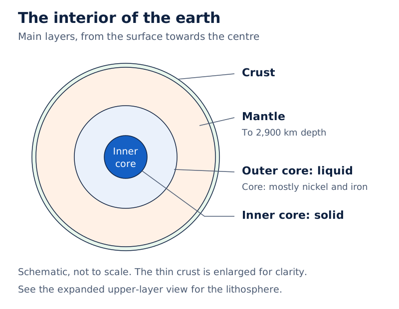
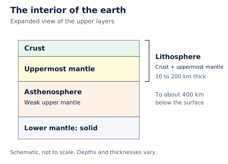
A wedge-shaped section labels the crust, lithosphere, asthenosphere, mantle and core. The core is divided into liquid and solid portions, and the outer labels show the lithosphere spanning the crust and upper mantle.
Drawn by One Young India. See Fig. 3.3 in your NCERT textbook
Depth and thickness answer different questions. The mantle’s lower boundary is described by its depth below the surface, whereas the crust and lithosphere are described by their thicknesses. Preserve that distinction when comparing the values in the table.
What is a volcano, and how do major volcanic types differ?
A volcano is a place where gases, ashes and/or molten rock material escape to the ground. It is active if these materials are being released or have been released in the recent past. Classification depends on the nature of eruption and the form developed at the surface.
How are magma and lava related?
The mantle has a higher density than the crust and contains the weaker asthenosphere. Molten rock material comes from this zone towards the surface. Material in the upper mantle is called magma; once moving towards the crust or reaching the surface, it is called lava.
Material reaching the ground includes lava flows, pyroclastic debris, volcanic bombs, ash, dust and gases. An eruption therefore involves more than a flowing mass of molten rock. The character of this material helps distinguish volcanic forms.
How do shield and composite volcanoes compare?
Shield volcanoes, barring basalt flows, are the largest volcanoes on earth. Hawaiian volcanoes are the most famous examples. They are mostly made of basalt, which is very fluid when erupted, so these volcanoes are not steep.
Shield volcanoes have low explosivity unless water enters the vent, when they become explosive. Upcoming lava moves as a fountain and develops a cinder cone at the top of the vent.
Composite volcanoes erupt cooler, more viscous lava than basalt and often produce explosive eruptions. Large quantities of pyroclastic material and ash accompany the lava. These materials accumulate near vent openings in layers, giving the volcanic mount its composite character.
What distinguishes calderas, flood basalts and ridge volcanoes?
Caldera volcanoes are the most explosive. They are usually so explosive that they tend to collapse on themselves during eruption rather than build a tall structure. The resulting collapsed depressions are calderas. Their explosiveness indicates a huge magma chamber in close vicinity.
Flood basalt provinces form through outpourings of highly fluid lava that travels long distances. Some regions contain thousands of sq. km of thick basalt flows. Some individual flows exceed 50 m in thickness and may extend for hundreds of km.
Mid-ocean ridge volcanoes occur in oceanic areas. The mid-ocean ridge system stretches for more than 70,000 km through all ocean basins. Its central portion experiences frequent eruptions.
These types should be compared through their eruption material, explosivity and resulting form. Fluid basalt helps explain gentle shield slopes and widespread flood flows, while the layered accumulation of lava and pyroclastic material explains composite volcanoes.
How do intrusive volcanic landforms develop inside the crust?
Lava cools to form igneous rocks. Cooling at the surface produces volcanic rocks, while cooling within the crust produces plutonic rocks. Material cooling within crustal portions takes different shapes, known as intrusive forms.
What are batholiths and lacoliths?
Batholiths are large bodies of magmatic material that cool deep in the crust and develop as large domes. They are granitic bodies and represent cooled portions of magma chambers. They cover large areas and at times may extend several km in depth.
Batholiths appear at the surface only after denudational processes remove the overlying material. Their formation at depth and later exposure are separate stages. A visible granitic body does not therefore mean that the material originally cooled at the surface.
Lacoliths are large dome-shaped intrusive bodies with level bases and pipe-like conduits connecting them from below. They resemble the surface domes of composite volcanoes but lie deeper. A lacolith can be regarded as a localised source of lava reaching the surface.
How do lapoliths, phacoliths, sills and dykes differ?
| Intrusive form | Shape or position | Distinguishing feature |
|---|---|---|
| Lapolith | Saucer-shaped body, concave towards the sky | Develops as rising lava moves horizontally along a weak plane |
| Phacolith | Wavy intrusive mass at the base of synclines or top of anticlines | Has a definite conduit to a magma chamber beneath |
| Sheet | Thin, near-horizontal intrusive body | Distinguished from a sill by smaller thickness |
| Sill | Thick, near-horizontal intrusive deposit | Distinguished from a sheet by greater thickness |
| Dyke | Wall-like body almost perpendicular to the ground | Forms when lava solidifies in cracks and fissures |
As lava rises, some of it may move horizontally where it finds a weak plane. Its resting shape may become a saucer-shaped lapolith. Wavy intrusive masses found at times in folded igneous country are phacoliths, connected to their source below.
Sills and sheets are near horizontal and differ by thickness. Dykes form as lava passes through cracks and fissures, cools in place and develops a wall-like structure almost perpendicular to the ground.
What the figure shows
Volcanic Landforms
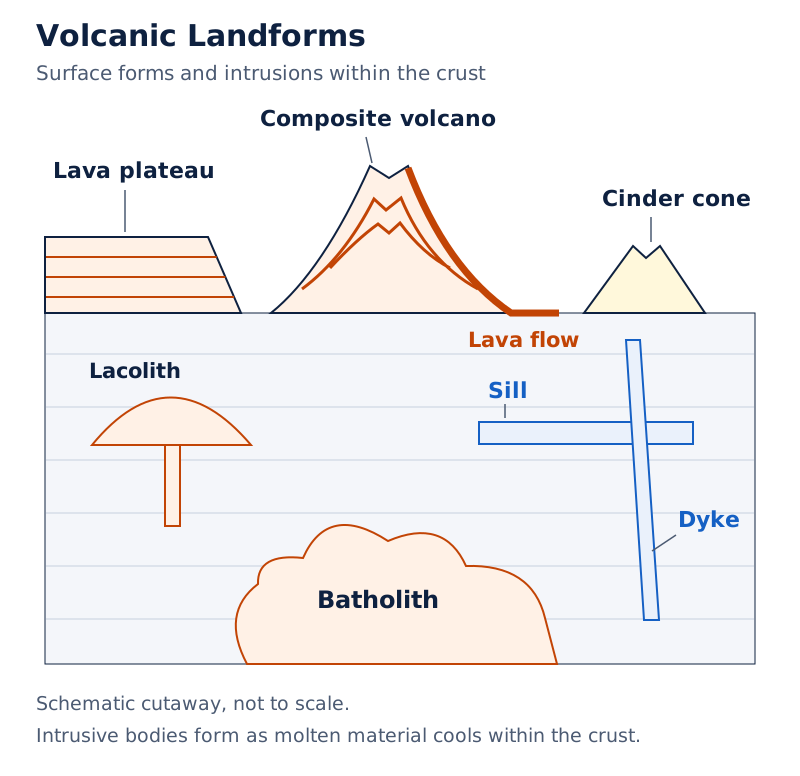
A block diagram combines surface volcanic forms with underground intrusions. Labels include a lava plateau, composite volcano, cinder cone, lava flow, sill, laccolith, dyke and batholith. The cutaway exposes rock layers and intrusive bodies beneath the surface.
Drawn by One Young India. See Fig. 3.4 in your NCERT textbook
What do the Deccan Traps and Karnataka plateau examples illustrate?
Regional examples connect volcanic processes with recognisable landforms. The Deccan Traps illustrate widespread basalt flows, while the Karnataka plateau provides examples of exposed granitic domal hills. Dykes in western Maharashtra link intrusive forms with the supply of material for eruptions.
Case study: How do the Deccan Traps illustrate flood basalt volcanism?
The Deccan Traps form a much larger flood basalt province in India, presently covering most of the Maharashtra plateau. Highly fluid lava outpourings can travel long distances and accumulate in successive flows, producing extensive basalt-covered regions.
It is believed that the trap formations initially covered a much larger area than they do at present. This is a qualified statement about their former extent. The present extent and the believed initial extent should not be treated as identical.
Dykes are the most commonly found intrusive forms in western Maharashtra. They are considered the feeders for the eruptions that produced the Deccan Traps. Their role connects lava moving through cracks below ground with the development of surface volcanic formations.
Case study: What do Karnataka’s granitic domal hills show?
The Karnataka plateau is dotted with domal hills of granite. Most of these, now exfoliated, are examples of lacoliths or batholiths. These hills should not all be classified as lacoliths; batholiths are also represented.
The forms differ in their geometry and origin at depth. Lacoliths are dome-shaped bodies with level bases and conduits beneath them. Batholiths are large granitic bodies formed from cooled magma chambers and exposed after overlying material is removed.
Together, the examples connect volcanic activity at the surface with intrusive forms within the crust. The Deccan example concerns extensive basalt flows and their considered feeders; the Karnataka example concerns exposed granitic bodies with dome-like forms.
Glossary
- Fault — A sharp break in crustal rocks along which movement can release earthquake energy.
- Focus — The point within the earth where earthquake energy is released, also called the hypocentre.
- Epicentre — The surface point nearest to the focus, located directly above it.
- Body waves — Earthquake waves generated at the focus that travel through the body of the earth.
- Surface waves — Waves generated by body waves interacting with surface rocks, travelling along the earth’s surface.
- Shadow zone — An area where earthquake waves are not reported by seismographs for a particular earthquake.
- Gravity anomaly — The difference between the observed gravity reading at a place and its expected value.
- Lithosphere — The crust and uppermost mantle together, with thickness ranging from 10 to 200 km.
- Asthenosphere — The weak upper portion of the mantle, serving as the main source of volcanic magma.
- Nife — A name sometimes used for the core, whose heavy materials are mostly nickel and iron.
- Caldera — A collapsed depression formed when an explosive volcano collapses on itself during eruption.
- Batholith — A large granitic intrusive body representing a cooled portion of a magma chamber.
- Lacolith — A large dome-shaped intrusive body with a level base and a pipe-like conduit below.
- Dyke — A wall-like intrusive structure formed as lava cools in cracks almost perpendicular to the ground.
- Sill — A thick, near-horizontal intrusive igneous body, distinguished from a thinner sheet.
Common errors and misconceptions
- Misconception: Meteor material is a direct sample of the earth’s interior. Correct: It is not from the interior; similarities in materials and structure make meteors an indirect source.
- Misconception: The focus and epicentre are the same point. Correct: The focus is the energy-release point within the earth; the epicentre is directly above it on the surface.
- Misconception: Both P-waves and S-waves pass through liquids. Correct: P-waves pass through gases, liquids and solids, while S-waves travel only through solids.
- Misconception: P-waves and S-waves have identical shadow zones. Correct: P-waves have a shadow band between 105° and 145°; the S-wave shadow zone extends throughout the region beyond 105°.
- Misconception: Earthquake magnitude and intensity measure the same thing. Correct: Magnitude relates to energy released, whereas intensity concerns visible damage.
- Misconception: The lithosphere is simply another name for the crust. Correct: It includes both the crust and the uppermost part of the mantle.
- Misconception: The whole core is liquid. Correct: The outer core is liquid, but the inner core is solid.
- Misconception: Every earthquake produces a tsunami. Correct: The tsunami effect requires an epicentre below oceanic waters and a sufficiently high magnitude; tsunami waves are not themselves earthquakes.
Exam-style questions with model answers
Q1. Distinguish between the focus and epicentre. [2 marks]
- The focus, or hypocentre, is the point within the earth where earthquake energy is released.
- The epicentre is the nearest surface point, directly above the focus, and experiences the waves first.
Q2. Name the direct sources of information about the earth’s interior and one limitation. [3 marks]
- Surface rocks and rocks obtained from mining areas provide solid material for direct examination.
- Deep drilling projects provide materials collected at different depths, whose analysis reveals crustal conditions.
- Volcanic eruptions bring molten material to the surface for laboratory analysis. However, the depth of the source of this erupted magma is difficult to ascertain.
Q3. Explain how movement along a fault causes an earthquake. [3 marks]
- A fault is a sharp break in crustal rocks. Rocks along it tend to move in opposite directions.
- Pressure from overlying strata and friction lock the rocks together until the tendency to move overcomes the friction.
- The blocks deform and abruptly slide past one another. This releases energy at the focus, generating waves that travel in all directions and reach the surface.
Q4. Compare earthquake waves and explain their effects on rocks. [5 marks]
- Body waves originate through energy release at the focus and travel through the earth. Their interaction with surface rocks produces surface waves.
- P-waves are faster and arrive first. They travel through gases, liquids and solids, vibrating parallel to their direction of movement. They exert pressure and produce stretching and squeezing in the material.
- S-waves arrive later and travel only through solids. Their vibrations are perpendicular to propagation in the vertical plane, creating troughs and crests.
- Wave velocity and direction change in materials of different densities. Reflection makes waves rebound, while refraction changes their direction.
- Surface waves arrive last and are considered the most damaging. They displace rocks and cause structures to collapse.
Q5. Describe the P-wave and S-wave shadow zones. [3 marks]
- Within 105° of the epicentre, seismographs record both P-waves and S-waves. Between 105° and 145°, neither is recorded.
- Beyond 145°, P-waves are recorded again, but S-waves are absent. The P-wave shadow zone is therefore the band between 105° and 145°.
- The S-wave shadow zone includes the entire region beyond 105°. It is much larger and covers a little over 40 per cent of the earth’s surface.
Q6. Describe the main layers of the earth’s interior. [5 marks]
- The crust is the outermost solid, brittle layer. Mean oceanic crust thickness is 5 km, while continental crust averages around 30 km and reaches as much as 70 km in the Himalayan region.
- The mantle extends from Moho’s discontinuity to a depth of 2,900 km. Its weak upper portion, the asthenosphere, is considered to extend up to 400 km and supplies magma for eruptions.
- The lithosphere comprises the crust and uppermost mantle, with thickness from 10 to 200 km. The lower mantle beyond the asthenosphere is solid.
- The core-mantle boundary lies at 2,900 km. The outer core is liquid and the inner core solid.
- The core consists mostly of nickel and iron and is sometimes called the nife layer.
Q7. Explain the main intrusive volcanic forms. [5 marks]
- Intrusive forms develop when lava cools within the crust. Batholiths are large granitic bodies formed deep within it, representing cooled magma chambers. Denudation exposes them.
- Lacoliths are dome-shaped bodies with level bases and pipe-like conduits from below. Lapoliths are saucer-shaped bodies concave towards the sky.
- Phacoliths are wavy intrusive masses found at times at the base of synclines or top of anticlines, with conduits to magma chambers below.
- Sills and sheets are near-horizontal intrusive bodies. Sills are the thicker deposits, while sheets are thinner.
- Dykes develop where lava solidifies in cracks and fissures almost perpendicular to the ground, producing wall-like structures.
Q8. Compare shield and composite volcanoes. [4 marks]
- Lava: Shield volcanoes erupt very fluid basaltic lava; composite volcanoes erupt cooler, more viscous lava than basalt.
- Explosivity: Shield volcanoes have low explosivity unless water enters the vent; composite volcanoes often erupt explosively.
- Erupted material: Shield volcanoes are mostly basaltic; composite volcanoes eject large quantities of pyroclastic material and ash along with lava.
- Form: Fluid basalt produces shield volcanoes that are not steep; lava, ash and pyroclastic material accumulate in layers near composite-volcano vents.
Key takeaways
- Most knowledge of the earth’s interior is largely based on estimates and inferences, supported by direct observations and material analysis.
- Earthquakes release energy along faults; the focus is within the earth and the epicentre directly above it.
- P-waves travel through gases, liquids and solids, while S-waves travel only through solids and arrive later.
- The P-wave shadow zone lies between 105° and 145°, while the S-wave shadow zone extends beyond 105°.
- The lithosphere includes the crust and uppermost mantle; the asthenosphere is a weak upper-mantle zone supplying magma.
- The outer core is liquid and the inner core solid; the core consists mostly of nickel and iron.
- Volcanoes differ in eruption style and surface form, including shield, composite, caldera, flood basalt and mid-ocean ridge types.
- Intrusive forms result from cooling within the crust and include batholiths, lacoliths, lapoliths, phacoliths, sills, sheets and dykes.
Test yourself
Why are meteors an indirect source of information?
Their material is not from the earth’s interior, but similarities in their materials and structure provide comparative evidence about it.
What does a gravity anomaly reveal?
A gravity anomaly provides information about the distribution of mass of material in the earth’s crust.
Which earthquake waves arrive last and are considered most damaging?
Surface waves arrive last. They displace rocks and cause the collapse of structures.
What is the difference between the Richter and Mercalli scales?
The Richter scale measures magnitude in relation to energy released. The Mercalli scale measures intensity through visible damage.
How does the asthenosphere relate to volcanic eruptions?
This weak upper portion of the mantle is the main source of magma that reaches the surface during volcanic eruptions.
Why are shield volcanoes not steep?
They are mostly made of basalt, which is very fluid when erupted, so the volcanoes are not steep.
How does a dyke differ from a sill?
A dyke forms a wall-like body almost perpendicular to the ground. A sill is a thick, near-horizontal intrusive deposit.
What qualification is needed when identifying Karnataka’s granitic domal hills?
Most, rather than all, of the now-exfoliated granitic domal hills are examples of lacoliths or batholiths. They should not all be assigned to just one of these forms.
Write about it
Turn a question from this chapter into a paper.
The Writing Studio has a structure guide, a rubric and citation tools for 15 formats, from essays to research papers. Drafting is free with an account. Learnacy Essential adds feedback from an AI writing coach and submission to The OYI Review.
Learnacy Essential is ₹1,499 for the year. Publication depends on review and is not guaranteed.