
The Atmosphere | ICSE Class 9 Geography Notes
On this page

This note covers atmospheric composition and layers, ozone depletion, global warming, insolation, temperature controls, pressure belts, winds, humidity, condensation, precipitation and the three main types of rainfall.
What is the atmosphere and what does it contain?
The atmosphere is the mixture of gases surrounding Earth. Gravity, Earth's pull on matter, holds it in place. Air contains gases, water vapour and suspended particles. Nitrogen accounts for 78% and oxygen for 21%; the symbol % means per cent, or parts per hundred.
The remaining constituents include argon, carbon dioxide and other gases. Oxygen supports breathing in humans and animals, while plants use carbon dioxide. The proportion of a gas alone does not determine its importance: small quantities can strongly affect atmospheric processes.
Why do water vapour and dust matter?
Water vapour is water in its gaseous state. In warm, wet tropical regions it may form four per cent of air by volume. In dry, cold desert and polar areas it may be less than one per cent. Its amount decreases with altitude, or height.
Water vapour absorbs some incoming solar energy and helps preserve heat radiated by Earth. It also supplies moisture for clouds, masses of minute droplets or ice crystals in the air, and for precipitation, the fall of liquid or solid water from the atmosphere to Earth's surface.
Dust particles include sea salt, fine soil, soot, ash and pollen. They are generally concentrated in lower atmospheric layers, although rising air currents may carry them higher. Dust and salt provide hygroscopic nuclei, small moisture-attracting particles around which water vapour condenses into liquid droplets.
Definition: Weather is the momentary state of the atmosphere. Climate is the average of weather conditions over a longer period. Their elements include temperature, pressure (force exerted by air per unit area), wind (horizontal air movement), humidity (water vapour in air), clouds and precipitation.
How are the layers of the atmosphere arranged?
Atmospheric density, the mass of air in a given volume, is highest near Earth's surface and decreases upwards. Layers differ in temperature and density. In the measurements below, km means kilometre, m means metre, and °C means degrees Celsius.
What makes the lower layers important?
The troposphere is the lowest layer. Its average height is 13 km; it extends roughly to 8 km near the poles and about 18 km at the equator. Strong upward air currents carry heat to greater heights near the equator.
This layer contains dust and water vapour. Nearly all weather phenomena take place here, and it is the most important layer for biological activity. The tropopause separates it from the stratosphere. The stratosphere extends upwards to 50 km and contains the protective layer of ozone, a form of oxygen that filters harmful solar radiation.
What lies above the stratosphere?
The mesosphere extends to 80 km. Its temperature decreases upwards, and its upper boundary is the mesopause. The ionosphere, described between 80 and 400 km, contains ions, or electrically charged particles. It reflects radio waves back towards Earth.
The thermosphere is the upper atmospheric layer in which temperature rises with height. Above it lies the exosphere, whose contents are extremely rarefied, meaning very thinly spread. This outermost layer gradually merges with outer space.
What the figure shows
Structure of the atmosphere
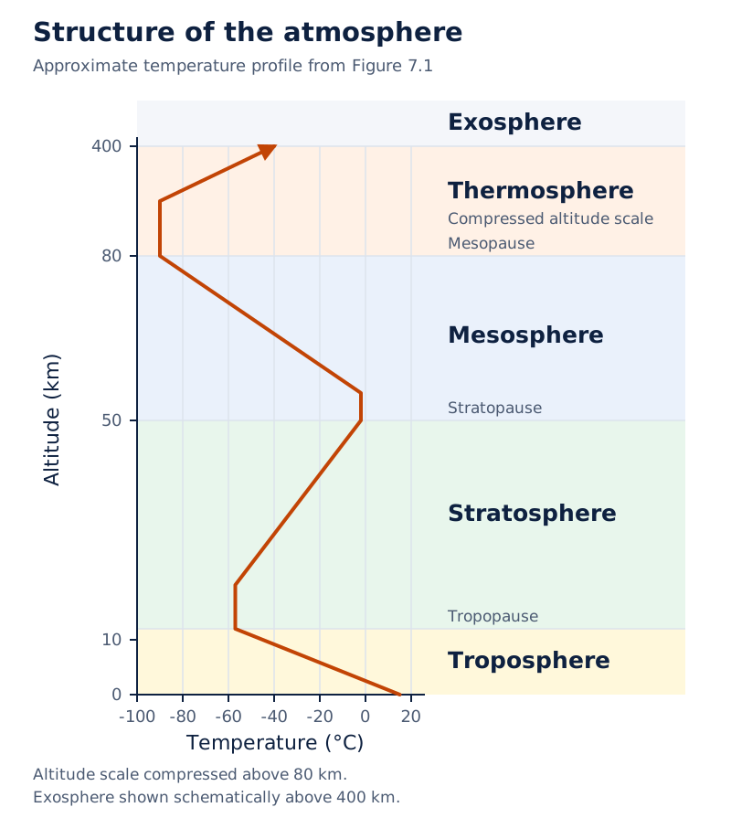
The vertical axis gives altitude in kilometres and the horizontal axis gives temperature in degrees Celsius. The labelled layers include troposphere, stratosphere, mesosphere, thermosphere and exosphere. A bent line traces temperature changes through the layers.
Drawn by One Young India.
Why do ozone depletion and global warming matter?
Ozone is a form of oxygen that absorbs harmful ultraviolet radiation from the Sun. Ultraviolet radiation is an invisible part of solar radiation. Stratospheric ozone acts as a protective filter, shielding life from this intense form of energy.
How does ozone depletion occur?
Ozone depletion means a reduction in ozone concentration. Chlorofluorocarbons, abbreviated as CFCs, are human-made chemicals used in refrigerators and aerosols. CFCs that drift into the stratosphere destroy ozone. Large depletion over Antarctica is called the ozone hole.
This is thinning of the protective ozone layer. It allows more harmful ultraviolet radiation to pass through, which can harm living organisms and ecosystems. Ozone protection concerns the filtering of solar radiation before it reaches the surface.
How does the greenhouse effect differ?
Greenhouse gases absorb outgoing long-wave radiation, the energy Earth emits after being heated. Incoming solar energy is mainly short-wave radiation. The greenhouse effect is the warming associated with the atmosphere's absorption of outgoing heat. Carbon dioxide, methane and nitrous oxide are greenhouse gases.
Global warming is an increase in Earth's average temperature. Burning fossil fuels, such as coal, oil and gas, adds carbon dioxide. Deforestation, the removal of forests, also increases its concentration by reducing uptake during plant growth.
The effect of global warming may not be uniform everywhere. Melting glaciers and ice caps, together with thermal expansion, the increase in seawater's volume as it warms, raise sea level. This may inundate, or flood, large parts of coastal areas and islands, creating social problems.
How do insolation and terrestrial radiation heat the atmosphere?
Insolation means incoming solar radiation. Earth receives most of its energy in short wavelengths. The atmosphere is largely transparent to this radiation, so much of it reaches the surface. Water vapour and other gases absorb some radiation during its passage.
Terrestrial radiation is the long-wave energy emitted by the heated Earth. Atmospheric gases, particularly carbon dioxide and other greenhouse gases, absorb it. The atmosphere is therefore indirectly heated from below, rather than receiving all its heat directly from sunlight.
How is heat transferred?
| Process | Meaning | Atmospheric role |
|---|---|---|
| Conduction | Heat transfer between bodies in contact | Warmer ground heats the air touching it |
| Convection | Heat transfer through vertical movement of air | Heated air rises in currents within the troposphere |
| Advection | Heat transfer through horizontal movement of air | Moving air carries heat from one region to another |
During conduction, energy flows from the warmer body to the cooler body. Transfer continues until their temperatures become equal or contact ends. Convection moves heat upwards; advection transfers it sideways. These processes help explain how surface heating influences air beyond the ground itself.
What is Earth's heat balance?
The heat budget is the balance between incoming and outgoing energy. In a balanced system, energy received from the Sun equals energy returned to space. The albedo describes the reflected portion of incoming radiation.
The balance varies by region: lower latitudes have surplus energy while regions near the poles have a deficit. Atmospheric circulation redistributes heat towards higher latitudes. A global balance therefore does not mean that every place receives and loses equal amounts locally.
Which factors control the temperature of a place?
Temperature measures how hot or cold something is. Air temperature depends on latitude, altitude, distance from the sea, slope, winds and ocean currents. These controls act together, so places at the same latitude need not have identical temperatures.
How do latitude, altitude and slope operate?
Latitude is angular distance north or south of the equator, measured in degrees. At higher latitudes, sunlight arrives more obliquely. Its energy spreads over a larger area, and its passage through a greater depth of atmosphere increases absorption and scattering.
Temperature generally decreases with altitude. The normal lapse rate, or rate of decrease with height, is 6.5°C per 1,000 m. This is a general rate, not a guarantee for every place and time. An inversion occurs when temperature increases upwards instead.
The aspect of a slope is the direction it faces. Slopes facing the Sun receive more direct solar energy than slopes facing away under comparable conditions. Slope therefore affects local heating by changing exposure to sunlight.
How do the sea, winds and currents modify temperature?
Land heats and cools quickly; the sea heats and cools slowly. Coastal places experience the sea's moderating influence. Air masses, large bodies of air with little horizontal variation in temperature and moisture, carry warmer or colder conditions into a region.
Ocean currents are movements of ocean water. Coasts influenced by warm currents record higher temperatures than coasts influenced by cold currents. Winds transfer these temperature influences through the movement of air.
Case study: Why is the North Atlantic relatively warm in January?
The Gulf Stream and North Atlantic Drift are warm ocean currents that make the northern Atlantic warmer. Isotherms, lines joining places of equal temperature, bend northwards over the ocean. Over Europe, land temperatures fall sharply and the isotherms bend southwards.
What causes atmospheric pressure and where are its major belts?
Atmospheric pressure is the weight of the overlying column of air acting on a unit area. A barometer measures it. The pressure unit used here is the millibar, abbreviated as mb. Pressure generally decreases as elevation increases.
Heating expands air, while cooling compresses it. Temperature differences help produce pressure differences and air movement. At the same temperature and pressure, moist air is less dense than dry air. Moisture can therefore also influence air density and pressure conditions.
How does pressure change with height?
In the lower atmosphere, the decrease is about 1 mb for each 10 m rise, but it does not always occur at the same rate. The following standard-atmosphere values show why pressure at different elevations cannot be compared as though altitude had no effect.
| Level | Pressure in mb | Temperature in °C |
|---|---|---|
| Sea Level | 1,013.25 | 15.2 |
| 1 km | 898.76 | 8.7 |
| 5 km | 540.48 | −17.3 |
| 10 km | 265.00 | −49.7 |
Where are the pressure belts?
A pressure belt is a broad zone of relatively high or low pressure. In the table, ° means degrees of latitude, N means north and S means south. The belts shift with the apparent movement of the Sun.
| Belt | Approximate location | Pressure |
|---|---|---|
| Equatorial low | Near 0°, the equator | Low |
| Subtropical highs | Along 30° N and 30° S | High |
| Subpolar lows | Along 60° N and 60° S | Low |
| Polar highs | Near the north and south poles | High |
Isobars connect places with equal pressure. Weather maps use pressure reduced to sea level to remove the effect of elevation. A low-pressure system has its lowest pressure at the centre; a high-pressure system has its highest pressure there.
What controls the direction and speed of wind?
Wind is air in horizontal motion. Pressure differences set it moving from high towards low pressure. Its speed and direction near Earth's surface reflect the combined effects of pressure differences, Earth's rotation and friction.
How does the pressure gradient affect wind?
The pressure gradient is the rate of pressure change with distance. A large pressure difference over a short distance gives a steep gradient. Closely spaced isobars indicate a strong gradient; widely spaced isobars indicate a weak gradient.
The pressure-gradient force acts from higher towards lower pressure. A stronger gradient produces a stronger driving force. This explains why the spacing of isobars matters when interpreting winds, rather than merely whether the map contains a high or a low.
What do rotation and friction do?
The Coriolis effect is the deflection of moving air associated with Earth's rotation. Winds deflect to their right in the Northern Hemisphere and to their left in the Southern Hemisphere. The effect is maximum at the poles and absent at the equator.
Friction is the resistance experienced as air moves over the surface. It affects wind speed, is greatest near the surface and generally influences air up to 1 to 3 km. Over the sea surface, friction is minimal.
Note: Coriolis deflection is relative to the wind's direction of travel. Pressure differences start the horizontal movement, while rotation changes its direction. A wind therefore need not follow a straight path directly towards a low-pressure centre.
How do permanent winds connect the pressure belts?
Permanent winds, also called planetary winds, form the broad pattern of atmospheric circulation. Their arrangement depends largely on unequal heating, pressure belts, seasonal belt migration, land and ocean distribution, and Earth's rotation.
Which are the three main wind systems?
| Wind system | General surface route | Direction pattern |
|---|---|---|
| Trade winds | Subtropical highs towards the equatorial low | Northeast trades north of the equator; southeast trades south of it |
| Westerlies | Subtropical highs towards subpolar lows | Winds with a prevailing west-to-east component |
| Polar easterlies | Polar highs towards subpolar lows | Winds with a prevailing east-to-west component |
The Inter Tropical Convergence Zone, abbreviated as ITCZ, is the low-pressure zone where the trade winds meet. Convergence means air coming together. Strong heating makes air rise here, and the converging winds supply more air from either side.
- Strong equatorial heating causes air to rise, producing a low-pressure zone.
- Air reaching the upper troposphere moves towards higher latitudes.
- Air accumulates and part of it sinks near 30° north and south, forming subtropical highs.
- Surface air returns towards the equator as trade winds, completing a tropical circulation cell.
A circulation cell is a loop of rising, horizontal and sinking air movement. The tropical loop is the Hadley cell. The middle-latitude loop is the Ferrel cell, while the high-latitude loop is the polar cell.
What the figure shows
Simplified general circulation of the atmosphere
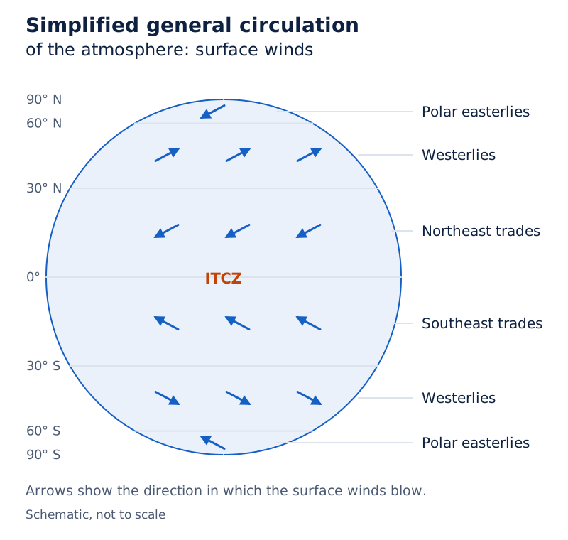
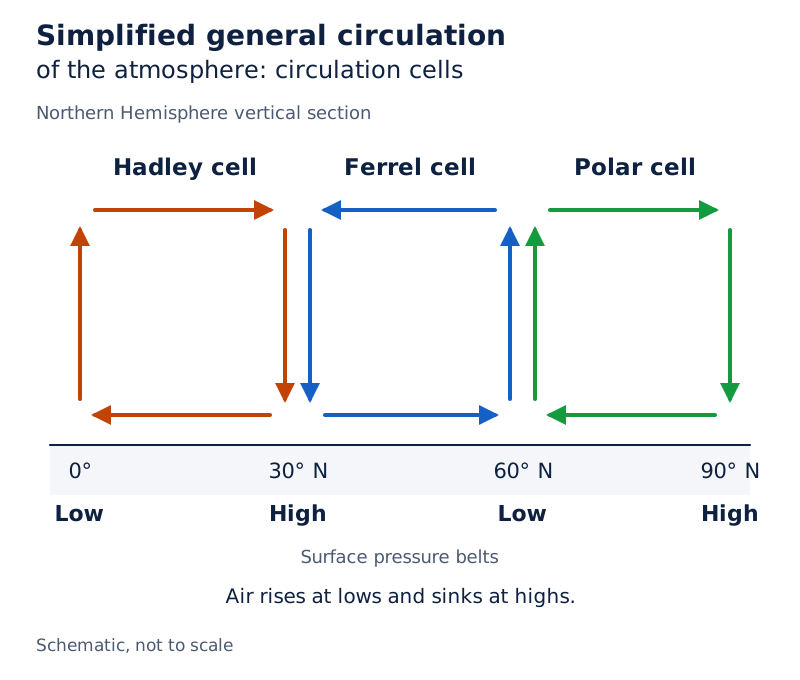
A globe is crossed by latitude lines and wind arrows. Labels identify northeast and southeast trades, westerlies, polar easterlies, and the Hadley, Ferrel and polar cells.
Drawn by One Young India.
How do periodic winds and jet streams influence weather?
Periodic winds reverse with a regular daily or seasonal cycle. Land and sea breezes respond to daily heating differences. Monsoons involve a seasonal reversal of wind direction, associated with shifts in heating, pressure and circulation.
Why do coastal breezes reverse?
- During the day, land heats faster than the neighbouring sea.
- Air rises over the warmer land, producing relatively low pressure there.
- Higher pressure over the cooler sea drives a sea breeze towards land.
- At night, land cools faster, reversing the pressure gradient and producing a land breeze towards the sea.
What the figure shows
Land and sea breezes
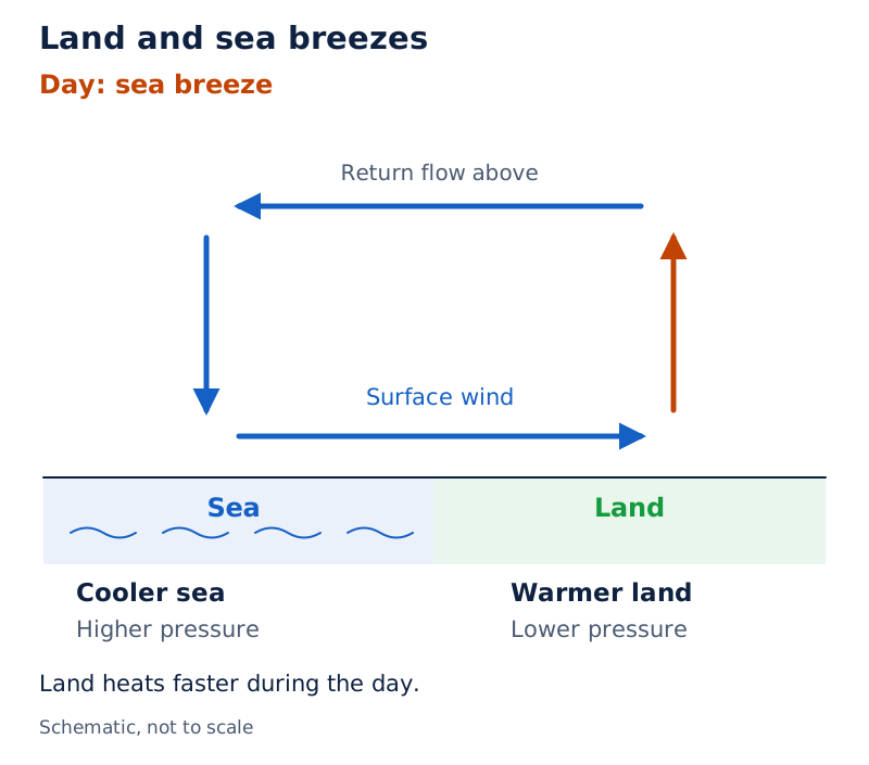
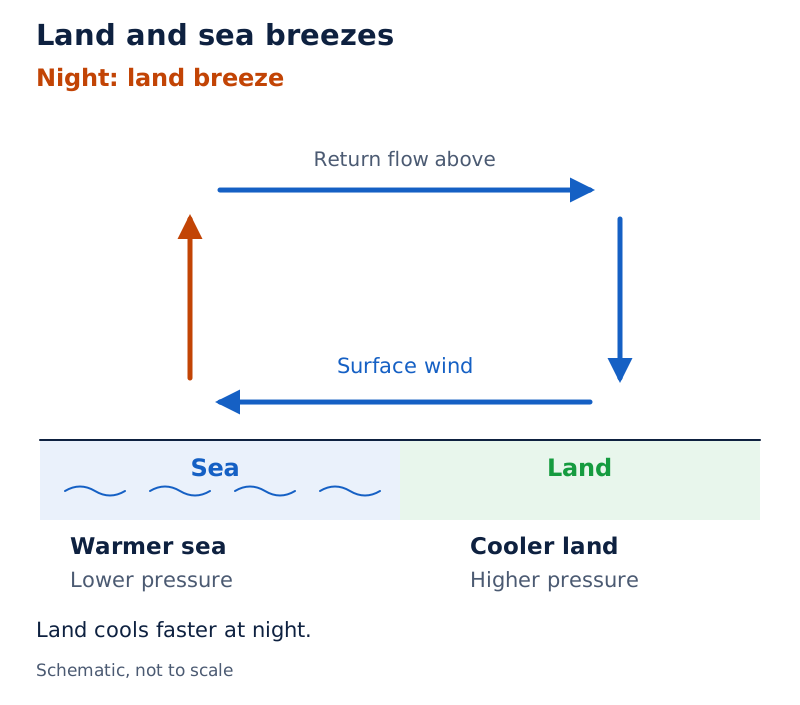
Two coastal sketches show circulating arrows. The sea-breeze sketch has surface arrows from sea to land; the land-breeze sketch reverses the surface arrows. Each shows a return flow above.
Drawn by One Young India.
How do monsoons and upper winds change?
In the Indian summer, strong heating and the northward ITCZ shift help draw winds towards the subcontinent. Southeast trades cross the equator and become southwest monsoon winds. In winter, the ITCZ moves southwards and the winds reverse towards a northeasterly pattern.
Jet streams are narrow bands of very fast winds high in the troposphere. Their seasonal positions influence weather systems. The withdrawal of the westerly jet from south of the Himalayas is related to the northward ITCZ shift; an easterly jet then develops over India.
What the figure shows
January pressure distribution
The map contains numbered isobars, wind arrows and an ITCZ line. H denotes high pressure and L denotes low pressure. A large H is marked over interior Asia.
What the figure shows
July pressure distribution
The map again shows isobars, wind arrows and the ITCZ. An L is marked over Asia, and the ITCZ bends northwards over the Asian landmass compared with its January position.
How do local winds affect particular regions?
Local winds occur over limited areas because of local heating, cooling and relief. Relief means the height and shape of the land. Such winds can bring marked changes in temperature and dryness without representing the entire planetary wind system.
Which named local winds are important?
The windward slope faces the approaching wind, while the leeward slope lies on the sheltered side.
| Wind | Region | Main character |
|---|---|---|
| Loo | Northern Indian plains from Punjab to Bihar | Hot, dry and oppressive summer wind |
| Chinook | Eastern slopes of the Rocky Mountains in North America | Warm, dry descending wind |
| Foehn | Leeward slopes of the Alps in Europe | Warm, dry descending wind |
| Mistral | Rhône valley towards the Mediterranean coast of France | Cold, dry wind |
The Loo has greater intensity between Delhi and Patna. It blows in the afternoon and very often continues well into midnight. It illustrates how horizontal movement of hot air affects the weather of northern India in summer.
Why can a descending mountain wind become warm?
Air crossing a mountain may lose moisture through condensation and precipitation. Descending dry air then warms through compression.
This warming is adiabatic, meaning that it occurs without heat exchange with the surroundings. Warm, dry descending air may melt snow in a short time. Chinook and Foehn are examples of this type of mountain wind; Mistral has a contrasting cold character.
How do cyclones and anticyclones differ?
Variable winds accompany changing pressure systems rather than following a fixed daily or seasonal reversal. A cyclone is a circulation around low pressure. An anticyclone is a circulation around high pressure. Their rotation differs between hemispheres.
| System | Central pressure | Northern Hemisphere | Southern Hemisphere |
|---|---|---|---|
| Cyclone | Low | Anticlockwise | Clockwise |
| Anticyclone | High | Clockwise | Anticlockwise |
Generally, air converges and rises over a low-pressure area. Over a high-pressure area, air subsides, meaning that it sinks from above, and diverges, or spreads outwards, at the surface. Rising moist air cools and can produce clouds and precipitation.
What distinguishes tropical and extra-tropical cyclones?
Tropical cyclones are violent storms originating over warm tropical oceans. Moisture from the sea supplies energy through condensation. They bring violent winds, very heavy rainfall and storm surges, storm-driven rises of seawater that flood coastal lowlands.
The eye is the calm central region with sinking air. The surrounding eyewall has strong ascending winds and torrential rain. The calm eye must therefore be distinguished from the violent zone around it.
Extra-tropical cyclones develop beyond the tropics in middle and high latitudes. They have fronts, boundaries between different air masses, and can originate over land or sea. Tropical cyclones lack this clear frontal system.
At a warm front, advancing warm air rises over colder air. At a cold front, advancing cold air pushes warmer air upwards. Both processes help explain the cloud formation and rainfall associated with frontal weather systems.
What do humidity, evaporation and condensation mean?
Humidity is water vapour present in air. Evaporation changes liquid water into vapour, adding moisture to the atmosphere. Transpiration, the release of water vapour by plants, also supplies atmospheric moisture. Water continually moves between air, oceans and continents.
How do absolute and relative humidity differ?
| Measure | Definition | Expression |
|---|---|---|
| Absolute humidity | Actual mass of water vapour per unit volume of air | Grams per cubic metre |
| Relative humidity | Moisture present compared with full capacity at the same temperature | A percentage |
Saturated air contains moisture to its full capacity at a given temperature. The dew point is the temperature at which a given air sample becomes saturated. Because moisture-holding capacity changes with temperature, relative humidity can change even without adding water vapour.
How does moisture enter and leave the air?
Heat is the main cause of evaporation. Higher temperature increases the air's capacity to retain moisture. Moving air replaces a saturated layer with unsaturated air, so greater movement of air increases evaporation.
Condensation changes water vapour into liquid water through loss of heat. Cooling moist air may bring it to saturation, after which excess vapour condenses. In free air, droplets form around hygroscopic nuclei such as dust, smoke and salt particles.
Condensation can also occur when moist air touches a colder object. The amount of cooling and the relative humidity both matter. A decrease in air temperature is the most favourable condition for condensation, but moisture supply also affects when saturation is reached.
What forms do condensation and precipitation take?
Condensation produces different forms according to temperature and location. Dew consists of water droplets deposited on cool solid surfaces such as grass and leaves. Clear skies, calm air, high relative humidity and long, cold nights favour its formation.
Frost consists of minute ice crystals deposited on cold surfaces when the dew point is at or below the freezing point, 0°C. Dew requires a dew point above freezing. The physical form of the deposit therefore depends on temperature.
How do fog, mist and clouds differ?
Fog is a cloud with its base at or very near the ground. It reduces horizontal visibility to less than 1 km. Mist limits visibility to between 1 and 2 km. Smog is fog mixed with smoke.
A cloud is a mass of minute water droplets or tiny ice crystals formed by condensation at considerable height. Cirrus clouds are thin and feathery; cumulus clouds resemble cotton wool and have flat bases. Stratus clouds form layers, while nimbus clouds are dark and dense.
When does condensed water fall?
Condensation allows droplets or crystals to grow. When air can no longer hold them against gravity, they fall as precipitation. Condensation and precipitation are therefore linked stages, but a cloud's formation does not itself mean that water has reached the ground.
- Rain is precipitation in the form of liquid water.
- Snow falls as flakes formed from ice crystals at temperatures below freezing.
- Hail consists of rounded pieces of ice, with several concentric layers, meaning layers arranged around a common centre.
Hail is limited in occurrence and sporadic in time and space. Its layered ice pellets differ from the flakes of snow. Dew and frost form on surfaces, so they should not be confused with rain, snow or hail falling from clouds.
How do convectional, relief and frontal rainfall form?
The three main rainfall types differ in what makes moist air rise. In each, rising air cools, condensation occurs and precipitation can follow. Heating, a mountain barrier or the meeting of air masses provides the lifting mechanism.
How does convectional rainfall develop?
Convectional rainfall begins when heated air becomes lighter and rises in currents. As it rises, it expands and loses heat, causing condensation and cloud formation. Heavy rain with thunder and lightning follows, but does not last long.
This rain is common in summer or the hotter part of the day. It is very common in equatorial regions and continental interiors, particularly in the Northern Hemisphere. Strong surface heating explains the connection between rising air and the time of occurrence.
Case study: Why do the Western Ghats produce a rain shadow?
Orographic rainfall, also called relief rainfall, occurs when a mountain forces moist air upwards. On the Western Ghats, an Arabian Sea branch of the monsoon climbs the slopes, cools and produces very heavy rain on the windward side and Western Coastal Plain.
After crossing the mountains, winds descend and warm, reducing their humidity. They cause little rainfall east of the Western Ghats. This drier sheltered region is a rain shadow, an area receiving less rainfall on a mountain's leeward side.
How does cyclonic or frontal rainfall form?
Frontal rainfall accompanies the uplift of warm air where different air masses meet. At a warm front, warm air glides over cold air and produces clouds and precipitation. A cold front pushes warm air upwards as the cold air advances.
Extra-tropical cyclones provide this mechanism in middle and high latitudes. Weak temperate cyclones travelling from the Mediterranean region bring winter rainfall to northwestern India, including Punjab and Haryana. These examples connect the type of uplift with an identifiable regional rainfall pattern.
Glossary
- Atmosphere — The mixture of gases, water vapour and suspended particles surrounding Earth.
- Insolation — Incoming solar radiation received by Earth, mainly in short wavelengths.
- Terrestrial radiation — Long-wave energy emitted by Earth's surface after it has been heated.
- Normal lapse rate — The general decrease of air temperature with increasing height above Earth's surface.
- Isobar — A line joining places with equal atmospheric pressure on a map.
- Pressure gradient — The rate at which atmospheric pressure changes with horizontal distance.
- Coriolis effect — The deflection of moving air associated with the rotation of Earth.
- Monsoon — A wind regime associated with seasonal reversal in the direction of winds.
- Jet stream — A narrow band of very fast winds high in the troposphere.
- Relative humidity — Moisture present expressed as a percentage of full capacity at the same temperature.
- Dew point — The temperature at which a given sample of air becomes saturated.
- Condensation — The transformation of water vapour into liquid water through loss of heat.
- Precipitation — The fall of condensed moisture to Earth's surface in liquid or solid form.
- Rain shadow — A sheltered area receiving less rainfall on the leeward side of a mountain.
- Front — The boundary zone formed where two different air masses meet.
Common errors and misconceptions
- Misconception: Ozone depletion and global warming describe the same process. Correct: Ozone depletion reduces protection against ultraviolet radiation; greenhouse warming concerns absorption of outgoing terrestrial radiation.
- Misconception: Temperature must decrease with height everywhere. Correct: It generally decreases in the lower atmosphere, but a temperature inversion reverses that pattern.
- Misconception: Widely spaced isobars indicate a steep pressure gradient. Correct: Closely spaced isobars indicate a stronger pressure gradient.
- Misconception: A sea breeze blows from land to sea. Correct: It blows from sea to land; the land breeze has the reverse surface direction.
- Misconception: A cyclone rotates anticlockwise in both hemispheres. Correct: It rotates anticlockwise in the Northern Hemisphere and clockwise in the Southern Hemisphere.
- Misconception: Absolute and relative humidity measure the same thing. Correct: Absolute humidity measures vapour mass per volume; relative humidity compares moisture with capacity at the given temperature.
- Misconception: The leeward slope receives the greatest relief rainfall. Correct: Rising air produces greater rain on the windward slope; descending air warms on the leeward side.
Exam-style questions with model answers
Q1. Distinguish insolation from terrestrial radiation by their source and wavelength. [2 marks]
- Insolation is incoming energy from the Sun, received mainly in short wavelengths.
- Terrestrial radiation is energy emitted by the heated Earth in long wavelengths.
Q2. A standard-atmosphere table gives sea-level pressure as 1,013.25 mb and pressure at 1 km as 898.76 mb, where mb means millibar and km means kilometre. State the trend and explain why weather maps reduce station pressure to sea level. [2 marks]
- Pressure decreases with elevation: the value at 1 km is lower than the sea-level value.
- Reducing station pressure to sea level removes the influence of altitude, allowing pressure conditions at different places to be compared.
Q3. Explain three controls on surface wind: pressure gradient, the Coriolis effect and friction. Include the direction of deflection in each hemisphere. [3 marks]
- The pressure gradient is the change in pressure with distance. Its force drives air from high towards low pressure; closer isobars indicate a stronger gradient.
- The Coriolis effect deflects moving air to its right in the Northern Hemisphere and left in the Southern Hemisphere.
- Friction resists wind movement and affects its speed. It is greatest near Earth's surface and is minimal over the sea surface.
Q4. Land heats faster than the sea during the day and cools faster at night. Use these facts to explain the formation and reversal of coastal breezes in four stages. [4 marks]
- During the day, faster heating makes the land warmer than the neighbouring sea.
- Air rises over the warm land, creating relatively low pressure, while the cooler sea has relatively high pressure.
- Surface air moves from the sea towards the land along this pressure gradient, producing the sea breeze.
- At night, land cools faster than the sea. The pressure gradient reverses and surface air moves from land towards sea as the land breeze.
Q5. Define absolute humidity, relative humidity and dew point, making the role of temperature clear. [3 marks]
- Absolute humidity is the actual mass of water vapour in a unit volume of air. It is expressed in grams per cubic metre.
- Relative humidity is the moisture present as a percentage of the air's full capacity at the same temperature. Changing temperature changes that capacity.
- Dew point is the temperature at which a given sample of air reaches saturation and can hold no additional moisture at that temperature.
Q6. Moist monsoon winds from the Arabian Sea meet the Western Ghats, rise over the windward slopes and descend east of the mountains. Explain in five stages how this produces relief rainfall and a rain shadow. [5 marks]
- The approaching winds contain moisture from the Arabian Sea. The Western Ghats form a barrier that forces this air upwards along the windward slopes.
- As the air rises, it expands and its temperature falls. Cooling reduces its capacity to retain water vapour.
- Moisture condenses and precipitation follows, bringing very heavy rainfall to the windward slopes and the Western Coastal Plain.
- After crossing the mountains, the winds descend on the eastern, leeward side. The descending air becomes warmer, reducing its relative humidity.
- The winds consequently bring little rainfall east of the Western Ghats. This sheltered region of lower rainfall is called a rain shadow.
Q7. Compare a cyclone and an anticyclone in four points: central pressure, general vertical air movement, Northern Hemisphere rotation and Southern Hemisphere rotation. [4 marks]
- A cyclone has low pressure at its centre, whereas an anticyclone has high pressure at its centre.
- Generally, air converges and rises in a low-pressure area. In a high-pressure area it sinks from above and spreads out at the surface.
- In the Northern Hemisphere, cyclone winds circulate anticlockwise around the low, while anticyclone winds circulate clockwise around the high.
- In the Southern Hemisphere, the directions reverse: cyclones circulate clockwise and anticyclones circulate anticlockwise.
Q8. Explain ozone depletion and greenhouse warming in five points, covering ozone's protective role, CFCs (chlorofluorocarbons), greenhouse-gas action, human causes of increased carbon dioxide and a possible coastal impact of warming. [5 marks]
- Stratospheric ozone absorbs harmful ultraviolet radiation from the Sun and shields life. Depletion reduces the effectiveness of this protection.
- CFCs are human-made chemicals that can reach the stratosphere and destroy ozone. Large depletion over Antarctica is called the ozone hole.
- Greenhouse gases absorb outgoing long-wave radiation emitted by the heated Earth. This absorption contributes to warming of the atmosphere.
- Burning fossil fuels adds carbon dioxide to the air. Deforestation also increases its concentration by reducing the uptake associated with forest growth.
- Melting glaciers and ice caps, together with thermal expansion of seawater, raise sea level. This may flood large parts of coastal areas and islands.
Key takeaways
- The atmosphere contains gases, water vapour and particles; even constituents present in small quantities can have major weather effects.
- The troposphere contains nearly all weather activity, while stratospheric ozone protects life by absorbing harmful ultraviolet radiation.
- Insolation heats Earth's surface, which emits terrestrial radiation; conduction, convection and advection also transfer heat.
- Latitude, altitude, coastal influence, slope, winds and ocean currents combine to control a place's temperature.
- Pressure differences drive winds, while Earth's rotation and surface friction influence their direction and speed.
- Permanent winds connect major pressure belts; periodic winds reverse daily or seasonally, while local winds affect particular regions.
- Humidity concerns water vapour, condensation forms droplets or crystals, and precipitation brings condensed moisture to Earth's surface.
- Convectional, relief and frontal rainfall differ in whether heating, mountains or meeting air masses make moist air rise.
Test yourself
Why does dust help cloud formation?
Dust provides hygroscopic nuclei around which water vapour condenses into droplets in free air.
What is the difference between an isotherm and an isobar?
An isotherm joins places with equal temperature; an isobar joins places with equal atmospheric pressure.
Where do the trade winds converge?
They converge in the Inter Tropical Convergence Zone, a low-pressure region where air rises.
What happens to Coriolis deflection at the equator?
The Coriolis effect is absent at the equator and becomes strongest at the poles.
What distinguishes the eye from the eyewall of a tropical cyclone?
The eye is calm with sinking air; the eyewall contains strong rising winds and torrential rainfall.
Why can relative humidity change when no vapour is added?
Temperature changes alter the air's moisture-holding capacity, changing the percentage of that capacity already occupied.
How does frost differ from dew?
Frost consists of ice crystals deposited at or below freezing; dew consists of liquid droplets on cooler surfaces.
Which lifting mechanisms produce the three main rainfall types?
Heating produces convectional uplift, mountains force orographic uplift, and meeting air masses produce frontal uplift.
Write about it
Turn a question from this chapter into a paper.
The Writing Studio has a structure guide, a rubric and citation tools for 15 formats, from essays to research papers. Drafting is free with an account. Learnacy Essential adds feedback from an AI writing coach and submission to The OYI Review.
Learnacy Essential is ₹1,499 for the year. Publication depends on review and is not guaranteed.