
Geography as a Discipline | CBSE Class 11 Geography Notes
On this page
Watch & explore
Start with a few high-quality watches, then dive into the notes below.

This note covers the meaning and scope of geography, areal differentiation, geographical questions, human interaction with nature, links with other disciplines, systematic and regional approaches, branches of geography, geographical methods, and the importance of physical geography.
What is geography, and why do we study it?
Meaning and scope
Geography studies the earth as the home of human beings, including its physical environment, human activities and their relationships. Its name combines the Greek roots geo, meaning earth, and graphos, meaning description. Eratosthenese, a Greek scholar, first coined the term.
The earth's surface contains mountains, hills, valleys, plains, plateaus, oceans, lakes and deserts. It also contains villages, cities, roads, railways, ports and markets. Geography studies both sets of features and the relationships between them.
Definition: Geography concerns the description and explanation of differences across the earth's surface, together with the relationships between physical and human phenomena.
Physical surroundings provide resources for human life. Early societies depended directly on edible plants and animals. With technological development, people began producing food using land, soil and water. Food habits and clothing also reflect adjustment to prevailing weather conditions.
Understanding diversity
Places differ in their natural resources, technological development, social organisation and cultural development. People also differ in the ways they adapt to and modify their surroundings. Geography investigates the causes of these variations over space and time.
Studying geography therefore develops an appreciation of diverse lands and people. It helps explain why environments and activities differ from place to place, and why they change. The subject extends beyond remembering names and locations to understanding relationships.
Geographical learning also develops skills for understanding the earth through maps. Modern techniques such as GIS and computer cartography strengthen the ability to study spatial information and contribute to development. Knowledge of the environment and skills for representing it belong together.
Geography draws information from natural and social sciences, but combines that information through a spatial perspective. This gives it a distinctive role: understanding the earth's physical and human features as connected parts of the places where life unfolds.
How does areal differentiation explain differences between places?
Variation and relationships
Areal differentiation means variation in phenomena across the earth's surface. Some features resemble one another, while others differ. These variations occur in both the physical environment and the social or cultural environment, making them central to geographical study.
Richard Hartshorne's understanding of geography emphasises describing and explaining areal differentiation. Hettner emphasises differences between phenomena that are usually related within different parts of the earth. Both approaches connect geographical study with variation across space.
A geographical explanation goes beyond recording that two places differ. It examines the other factors associated with the difference. Understanding these associations helps identify cause and effect, interpret a pattern and consider how phenomena may develop in future.
Case study: Why do cropping patterns differ between regions?
Cropping patterns provide an example of areal differentiation. Their regional variation is associated with differences in soils, climates, market demand, farmers' capacity to invest and the technological inputs available to them. Physical and human factors work together in this explanation.
| Factor | Connection with cropping patterns |
|---|---|
| Soils | Regional soil differences are associated with differences in cropping patterns. |
| Climate | Climatic variation forms part of the explanation of regional cropping differences. |
| Market demand | The demand for produce is a human factor associated with cropping patterns. |
| Investment capacity | The farmer's capacity to invest contributes to variation between regions. |
| Technological inputs | The inputs available to farmers form another part of the explanation. |
This example shows why geography cannot be restricted to either nature or human activity. Soil and climate belong to the physical environment, while markets, investment and technology involve society. A connected explanation considers their associations within the same geographical problem.
Note: Describing a difference is the starting point. Explaining areal differentiation requires examining the relationships and processes associated with that difference.
What questions do geographers ask about space?
What, where and why
Geographical enquiry involves three sets of questions: what, where and why. Together they connect the identification of features with their distribution and explanation. Each question adds something to the understanding of the earth's surface.
| Question | Main concern | Contribution to geographical study |
|---|---|---|
| What? | Identification of natural and cultural features and their patterns | Establishes which phenomena are being studied. |
| Where? | Distribution and location of features | Establishes where the phenomena occur over the earth's surface. |
| Why? | Causes, processes and relationships | Explains the distribution and the relationships between phenomena. |
The questions about what and where provide an inventory of features and their locations. This approach was popular during the colonial period. Adding the question of why gave geography its explanatory character as a scientific discipline.
Spatial attributes include the distribution, location and concentration of phenomena. Geography identifies these patterns and interprets them. It also examines associations between features, especially those arising from the continuing interaction of human beings with their physical environment.
Time within geographical study
Geographical phenomena are dynamic. Landforms, climate, vegetation, economic activities, occupations and cultural developments change through time. Historical decisions by institutions also contribute to geographical features. Time is therefore treated as the fourth dimension in geographical studies.
Distance can be expressed as a length or in terms of the time needed to travel. For places A and B, the following example relates the same separation to different modes of travel.
| Way of expressing separation | Value in the example |
|---|---|
| Distance between A and B | 1,500 km |
| Journey by plane | 2 hours |
| Journey by a fast moving train | 17 hours |
These are alternative descriptions of separation in a particular example. They show why accessibility and travel time matter alongside physical distance when studying relationships between places.
How do human beings and nature influence one another?
Adaptation and modification
Human beings form an integral part of nature, and nature bears the effects of human activity. Geography studies this relationship as an integrated whole. The environment influences food, clothing, shelter and occupation, while people respond through adaptation and modification.
Early societies depended directly on their immediate surroundings for subsistence. With the development of technology, societies expanded their use of natural resources and modified their environments. This widened the range of activities they could undertake.
Technology reduced the harshness of labour, increased labour efficiency and provided more leisure for other needs. It also increased the scale of production and the mobility of labour. These changes helped people overcome some restrictions imposed by their immediate physical surroundings.
Human creativity still works with materials and opportunities provided by nature. The relationship includes both the influence of natural conditions on people and the changes made by people using resources. The two sides belong within the same geographical explanation.
Definition: Humanised nature and naturalised human beings express the interaction through which people modify nature while remaining part of it and influenced by it.
How does space become organised?
Transport and communication networks connect places. Routes act as links, while settlements of different types and levels act as nodes. These connections integrate space and help organise it through relationships between settlements and the routes joining them.
As a social science, geography studies this spatial organisation and spatial integration. The focus includes the arrangement of settlements and the connections through which they are linked, alongside the environmental conditions in which people live and work.
Both physical and human phenomena continue to change. Geography therefore studies interaction as a dynamic relationship. Environmental influence, human adaptation, technological development and modification are connected parts of that continuing relationship, rather than isolated topics.
Why is geography an integrating discipline?
Spatial synthesis and related sciences
Geography is a discipline of synthesis: it brings related information together. Its approach is holistic because the world consists of interdependent elements. Geography attempts spatial synthesis, while history attempts temporal synthesis, connecting events and changes through time.
Natural and social sciences study different aspects of reality. Geography uses their information to understand how phenomena are associated in particular spaces. A geographer therefore needs a broad understanding of related fields to explain places and regions as connected wholes.
What the figure shows
Geography and its relation with other disciplines
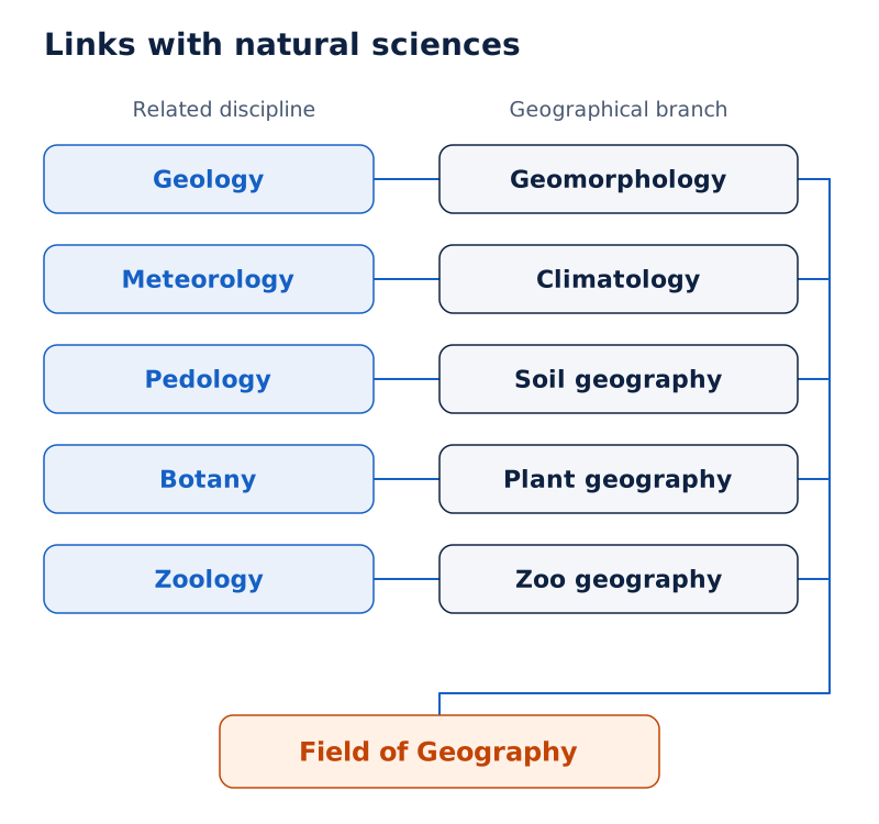
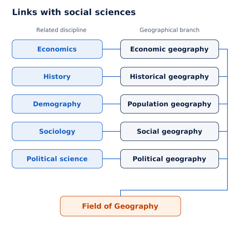
An oval labelled Field of Geography is surrounded by overlapping circles. These pair related disciplines with geographical branches, including geology with geomorphology, meteorology with climatology, pedology with soil geography, economics with economic geography and history with historical geography.
Drawn by One Young India. See Fig. 1.1 in your NCERT textbook
| Related discipline | Geographical branch shown |
|---|---|
| Demography | Population geography |
| Sociology | Social geography |
| Political science | Political geography |
| Botany | Plant geography |
| Zoology | Zoo geography |
Improved transport increases accessibility between places. Audio-visual media and information technology expand the available information and support the monitoring of natural, economic and social phenomena. These connections help explain the idea of the world as a global village.
Case study: How have India's geographical features influenced its history?
The Himalayas acted as barriers and offered protection, while their passes provided routes for migrants and invaders from Central Asia. Thus, the same broad physical setting included both barriers and routes of movement.
India's sea coast encouraged contact with people from East and Southeast Asia, Europe and Africa. Navigation technology gave European countries access through the oceans and helped them colonise countries in Asia and Africa, including India.
This example links physical geography, movement, technology and historical events. It illustrates why history and geography are closely connected: geographical conditions influence events, while historical processes contribute to the changing organisation of space.
How do systematic and regional approaches differ?
Origins of the approaches
The major approaches to geographical study are systematic geography and regional geography. The systematic approach studies a phenomenon across the world. The regional approach studies the geographical phenomena of a selected region together.
| Scholar | Dates | Contribution |
|---|---|---|
| Eratosthenese | 276 to 194 BC | Coined the term geography. |
| Alexander Von Humboldt | 1769 to 1859 | Introduced the systematic approach. |
| Karl Ritter | 1779 to 1859 | Developed the regional approach. |
Humboldt and Ritter were German geographers and contemporaries. Their approaches offer different starting points for geographical study. One begins with a phenomenon and examines its spatial patterns; the other begins with a region and examines its phenomena holistically.
How does the systematic approach study vegetation?
The study of natural vegetation illustrates the systematic approach. It begins at the world level and proceeds to the identification, discussion and delimitation of types. The approach can be followed through these connected steps:
- Study natural vegetation across the world as a whole.
- Identify types such as equatorial rain forests, softwood conical forests and monsoon forests.
- Discuss the identified vegetation types as part of the study.
- Delimit the types to establish their spatial patterns.
How does the regional approach organise study?
In the regional approach, the world is divided into regions at different hierarchical levels. Regions may be natural, political or designated. All geographical phenomena within a selected region are then studied together, seeking unity in diversity.
The approaches differ in focus, but both address spatial relationships. Studying a phenomenon across the world helps identify types and patterns. Studying a region brings different phenomena together to understand their association within that area.
Geography also has a long-standing dualism between emphasis on physical features and emphasis on human activities. Human geography developed because people are part of nature and contribute to the earth's surface through cultural development. Both physical and human aspects are necessary to its scope.
What do physical geography and biogeography study?
Branches of physical geography
Physical geography studies landforms, the atmosphere, water and soils. Its branches focus on different parts of the physical environment and the processes through which they develop. These fields also help explain the environmental conditions affecting human activities.
| Branch | Scope of study |
|---|---|
| Geomorphology | Landforms, their evolution and the processes associated with them. |
| Climatology | Atmospheric structure, elements of weather and climate, and climatic types and regions. |
| Hydrology | Water over the earth's surface, including oceans, lakes and rivers, and its effects on life and human activities. |
| Soil geography | Soil formation, soil types, fertility status, distribution and use. |
The branches distinguish particular subjects while remaining connected within physical geography. For example, studying soils includes their formation and fertility, while studying water includes its effects on living organisms and human activities. Their scope includes both physical characteristics and relationships.
Biogeography as an interface
Biogeography develops at the interface of physical and human geography. It includes the study of plants, animals, habitats and environmental concerns. Its branches connect geographical distributions with the conditions in which organisms live.
- Plant geography studies the spatial patterns of natural vegetation in its habitats.
- Zoo geography studies the spatial patterns and geographical characteristics of animals and their habitats.
- Ecology concerns the scientific study of habitats characteristic of species.
- Environmental geography addresses environmental problems, including pollution, and concerns for conservation.
What the figure shows
Branches of geography based on systematic approach
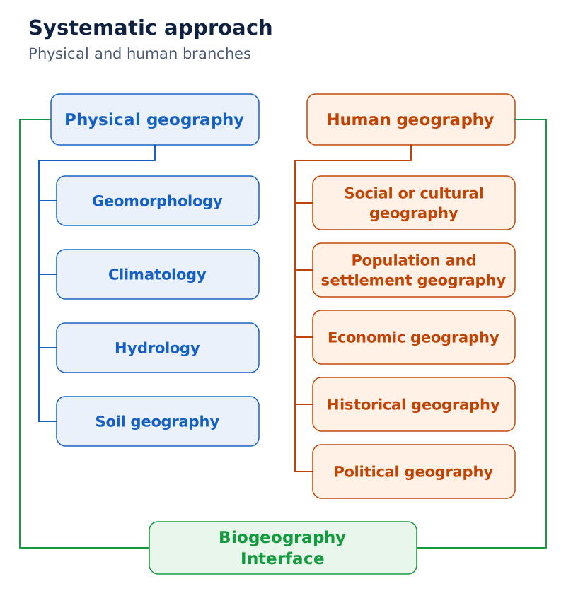
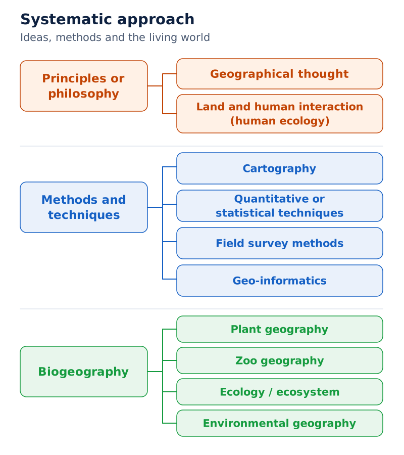
A branching chart places physical geography, principles or philosophy, methods and techniques, and human geography beneath the main heading. A central box labels biogeography as an interface. Lower boxes show branches such as geomorphology, climatology, hydrology, soil geography, plant geography and zoo geography.
Drawn by One Young India. See Fig. 1.2 in your NCERT textbook
The chart also places philosophy and methods within the wider organisation of geography. This reminds us that geographical study involves ways of thinking and investigating as well as the physical and human features being studied.
Which subjects are included in human and regional geography?
Branches of human geography
Human geography emphasises human activities and their spatial relationships. It studies society, culture, population, settlements, economic activity, historical processes and political relationships. These branches help explain how people contribute to the organisation and transformation of space.
| Branch | Main concerns |
|---|---|
| Social or cultural geography | Society, its spatial dynamics and the cultural elements it contributes. |
| Population and settlement geography | Population growth, distribution, density, sex ratio, migration and occupational structure; characteristics of rural and urban settlements. |
| Economic geography | Agriculture, industry, tourism, trade, transport, infrastructure and services. |
| Historical geography | Historical processes through which space becomes organised and geographical features change over time. |
| Political geography | Boundaries, relations between neighbouring political units, constituency delimitation, elections and political behaviour. |
Population geography and settlement geography have related but distinct concerns. The former examines population characteristics and changes. The latter examines rural and urban settlements. Economic geography considers activities through which people produce, exchange and provide goods and services.
Historical geography brings temporal change into geographical explanation. Political geography examines space through political events and relationships. These branches show that the organisation of space involves social processes as well as physical conditions.
Branches based on the regional approach
Regional studies, or area studies, include macro, meso and micro regional studies. The other main branches are regional planning, regional development and regional analysis. Regional planning includes country or rural planning and town or urban planning.
What the figure shows
Branches of geography based on regional approach
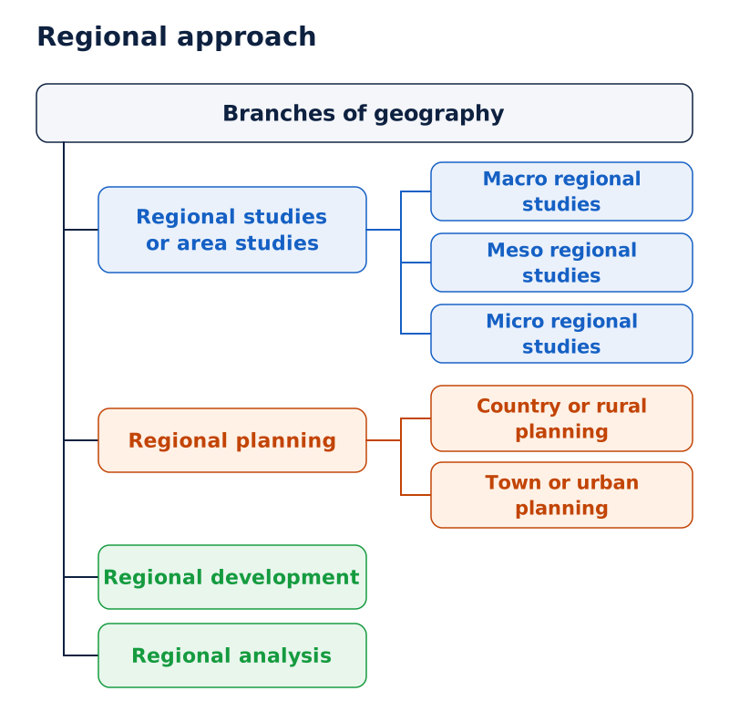
The top box branches into regional studies or area studies, regional development, regional analysis and regional planning. Area studies divide into macro, meso and micro regional studies. Planning divides into country or rural planning and town or urban planning.
Drawn by One Young India. See Fig. 1.3 in your NCERT textbook
This classification organises study around regions and their development, analysis and planning. It differs from a classification that begins with separate phenomena such as climate or population. The regional approach brings geographical features together within an area.
How do geographical philosophy, methods and technology support study?
Ideas and practical investigation
Philosophy and methods and techniques are aspects shared by disciplines. In geography, philosophy includes geographical thought and the study of land and human interaction, also described as human ecology. These concerns provide the intellectual basis for understanding geographical relationships.
Methods and techniques include cartography, quantitative or statistical techniques, field survey methods and geo-informatics. They provide different ways to represent, investigate and analyse the features and relationships with which geography is concerned.
- Cartography includes both map-making and computer cartography.
- Quantitative techniques include statistical techniques used in geographical study.
- Field survey methods form part of geographical investigation.
- Geo-informatics includes techniques such as remote sensing, GIS and GPS.
How has technology changed geographical work?
Manual cartography has developed into computer cartography. Technology enables scholars to handle large quantities of data, while the internet provides extensive information. These developments have greatly increased the capacity for geographical analysis.
GIS has opened further possibilities for geographical knowledge. GPS helps identify exact locations. These technologies strengthen the ability to study spatial information, but effective synthesis also depends on sound theoretical understanding of the phenomena being analysed.
Improved techniques also support the monitoring of natural phenomena and economic and social conditions. This connects the collection and analysis of information with geography's wider task of understanding relationships among physical and human features.
Note: The classification of geography's branches is not fixed. New ideas, problems, methods and techniques contribute to the continuing development of the discipline.
The relationship between methods and ideas is therefore important. Tools expand the information that can be handled and the analysis that can be attempted. Geographical understanding brings that information together into an explanation of spatial patterns and interrelationships.
Why is physical geography important for resources and development?
The physical environment and human activities
Physical geography covers the lithosphere, atmosphere, hydrosphere and biosphere. These include landforms and drainage; air and weather; oceans, seas and lakes; and life forms with their sustaining relationships. Each part matters for human activities and resource use.
Landforms provide the base for human activities. Plains support agriculture. Plateaus provide forests and minerals. Mountains provide pastures, forests and tourist locations, and are sources of rivers that supply water to lowlands.
Climate influences house types, clothing and food habits. It also affects vegetation, cropping patterns, livestock farming and some industries. Temperature and precipitation influence forest density and grassland quality. Air conditioners and coolers modify climatic conditions within restricted spaces.
In India, monsoonal rainfall sets the rhythm of agriculture. Precipitation recharges groundwater aquifers, which later supply water for agriculture and domestic use. These relationships connect atmospheric conditions, water availability and human needs.
Oceans provide fish, other seafood and minerals. India has developed technology to collect manganese nodules from the ocean bed. Studying the water realm therefore includes understanding its resources as well as its physical features.
Soils, ecological balance and sustainability
Pedogenesis is the process of soil formation. Soils depend on parent rocks, climate, biological activity and time. Time allows soils to mature and soil profiles to develop. Their fertility is influenced by natural conditions and human activity.
Soils are renewable resources that support agriculture and other economic activities. They also provide a basis for plants, animals and microorganisms. Their importance connects resource use with the life forms that make up the biosphere.
Physical geography contributes to evaluating and managing natural resources. Modern technology has accelerated resource use and contributed to ecological imbalance. Understanding the relationship between people and the physical environment is therefore essential for sustainable development.
Resources support economic and cultural development, but their use affects the environment. Physical geography helps bring these connections into view by studying the physical conditions that sustain life alongside human dependence on, and modification of, those conditions.
Glossary
- Geography — Study of the earth's physical and human phenomena, their spatial differences and their interrelationships.
- Areal differentiation — Variation in physical and cultural phenomena across different parts of the earth's surface.
- Spatial synthesis — Bringing related phenomena together to understand their associations within geographical space.
- Temporal synthesis — Bringing events and changes together through time, an approach associated with history.
- Systematic geography — Approach studying a phenomenon worldwide before identifying and examining its types and spatial patterns.
- Regional geography — Approach studying geographical phenomena together within regions at different hierarchical levels.
- Geomorphology — Branch of physical geography studying landforms, their evolution and the processes associated with them.
- Climatology — Study of atmospheric structure, weather and climate elements, and climatic types and regions.
- Hydrology — Study of the earth's surface water and its effects on life forms and human activities.
- Soil geography — Study of soil formation, soil types, fertility status, distribution and use.
- Biogeography — Field at the interface of physical and human geography, including plant, animal, ecological and environmental studies.
- Human ecology — Study of land and human interaction within the philosophical concerns of geography.
- Pedogenesis — Process of soil formation involving parent rocks, climate, biological activity and time.
- Spatial integration — Linking places through connections such as transport and communication networks across geographical space.
Common errors and misconceptions
- Misconception: Geography is simply the memorisation of places. Correct: It identifies and locates phenomena, but also explains their causes, relationships and changing spatial patterns.
- Misconception: Geography studies physical features alone. Correct: It includes human activities and cultural features, together with their interaction with the physical environment.
- Misconception: Areal differentiation means listing differences without explaining them. Correct: Geography examines associations and causes, such as the physical and human factors linked with cropping patterns.
- Misconception: Human beings are separate from nature. Correct: People are part of nature, adapt to it and modify it through their activities and technology.
- Misconception: Systematic and regional geography have the same starting point. Correct: Systematic study starts with a phenomenon across the world; regional study brings phenomena together within a region.
- Misconception: Time belongs to history and has no place in geography. Correct: Geographical phenomena change through time, which is treated as the fourth dimension of geographical study.
- Misconception: Technology makes environmental understanding unnecessary. Correct: Technology expands human possibilities, but accelerated resource use can create ecological imbalance, making environmental understanding essential.
Exam-style questions with model answers
Q1. Explain the origin of the term geography. [2 marks]
- The term combines the Greek roots geo, meaning earth, and graphos, meaning description. Together they express the description of the earth.
- Eratosthenese, a Greek scholar, first coined the term geography.
Q2. Explain the three main questions asked in geography. [3 marks]
- What identifies natural and cultural features and the patterns they form over the earth's surface.
- Where concerns their distribution and location. Together, what and where provide an inventory of features and places.
- Why explains causal relationships between features, processes and phenomena. It adds the explanatory element needed to understand spatial patterns rather than merely identify and locate them.
Q3. Use cropping patterns to explain areal differentiation. [3 marks]
- Areal differentiation means variation in phenomena from one part of the earth's surface to another. Regional differences in cropping patterns illustrate this concept.
- These differences are associated with soils, climate, market demand, farmers' investment capacity and available technological inputs.
- A geographical explanation connects these physical and human factors. It does more than list different patterns: it examines the relationships associated with their variation across regions.
Q4. Distinguish between systematic and regional approaches to geography. [5 marks]
- The systematic approach studies a phenomenon across the world as a whole, then identifies its types and spatial patterns. Alexander Von Humboldt introduced this approach.
- For natural vegetation, systematic study begins at the world level. It identifies, discusses and delimits types such as equatorial rain forests, softwood conical forests and monsoon forests.
- The regional approach divides the world into regions at different hierarchical levels. Karl Ritter developed this approach.
- Regions may be natural, political or designated. Their geographical phenomena are studied together in a holistic manner, seeking unity in diversity.
- The distinction is therefore between beginning with a phenomenon worldwide and beginning with a region whose phenomena are studied together.
Q5. Explain why geography is an integrating discipline. [5 marks]
- Geography draws information from natural and social sciences and combines it through a spatial perspective. It seeks relationships among phenomena rather than treating each feature in isolation.
- Its approach is holistic because the world contains interdependent elements. Geography attempts spatial synthesis, while history attempts temporal synthesis.
- Connections include geology with geomorphology, meteorology with climatology, pedology with soil geography, and economics with economic geography.
- India illustrates the connection with history. The Himalayas provided protection, but their passes also offered routes for migrants and invaders from Central Asia.
- Coastal contacts and navigation technology further connected physical settings with historical processes. Such examples show why a geographical explanation brings several fields of knowledge together.
Q6. Describe the four main branches of physical geography. [4 marks]
- Geomorphology studies landforms, their evolution and related processes.
- Climatology studies atmospheric structure, weather and climate elements, and climatic types and regions.
- Hydrology studies surface water, including oceans, lakes and rivers, and its effects on life forms and human activities.
- Soil geography studies soil formation, types, fertility status, distribution and use. Together these branches examine major parts of the physical environment and the processes associated with them.
Q7. Explain the importance of physical geography for human activities and sustainable development. [5 marks]
- Landforms provide the base for human activities. Plains support agriculture, plateaus provide forests and minerals, and mountains provide pastures, forests, tourist locations and river sources.
- Climate influences houses, clothing, food habits, vegetation, cropping patterns, livestock farming and some industries. In India, monsoonal rainfall sets the agricultural rhythm.
- Precipitation recharges groundwater aquifers used for agriculture and domestic purposes. Oceans supply food and mineral resources.
- Soils support agriculture and provide a basis for plants, animals and microorganisms. Their formation depends on parent rocks, climate, biological activity and time.
- Accelerated resource use through modern technology has created ecological imbalance. Understanding physical environments helps evaluate and manage natural resources and is essential for sustainable development.
Key takeaways
- Geography examines physical and human phenomena, their spatial variation, their relationships and their changes through time.
- Areal differentiation involves differences between places; geographical explanation investigates the factors and relationships associated with those differences.
- The questions what, where and why connect identification and location with the explanation of geographical patterns.
- Human beings belong to nature and interact with it through adaptation, technological development and environmental modification.
- Geography integrates natural and social sciences through spatial synthesis, while history brings events together through temporal synthesis.
- Systematic geography begins with a phenomenon worldwide; regional geography studies phenomena together within a selected region.
- Geographical branches develop as new ideas, problems, methods and technologies expand the scope of the discipline.
- Physical geography supports understanding and management of resources, making it essential for addressing ecological imbalance and sustainable development.
Test yourself
Which question gives geographical enquiry its causal focus?
The question why seeks explanations for features, processes and relationships, adding a causal focus to geographical enquiry.
What physical and human factors are associated with cropping patterns?
They include soils, climates, market demand, farmers' capacity to invest and the technological inputs available to them.
What are links and nodes in spatial organisation?
Links are routes, while nodes are settlements of different types and levels. Transport and communication networks connect them and integrate space.
Who introduced the systematic approach and who developed the regional approach?
Alexander Von Humboldt introduced the systematic approach, while his contemporary Karl Ritter developed the regional approach.
Which branches belong to biogeography?
Biogeography includes plant geography, zoo geography, ecology or ecosystem studies, and environmental geography.
What are the main branches based on the regional approach?
They are regional or area studies, regional planning, regional development and regional analysis.
What does pedogenesis mean, and which factors influence it?
Pedogenesis means soil formation. Soils depend on parent rocks, climate, biological activity and time, which supports maturity and soil profile development.
Why does improved technology increase the need to understand the physical environment?
Modern technology accelerates resource use, which can create ecological imbalance. Environmental understanding is essential for managing resources and pursuing sustainable development.