
Transport | ICSE Class 10 Geography Notes
On this page
Watch & explore
Start with a few high-quality watches, then dive into the notes below.
Try an idea before you read. Step into the shoes of a logistics planner and navigate India's transport network! Explore →

This note covers the importance of transport, factors affecting road and railway development, expressways, National Highways, the Golden Quadrilateral, the North-South and East-West Corridors, inland and coastal waterways, airways, and the advantages and disadvantages of each major mode.
What is transport, and why is it important?
Definition: Transport is a service for carrying people and goods from one place to another, using people, animals or vehicles. Its main domains are land, water and air.
Production and consumption often take place in different locations. Fields, factories and markets need connections so that goods can reach the people who use them. Transport provides these connections and makes products available beyond their places of production.
Freight means goods carried by a transport service, as distinct from passengers. Food, clothes and other everyday requirements reach markets through transport. A country's development therefore depends on both the production of goods and their movement between places.
How do different modes work together?
A mode of transport is a means of moving people or goods. Roadways and railways operate on land, waterways use water routes, and airways use aircraft. An airport provides facilities for aircraft to land and operate; a seaport provides facilities for vessels to load and unload. Their usefulness depends on the goods, the distance, the cost and the available services.
| Mode | Particular strength | Connection with other modes |
|---|---|---|
| Roadways | Short journeys and delivery directly between premises | Link settlements with railway stations, airports and seaports |
| Railways | Large quantities of bulky goods over long inland distances | Combine with roads for collecting and distributing goods |
| Waterways | Heavy and bulky cargo carried at low cost | Use ports where goods can be transferred |
| Airways | Rapid movement of passengers and high-value, light or perishable goods | Use airports linked to other transport services |
Perishable goods are goods liable to spoil, making the time taken in transport important. A fast mode may suit these goods, while a cheaper mode may be better for bulky material. No single mode meets every transport requirement equally well.
How does a network support national life?
A transport network consists of places joined by routes. The places are called nodes, and the routes connecting them are links. Efficient networks help trade, agriculture, industry, tourism and defence, while bringing people in different regions into contact.
Transport, communication and trade are complementary: each supports the others. Transport carries goods and people; communication exchanges information; trade exchanges goods and services. Their combined development connects local, national and international markets.
Which factors affect the development of roadways?
Road development depends on physical conditions, demand for movement, finance and public planning. The same road design cannot be applied equally easily to level plains, steep mountains, forests and flood-prone areas. Construction and maintenance must respond to the terrain.
How do relief and weather affect roads?
Relief means the differences in height and shape of the land. Roads can cross comparatively more dissected and undulating topography than railways. Here, dissected topography means land cut by valleys, while undulating land has alternating rises and hollows.
A gradient is the steepness of a slope. Roads can negotiate higher gradients than railway lines, helping them cross mountains such as the Himalayas. This advantage does not remove the difficulty or expense of building in mountainous terrain.
Metalled roads have a durable surface made with materials such as cement, concrete or bitumen. They are classified as all-weather roads. Unmetalled roads lack this durable surfacing and become unmotorable during the rainy season.
Heavy rain and floods can seriously hamper even metalled roads. In high mountain areas, snowfall can interrupt traffic and make snow clearance necessary. Thus, a road's surface and the weather both affect the reliability of movement.
How do demand, investment and policy matter?
Road construction and maintenance require substantial expenditure. Roads have concentrated in and around urban centres, while rural and remote areas have had poorer connectivity. The nature of the terrain also influences regional differences in rural road density, meaning road length relative to area.
The Nagpur Plan of 1943 was an early serious attempt at road development, but lack of coordination between princely states and British India prevented its implementation. After Independence, a twenty-year road plan was introduced in 1961 to improve road conditions.
The Border Roads Organisation, established in May 1960, develops strategically important routes along the northern and north-eastern boundaries. Its work supports defence and economic development. It also clears snow in high-altitude areas, showing that maintaining access matters alongside building roads.
How does the Atal Tunnel improve access?
The Atal Tunnel, built by the Border Roads Organisation, is 9.02 kilometres long. It links Manali with the Lahaul-Spiti valley throughout the year. Previously, heavy snowfall cut off the valley for about six months each year.
The tunnel lies in the Pir Panjal range of the Himalayas at an altitude of 3,000 metres above mean sea level. Mean sea level is the average sea level used as a reference for measuring altitude, or height.
This example connects a physical obstacle with an engineering response: heavy mountain snowfall restricted access, while the tunnel provided an all-year link. The continuing need for snow clearance on high-altitude roads also shows why construction and maintenance must be considered together.
Note: An all-weather surface does not make a route immune to heavy floods or snowfall. Distinguish the normal serviceability of a metalled road from exceptional conditions that can interrupt traffic.
What are the advantages and disadvantages of road transport?
Road transport is particularly useful when a small number of people or a relatively small quantity of goods must move over a short distance. Its value comes from accessibility, comparatively low construction costs and its ability to connect with other modes.
What gives roads an advantage?
- Lower construction cost: Building roads costs much less than constructing railway lines. This makes roads an important means of extending surface transport.
- Adaptation to relief: Roads can negotiate higher gradients and comparatively more uneven terrain than railways, including mountain routes.
- Short-distance economy: They are economical for carrying a few passengers or relatively small loads over short distances.
- Door-to-door service: Goods can travel directly between the premises where they are collected and delivered, reducing loading and unloading costs.
- Feeder service: Roads provide the connecting journeys to railway stations, airports and seaports. A feeder service brings traffic to another transport service.
The last two advantages explain why roads remain important even where railways or waterways carry the main long-distance load. A railway station or seaport still needs connections with the surrounding settlements and production areas.
What limits road transport?
Congestion occurs when traffic demand exceeds what the road network can accommodate. City roads experience heavy traffic, particularly before and after working hours. A route may exist but still fail to provide quick movement when it is overcrowded.
Unmetalled roads become unmotorable during the rainy season. Heavy rainfall and floods can also seriously hamper metalled roads. Mountain routes need maintenance under difficult conditions, including snow clearance in high-altitude areas.
Lower construction cost than railways does not mean that roads are cheap to maintain in every setting. Quality roads still need substantial expenditure. Moreover, the short-distance economy of roads should not be extended into a claim that they are the best mode for every load and distance.
| Transport requirement | Comparison |
|---|---|
| A small load over a short distance | Road transport is economical and provides direct delivery. |
| Large volumes of bulky material over a long inland distance | Railways are particularly suitable for this movement. |
| A link between a settlement and a station or port | Roads provide the feeder connection to the main service. |
What are expressways and National Highways?
Expressways are major roads designed for speedy, uninterrupted movement of motor traffic. Separate traffic lanes and divided carriageways help movement in opposite directions. A carriageway is the part of a road used by vehicles.
National Highways form the country's primary road system. They connect distant parts of India, state capitals, major cities, important ports and railway junctions. Their role includes inter-state transport and the movement of defence personnel and materials in strategic areas.
What is the importance of major road links?
Long-distance road links connect important centres of production and consumption. Improving these routes can reduce the time and cost of movement. The importance of a highway therefore lies in what it connects and how effectively it carries traffic.
The National Highways Authority of India, abbreviated as NHAI, was operationalised in 1995. It is responsible for developing, maintaining and operating National Highways entrusted to it, and for improving the quality of these routes.
Photograph: Ahmedabad-Vadodara Expressway. The photograph shows separate paved carriageways divided by a central strip, marked lanes, rows of light poles and vehicles on the road. It illustrates the physical layout of an expressway.
How do other roads connect with this system?
| Road category | Main connection or purpose |
|---|---|
| National Highways | Connect distant parts of the country and major centres. |
| State Highways | Join state capitals with district headquarters and other important towns; connect with National Highways. |
| District roads | Connect district headquarters with other important places in the district. |
| Rural roads | Link villages and rural areas with towns. |
| Border roads | Improve access in border areas and support defence and economic development. |
The Pradhan Mantri Grameen Sadak Yojana is a rural road scheme providing for all-season motorable links between villages and major towns. Such connecting roads help extend the benefits of larger transport routes into rural areas.
The Bharatmala Pariyojana, in its December 2021 programme description, envisaged about 26,000 kilometres of economic corridors. Together with the Golden Quadrilateral and North-South and East-West (NSEW) Corridors, these were expected to carry the majority of road freight traffic.
The programme also focused on ring roads, bypasses and elevated corridors to relieve traffic passing through cities. These are routes around cities, around congested sections, or above ground level, respectively. Their purpose is to improve the efficiency of goods movement.
Road categories based on purpose should be distinguished from classification by surface. “National Highway” identifies a road's role in the network, while “metalled” identifies its construction surface. These descriptions answer different questions about the same road.
How do the Golden Quadrilateral and the NSEW Corridors improve connectivity?
A transport corridor is a major route connecting important places and carrying substantial traffic. A metropolitan city is a major urban centre. The Golden Quadrilateral links Delhi, Mumbai, Chennai and Kolkata. The North-South and East-West Corridors, abbreviated as NSEW Corridors, extend connections along the country's two main directions.
Case study: How does the Golden Quadrilateral connect metropolitan centres?
The Golden Quadrilateral comprises a 5,846-kilometre high-density traffic corridor connecting the four metropolitan cities. A kilometre, written as km, is a unit of distance. The project provides four-lane or six-lane roads along this major network.
Its purpose is to reduce the time, distance and cost of movement between the cities. Connecting these centres is important because transport supports exchanges between production areas and markets. The four-city circuit differs from a single route joining opposite ends of India.
A spur is a branch from a main route. It forms part of the North-South project listed below.
| Project | Places connected | Project length |
|---|---|---|
| Golden Quadrilateral | Delhi, Mumbai, Chennai and Kolkata | 5,846 km |
| North-South Corridor | Srinagar to Kanniyakumari, including the Cochin-Salem spur | 4,076 km |
| East-West Corridor | Silchar in Assam to Porbandar in Gujarat | 3,640 km |
The Cochin-Salem spur is included in the stated North-South project length. These figures describe the projects; they are not straight-line distances between the named endpoints.
How does better connectivity support movement?
- Major centres and distant regions are joined by high-capacity road links.
- Improved routes aim to reduce the time and distance involved in movement.
- Lower movement costs improve the connections between places supplying goods and places demanding them.
- Feeder roads connect the major routes with towns, villages, stations and ports, allowing the modes to complement one another.
What the figure shows
India, National Highways
The map distinguishes the North-South Corridor in red, the East-West Corridor in grey and the Golden Quadrilateral in yellow. Its legend also identifies numbered National Highways. Trace the four-city circuit separately from the two cross-country corridors.
Which factors influence the distribution of railways?
Railways carry passengers and freight along railway tracks. The distribution of India's network has been largely influenced by physical, economic and administrative factors. Level land makes construction easier, while population and productive activity generate demand for railway services.
Why are the northern plains favourable?
The northern plains combine extensive level land, high population density and rich agricultural resources. These conditions provide both favourable construction terrain and substantial demand for movement. Agricultural production and large populations help explain the importance of railway connections there.
However, the northern plains are not free from obstacles. Their many rivers require bridges across wide river beds. Thus, an area may be favourable overall while still presenting important engineering challenges along individual routes.
Why is construction more difficult elsewhere?
| Region or physical setting | Influence on railway development |
|---|---|
| Northern plains | Level land, dense population and agricultural resources favour growth; wide river beds require bridges. |
| Hilly parts of the peninsula | Routes pass through low hills and gaps, or use tunnels. |
| Himalayan mountains | High relief, sparse population and lack of economic opportunities make construction unfavourable. |
| Western Rajasthan | Sandy plains make the laying of railway lines difficult. |
| Swamps of Gujarat | Waterlogged ground presents difficulties for laying tracks. |
| Forested parts of central and eastern India | Forested tracts in Madhya Pradesh, Chhattisgarh, Odisha and Jharkhand have presented construction difficulties. |
In the Sahyadri, the continuous mountain barrier could be crossed through gaps or passes. A pass is a route through a gap in a mountain barrier. Tunnels and bridges allow railways to overcome some obstacles, but add engineering requirements.
How have economic and administrative decisions shaped the network?
During British rule, railways connected towns, raw-material areas, plantations, commercial crop regions, hill stations and cantonment towns. Cantonments are military stations. These connections were mostly developed for the exploitation of resources. Routes were extended to other areas after Independence.
The network remains relatively less dense in hill states, north-eastern states, central India and Rajasthan. Railway distribution therefore reflects both the physical difficulty of laying tracks and historical decisions about which places and economic activities to connect.
What are the advantages and disadvantages of rail transport?
Rail transport is particularly suited to large volumes of bulky material over long distances within a country. It also carries passengers travelling for work, business, sightseeing and pilgrimage. Railways connect regions and support the development of agriculture and industry.
What are its main advantages?
Railways combine long-distance passenger movement with the carriage of substantial freight. They help bind the economic life of the country together and bring people from different regions into contact. Commuter trains carry people making regular journeys within urban areas.
India's first train ran from Mumbai to Thane in 1853, covering 34 km. The subsequent development of the network made railways an important integrating force, supporting exchanges across regions as well as the movement of goods.
What difficulties limit railways?
Railway construction costs more than road construction. Mountain barriers require suitable gaps, tunnels and bridges, while high relief and sparse population can make development unfavourable. Roads provide the feeder links between stations and the places where journeys begin or goods are delivered.
Railways also face operational problems. Many passengers travel without tickets. Theft and damage to railway property have not yet stopped completely. Unnecessary chain-pulling and stopping of trains interfere with railway services and cause damage.
Case study: What does the Konkan Railway show?
The Konkan Railway, constructed in 1998, is a 760-kilometre route between Roha in Maharashtra and Mangalore in Karnataka. Maharashtra, Goa and Karnataka are partners in the undertaking. It provides an important link along India's western coast.
The route crosses 146 rivers and streams, nearly 2,000 bridges and 91 tunnels. A tunnel nearly 6.5 kilometres long lies along the route. These features show the scale of engineering needed to create a railway connection across difficult terrain.
The railway has facilitated the movement of passengers and goods in this important economic region. At the same time, it has faced sinking tracks in some stretches and landslides. A landslide is the movement of rock or earth down a slope.
Note: The Konkan Railway illustrates both improved access and continuing physical difficulties. Its benefits do not mean that construction has removed every maintenance problem along the route.
How do inland waterways work, and what are their advantages and limitations?
Inland waterways are transport routes using rivers, canals, lakes and related inland water channels. Boats and steamers carry passengers and cargo. India has 14,500 kilometres of navigable waterways. These include rivers, canals and backwaters, the inland coastal waters connected behind the shoreline.
Navigability means suitability for the passage of boats or ships. It depends on channel width and depth, continuity of water flow and the transport technology in use. The presence of a river does not by itself establish that it can carry substantial commercial traffic.
Why is inland water transport useful?
Waterways are the cheapest means of transport and are most suitable for heavy and bulky goods. They are fuel-efficient and environment friendly. Cargo such as coal, cement, timber and metallic ores can be carried on inland waterways.
Natural water routes do not require the construction of a continuous road or railway track. However, navigation and the handling of goods still require facilities. Developing water transport therefore involves more than identifying a river on a map.
What are its disadvantages?
Insufficient depth or width and interruptions in water flow limit navigation. Diversion of river water for irrigation has made large parts of some river courses non-navigable. Inland waterways have also faced competition from roads and railways, together with poor maintenance.
Dredging means removing deposited material from a channel to improve its depth. Dredging, stabilising banks and regulating flow with dams or barrages can improve navigability. These requirements explain why natural waterways may still need investment and maintenance.
Which National Waterways illustrate the system?
The Inland Waterways Authority was established in 1986 for the development, maintenance and regulation of National Waterways. The National Waterways Act, 2016 declared 111 inland waterways as National Waterways, including five declared earlier. “NW” below means National Waterway. The table describes the five earlier waterways included in that declaration.
| Waterway | Route | Length |
|---|---|---|
| NW 1 | Ganga: Prayagraj to Haldia | 1,620 km |
| NW 2 | Brahmaputra: Sadiya to Dhubri | 891 km |
| NW 3 | West Coast Canal: Kottapuram to Kollam, with Udyogamandal and Champakara canals | 205 km |
| NW 4 | Specified Godavari and Krishna stretches with the Kakinada-Puducherry canal stretch | 1,078 km |
| NW 5 | Specified Brahmani stretches, Matai river, Mahanadi and Brahmani delta channels, and East Coast Canal | 588 km |
NW 3 includes 168 kilometres of the West Coast Canal, 14 kilometres of Champakara Canal and 23 kilometres of Udyogamandal Canal. Kerala's backwaters provide cheap transport and attract tourists.
What the figure shows
National Waterway No. 3
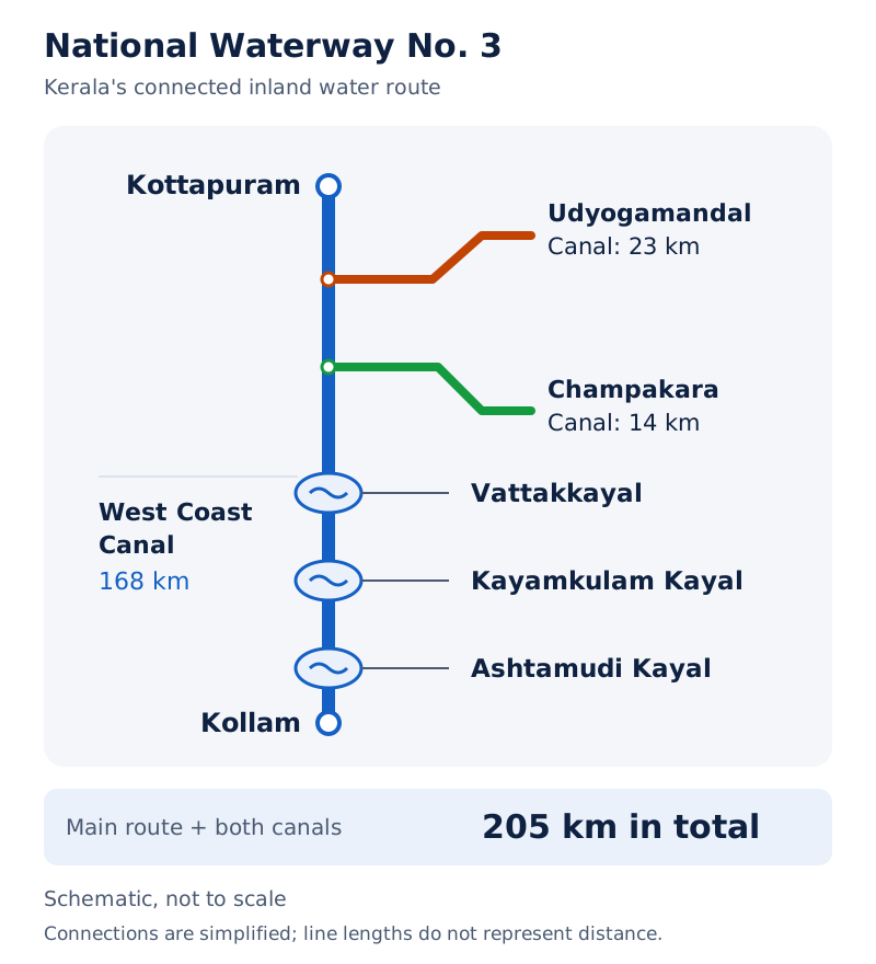
The figure combines a photograph of long rowing boats with a map of the Kerala waterway. The map labels Kottapuram, Kollam, the two connecting canals and several intervening water bodies; it is marked “Not to Scale”.
Drawn by One Young India.
What is coastal shipping, and how does it differ from inland navigation?
Coastal shipping carries goods or passengers between places along a sea coast. Inland navigation uses inland water channels, whereas coastal vessels move through coastal waters between ports. Both belong to water transport, but their routes and facilities differ.
Why is coastal shipping useful for India?
A long coastline makes coastal shipping a convenient mode of transport. Water transport is cheaper for bulky loads, and properly developed coastal shipping can reduce congestion on land routes. This benefit depends on developing the service and its connections effectively.
Sea routes also link islands with the rest of the country. Overseas shipping connects different countries, so it should be distinguished from movement along a country's coast. India's ports support both wider sea trade and links with inland production and consumption areas.
A seaport is one type of port; ports can also lie inland on rivers. A harbour provides sheltered water for vessels. The hinterland of a port is the inland area it serves through transport and trade connections.
What limitations require attention?
Sea routes require port facilities at their ends. Coastal shipping also depends on connections between ports and inland places. It therefore complements land transport: a sea journey does not remove the need to collect and distribute goods inland.
Some ports need continuing work to maintain access. The Kolkata port is an inland riverine port serving the Ganga-Brahmaputra basin. Its tidal setting requires constant dredging of the Hooghly. Haldia developed as a subsidiary port to relieve pressure on Kolkata.
Mumbai has a spacious natural, well-sheltered harbour. Jawaharlal Nehru Port was planned to reduce pressure on Mumbai and serve as a regional hub. These examples show that sheltered water, facilities and handling capacity matter alongside a port's coastal location.
What the figure shows
India, Major Ports and Some International Airports
The map uses different symbols for seaports and airports. It marks Mumbai, Mormugao, New Mangalore and Cochin on the western side, and Chennai, Vishakhapatnam, Paradwip and the Kolkata-Haldia area on the eastern side.
What are the advantages and disadvantages of air transport?
Air transport is the fastest means of transport. It reduces journey time across long distances and can cross mountains, deserts, dense forests and extensive ocean stretches. It is particularly important where surface travel is difficult or places are inaccessible.
Why are airways valuable in difficult terrain?
North-eastern India has large rivers, dissected relief, dense forests and frequent floods. Air travel has made access easier in this region. Aircraft can connect places without following the long surface routes required to cross these physical barriers.
In the Himalayas, surface routes are often obstructed by landslides, avalanches or heavy snowfall. An avalanche is a mass of snow moving down a mountain slope. At such times, air travel is the only alternative for reaching a place cut off by these obstructions.
Air transport is often the only means of reaching inaccessible areas. It also suits high-value, light and perishable goods because they can be moved rapidly. Speed is therefore an economic advantage for some cargo as well as a convenience for passengers.
What are the main disadvantages?
Air transport is very costly. Aircraft manufacture and operation require extensive facilities for landing, fuelling, maintenance and storage. A hangar is a building used to house aircraft. The construction of airports is also very expensive.
These requirements limit the usefulness of air transport as a low-cost general carrier. Its speed must be considered alongside its expense and the nature of the load. Railways and waterways remain particularly suitable for large quantities of bulky goods.
How have services extended access?
Air transport in India began in 1911 with airmail over the 10-kilometre distance between Prayagraj and Naini. Its substantial development followed Independence. Pawan Hans provides helicopter services in difficult terrain and for petroleum-sector operations, including offshore operations at sea.
UDAN, meaning Ude Desh ka Aam Nagrik, is a regional connectivity scheme intended to make flying affordable for the common citizen. It encourages airlines to operate on regional and remote routes through supporting policies and incentives.
The comparison between airways and surface modes depends on the purpose of the journey. Fast access to a remote place and cheap carriage of a heavy bulk load are different requirements, so the most suitable modes can differ.
Glossary
- Transport — A service that carries people and goods between places using people, animals or vehicles.
- Freight — Goods carried by a transport service, distinguished from the passengers using that service.
- Transport network — A pattern of places connected to one another by a series of transport routes.
- Gradient — The steepness of a slope, influencing how easily roads and railway tracks can cross it.
- Metalled road — A road with durable surfacing made from materials such as cement, concrete or bitumen.
- Feeder service — A connecting transport service that brings people or goods to another main transport service.
- National Highway — A primary road connecting distant regions, major cities, ports and other important centres of India.
- Expressway — A major road designed to support speedy and uninterrupted movement of motor traffic.
- Golden Quadrilateral — A major road corridor connecting the metropolitan cities of Delhi, Mumbai, Chennai and Kolkata.
- Inland waterway — A transport route using rivers, canals, lakes or related inland water channels.
- Navigability — The suitability of a water channel for the passage of boats or ships.
- Dredging — Removal of deposited material from a water channel to improve its depth for navigation.
- Coastal shipping — Movement of goods or passengers between places along a sea coast using vessels.
- Hinterland — The inland area connected to and served by a port through transport and trade.
Common errors and misconceptions
- Misconception: Road transport is the cheapest choice for every journey. Correct: Roads are economical for a few people or small loads over short distances; railways and waterways suit bulky loads.
- Misconception: Metalled roads cannot be disrupted by rain. Correct: They are all-weather roads, but heavy rain and floods can still seriously hamper them.
- Misconception: The Golden Quadrilateral joins Srinagar to Kanniyakumari. Correct: That is the North-South Corridor. The Golden Quadrilateral links Delhi, Mumbai, Chennai and Kolkata.
- Misconception: Level northern plains present no railway construction problems. Correct: Their many rivers require bridges across wide river beds.
- Misconception: Every river is a usable commercial waterway. Correct: Navigability depends on width, depth, continuity of flow and transport technology.
- Misconception: Natural water routes need no facilities or maintenance. Correct: Ports and handling facilities are necessary, and channels may need dredging and flow regulation.
- Misconception: Fast air transport is also inexpensive. Correct: Air transport is very costly and requires expensive airports and facilities for aircraft operation and maintenance.
Exam-style questions with model answers
Q1. A small load must move over a short distance directly from the collection premises to the delivery premises. Identify the suitable mode and explain its delivery advantage. [2 marks]
- Road transport is suitable because it is economical for a relatively small quantity of goods over a short distance.
- Its door-to-door service reduces the need for intermediate loading and unloading, lowering those handling costs.
Q2. A region has level land, dense population and rich agricultural resources, but several wide rivers cross it. Explain two favourable conditions for railway development and one construction difficulty. [3 marks]
- Level land provides favourable terrain for railway construction, avoiding the mountain barriers that require routes through gaps or tunnels.
- The dense population and rich agricultural resources generate demand for carrying passengers and agricultural goods, supporting the development of railway connections.
- The wide rivers require bridges across their beds, so even this generally favourable region presents important engineering obstacles.
Q3. The Golden Quadrilateral connects Delhi, Mumbai, Chennai and Kolkata. The North-South Corridor links Srinagar and Kanniyakumari, including the Cochin-Salem spur; the East-West Corridor links Silchar in Assam and Porbandar in Gujarat. Distinguish their connection patterns and state one shared transport objective. [4 marks]
- The Golden Quadrilateral forms a circuit linking the four listed metropolitan cities, rather than a single route between two opposite ends of India.
- The North-South Corridor provides the Srinagar-Kanniyakumari connection, with the Cochin-Salem branch included in the project.
- The East-West Corridor provides a cross-country connection from Silchar in Assam to Porbandar in Gujarat.
- The projects aim to reduce the time and distance involved in movement, improving road connections between major places.
Q4. Compare roadways, railways, inland waterways, coastal shipping and airways by giving one suitable transport use for each and explaining its advantage. No numerical comparison is required. [5 marks]
- Roadways suit a small load over a short distance. Door-to-door delivery connects the collection and delivery premises directly and reduces handling costs.
- Railways suit large volumes of bulky material over long inland distances. They carry substantial freight and connect productive regions with other parts of the country.
- Inland waterways suit heavy goods such as coal and timber where channels are navigable. Their low cost and fuel efficiency benefit bulky cargo movement.
- Coastal shipping suits movement along a long coastline. Proper development can provide an economical water route and reduce congestion on land routes.
- Airways suit high-value, light or perishable goods requiring rapid movement. Their speed reduces journey time, although the service is very costly.
Q5. Consider a river route whose depth decreases, whose flow is interrupted by diversion for irrigation, and whose banks need stabilising. Explain three limitations these conditions create for inland navigation. [3 marks]
- Reduced depth restricts the passage of vessels and can make the channel unsuitable for navigation; dredging may be needed to improve its depth.
- Diversion for irrigation reduces continuity of water flow, which is one of the conditions needed to keep a river route navigable.
- The need to stabilise banks creates maintenance requirements, showing that a natural river route still needs work to support reliable navigation.
Q6. The Konkan Railway was constructed in 1998 between Roha in Maharashtra and Mangalore in Karnataka. Its 760-kilometre route crosses 146 rivers and streams, nearly 2,000 bridges and 91 tunnels. It facilitates passenger and goods movement in an important economic region but has experienced sinking tracks in some stretches and landslides. Give four observations covering its connection, engineering requirements, benefit and limitation. [4 marks]
- The route connects Roha in Maharashtra with Mangalore in Karnataka, providing an important railway link along the western coast.
- The many river crossings, bridges and tunnels show the substantial engineering needed to build across difficult physical terrain.
- The connection facilitates movement of passengers and goods through an important economic region of India.
- Sinking tracks in some stretches and landslides create continuing difficulties, so completing construction has not removed all maintenance problems.
Q7. North-eastern India has large rivers, dissected relief, dense forests and frequent floods. Air transport crosses difficult terrain quickly but is costly and requires airports, hangars, fuelling and maintenance facilities. Using these conditions, explain three advantages and two disadvantages of air transport. [5 marks]
- Air transport improves access across the region's large rivers and broken terrain, reducing the dependence of a journey on difficult surface routes.
- Its speed reduces travel time across long distances, making it useful when the time taken to reach a destination is important.
- Air transport suits high-value, light and perishable goods because it moves them rapidly, making it useful for cargo requiring quick delivery.
- Its high cost limits its use as an inexpensive general transport service, despite the convenience and speed that it offers.
- Airports and facilities for housing, fuelling and maintaining aircraft require substantial investment; a usable air service depends on more than the aircraft alone.
Q8. The National Waterways Act, 2016 declared 111 inland waterways as National Waterways, including five declared earlier. State the total covered by the declaration and whether the five earlier waterways were additional to that total. [2 marks]
- The declaration covered a total of 111 inland waterways as National Waterways.
- The five previously declared waterways were included within that total; they were not five additional waterways beyond it.
Key takeaways
- Transport links production and consumption, supports agriculture and industry, connects regions and strengthens the movement of people and goods.
- Roadways offer economical short-distance movement and door-to-door delivery, while also providing feeder links to stations, airports and ports.
- Road development depends on terrain, weather, demand, investment and planning; even metalled roads can be disrupted by heavy floods.
- The Golden Quadrilateral links four metropolitan cities, while the North-South and East-West Corridors extend connections across the country.
- Railway distribution reflects relief, population, economic activity and historical decisions; northern plains are favourable but still require many river bridges.
- The Konkan Railway demonstrates the benefits of coastal connectivity alongside substantial engineering requirements and continuing landslide and track problems.
- Inland water transport suits heavy cargo, but its usefulness depends on channel depth, width, continuity of flow and maintenance.
- Coastal shipping can reduce pressure on land routes, while fast air transport improves remote access at substantial cost.
Test yourself
What is a feeder service?
It is a connecting service that brings passengers or goods to another main transport service, such as a road link to a railway station.
Which cities form the Golden Quadrilateral?
Delhi, Mumbai, Chennai and Kolkata are the four metropolitan cities connected by the Golden Quadrilateral.
Which places are the endpoints of the East-West Corridor?
The East-West Corridor connects Silchar in Assam with Porbandar in Gujarat.
Why are the northern plains favourable for railway development?
They combine extensive level land, high population density and rich agricultural resources, favouring construction and generating demand for transport.
What physical problems have affected the Konkan Railway?
Sinking tracks in some stretches and landslides have created problems along the route.
What conditions determine the navigability of an inland waterway?
Channel width and depth, continuity of water flow and the transport technology in use determine its suitability for navigation.
How does coastal shipping differ from inland navigation?
Coastal shipping moves between places along a sea coast; inland navigation uses rivers, canals, lakes and related inland channels.
Why is air transport expensive despite its speed?
Aircraft manufacture and operation require substantial facilities, and airports are very expensive to construct. Landing, fuelling, storage and maintenance all need infrastructure.
Try it
Transport in India: Modal Choices and Topography
Step into the shoes of a logistics planner and navigate India's transport network!
1You are a logistics manager tasked with transporting thousands of tonnes of coal from a mine to a power plant 1,000 kilometers away. Based on transport economics, which mode should you choose?
While roadways do have minimal terminal costs, the text states they are the most economical choice for short hauls. For long distances, their higher line-haul costs make them unsuitable for bulk cargo like coal.
Correct! The text explains that while railways and waterways have high initial terminal setup costs, their line-haul costs are extremely low, making them exponentially cheaper for transporting bulk cargo (like coal) over long distances.
The text notes that airways have exceptionally high costs in both terminal and line-haul categories. Their use is only justified for extreme speed or topographical necessity, not for heavy, bulky commodities like coal.
2You need to establish a new transport link to a remote village located in a complex mountainous region with sharp gradients. Which transport mode is the most practical choice according to the text?
The text states that laying railway trackbeds in complex mountainous relief is technically impossible or cost-prohibitive. Broad gauge is primarily used for the vast majority of traffic on more level terrain.
While waterways require no artificial route construction, they rely on navigable water bodies. They cannot negotiate the sharp gradients and complex relief of a mountainous region.
Correct! The text highlights that the defining geographic strength of roadways is their topographical adaptability, allowing them to negotiate sharper gradients and traverse complex mountainous relief where railways are impossible or cost-prohibitive.
Excellent work! You successfully applied the principles of terminal vs. line-haul costs and topographical adaptability to make sound geographical transport decisions.