
Transport and Communication in India | CBSE Class 12 Geography Notes
On this page
This note covers transport and communication in India, road categories and development projects, railway gauges and networks, inland and oceanic waterways, air services, oil and gas pipelines, personal communication, radio, television and satellite systems.
Why are transport and communication important in India?
Transport moves people and goods from one place to another. It makes products available to consumers by carrying them from their places of production to markets. Milk, food, clothes and books reach the places where people use them through transport.
Communication is the exchange of views, ideas and messages between individuals or places. Transport and communication therefore meet related needs: moving material things and exchanging information from the place of their availability to the place of their use.
How are the main modes grouped?
The three major modes of transport are land, water and air. Land transport includes roads, railways and pipelines. Water transport includes inland waterways and oceanic routes. Air transport includes national and international services.
What the figure shows
Main modes of transport
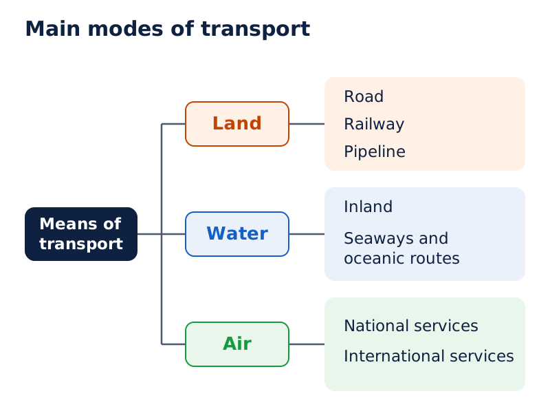
The diagram branches from means of transport into land, water and air. Land divides into road, railway and pipeline; water into inland and seaways and oceanic routes; air into national and international services.
Drawn by One Young India. Reference: NCERT Class 12, unnumbered diagram, page 75
Pathways and unmetalled roads were used in India from ancient times. Unmetalled roads lack a hard, durable surface; metalled roads have such a surface. Economic and technological development brought metalled roads and railways capable of moving large volumes of goods and people.
Ropeways, cableways and pipelines developed to meet the demands of moving particular goods under special circumstances. Ropeways and cableways use cables for transport, while pipelines carry material through connected pipes. Different modes thus respond to different transport requirements.
How does transport connect production and consumption?
- Goods are produced in fields and factories, where production takes place.
- These goods need to move from their places of production to places where they can be purchased.
- Transport carries the produce to markets, connecting production with its place of sale.
- Consumers purchase the goods there, making the transported products available for use.
How did road transport develop, and what do its figures show?
Road transport is relatively suitable for shorter-distance travel. About 85 per cent of passenger traffic and 70 per cent of freight traffic are carried by roads every year. Freight means goods transported, as distinct from passengers.
India's road network measured about 62.16 lakh kilometres in the 2020-21 reporting figures. A kilometre (km) is a unit of distance equal to 1,000 metres, and one lakh means 100,000. Keep the reference year attached to these network figures.
Which developments shaped the network?
Sher Shah Suri built the Shahi or Royal road from the Indus Valley to the Sonar Valley in Bengal to strengthen and consolidate his empire. During British rule it was renamed the Grand Trunk road, connecting Calcutta and Peshawar. Its present extent is Amritsar to Kolkata.
Road transport in the modern sense was very limited before the Second World War. The Nagpur Plan of 1943 was the first serious attempt at development, but lack of coordination between the princely states and British India prevented its implementation.
After Independence, the twenty-year road plan of 1961 sought to improve road conditions. Roads nevertheless continue to concentrate in and around urban centres. Rural and remote areas had the least road connectivity.
What was the composition of the road network in 2020?
| Road category | Length in kilometres, 2020 |
|---|---|
| National Highways, the main roads constructed and maintained by the Central Government | 136,440 |
| State Highways, roads constructed and maintained by state governments | 176,818 |
| Other roads | 5,902,539 |
| Total | 6,215,797 |
The total expresses the size of the network, while traffic shares show how heavily different categories are used. National Highways account for only about 2 per cent of total road length but carry 40 per cent of road traffic.
Note: Road length and traffic share measure different things. The percentage of roads classified as National Highways must not be substituted for the percentage of road traffic they carry.
How do road categories differ in their functions?
For construction and maintenance, roads are classified as National Highways, State Highways, Major District Roads and Rural Roads. Their functions range from connecting states and major cities to linking district centres and rural settlements.
Who maintains the main roads?
| Category | Responsibility or connecting function |
|---|---|
| National Highways (NH) | Constructed and maintained by the Central Government; serve inter-state transport and strategic movement. |
| State Highways (SH) | Constructed and maintained by state governments; connect state capitals, district headquarters and important towns. |
| District Roads | Connect district headquarters with other important centres within the district. |
| Rural Roads | Provide vital links in rural areas; their density varies with the nature of the terrain. |
National Highways also connect major cities, important ports and railway junctions. They serve the movement of defence personnel and material in strategic areas. Their length increased from 19,700 kilometres in 1951 to 136,440 kilometres in 2020.
The National Highways Authority of India (NHAI) became operational in 1995. It is an autonomous body responsible for the development, maintenance and operation of National Highways, and the apex body for improving their quality.
State Highways connect to National Highways. District Roads provide links within districts. Rural Roads form about 80 per cent of India's total road length. Rural road density, meaning the concentration of roads within an area, varies because of differences in terrain.
Case study: How do border roads and Atal Tunnel improve connectivity?
The Border Road Organisation (BRO) was established in May 1960. It improves strategically important roads along the northern and north-eastern boundaries to accelerate economic development and strengthen defence preparedness. It also clears snow in high-altitude areas.
The road joining Chandigarh, Manali and Leh runs at an average altitude of 4,270 metres above mean sea level, the reference level used for measuring altitude. International highways provide links with neighbouring countries to promote harmonious relations.
The BRO built the 9.02-kilometre Atal Tunnel in the Pir Panjal range at an altitude of 3,000 metres. It connects Manali with the Lahaul-Spiti valley throughout the year. Earlier, heavy snowfall cut off the valley for about six months each year.
What are the major highway development projects?
NHAI has undertaken major projects in different phases to improve road connections. These include the Golden Quadrilateral and the North-South and East-West Corridors. A corridor here is a transport route linking places along a major connection.
Which places do the projects connect?
| Project | Connections | Length in kilometres |
|---|---|---|
| Golden Quadrilateral | Delhi, Mumbai, Chennai and Kolkata | 5,846 |
| North-South Corridor | Srinagar to Kanniyakumari, including the Cochin-Salem Spur | 4,076 |
| East-West Corridor | Silchar in Assam to Porbandar in Gujarat | 3,640 |
The Golden Quadrilateral comprises a four-lane or six-lane corridor serving high-density traffic between the four major metropolitan cities. With its construction, the time, distance and cost of movement among these cities will be considerably minimised.
The North-South Corridor aims to connect Srinagar in Jammu and Kashmir with Kanniyakumari in Tamil Nadu. Its length includes the Cochin-Salem spur, or branch connection. The East-West Corridor has been planned to connect Silchar with the port town of Porbandar.
Draw and label
Major highway project endpoints
On an outline map of India, label Delhi, Mumbai, Chennai and Kolkata for the Golden Quadrilateral. Separately mark Srinagar and Kanniyakumari, and Silchar and Porbandar, as the endpoints of the two corridors.
What does Bharatmala Pariyojana envisage?
Bharatmala Pariyojana envisages about 26,000 kilometres of Economic Corridors. Together with the Golden Quadrilateral and the North-South and East-West Corridors, these are expected to carry the majority of freight traffic on roads.
The programme focuses on ring roads, bypasses and elevated corridors to reduce traffic congestion through cities and improve the efficiency of goods movement. Ring roads run around cities, bypasses divert through traffic, and elevated corridors carry traffic above ground level.
Note: An intended connection or expected traffic share is a project objective. Preserve the distinction between what a programme envisages and what has already been achieved.
How have railways developed and connected different regions?
Indian Railways carries both passengers and freight, contributes to economic growth and remains the main means of transport for the masses. The railway began in 1853 with a 34-kilometre line from Bombay to Thane.
Its network length was 67,956 kilometres in 2019-20. The very large network creates pressure on centralised management, so the railway system is divided into 17 zones. A zone is a regional division of the railway management system.
What is railway gauge?
Gauge is the distance between the rails. The three categories are broad gauge, metre gauge and narrow gauge. The following lengths belong to 2019-20; the gauge measurements are distances between rails, not lengths of routes.
| Gauge category | Distance between rails in metres | Line length in kilometres, 2019-20 |
|---|---|---|
| Broad gauge | 1.676 | 63,950 |
| Metre gauge | 1 | 2,402 |
| Narrow gauge | 0.762 or 0.610 | 1,604 |
Narrow gauge is generally confined to hilly areas. An extensive programme converts metre and narrow gauges to broad gauge. Diesel and electric engines have replaced steam engines, increasing speed and haulage capacity, meaning the load that can be carried.
Replacing coal-fired steam engines also improved station environments. Metro rail has transformed urban transport. Its introduction, together with replacing diesel buses with vehicles using compressed natural gas (CNG), is a welcome step towards controlling urban air pollution.
Why does railway density vary?
Colonial railway connections served towns, raw-material-producing areas, plantations, other commercial crop areas, hill stations and cantonment towns, which are military settlements. These links were mostly developed for resource exploitation. After Independence, routes extended to other areas too.
The railway network remains relatively less dense in hill states, north-eastern states, central India and Rajasthan. Railway density describes how concentrated the railway network is within an area; a less dense network is not the same as an absence of railways.
Case study: What makes Konkan Railway significant?
Konkan Railway, constructed in 1998, is a 760-kilometre route from Roha in Maharashtra to Mangalore in Karnataka. Maharashtra, Goa and Karnataka are partners in the undertaking. It provides the western coastal connection that directly links Mumbai and Mangaluru.
The route crosses 146 rivers and streams, nearly 2,000 bridges and 91 tunnels. A tunnel nearly 6.5 kilometres long lies along it. These numerous crossings and tunnels help explain why the route is considered an engineering marvel.
Why are inland waterways important, and which routes are designated?
Water transport carries passengers and cargo, meaning goods carried by a transport service. It is the cheapest means of transport and is most suitable for heavy and bulky materials. It is also fuel-efficient, using fuel economically, and eco-friendly, meaning environmentally friendly.
Inland waterways include rivers, canals, backwaters and creeks used for navigation, or movement by water. Navigable means usable for water transport. India has 14,500 kilometres of navigable waterways, contributing about 1 per cent to the country's transportation.
What limited inland water transport?
Inland waterways were the chief mode of transport before railways. They subsequently faced tough competition from roads and railways. Diversion of river water for irrigation also made rivers non-navigable along large parts of their courses.
The Inland Waterways Authority was established in 1986 for the development, maintenance and regulation of national waterways. The National Waterways Act, 2016 declared 111 inland waterways as National Waterways, including the five declared earlier.
This aimed to create a wide network and promote an economical, environment-friendly mode supplementing rail and road transport. National Waterway (NW) is the designation used in the following route table.
Which five earlier National Waterways should be distinguished?
| National Waterway | Stretch or components | Length in kilometres |
|---|---|---|
| NW 1 | Prayagraj to Haldia on the Ganga | 1,620 |
| NW 2 | Sadiya to Dhubri on the Brahmaputra | 891 |
| NW 3 | Kottapuram to Kollam, including the west coast, Champakara and Udyogmandal canals | 205 |
| NW 4 | Specified stretches of the Godavari and Krishna, with the Kakinada-Puducherry canal stretch | 1,078 |
| NW 5 | Specified stretches of the Brahmani river, the Matai river, delta channels of the Mahanadi and Brahmani rivers, and East Coast canals | 588 |
For development, NW 1 is divided into Haldia-Farakka, 560 kilometres; Farakka-Patna, 460 kilometres; and Patna-Prayagraj, 600 kilometres. The Ganga waterway is navigable by mechanical boats up to Patna and ordinary boats up to Haridwar.
NW 3 includes 168 kilometres of west coast canal, 14 kilometres of Champakara canal and 23 kilometres of Udyogmandal canal. These components belong to one waterway, whose total length is 205 kilometres.
What the figure shows
National Waterway No. 3
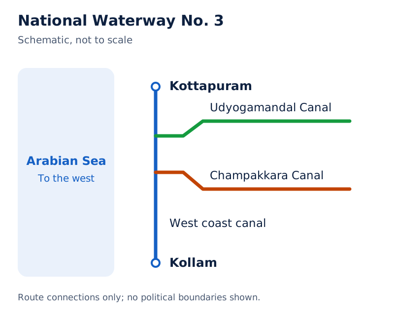
The figure pairs a photograph of long rowing boats with a route map. The map labels Kottapuram, Kollam, Champakkara Canal and Udyogamandal Canal, with the Arabian Sea to the west. It is marked not to scale.
Drawn by One Young India. See Fig. 7.7 in your NCERT textbook
The Kayal, or backwaters, of Kerala provide cheap transport and attract many tourists. The Nehru Trophy Boat Race, also called Vallamkali, is held in these backwaters. Waterways therefore support both transport and tourism.
How do oceanic routes and air transport serve India?
What is the role of oceanic routes?
Oceanic routes are sea routes used for transport. India's coastline is approximately 7,517 kilometres long, including islands. Twelve major ports and 200 minor ports provide the infrastructure supporting these routes.
Approximately 95 per cent of foreign trade by volume and 70 per cent by value moves through ocean routes. Volume concerns the quantity traded; value concerns its monetary worth. These two shares should not be interchanged.
Sea transport also connects the islands with the rest of India. Its role therefore extends beyond international trade to movement between different parts of the country.
Why is air transport important?
Air transport is the fastest means of movement. It reduces the time needed to cover distances and is essential in a vast country where distances are large and terrain and climatic conditions are diverse.
Indian air transport began in 1911 with airmail over the 10-kilometre Prayagraj-Naini route. Its real development occurred after Independence. The Airport Authority of India provides safe, efficient air traffic and aeronautical communication services, meaning communication associated with aviation, in Indian airspace.
How do regional services improve access?
UDAN means Ude Desh ka Aam Nagrik. It is the Regional Connectivity Scheme designed to promote regional aviation and make flying affordable for the common citizen. The Ministry of Civil Aviation conceived the scheme.
Its central idea is to encourage airlines to operate on regional and remote routes through enabling policies and incentives. This explains the connection between affordability and the development of services beyond established air routes.
Pawan Hans operates helicopter services in hilly areas and is widely used by tourists in the north-eastern sector. Pawan Hans Limited mainly provides helicopter services for the petroleum sector and tourism.
How do oil and gas pipelines connect production and use?
Pipelines are the most convenient and efficient mode for transporting liquids and gases over long distances. Solids can also be transported after conversion into slurry, a mixture of solid particles and liquid that can flow through a pipe.
What was Oil India Limited's contribution?
Oil India Limited (OIL) was incorporated as a company in 1959. Under the Ministry of Petroleum and Natural Gas, it undertakes exploration, production and transportation of crude oil and natural gas.
OIL constructed Asia's first cross-country pipeline, covering 1,157 kilometres from the Naharkatiya oilfield in Assam to the Barauni refinery in Bihar. A refinery processes crude oil. The pipeline was extended to Kanpur in 1966.
How did the gas network develop?
GAIL (India) Limited was established in 1984 as a public sector undertaking to transport, process and market natural gas for economic use. Its first cross-country gas pipeline was the 1,700-kilometre Hazira-Vijaipur-Jagdishpur (HVJ) pipeline.
This pipeline linked the Mumbai High and Bassein gas fields with fertiliser, power and industrial complexes in western and northern India. It gave impetus to the development of the Indian gas market by connecting gas sources with consuming centres.
The gas infrastructure expanded over ten times, from 1,700 to 18,500 kilometres of cross-country pipelines. It is expected to soon reach over 34,000 kilometres as a Gas Grid, a connected network linking gas sources and consuming markets, including the North Eastern States.
Note: The figure of over 34,000 kilometres is an expectation for the Gas Grid, not a statement that this length has already been reached. Also distinguish the oil pipeline to Barauni from the HVJ gas pipeline.
How did communication evolve, and what is personal communication?
Early communication methods included beating drums or hollow tree trunks, using smoke or fire signals, and sending fast runners. Horses, camels, dogs, birds and other animals also carried messages. Initially, means of communication were also means of transportation.
The post office, telegraph, printing press, telephone and satellite made communication faster and easier. Scientific and technological development brought major changes in the speed and methods of exchanging messages.
How are communication systems classified?
On the basis of scale and quality, communication is divided into personal communication, involving direct exchanges, and mass communication, which reaches a wider audience. Letters, telephone and electronic mail belong to personal communication; radio and television belong to mass communication.
What the figure shows
Communication systems
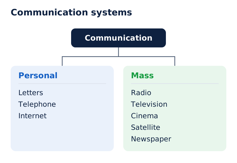
The diagram branches into personal and mass communication. The personal box includes letters, telephone and internet. The mass box includes radio, television, cinema, satellite and newspaper, showing examples within the two categories.
Drawn by One Young India. Reference: NCERT Class 12, unnumbered diagram, page 83
Why is the internet significant?
The internet is the most effective and advanced personal communication system and is widely used in urban areas. It enables direct contact through e-mail, or electronic mail, and provides access to knowledge and information.
It is increasingly used for e-commerce, meaning commercial transactions through electronic networks, and for money transactions. It acts like a huge central store of data containing detailed information on many different items.
Internet and e-mail networks give efficient access to information at a comparatively low cost. Their significance combines direct communication with access to information. The internet is widely used in urban areas.
How did radio and television develop as mass communication systems?
Mass communication distributes information and programmes to a wide audience. Radio broadcasts sound, while television is an audio-visual medium, combining sound and images. Both have developed important roles in information and education in India.
Which events shaped radio broadcasting?
| Year | Development |
|---|---|
| 1923 | The Radio Club of Bombay began radio broadcasting in India. |
| 1930 | The government took control under the Indian Broadcasting System. |
| 1936 | The name changed to All India Radio. |
| 1957 | The name changed to Akashwani. |
All India Radio (AIR) broadcasts programmes for information, education and entertainment. It also broadcasts special news bulletins on particular occasions, including sessions of Parliament and state legislatures.
Radio gained immense popularity after its introduction and changed people's socio-cultural life. Its development involved both a widening influence on everyday life and changes in the organisation and name of the broadcasting service.
How did television extend its reach?
Television services began in the National Capital in 1959 and were initially limited to it. Several other centres became operational after 1972. In 1976, television was separated from AIR and acquired its own identity as Doordarshan (DD).
After INSAT-IA, part of the Indian National Satellite System (INSAT), became operational, Common National Programmes (CNP) began for the entire network. These were programmes shared across the national television network. Television services extended into backward and remote rural areas.
Television emerged as the most effective audio-visual medium for disseminating information and educating the masses. Its growth therefore involved changes in geographical coverage as well as the organisational separation of television from radio.
How do satellites support communication and resource management?
Satellites are means of communication themselves and also regulate the use of other communication media. Their continuous and synoptic view, meaning a broad overview, of large areas makes satellite communication vital for economic and strategic reasons.
Satellite images can support weather forecasting, monitoring of natural calamities and surveillance of border areas. The ability to observe large areas connects communication technology with the management of events and resources across the country.
How do the two satellite systems differ?
Telecommunication means communication over a distance; meteorological observation concerns weather. Remote sensing collects information about an area from a distance. The two satellite systems differ in their configuration and purposes.
| System | Beginning | Main functions |
|---|---|---|
| Indian National Satellite System (INSAT) | Established in 1983 | Multipurpose system for telecommunication, meteorological observation and other data and programmes. |
| Indian Remote Sensing Satellite System (IRS) | Became operational with IRS-IA in March 1988 | Collects and transmits data for different uses, including natural-resource management. |
IRS-IA was launched from Vaikanour in Russia in March 1988.
India developed its own Polar Satellite Launch Vehicle (PSLV). The satellites collect data in several spectral bands, meaning different ranges of electromagnetic radiation, and transmit the data to ground stations for various uses.
How do satellite data become useful?
- Satellites collect information in several spectral bands, obtaining different kinds of observational data.
- They transmit these data to ground stations, making the collected information available on the ground.
- The National Remote Sensing Centre (NRSC) at Hyderabad provides facilities for acquiring and processing data.
- The information supports various uses and is very useful in the management of natural resources.
The systems are grouped according to their configuration and purposes. INSAT's multipurpose communication and observation functions should be distinguished from the data collection and resource-management uses associated with IRS.
Glossary
- Transport — Movement of people and goods between places, linking production, markets and consumption.
- Communication — Exchange of ideas, views and messages between individuals or between different places.
- National Highways — Main roads constructed and maintained by the Central Government for inter-state and strategic transport.
- State Highways — Roads constructed and maintained by state governments, connecting state capitals, district headquarters and important towns.
- Rural Roads — Roads providing vital links in rural areas, with density influenced by the nature of terrain.
- Railway gauge — Distance between the rails, used to distinguish broad, metre and narrow gauge categories.
- Inland waterways — Navigable rivers, canals, backwaters and creeks used to carry passengers and goods.
- Oceanic routes — Sea transport routes supporting international trade and connections between islands and the rest of India.
- Pipelines — Transport systems carrying liquids and gases over long distances, and solids after conversion into slurry.
- Personal communication — Direct exchanges using systems such as letters, telephone, internet and electronic mail.
- Mass communication — Communication reaching a wide audience through media such as radio, television and newspapers.
- INSAT — Indian National Satellite System, established in 1983 for telecommunications, meteorological observation and other data and programmes.
Common errors and misconceptions
- Misconception: National Highways form 40 per cent of India's road length. Correct: They form only about 2 per cent of total road length but carry 40 per cent of road traffic.
- Misconception: Narrow gauge is found only in hilly areas. Correct: It is generally confined to hilly areas; this is not an absolute restriction.
- Misconception: There are just five National Waterways. Correct: The National Waterways Act, 2016 declared 111, including the five declared earlier.
- Misconception: Ocean routes carry 95 per cent of foreign trade by value. Correct: Approximately 95 per cent is the volume share; approximately 70 per cent is the value share.
- Misconception: Pipelines cannot carry solids. Correct: Solids can be transported after conversion into slurry.
- Misconception: India's Gas Grid has already reached over 34,000 kilometres in the figures given. Correct: Expansion to over 34,000 kilometres is an expectation; the stated expanded network is 18,500 kilometres.
- Misconception: INSAT and IRS began in the same year. Correct: INSAT was established in 1983, while IRS became operational with IRS-IA in March 1988.
Exam-style questions with model answers
Q1. National Highways form only about 2 per cent of total road length but carry 40 per cent of road traffic. Using these figures, distinguish their share of the network from their share of traffic. [2 marks]
- National Highways form only about 2 per cent of total road length, so their share of the physical road network is small.
- They carry 40 per cent of road traffic, showing that their traffic role is much greater than their share of road length.
Q2. Use this project information: Golden Quadrilateral, 5,846 kilometres, connects Delhi, Mumbai, Chennai and Kolkata; North-South Corridor, 4,076 kilometres including the Cochin-Salem Spur, aims to connect Srinagar and Kanniyakumari; East-West Corridor, 3,640 kilometres, is planned between Silchar and Porbandar. Identify the three projects through their routes and lengths. [3 marks]
- The Golden Quadrilateral connects Delhi, Mumbai, Chennai and Kolkata. Its length is 5,846 kilometres, linking the four named cities in the project.
- The North-South Corridor aims to connect Srinagar and Kanniyakumari. Its 4,076-kilometre length includes the Cochin-Salem Spur, which must be retained with the figure.
- The East-West Corridor is planned between Silchar and Porbandar. Its proposed connection has a road length of 3,640 kilometres.
Q3. Given that Indian Railways began in 1853 on the 34-kilometre Bombay-Thane route, had a 67,956-kilometre network in 2019-20, was divided into 17 zones because its size pressured centralised management, carries passengers and freight, and replaced steam engines with diesel and electric engines to increase speed and haulage capacity, explain five features of its development and importance. [5 marks]
- Indian Railways began in 1853 with the Bombay-Thane line. This first connection covered a distance of 34 kilometres between the two places.
- By 2019-20, the railway network measured 67,956 kilometres. This figure describes its network length for that reference year.
- The system was divided into 17 zones because its very large size put pressure on a centralised railway management system.
- Railways carry both passengers and freight. Their transport function therefore includes the movement of people as well as goods.
- Diesel and electric engines replaced steam engines. This change increased speed and haulage capacity, allowing trains to carry greater loads.
Q4. Use these facts: India has 14,500 kilometres of navigable inland waterways contributing about 1 per cent of transportation; water transport is cheapest and most suitable for heavy, bulky material; river-water diversion for irrigation made large stretches non-navigable; the National Waterways Act, 2016 declared 111 waterways, including five declared earlier. Explain the scale, advantage, limitation and policy development of inland water transport. [4 marks]
- India has 14,500 kilometres of navigable inland waterways, contributing about 1 per cent to the country's transportation.
- Water transport is the cheapest means and is most suitable for carrying heavy and bulky materials.
- Diversion of river water for irrigation made large stretches non-navigable, limiting their availability for inland water transport.
- The National Waterways Act, 2016 declared 111 inland waterways as National Waterways. This total includes the five declared earlier.
Q5. Pipelines efficiently carry liquids and gases over long distances; solids require conversion into slurry. OIL constructed the 1,157-kilometre Naharkatiya-Barauni oil pipeline, extended to Kanpur in 1966. GAIL constructed the 1,700-kilometre Hazira-Vijaipur-Jagdishpur gas pipeline linking Mumbai High and Bassein gas fields with fertiliser, power and industrial complexes in western and northern India. Explain pipeline suitability and distinguish the two examples. [3 marks]
- Pipelines efficiently transport liquids and gases over long distances. They can also carry solids, but these must first be converted into slurry.
- OIL's 1,157-kilometre pipeline linked Naharkatiya and Barauni. It was subsequently extended to Kanpur in 1966, lengthening that oil transport connection.
- GAIL's 1,700-kilometre Hazira-Vijaipur-Jagdishpur gas pipeline connected Mumbai High and Bassein with fertiliser, power and industrial complexes in western and northern India.
Q6. Ocean routes carry approximately 95 per cent of India's foreign trade by volume and 70 per cent by value. Air transport is the fastest mode and minimises travel time across large distances. State one distinct transport role of each mode using the supplied information. [2 marks]
- Ocean routes support foreign trade, carrying approximately 95 per cent by volume and 70 per cent by value.
- Air transport provides the fastest movement and minimises the time needed to travel over large distances.
Q7. Use these facts: internet and e-mail enable direct personal contact and comparatively low-cost information access; radio broadcasts information, education and entertainment; television began in the National Capital in 1959; television separated from All India Radio (AIR) in 1976 as Doordarshan. Explain two communication functions and two television milestones. [4 marks]
- Internet and e-mail provide direct personal contact and efficient access to information at comparatively low cost, linking communication with knowledge access.
- Radio serves a wider audience through programmes devoted to information, education and entertainment, giving it several mass communication functions.
- Television began in the National Capital in 1959. This identifies both its initial location and the starting year.
- In 1976, television separated from All India Radio and gained a distinct organisational identity under the name Doordarshan.
Q8. Satellites provide continuous, synoptic views of large areas; images support weather forecasts, calamity monitoring and border surveillance. INSAT began in 1983 for telecommunication and meteorological observation. IRS became operational with IRS-IA in March 1988; its satellites collect data in several spectral bands and transmit them to ground stations. NRSC at Hyderabad provides acquisition and processing facilities, and the data are useful for natural-resource management. Explain five contributions of satellite systems using this information. [5 marks]
- Satellites provide continuous, synoptic views of large areas. This means that their observations offer a broad overview rather than a view limited to one small location.
- Satellite images support weather forecasting, monitoring natural calamities and surveillance of border areas. These are three practical applications of their observations.
- INSAT, established in 1983, supports telecommunication and meteorological observation. It therefore serves both communication and weather-related observation functions.
- IRS became operational with IRS-IA in March 1988. Its satellites collect data in several spectral bands and transmit the information to ground stations.
- NRSC at Hyderabad provides facilities for acquiring and processing the data. This information is very useful for managing natural resources.
Key takeaways
- Transport connects production with markets and consumption, while communication exchanges ideas, views and messages between people and places.
- National Highways have only about 2 per cent of total road length but carry 40 per cent of road traffic.
- Railways carry passengers and freight; their network remains relatively less dense in hill states, north-eastern states, central India and Rajasthan.
- Water transport is cheapest and most suitable for heavy and bulky goods; inland waterways supplement road and rail transport.
- Ocean routes carry approximately 95 per cent of foreign trade by volume and 70 per cent by value.
- Pipelines carry liquids and gases over long distances, while solids require conversion into slurry before pipeline transport.
- The internet enables direct communication and information access; radio and television provide important means of mass communication.
- INSAT supports multipurpose communication and observation, while IRS data and ground processing assist natural-resource management.
Test yourself
What are the three main modes of transport?
The three main modes are land transport, water transport and air transport.
Which four cities does the Golden Quadrilateral connect?
It connects the four major cities of Delhi, Mumbai, Chennai and Kolkata.
What does railway gauge measure?
Railway gauge measures the distance between the rails, rather than the total length of a railway route.
Which places are connected by the 760-kilometre Konkan Railway route?
The route connects Roha in Maharashtra with Mangalore in Karnataka.
What does UDAN aim to achieve?
UDAN promotes regional air connectivity by making flying affordable and encouraging airlines to serve regional and remote routes.
Why must the 34,000-kilometre Gas Grid figure be qualified?
The network is expected to soon reach over 34,000 kilometres; that is a projected expansion, not an achieved length in the stated figures.
When did television acquire its separate identity as Doordarshan?
Television separated from All India Radio in 1976 and acquired its own identity as Doordarshan.
What does the National Remote Sensing Centre at Hyderabad provide?
It provides facilities for acquiring and processing satellite data, which are very useful in natural-resource management.
Write about it
Turn a question from this chapter into a paper.
The Writing Studio has a structure guide, a rubric and citation tools for 15 formats, from essays to research papers. Drafting is free with an account. Learnacy Essential adds feedback from an AI writing coach and submission to The OYI Review.
Learnacy Essential is ₹1,499 for the year. Publication depends on review and is not guaranteed.