
Water Resources | CBSE Class 12 Geography Notes
On this page
Watch & explore
Start with a few high-quality watches, then dive into the notes below.
Water availability in India, rivers and underground water, coastal water bodies, agricultural water needs, declining supplies, pollution, water conservation, village experiences, rainwater collection and national water-management programmes.
Why can water be scarce despite its abundance on Earth?
Water is a cyclic resource: it circulates and can be replenished through the water cycle. Approximately 71 per cent of the earth’s surface is covered with water, but freshwater, water with little dissolved salt, constitutes only about 3 per cent of total water.
A very small proportion of freshwater is effectively available for human use. Its availability varies over space and time. Therefore, abundant water on the globe does not mean that sufficient usable water is available in every place and season.
How do demand and supply create pressure?
Water scarcity means a shortage of water relative to requirements. It is possibly to pose the greatest challenge as demand increases while supplies shrink through over-utilisation and pollution. Increasing population reduces per capita availability, meaning the amount available per person.
Industrial, agricultural and household wastes further limit usable supplies. Water that is present in a river or underground cannot be treated as fully available for human use when its quality has deteriorated. Quantity and quality therefore need attention together.
Sharing and control of scarce water are becoming contested issues among communities, regions and states. Assessment, efficient use and conservation of water are necessary to ensure development. Conservation means protecting supplies and using water carefully so that waste and depletion are reduced.
Note: Water’s cyclic character does not guarantee adequate local supplies. Increased demand, over-utilisation, pollution and uneven availability can create scarcity even though water continues to circulate.
How much water is available in India, and how is surface water distributed?
India accounts for about 2.45 per cent of the world’s surface area, 4 per cent of its water resources and more than 17 per cent of its population. These shares show the pressure of a large population on a relatively small share of water resources.
Precipitation, water falling from the atmosphere, provides about 4,000 cubic kilometres annually. A cubic kilometre is a unit of volume. Surface water is water in bodies such as rivers, lakes, ponds and tanks; groundwater is water below the ground.
Replenishable groundwater is the groundwater supply that can be renewed. Surface water and replenishable groundwater together provide 1,869 cubic kilometres. Only 60 per cent can be put to beneficial uses, giving a total utilisable water resource, or water available for beneficial use, of 1,122 cubic kilometres.
| Water-resource measure | Volume in cubic kilometres |
|---|---|
| Annual precipitation | About 4,000 |
| Surface water and replenishable groundwater availability | 1,869 |
| Total utilisable water resource | 1,122 |
| Utilisable surface water | About 690 |
| Total replenishable groundwater | About 432 |
What determines river-water availability?
The four major surface-water sources are rivers, lakes, ponds and tanks. India has about 10,360 rivers and their tributaries, rivers joining larger rivers, longer than 1.6 kilometres each. Topographical constraints, relating to land relief, and hydrological constraints, relating to water conditions, restrict utilisation.
River flow depends on the size of its catchment area or river basin, the area supplying water to the river, and rainfall within it. Precipitation varies greatly across India and is mainly concentrated in the monsoon season. The Ganga, Brahmaputra and Indus have huge catchment areas.
The Ganga, Brahmaputra and Barak catchments receive relatively high precipitation. Although they account for only about one-third of the country’s area, they have 60 per cent of its total surface-water resources. Much annual flow in the Godavari, Krishna and Kaveri has been harnessed; this is yet to be done in the Brahmaputra and Ganga basins.
What the figure shows
India’s river basins
The map outlines and labels river basins, including the Indus, Ganga, Brahmaputra, Barak, Mahanadi, Godavari, Krishna and Kaveri. Its legend distinguishes west-flowing and east-flowing drainage. Basin boundaries show the areas associated with rivers. Drainage means the movement of water through a river system.
See Fig. 4.1 in your NCERT textbook
How do groundwater use and coastal water resources vary?
India has about 432 cubic kilometres of replenishable groundwater. The level of groundwater utilisation is relatively high in river basins of the north-western region and parts of south India. The proportion of available groundwater used differs substantially among states.
Which states use their groundwater intensively?
| Level of groundwater utilisation | State examples |
|---|---|
| Very high | Punjab, Haryana, Rajasthan and Tamil Nadu |
| Moderate rate | Gujarat, Uttar Pradesh, Bihar, Tripura and Maharashtra |
| Small proportion of groundwater potential | Chhattisgarh, Odisha and Kerala |
Groundwater potential refers here to the available groundwater resource that can be used. A state’s utilisation level describes how intensively it uses that potential. High utilisation is therefore different from simply possessing a large groundwater resource.
Over-use can lower the groundwater table, the upper level of groundwater beneath the surface. A continuing imbalance between water demand and supply can harm development and cause social upheaval and disruptions. Managing demand is consequently part of managing water resources.
How are lagoons and backwaters useful?
Lagoons and backwaters are coastal water bodies associated with the sea. India has a vast coastline that is very indented in some states. A number of lagoons and lakes have formed along it, providing substantial surface-water resources.
Kerala, Odisha and West Bengal have vast water resources in these lagoons and lakes. Their water is generally brackish, meaning somewhat salty. Nevertheless, it is used for fishing and for irrigating certain varieties of paddy crops, coconut and other crops.
The qualification “certain varieties” matters: coastal water cannot be treated as equally suitable for every crop. These resources add to the range of water bodies available for use, alongside rivers, inland lakes, ponds, tanks and groundwater.
Why does agriculture require so much water?
Irrigation is the supply of water to agricultural land. India’s water demand is dominated by irrigation needs. Its traditionally agrarian economy, an economy strongly dependent on agriculture, explains the high priority given to irrigation development in the Five Year Plans.
Multipurpose river-valley projects taken up include Bhakra-Nangal, Hirakud, Damodar Valley, Nagarjuna Sagar and the Indira Gandhi Canal Project. Agriculture accounts for most surface-water and groundwater utilisation, with much larger shares than industry or households.
| Use | Share of surface-water utilisation | Share of groundwater utilisation |
|---|---|---|
| Agriculture | 89 per cent | 92 per cent |
| Industry | 2 per cent | 5 per cent |
The domestic sector, meaning household use, accounts for 9 per cent of surface-water utilisation, a higher share than its groundwater share. With development, industrial and domestic shares are likely to increase. The proportions used by different sectors can therefore change with economic development.
Why is rainfall insufficient for dependable farming?
- Spatial variation: rainfall differs between places. Large tracts of north-western India and the Deccan plateau have deficient rainfall and are drought prone.
- Seasonal variation: winter and summer are more or less dry in most parts of the country, making assured irrigation important during dry seasons.
- Monsoon interruptions: even West Bengal and Bihar, with ample rainfall, suffer agricultural dry spells when the monsoon breaks or fails.
- Crop requirements: rice, sugarcane and jute have very high water requirements that can be met only through irrigation.
Irrigation makes multiple cropping, growing more than one crop on the same land during a year, possible. Irrigated land has higher agricultural productivity than unirrigated land. High-yielding varieties, crop varieties capable of high output, need regular moisture supplied by developed irrigation systems.
What does the Case study of Punjab and Haryana show about irrigation?
Punjab, Haryana and western Uttar Pradesh illustrate the connection between assured irrigation and agricultural development. The Green Revolution strategy, agricultural development associated here with high-yielding crops and regular irrigation, has largely been successful in these areas.
More than 85 per cent of their net sown area, land sown at least once during a year, with each plot counted once, is irrigated. Wheat and rice are grown mainly with irrigation. This pattern creates a close relationship between agricultural production and dependable water supplies.
How important are wells and tubewells?
Net irrigated area is land irrigated at least once during a year, with each plot counted once. Wells and tubewells, structures used to withdraw groundwater, irrigate large proportions of this area in Punjab and Haryana.
| State | Share of total net irrigated area irrigated through wells and tubewells |
|---|---|
| Punjab | 76.1 per cent |
| Haryana | 51.3 per cent |
These figures indicate utilisation of a large proportion of groundwater potential. Such use has resulted in groundwater depletion, a reduction in groundwater supplies. Over-use has lowered the groundwater table. Intensive irrigation is also increasing soil salinity, meaning the accumulation of salts in soil.
The figures have different bases: more than 85 per cent refers to irrigation within net sown area; 76.1 and 51.3 per cent refer to wells and tubewells within total net irrigated area. They should not be treated as percentages of the same total.
Over-withdrawal has also increased fluoride concentration in groundwater in some states, like Rajasthan and Maharashtra, and arsenic concentration in parts of West Bengal and Bihar. Fluoride and arsenic are substances whose increased concentrations contribute to groundwater-quality problems.
How does water quality deteriorate?
Definition: Water quality refers to the purity of water, or water without unwanted foreign substances. Pollution occurs when unwanted materials enter water and deteriorate its quality, limiting its suitability for human use.
Foreign matter includes micro-organisms, organisms too small to see individually without magnification, chemicals, industrial wastes and other wastes. These materials can render water unfit for human use. Toxic substances, substances harmful to living things, also affect aquatic systems, the living systems in water.
How do pollutants enter and move through water?
- Agricultural drains carry fertilisers, substances supplying plant nutrients, and insecticides, substances used to control insects; domestic drains carry solid and liquid waste; industrial drains carry effluents, discharged wastewater and wastes.
- These drains join rivers, introducing unwanted materials into water already used for irrigation, drinking, household needs and industry.
- Toxic substances entering lakes, streams, rivers, oceans and other water bodies dissolve or remain suspended, meaning carried as particles within the water.
- Water quality deteriorates and aquatic systems are affected. Sometimes pollutants also seep down and contaminate groundwater.
Major rivers generally retain better water quality in their less densely populated upper stretches in hilly areas. In the plains, river water is used intensively. Pollutant concentrations remain especially high during summer when river flow is low.
What the figure shows
The Ganga, its tributaries and towns
The map shows the Ganga river system and marks cities, including Delhi, Prayagraj and Varanasi. Callouts label “Good Quality Water here” in the upper area and “Poor Quality Water here” at locations farther downstream. The legend also identifies irrigated land.
See Fig. 4.2 in your NCERT textbook
Population growth reduces water availability per person, while pollution reduces the usable portion of the resource. Water problems therefore involve both declining availability and deteriorating quality. Protecting quality is an essential part of maintaining supply.
How can pollution prevention and water reuse conserve supplies?
The Central Pollution Control Board (CPCB), working with State Pollution Control Boards, monitors water quality. Organic contamination, pollution by organic matter, and bacterial contamination, pollution involving bacteria, continue to be the main sources of river pollution.
The Yamuna is the most polluted river in the country between Delhi and Etawah. Other severely polluted rivers include the Sabarmati at Ahmedabad, Gomti at Lucknow, Kali, entire stretches of the Adyar and Cooum, Vaigai at Madurai, Musi of Hyderabad, and Ganga at Kanpur and Varanasi.
Groundwater pollution occurs through high concentrations of heavy or toxic metals, fluoride and nitrates in different parts of the country. Nitrates are chemical substances that can contaminate groundwater at high concentrations. Both surface and underground supplies require protection.
Why do laws need public action?
The Water (Prevention and Control of Pollution) Act 1974 and Environment Protection Act 1986 have not been implemented effectively. In 1997, 251 polluting industries were located along rivers and lakes. The Water Cess Act, 1977, meant to reduce pollution, also made marginal impacts.
Public awareness of water’s importance and pollution’s impacts is strongly needed. Awareness and action can be very effective in reducing pollutants from agriculture, households and industries. Conservation requires preventing pollution as well as developing water-saving technologies and methods.
Which uses can accept reused water?
Recycling and reuse mean recovering water or using it again for a suitable purpose. Reclaimed wastewater, wastewater recovered for further use, would be an attractive option for industrial cooling and firefighting, reducing water costs and conserving better-quality water.
Water after bathing or washing utensils can be used for gardening in urban areas. Water used to wash vehicles can also serve this purpose. This conserves better-quality water for drinking. Recycling is practised on a limited scale, but there is enormous scope for replenishing water through recycling.
What is watershed management, and how does participation support it?
A watershed here means a drainage area managed as a unit, bringing land and water resources together. Watershed management basically means efficient management and conservation of surface water and groundwater. It includes preventing runoff, water flowing over the ground, and storing water and recharging groundwater.
Recharge means replenishing groundwater by allowing water to enter the ground. Percolation tanks store water for infiltration, its entry into the soil; recharge wells direct water underground. These are among the methods used to support groundwater supplies.
Why is the approach broader than water storage?
In its broad sense, watershed management includes conserving, regenerating and judiciously using all natural and human resources within a watershed. Natural resources include land, water, plants and animals. Its aim is a balance between natural resources and society.
Success largely depends upon community participation. Central and State Governments have initiated many programmes, and some are implemented by non-governmental organisations, organisations operating outside government. Local participation is important to both physical work and continuing resource management.
Haryali is a Central Government-sponsored watershed project intended to enable rural people to conserve water for drinking, irrigation, fisheries and afforestation, the establishment of tree cover. Gram Panchayats, village-level local governing bodies, execute it with people’s participation.
Neeru-Meeru, meaning “Water and You”, in Andhra Pradesh and Arvary Pani Sansad in Alwar, Rajasthan, have used people’s participation to construct water-harvesting structures. These include percolation tanks, dug-out ponds called Johad, and check dams, small barriers that hold back flowing water.
Watershed development has rejuvenated the environment and economy in some areas. However, there are only a few success stories. In the majority of cases the programme remains in its nascent stage, an early stage of development. Greater awareness of its benefits is needed.
How did the Case study of Ralegan Siddhi link water management with village change?
Ralegan Siddhi, in Ahmadnagar district, Maharashtra, became an example of watershed development. In 1975, the village faced poverty and illicit liquor trading. A retired army person settled there and began organising watershed-development work and wider social changes.
What changed the village’s water supply?
The village’s percolation tank could not hold water because its embankment, the raised wall retaining water, leaked. Villagers voluntarily repaired it. The seven wells below the tank filled with water in summer for the first time in the people’s living memory.
Voluntary labour reduced dependence on government financial aid and shared the project’s costs across the community. People working outside the village contributed a month’s salary every year. The improvement in the wells helped establish trust in the effort.
How did resource rules and social organisation reinforce the work?
- Open grazing was completely banned, with greater emphasis on stall-feeding, feeding animals in an enclosure instead of allowing open grazing.
- Cultivation of water-intensive sugarcane was banned. Pulses, oilseeds and certain cash crops, crops grown for sale, with low water requirements were encouraged.
- The youth group Tarun Mandal worked against dowry, caste discrimination and untouchability. Liquor-distilling units were removed and prohibition imposed.
- Local-body elections came to be based on consensus, or shared agreement. Nyay Panchayats, informal courts, were also established.
A school building costing 22 lakh rupees was constructed using village resources without donations. Villagers helped each other with agricultural operations, and landless labourers gained employment. These activities connected self-reliance, shared labour and village development.
Photographs: Ralegan Siddhi before mitigation approach and Ralegan Siddhi after mitigation approach (NCERT Class 12, unnumbered photographs, page 48). The first photograph shows a largely bare, uneven landscape. The second shows cultivated plots and more visible tree cover. These are photographs, rather than schematic drawings.
Water became adequate and agriculture flourished, though fertiliser and pesticide use was very high. Pesticides are substances used to control pests. Continued prosperity also raised the question of the next generation’s ability to carry on the work after the movement’s leader.
How does rainwater harvesting improve water availability?
Rainwater harvesting means capturing and storing rainwater for different uses. It can also recharge groundwater aquifers, underground layers that hold and transmit water. The method is low cost and eco-friendly, guiding rainwater towards borewells, pits and wells.
What forms can harvesting take?
Traditional rural methods use lakes, ponds and irrigation tanks for surface storage. In Rajasthan, a Kund or Tanka is a covered underground tank constructed near or within a house or village to store harvested rainwater.
Rooftops and open spaces offer wide scope for harvesting. Tamil Nadu has made water-harvesting structures in houses compulsory: no building can be constructed without such structures. Urban areas can especially benefit because demand has already outstripped supply in most cities and towns.
What the figure shows
Various methods of rainwater harvesting
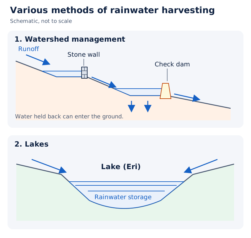
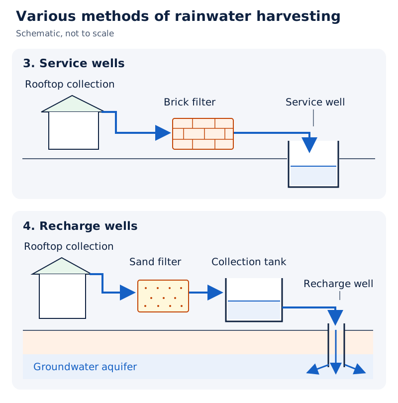
Four panels show harvesting through watershed management, lakes labelled “Eri”, service wells and recharge wells. The watershed panel labels a stone wall and check dam. The service-well panel labels rooftop collection and a brick filter; the recharge-well panel labels a sand filter, collection tank and recharge well.
Drawn by One Young India. See Fig. 4.3 in your NCERT textbook
What benefits follow from collection and recharge?
- Greater availability: stored rainfall adds to water supplies and helps bridge the gap between demand and supply.
- Groundwater support: recharge checks the declining groundwater table and improves quality through dilution, reducing the concentration of contaminants such as fluoride and nitrates.
- Protection of land: harvesting prevents soil erosion, the removal of soil, and flooding.
- Coastal protection: it arrests saltwater intrusion, the entry of salty water, in coastal areas if used to recharge aquifers.
- Lower dependence and energy use: harvesting reduces reliance on groundwater for domestic needs and can save pumping energy as recharge raises the groundwater table.
The condition attached to the coastal benefit is essential: arresting saltwater intrusion is linked to using harvested rainwater to recharge aquifers. Collection for immediate use and collection for groundwater recharge serve related but distinct purposes.
What principles guide national water conservation and management?
Declining freshwater availability and rising demand require effective conservation and management. Sustainable development here requires conserving water while supporting continuing development. Policies, laws, pollution prevention and water-saving methods are all parts of this task. Conjunctive use, coordinated use of surface water and groundwater, also supports long-term water supply.
Desalinisation, the removal of dissolved salts from water, has a high cost, so water availability from seas and oceans is considered negligible. Desalinisation of coastal water and brackish water in arid and semi-arid areas can nevertheless be important remedies.
Arid and semi-arid areas are dry and comparatively dry regions. Inter-linking of rivers means linking river systems to transfer water from water-surplus areas to water-deficit areas. Such transfers can also be important remedies. Water pricing is the most important issue for individual users, households and communities.
What does the National Water Policy 2012 recommend?
The National Water Policy 2012 aims to assess existing conditions and propose an action framework with a unified national perspective. Its recommendations address conservation, development and improved management of India’s water resources.
- Develop a national water framework law and comprehensive legislation for optimum development of inter-State rivers and river valleys.
- After priority needs are met, treat water as an economic good, a resource whose value encourages conservation and efficient use. These needs include safe drinking water, sanitation, food security, poor agricultural livelihoods and minimum ecosystem requirements. An ecosystem comprises living organisms and their interactions with their environment.
- Use adaptation strategies for climate change when designing and managing water-resource structures, and review the criteria for their acceptability.
- Develop benchmarks for different water uses, described as water footprints, and water auditing, assessment of water use, to improve efficiency.
- Remove large disparities in provisions for urban and rural water supply.
- Manage water-resource projects and services with community participation.
The policy’s economic approach follows priority allocations. It does not remove the prior claims of drinking water, sanitation, food security, vulnerable agricultural livelihoods or the minimum water needs of ecosystems.
How do national programmes address irrigation and community water security?
What are the objectives of Pradhan Mantri Krishi Sinchayee Yojana?
Pradhan Mantri Krishi Sinchayee Yojana (PMKSY) was launched by the Central Government during 2015-16. Its overarching vision is access to some means of protective irrigation for all agricultural farms, supporting rural prosperity. Protective irrigation supplies water to protect crops against inadequate rainfall.
- Improve physical access to farm water and expand cultivable area under assured irrigation, expressed as Har khet ko pani, water for every field.
- Integrate water sources, distribution and efficient use through appropriate technologies and practices.
- Improve on-farm efficiency, reduce wastage and promote irrigation and water-saving technologies under the idea of Per drop more crop, more crop output from each drop.
- Introduce sustainable water-conservation practices and integrate development of rain-fed areas, areas dependent on rainfall, with soil and water conservation, groundwater regeneration and livelihood options.
How does Atal Bhujal Yojana encourage conservation?
Atal Bhujal Yojana (Atal Jal) promotes community behavioural change from consumption towards conservation and smart water management. Its 2022-23 programme coverage includes 8,220 water-stressed Gram Panchayats in 229 administrative blocks or talukas across 80 districts in seven states.
Water-stressed areas face pressure on available supplies; blocks and talukas are administrative subdivisions. The seven states are Gujarat, Haryana, Karnataka, Madhya Pradesh, Maharashtra, Rajasthan and Uttar Pradesh. They account for about 37 per cent of India’s water-stressed blocks.
What activities were proposed under Jal Kranti Abhiyan?
Jal Kranti Abhiyan, launched in 2015-16, aims to ensure water security through per capita availability. Water security means ensuring water availability for needs. The campaign involves local bodies, non-governmental organisations and citizens, connecting water security with livelihood and food security.
- Select one water-stressed village in each of 672 districts to create a Jal Gram, a village selected for the campaign’s water-security work.
- Identify model command areas of about 1,000 hectares in different parts of India. A command area is land served by an irrigation system; a hectare is a unit of land area.
- Reduce pollution through water conservation, artificial recharge, reducing groundwater pollution and constructing arsenic-free wells in selected areas.
- Create mass awareness through social media, radio, television, print media, posters and school essay-writing competitions.
The command-area examples cover Uttar Pradesh and Haryana in the north; Karnataka, Telangana and Tamil Nadu in the south; Rajasthan and Gujarat in the west; Odisha in the east; and Meghalaya in the north-east.
Glossary
- Cyclic resource — A resource that circulates and can be replenished through a continuing natural cycle.
- Per capita availability — The amount of a resource available per person in a population.
- Surface water — Water present in surface bodies such as rivers, lakes, ponds and tanks.
- Replenishable groundwater — The groundwater resource that can be renewed rather than representing an unchanging underground stock.
- Catchment area — The area supplying water to a river, also described as its river basin.
- Brackish water — Water that is somewhat salty, as generally found in the coastal lagoons and lakes discussed here.
- Irrigation — The supply of water to agricultural land to support the growing of crops.
- Groundwater table — The upper level of groundwater below the surface of the ground.
- Water quality — The purity of water, understood as water without unwanted foreign substances.
- Effluents — Discharged wastewater and wastes that can carry pollutants into receiving water bodies.
- Watershed management — Efficient conservation and management of surface water and groundwater, extending broadly to natural and human resources.
- Groundwater recharge — Replenishment of groundwater by allowing water to enter and move into the ground.
- Rainwater harvesting — Capturing and storing rainwater for different uses, including the recharge of groundwater aquifers.
- Aquifer — An underground layer that can hold water and transmit it through the ground.
- Kund or Tanka — A covered underground tank used in Rajasthan to store harvested rainwater near or within houses or villages.
Common errors and misconceptions
- Misconception: Water’s cyclic nature prevents scarcity. Correct: Usable freshwater is limited and unevenly available; growing demand, over-utilisation and pollution create pressure on supplies.
- Misconception: India can use all the water received through annual precipitation. Correct: About 4,000 cubic kilometres arrives through precipitation, while the total utilisable resource is 1,122 cubic kilometres.
- Misconception: Irrigation is unnecessary in areas of ample rainfall. Correct: Monsoon breaks or failure can create harmful dry spells even in West Bengal and Bihar.
- Misconception: Punjab’s 76.1 per cent measures the irrigated share of net sown area. Correct: It measures the share of total net irrigated area irrigated through wells and tubewells.
- Misconception: Watershed management consists only of building tanks. Correct: Its broad scope covers conservation, regeneration and judicious use of natural and human resources, with community participation.
- Misconception: Ralegan Siddhi demonstrates success without any continuing concerns. Correct: Agriculture flourished, though fertiliser and pesticide use was very high, and continuity across generations remained a concern.
- Misconception: Any collection of rainwater automatically arrests coastal saltwater intrusion. Correct: This benefit is attached to using harvested water to recharge aquifers.
- Misconception: Treating water as an economic good overrides basic needs. Correct: The policy places drinking water, sanitation, food security, poor agricultural livelihoods and minimum ecosystem needs first.
Exam-style questions with model answers
Q1. Agriculture uses 89 per cent of surface-water utilisation and 92 per cent of groundwater utilisation; industry uses 2 per cent and 5 per cent respectively. Identify the larger user and calculate its lead in each category. A percentage-point difference is the difference between two percentages. [2 marks]
- Agriculture is the larger surface-water user: its lead over industry is 89 minus 2, or 87 percentage points.
- Agriculture is also the larger groundwater user: its lead is 92 minus 5, again 87 percentage points.
Q2. Given that annual precipitation supplies about 4,000 cubic kilometres and total utilisable water is 1,122 cubic kilometres, state what each figure measures and explain why they should not be treated as equal. Topographical, hydrological and other constraints limit utilisation. [2 marks]
- About 4,000 cubic kilometres measures annual precipitation, whereas 1,122 cubic kilometres measures the water resource available for beneficial use.
- The figures differ because topographical, hydrological and other constraints restrict utilisation; receiving precipitation does not make all that water utilisable.
Q3. Punjab and Haryana irrigate 76.1 per cent and 51.3 per cent of total net irrigated area through wells and tubewells. More than 85 per cent of net sown area in Punjab, Haryana and western Uttar Pradesh is irrigated. Over-use has depleted groundwater and lowered its table. Explain these figures and their implications in four points. [4 marks]
- Punjab’s 76.1 per cent measures the share of its total net irrigated area served by wells and tubewells, showing substantial dependence on groundwater.
- Haryana’s corresponding share is 51.3 per cent, so wells and tubewells also serve a large part of its net irrigated area.
- The more-than-85-per-cent figure uses a different base: net sown area. It describes overall irrigation coverage across the three named agricultural areas.
- Over-use has depleted groundwater and lowered its table, showing that extensive irrigation must be accompanied by careful management of groundwater supplies.
Q4. Use these facts to explain five reasons for irrigation: north-western India and the Deccan plateau have deficient rainfall; winter and summer are more or less dry in most parts; monsoon breaks affect even West Bengal and Bihar; rice, sugarcane and jute require much water; irrigation permits multiple cropping and regular moisture for high-yielding varieties. [5 marks]
- Low rainfall in large tracts of north-western India and the Deccan plateau creates a need for irrigation to support agriculture in drought-prone areas.
- Winter and summer are more or less dry in most parts of the country, making assured irrigation important for farming in these seasons.
- Even areas with ample rainfall, such as West Bengal and Bihar, need irrigation because monsoon breaks or failure create dry spells harmful to agriculture.
- Rice, sugarcane and jute have very high water requirements, so irrigation is necessary to meet the water needs of these crops.
- Irrigation supports multiple cropping and provides regular moisture for high-yielding varieties, connecting dependable water supply with agricultural production.
Q5. At Ralegan Siddhi, villagers repaired a leaking percolation-tank embankment, after which seven downstream wells held summer water. Voluntary labour reduced dependence on government aid. Open grazing and sugarcane cultivation were banned; lower-water crops were encouraged. Agriculture flourished, though fertiliser and pesticide use was very high. Explain five lessons from these facts. [5 marks]
- Repairing the leaking embankment improved the village’s water situation: the seven wells below the percolation tank held water during summer after the repair.
- Voluntary labour shared the work of development among villagers and reduced dependence on government financial aid, demonstrating the role of community participation.
- Banning open grazing made control over the use of village natural resources part of the wider effort to improve local conditions.
- Banning sugarcane and encouraging crops with lower water requirements linked agricultural choices to water conservation rather than focusing solely on increasing supplies.
- Flourishing agriculture did not remove every concern: very high fertiliser and pesticide use remained a qualification to the village’s agricultural prosperity.
Q6. Rainwater harvesting captures and stores rain, recharges groundwater, dilutes contaminants such as fluoride and nitrates, prevents soil erosion and flooding, and arrests coastal saltwater intrusion if used to recharge aquifers. It reduces domestic dependence on groundwater and can save pumping energy when recharge raises the groundwater table. Explain five benefits, retaining the conditions. [5 marks]
- Capturing and storing rainfall increases water availability for different uses, helping to reduce the gap between the water people need and available supplies.
- Recharge replenishes groundwater and checks its declining table, while dilution improves groundwater quality by reducing concentrations of contaminants such as fluoride and nitrates.
- Rainwater harvesting prevents soil erosion and flooding, connecting the conservation of water with protection of the land on which rainfall is received.
- It arrests saltwater intrusion in coastal areas if harvested rainwater is used to recharge aquifers; the stated benefit depends on that use.
- It reduces household dependence on groundwater and can save pumping energy because groundwater recharge leads to a rise in the groundwater table.
Q7. Agricultural, domestic and industrial drains carry pollutants into rivers. Pollutant concentrations remain especially high in summer when flow is low. Sometimes pollutants seep down into groundwater. Explain three water-quality problems using these facts. [3 marks]
- Drains from farms, homes and industries introduce pollutants into river water, deteriorating its quality and reducing the portion suitable for use.
- During summer, river flow is low and pollutant concentrations remain especially high, making seasonal conditions an important part of the pollution problem.
- Sometimes pollutants seep down into groundwater, so contamination is not confined to visible surface-water bodies and can also affect underground supplies.
Q8. The National Water Policy 2012 gives priority to safe drinking water, sanitation, food security, poor agricultural livelihoods and minimum ecosystem needs before treating water as an economic good. It recommends water-use benchmarks and auditing, and community participation in projects and services. Explain these three principles. [3 marks]
- Priority needs must be met before water is treated as an economic good: drinking water, sanitation, food security, poor agricultural livelihoods and minimum ecosystem requirements come first.
- Water-use benchmarks and auditing are intended to ensure efficient use, making assessment of how water is used part of its management.
- Community participation should guide the management of water-resource projects and services, giving people a role in the management of their water resources.
Key takeaways
- Water is cyclic, but only a very small proportion of freshwater is effectively available for human use.
- India’s total utilisable water resource is 1,122 cubic kilometres; rainfall, basin size and utilisation constraints shape availability.
- Agriculture accounts for 89 per cent of surface-water utilisation and 92 per cent of groundwater utilisation.
- Irrigation supports farming through dry seasons and monsoon interruptions, but over-use has depleted groundwater in intensively irrigated areas.
- Pollution limits usable supplies; prevention, public awareness, recycling and suitable reuse belong within water conservation.
- Watershed management includes natural and human resources, and its success largely depends upon community participation.
- Ralegan Siddhi combined tank repair, voluntary labour, resource-use restrictions and cropping changes, while retaining concerns about agricultural chemicals.
- Rainwater harvesting stores water and supports recharge; coastal saltwater protection depends on using harvested water to recharge aquifers.
- National water policy combines priority needs, efficient use, climate adaptation, reduced rural-urban disparities and community participation.
Test yourself
Which four major sources provide surface water?
The four major surface-water sources are rivers, lakes, ponds and tanks.
Which three river catchments have 60 per cent of India’s surface-water resources?
The Ganga, Brahmaputra and Barak catchments have 60 per cent, while covering only about one-third of the country’s total area.
Which states have very high groundwater utilisation?
Punjab, Haryana, Rajasthan and Tamil Nadu have very high groundwater utilisation.
Why can West Bengal and Bihar need irrigation despite ample rainfall?
Breaks in the monsoon or its failure create dry spells that are detrimental to agriculture.
How can household water be reused for another purpose?
Water after bathing, washing utensils or washing vehicles can be used for gardening, conserving better-quality water for drinking.
Who executes Haryali, and what does it conserve water for?
Gram Panchayats execute Haryali with people’s participation, conserving water for drinking, irrigation, fisheries and afforestation.
What is a Kund or Tanka?
It is a covered underground tank in Rajasthan used to store harvested rainwater near or within a house or village.
What behavioural change does Atal Jal seek?
It seeks to shift communities from an attitude of consumption towards conservation and smart water management.
Write about it
Turn a question from this chapter into a paper.
The Writing Studio has a structure guide, a rubric and citation tools for 15 formats, from essays to research papers. Drafting is free with an account. Learnacy Essential adds feedback from an AI writing coach and submission to The OYI Review.
Publication depends on review and is not guaranteed.