
Transport and Communication (World) | CBSE Class 12 Geography Notes
On this page
This note covers transport networks, the choice of transport modes, roads and highways, railways, major sea routes, shipping canals, inland waterways, air transport, pipelines, satellite communication and cyberspace.
What is transport, and how do different modes complement one another?
Transport is a service or facility that carries people and goods from one place to another using humans, animals and vehicles. Communication connects people through the exchange of information. Transport, communication and trade link producing centres with consuming centres.
Natural resources, economic activities and markets are rarely found together. Each region produces the items for which it is best suited. The exchange of these commodities, or goods, depends on transport and communication. Efficient services also support high living standards and quality of life.
Definition: A transport network is a pattern formed by several places, called nodes, joined by a series of routes, called links.
How is transport organised?
Transport is an organised service industry. It includes routes, vehicles, maintenance organisations and arrangements for loading, unloading and delivery. Assured and speedy transportation, together with efficient communication, promotes cooperation and unity among scattered peoples. Nations also develop transport for defence.
The principal modes are land, water, air and pipelines. They serve movement between regions and within regions. Except for pipelines, each carries both passengers and freight, meaning goods transported as cargo. Suitability depends on the goods or services, transport costs and available modes.
| Mode | Particular suitability |
|---|---|
| Roads | Cheaper and faster over short distances, with door-to-door service from the starting point to the destination |
| Railways | Most suited for large volumes of bulky materials over long distances within a country |
| Ocean freighters | International movement of goods |
| Airways | Best for high-value, light and perishable goods, which can spoil during transport |
| Pipelines | Materials such as petroleum, natural gas and ores in liquidified form, meaning a form that can flow as a liquid |
In a well-managed transport system, different modes complement one another. Their different strengths allow the system to meet different transport needs. The choice is therefore connected to the nature of the movement, rather than a single mode being equally suitable for every load and distance.
How did land transport develop?
Most movement of goods and services takes place over land. Humans were the earliest carriers, followed by animals used to carry loads. The invention of the wheel made carts and wagons important. The steam engine brought a transport revolution in the eighteenth century.
Perhaps the first public railway line opened in 1825 between Stockton and Darlington in northern England. Railways became the most popular and fastest transport in the nineteenth century. They opened continental interiors in the United States of America for commercial grain farming, mining and manufacturing.
Why do older forms continue?
The internal combustion engine, an engine in which fuel burns internally, transformed road vehicles and road quality. Newer land-transport developments include pipelines, ropeways and cableways. Ropeways and cable cars are usually found on steep mountain slopes and in mines unsuitable for road construction.
In general, human porters, pack animals, carts and wagons are the most expensive transport forms, while large freighters are the cheapest. Older forms remain important in supplementing modern carriers that penetrate the interiors of large countries.
Pack animals carry loads, while draught animals pull them. Mules are preferred in mountainous regions; camels serve desert caravans. Dogs and reindeer draw sledges over snow in North America, northern Europe and Siberia. In India, bullocks pull carts.
Why are roads and highways important, and what limits their use?
Road transport is the most economical option for short distances compared with railways. Its door-to-door service increases its importance for freight. Roads support trade, commerce and tourism, but construction and maintenance require heavy expenditure, contributing to differences in road quality between developed and developing countries.
What causes interruptions and congestion?
Unmetalled roads, roads without a hard prepared surface, are simple to construct but are not serviceable in all seasons. Rain makes them unmotorable. Even metalled roads, which have a hard prepared surface, are seriously affected by heavy rain and floods.
Raised railway embankments and efficient railway maintenance offer an effective response to such conditions. However, the limited length of railway routes cannot meet the needs of vast developing countries at low cost. Roads therefore retain a vital role.
Congestion occurs when a road network cannot cope with traffic demand. Traffic peaks are high points in flow, while troughs are low points. Rush-hour peaks occur before and after work. Most cities face congestion; suggested responses include higher parking fees, improved public buses, expressways for rapid road traffic and mass rapid transit, meaning high-capacity urban public transport.
How do highways connect regions?
Highways are metalled roads connecting distant places. Separate traffic lanes, bridges, flyovers and dual carriageways, meaning separate carriageways for opposing traffic, facilitate uninterrupted movement. In developed countries, highways link every city and port town. Road density relates road length to the area served.
In the following data, km means kilometres and km² means square kilometres. Highway density is therefore expressed as kilometres of highway per square kilometre of area.
| Road measure | Figure | Area |
|---|---|---|
| Total motorable road length | Only about 15 million km | World |
| Share of world motorable road length | 33 per cent | North America |
| Highway density | About 0.65 km per km² | North America |
| Distance of every place from a highway | Within 20 km | North America |
The Trans-Canadian Highway links Vancouver with St. John's City. The Alaskan Highway links Edmonton with Anchorage. Australia's Trans-Continental Stuart Highway connects Darwin and Melbourne through Tennant Creek and Alice Springs. A large portion of the Pan-American Highway has been constructed; it will connect South America, Central America and the United States-Canada.
Europe has a well-developed highway network, but railways and waterways compete with it. Russia's dense western network has Moscow as its hub. In India, the Golden Quadrilateral connects New Delhi, Mumbai, Chennai and Kolkata. China's highways connect major cities, and the Chengdu-Lhasa highway links Chengdu with Tibet.
Border roads run along international boundaries. They connect remote populations with major cities and serve defence needs. Almost all countries use such roads to carry goods to border villages and military camps.
How does the distribution of railways vary across the world?
Railways carry bulky goods and passengers over long distances. Commuter trains carry people to and fro within cities and are very popular in the United Kingdom, the United States, Japan and India. About 1,300,000 kilometres of railway are open to traffic worldwide.
Railway gauge is the distance between the rails of a track. Gauges vary across countries and are roughly classified as broad, more than 1.5 metres; standard, 1.44 metres; metre gauge, one metre; and smaller gauges. The United Kingdom uses standard gauge.
A double-tracked railway has two tracks; a multiple-tracked railway has more than two.
Where are networks dense?
Europe has one of the world's densest networks, with about 4,40,000 kilometres of railway, most double-tracked or multiple-tracked. Belgium has the highest density, with one kilometre of railway for every 6.5 square kilometres. Industrial regions have some of the highest densities.
London, Paris, Brussels, Milan, Berlin and Warsaw are important railway centres. Passenger transport is more important than freight in many European countries. London and Paris have important underground railways, and the Channel Tunnel connection links the two cities.
Russia has a very dense network west of the Urals, with major lines radiating from Moscow. North America has one of the most extensive networks, accounting for nearly 40 per cent of the world total. Its railways carry more long-distance bulky freight than passengers.
The densest North American network lies in industrialised and urbanised East Central United States and adjoining Canada. Ores, grains, timber and machinery are important loads. Canadian transcontinental railways carry the bulk of wheat and coal tonnage.
Where are railways less extensive or less connected?
Asian networks are densest in thickly populated Japan, China and India. West Asia is the least developed in railway facilities because of vast deserts and sparse population. Australia's railways include a west-east connection from Perth to Sydney; New Zealand's mainly serve North Island farming areas.
South America's densest networks lie in Argentina's Pampas and Brazil's coffee-growing region. Several other countries have short lines from ports to interiors without interconnecting links. In Africa, mining helps explain South Africa's concentration of railways, while many lines elsewhere connect ports with inland centres without forming good international networks.
How do transcontinental railways connect contrasting regions?
Transcontinental railways cross a continent and link its two ends. They were built for economic and political reasons to facilitate long journeys in different directions. Their importance includes connecting producing regions, industrial areas, ports and markets.
Case study: How does the Trans-Siberian Railway link Russia?
An electrified railway uses electricity to move trains. The Trans-Siberian Railway runs from St. Petersburg in the west to Vladivostok on the Pacific coast. Its route passes through Moscow, Ufa, Novosibirsk, Irkutsk, Chita and Khabarovsk. It is the longest double-tracked and electrified transcontinental railway, at 9,332 kilometres.
It crosses the Ural Mountains and the Ob and Yenisei rivers, opening Russia's Asian region to West European markets. Chita is an agricultural centre and Irkutsk a fur centre. Southern connections reach Odessa, Baku, Tashkent, Ulan Bator, Shenyang and Beijing.
What the figure shows
Trans-Siberian Railway
The map traces the railway across Russia from St. Petersburg and Moscow towards Vladivostok. Labelled points include Novosibirsk, Chita and Khabarovsk. The Arctic Ocean is shown to the north and the Sea of Okhotsk to the east.
See Fig. 7.5 in your NCERT textbook
Case study: Why is the Trans-Canadian Railway an economic artery?
The Trans-Canadian Railway extends 7,050 kilometres from Halifax to Vancouver, passing through Montreal, Ottawa, Winnipeg and Calgary. Built in 1886, it initially formed part of an agreement for British Columbia to join the Federation of States.
Its economic importance grew because it joined the Quebec-Montreal Industrial Region, the Prairie wheat belt, the wheat-growing grassland region, and the northern Coniferous Forest region, characterised by cone-bearing trees. These regions became complementary to one another. A loop from Winnipeg to Thunder Bay on Lake Superior connects it with an important waterway. Wheat and meat are important exports, goods sent out to foreign markets.
What the figure shows
Trans-Canadian Railway
The map shows the railway across southern Canada, with Vancouver by the Pacific Ocean and Halifax by the Atlantic Ocean. Calgary, Winnipeg, Ottawa and Montreal are labelled along the network. The United States is shown to the south.
See Fig. 7.6 in your NCERT textbook
Which other long-distance lines are important?
| Railway | Endpoints and intermediate places | Importance |
|---|---|---|
| Union and Pacific Railway | New York to San Francisco through Cleveland, Chicago, Omaha, Evans, Ogden and Sacramento | Valuable exports include ores, grain, paper, chemicals and machinery |
| Australian Trans-Continental Railway | Perth to Sydney through Kalgoorlie, Broken Hill and Port Augusta | West-east connection across southern Australia |
| Orient Express | Paris to Istanbul through Strasbourg, Munich, Vienna, Budapest and Belgrade | Chief exports include cheese, bacon, oats, wine, fruits and machinery |
The London-Istanbul journey by the Orient Express takes 96 hours compared with 10 days by sea. A Trans-Asiatic Railway linking Istanbul and Bangkok through Iran, Pakistan, India, Bangladesh and Myanmar is a proposal. A proposed connection must be distinguished from an operating route.
Why is water transport economical, and which sea routes are important?
Water transport benefits from interconnected oceans that do not require route construction. Port facilities are needed at the ends. Water offers much less friction than land, reducing energy costs. Ocean transport is cheaper than land and air transport for bulky loads over long intercontinental distances.
Sea routes and inland waterways are its two divisions. Modern passenger liners and cargo ships use navigation aids. Refrigerated chambers help carry perishable goods, while tankers and specialised ships improve cargo transport. Containers make cargo handling easier at major ports.
How do the Atlantic and Indian Ocean routes differ?
The Northern Atlantic Sea Route, also called the Big Trunk Route, links industrialised north-eastern United States and north-western Europe. It is the world's busiest sea route. Both coasts have highly advanced ports and harbour facilities.
The Mediterranean-Indian Ocean Sea Route serves more countries and people than any other route. Important ports include Port Said, Aden, Mumbai, Colombo and Singapore. The Suez Canal greatly reduces the distance and time compared with the earlier route around the Cape of Good Hope.
The Cape of Good Hope Sea Route connects industrialised Western Europe with West Africa, South Africa, South-east Asia, Australia and New Zealand. Resource development, including gold, diamonds, copper, tin, groundnuts, oil palm, coffee and fruits, is increasing trade and traffic involving eastern and western Africa.
The Southern Atlantic Sea Route joins Western Europe and West Africa with Brazil, Argentina and Uruguay. Traffic is far less because of limited development and population in South America and Africa. Similar products and resources also explain the little traffic between Rio de Janeiro and Cape Town.
How do Pacific routes and coastal shipping serve trade?
The North Pacific Sea Route connects North America's west-coast ports with Asian ports. Vancouver, Seattle, Portland, San Francisco and Los Angeles face Yokohama, Kobe, Shanghai, Hong Kong, Manila and Singapore. Several routes across the North Pacific converge at Honolulu.
The South Pacific Sea Route links Western Europe and North America with Australia, New Zealand and scattered Pacific islands through the Panama Canal. It also serves Hong Kong, the Philippines and Indonesia. Panama to Sydney covers 12,000 kilometres; Honolulu is an important port.
Coastal shipping connects places along coasts. It is convenient for countries with long coastlines, such as the United States, China and India. If properly developed, it can reduce congestion on land routes. This conditional benefit depends on its development.
How do the Suez and Panama canals change ocean journeys?
Shipping canals are artificial waterways along which ships can travel. The Suez and Panama canals are major gateways of commerce. Both shorten important ocean journeys, but they connect different water bodies and differ in their construction and operation.
How does the Suez Canal work?
The Suez Canal was constructed in 1869 in Egypt between Port Said in the north and Port Suez in the south. It links the Mediterranean Sea with the Red Sea and gives Europe a new gateway to the Indian Ocean.
It reduces the direct sea distance between Liverpool and Colombo compared with the Cape of Good Hope route. It is a sea-level canal without locks, chambers through which vessels move between different water levels. Canal tolls, or passage charges, are heavy.
Some ships find the longer Cape Route cheaper whenever the resulting delay is not important. A railway follows the canal to Suez, with a branch from Ismailia to Cairo. A freshwater canal from the Nile joins at Ismailia to supply Port Said and Suez.
How does the Panama Canal differ?
The Panama Canal joins the Atlantic Ocean in the east with the Pacific Ocean in the west. It crosses the Panama Isthmus between Panama City and Colon. An isthmus is a narrow strip of land connecting larger land areas.
The United States government constructed it and purchased an eight-kilometre-wide area on either side, named the Canal Zone. Ships pass through a six-lock system to cross different levels before entering the Gulf of Panama. In the table, m means metres.
| Feature | Suez Canal | Panama Canal |
|---|---|---|
| Length | About 160 km | About 72 km |
| Depth or level feature | 11 to 15 m deep | Ships cross levels 26 m up and down |
| Locks | No locks | Six-lock system |
| Additional numerical detail | About 100 ships daily; 10 to 12 hours per crossing | Deep cutting over a length of 12 km |
Panama shortens the New York-San Francisco sea journey by 13,000 kilometres. It also shortens connections involving Western Europe, the western United States and eastern and south-eastern Asia. Its economic significance is relatively less than Suez's, but it is vital to Latin American economies.
What the figure shows
The Panama Canal
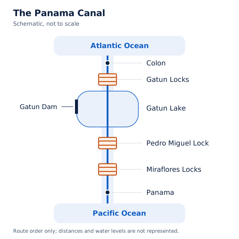
The map marks Colon near the Atlantic Ocean and Panama beside the Pacific Ocean. The canal route passes through Gatun Lake. Gatun Dam and locks, Pedro Miguel Lock and Miraflores Locks are labelled.
Drawn by One Young India. See Fig. 7.11 in your NCERT textbook
What determines the usefulness of inland waterways?
Inland waterways use rivers, canals, lakes and coastal areas to carry cargo and passengers in boats and steamers. Heavy loads include coal, cement, timber and metallic ores. Development depends on navigability, channel width and depth, continuous water flow and transport technology.
Navigability means suitability for the passage of vessels. River transport lost importance because railways competed with it, irrigation diverted water and maintenance was poor. Nevertheless, many rivers have been modified to improve navigation.
How can river navigation be improved?
- Dredging, the removal of material from the river bed, improves the navigable channel.
- Stabilising river banks helps maintain the river channel used for transport.
- Building dams and barrages, structures across rivers that regulate water, helps control flow.
- Regulating flow improves conditions for navigation and supports the river's use as a transport route.
These measures address physical limitations. They are related methods of improvement, rather than a compulsory construction sequence. A wide, deep river free of silt, or fine particles deposited by water, provides favourable conditions for inland water transport.
Why is the Rhine especially important?
The Rhine flows through Germany and the Netherlands and is navigable for 700 kilometres from Rotterdam to Basel. Ocean-going vessels reach Cologne. The Ruhr joins from the east through a rich coalfield and prosperous manufacturing region; Dusseldorf is its Rhine port.
This is the world's most heavily used waterway. Each year, more than 20,000 ocean-going ships and 2,00,000 inland vessels exchange cargoes. It connects industrial areas of Switzerland, Germany, France, Belgium and the Netherlands with the North Atlantic Sea Route.
Which other inland waterways are important?
| Waterway | Connection | Distinctive feature |
|---|---|---|
| Danube | Rises in the Black Forest and flows east through many countries | Serves Eastern Europe; exports include wheat, maize, timber and machinery |
| Volga | Drains into the Caspian Sea; canals connect it with Moscow and the Black Sea | Provides a navigable waterway of 11,200 km |
| Great Lakes-St. Lawrence | Connects the Great Lakes and the St. Lawrence estuary in northern North America | Duluth and Buffalo have ocean-port facilities |
| Mississippi-Ohio | Connects the interior United States with the Gulf of Mexico | Large steamers can reach Minneapolis |
On the St. Lawrence, ocean-going vessels reach Montreal. There, goods are trans-shipped, or transferred to smaller vessels, because of rapids. Rapids are stretches of fast, turbulent water. Canals up to 3.5 metres deep have been constructed to avoid them.
Why is air transport important despite its high cost?
Air transport is the fastest transport mode, but it is very costly. Passengers prefer it for long-distance travel, while valuable cargo can move rapidly worldwide. It is often the only way to reach inaccessible places.
Air transport overcomes obstacles created by mountainous snowfields and inhospitable deserts. In the Himalayas, landslides, avalanches (masses of snow sliding down slopes) and heavy snowfall often obstruct routes. At such times, air travel is the only alternative for reaching a place. Airways also have strategic importance.
What infrastructure does aviation need?
Aircraft manufacture and operation require elaborate facilities for landing, fuelling and maintenance, as well as hangars, buildings that house aircraft. Airport construction is very expensive. Airports have developed more in highly industrialised countries with large traffic volumes.
The United Kingdom pioneered commercial jet transport, while the United States largely developed international civil aviation after the war. Civil aviation means non-military air transport. The speed of air travel allows journeys to be measured in hours and minutes rather than years and months.
Where are intercontinental routes concentrated?
Intercontinental air routes form a distinct east-west belt in the Northern Hemisphere. Dense networks occur in the eastern United States, Western Europe and South-east Asia. Major nodal points include New York, London, Paris, Frankfurt, Moscow, New Delhi, Mumbai, Singapore and Tokyo.
These nodal points are places where routes converge or radiate towards continents. In the Southern Hemisphere, air services between 10 and 35 degrees of latitude are limited because of sparser population, limited landmass and economic development. Network distribution therefore reflects demand and development as well as technological capability.
What can pipelines carry, and where are they used?
Pipelines carry liquids and gases such as water, petroleum and natural gas in an uninterrupted flow. They are extensively used for these materials. They can also carry liquidified coal, while New Zealand uses pipelines to supply milk from farms to factories.
How do pipelines link production and consumption?
The United States has a dense oil-pipeline network between producing and consuming areas. The Big Inch carries petroleum from Gulf of Mexico oil wells to the north-eastern states. Its cargo is petroleum, which should be distinguished from natural gas or milk.
In Europe, Russia, West Asia and India, pipelines connect oil wells with refineries, ports or domestic markets. A refinery processes crude petroleum into usable products. Turkmenistan in Central Asia has extended pipelines to Iran and parts of China.
The international oil and natural-gas pipeline from Iran to India via Pakistan is proposed. Its status is part of the description: a proposed pipeline must not be presented as an already operating connection. Pipelines serve material flows rather than passenger journeys.
How have telecommunications and satellites changed communication?
Telecommunications transmit information over a distance. The telegraph and telephone were important long-distance methods. The telegraph helped the colonisation of the American West. The telephone became important in American urbanisation as firms centralised operations in city headquarters and established branches in smaller towns.
What did optical fibre change?
Telephone companies upgraded copper-cable systems with optical fibre cables, communication cables that transmit information using light. They allow large quantities of data to move rapidly and securely and are virtually error-free. This qualification does not mean completely free of errors.
With information being converted into digital form in the 1990s, telecommunications gradually merged with computers to form integrated networks called the Internet. This combined development connected communication systems with computer-based information exchange.
Why are satellites significant?
Artificial satellites, human-made objects placed in orbit around Earth, connect even remote parts of the globe. Satellite communication emerged as a new field from the 1970s, after the United States and the former Soviet Union pioneered space research.
Satellites make the unit cost and communication time invariant with distance, meaning unchanged by distance. Communicating over 500 kilometres therefore costs the same as communicating over 5,000 kilometres via satellite. Satellite communication supports long-distance communication, television and radio.
India launched Aryabhatt on 19 April 1975, Bhaskar-I in 1979 and Rohini in 1980. APPLE, the Arian Passenger Payload Experiment, was launched through an Arian rocket on 19 June 1981. These milestones form part of India's development of satellite technology.
The value of improved communication extends to remote connectivity and television weather forecasting. The ability to connect separated places rapidly changes how information reaches people, even where physical travel remains difficult.
What is cyberspace, and how does it expand human activity?
Cyberspace is electronic computerised space: the digital world in which people communicate or access information through computer networks without the sender and receiver moving physically. It is encompassed by the Internet, including the World Wide Web, a system of information accessible through it.
Cyberspace may be accessed from an office, sailing boat, flying plane or virtually anywhere. The electronic network has spread at an unprecedented speed in human history. Its growth expands the spaces in which economic and social relationships take place.
How has Internet use grown?
| Year | Internet users |
|---|---|
| 1995 | Less than 50 million |
| 2000 | About 400 million |
| 2010 | Over two billion |
| 2023 | About 5.4 billion |
The qualifiers less than, about and over matter: these values are not all exact counts. The United States' percentage share fell from 66 in 1995 to only 25 in 2005 as global use shifted towards developing countries.
Which activities expand through cyberspace?
E-mail means electronic mail; e-commerce is commerce through electronic networks; e-learning is learning through them; and e-governance is the use of electronic systems for governance. These are ways cyberspace will expand contemporary economic and social space.
The Internet, together with fax, television and radio, will reach more people across barriers of place and time. Modern communication systems, more than transportation, have made the global village a reality: distant populations become closely connected through communication.
Glossary
- Transport — A service or facility carrying people and goods between places using humans, animals or vehicles.
- Transport network — A pattern formed when places, called nodes, are connected by routes, called links.
- Freight — Goods carried as cargo by a transport service, as distinct from passengers.
- Highway — A metalled road connecting distant places and designed to facilitate unobstructed vehicular movement.
- Border road — A road along an international boundary that supports remote settlements and national defence.
- Transcontinental railway — A railway that runs across a continent and links its two ends.
- Coastal shipping — Transport by water along coasts, especially useful in countries with long coastlines.
- Shipping canal — An artificial navigable waterway that allows ships to move between connected water bodies.
- Navigability — The suitability of a waterway for vessels, related to channel dimensions and water flow.
- Trans-shipment — The transfer of cargo from one vessel to another during its onward journey.
- Pipeline — A transport system carrying liquids or gases between places in an uninterrupted flow.
- Cyberspace — Electronic computerised space where information is accessed or exchanged without physical movement of sender and receiver.
Common errors and misconceptions
- Misconception: The fastest transport mode is best for every load. Correct: Suitability depends on the goods, transport costs and available modes; well-managed systems use their complementary strengths.
- Misconception: Roads remain equally usable throughout the year. Correct: Unmetalled roads become unmotorable in rain, while even metalled roads are seriously affected by heavy rain and floods.
- Misconception: The Trans-Canadian Highway and Railway have identical endpoints. Correct: The highway links Vancouver and St. John's City; the railway links Halifax and Vancouver.
- Misconception: The Suez and Panama canals both use locks. Correct: Suez is a sea-level canal without locks. Panama has a six-lock system for crossing different levels.
- Misconception: Any river is equally suitable for inland transport. Correct: Navigation depends on channel width and depth, continuity of water flow and the transport technology used.
- Misconception: The Big Inch carries natural gas. Correct: It carries petroleum from Gulf of Mexico oil wells to the north-eastern states of the United States.
- Misconception: Optical fibre transmission is completely error-free. Correct: It is virtually error-free, a qualification that must be retained.
- Misconception: Every named international pipeline or railway is operational. Correct: The Iran-India pipeline via Pakistan and the Trans-Asiatic Railway connection are described as proposals.
Exam-style questions with model answers
Q1. A transport network consists of places connected by routes. Places are called nodes and routes are called links. Using this information, distinguish nodes from links in two points. [2 marks]
- Nodes are the places within a transport network that are connected to one another.
- Links are the routes joining these places, together forming the pattern of the transport network.
Q2. Roads are cheaper and faster over short distances and offer door-to-door service. Railways are most suited to large volumes of bulky materials over long distances within a country. Airways are best for high-value, light and perishable goods. Explain three ways these modes complement one another. [3 marks]
- Roads meet short-distance needs through cheaper, faster movement and door-to-door service, giving them a distinct role within the transport system.
- Railways are most suited to the different need to carry large volumes of bulky materials over long distances within a country.
- Airways are best for high-value, light and perishable goods, so their particular suitability complements the different roles of roads and railways.
Q3. Unmetalled roads become unmotorable in rain; even metalled roads are seriously affected by heavy rain and floods. Raised railway tracks and efficient maintenance offer an effective response, but limited railway length cannot serve vast developing countries at low cost. Explain these four points about transport reliability. [4 marks]
- Unmetalled roads lack all-season reliability because rain can make them unmotorable, interrupting their use by vehicles.
- Metalled roads also face serious limitations during heavy rain and floods, so their harder surface does not remove these difficulties.
- Raised railway tracks, together with efficient maintenance of railway services, provide an effective transport response in these conditions.
- Limited railway route length prevents this response from serving the needs of vast developing countries at low cost.
Q4. Suez links the Mediterranean and Red seas, is about 160 kilometres long, has no locks, shortens Liverpool-Colombo travel compared with the Cape route, and has greater economic significance than Panama. Panama links the Atlantic and Pacific oceans, is about 72 kilometres long, has six locks for crossing different water levels, shortens New York-San Francisco sea travel by 13,000 kilometres, and is vital to Latin America. Compare the canals in five points using these facts. [5 marks]
- They connect different water bodies: Suez joins the Mediterranean Sea to the Red Sea, while Panama connects the Atlantic and Pacific oceans.
- Their approximate lengths differ: Suez is about 160 kilometres long, whereas Panama is about 72 kilometres long.
- Their operation differs because Suez has no locks, while Panama uses six locks to allow ships to cross different water levels.
- Suez shortens the Liverpool-Colombo journey compared with the Cape route; Panama shortens the New York-San Francisco sea journey by 13,000 kilometres.
- Panama has relatively less economic significance than Suez, yet it is vital to Latin America. Relative significance does not imply that Panama is unimportant.
Q5. The 7,050-kilometre Trans-Canadian Railway links Halifax and Vancouver. Built in 1886 as part of an agreement for British Columbia to join the Federation of States, it connects the Quebec-Montreal Industrial Region, Prairie wheat belt and northern Coniferous Forest region. Its Winnipeg-Thunder Bay loop reaches Lake Superior, and wheat and meat are important exports. Explain its importance in five points. [5 marks]
- The 7,050-kilometre railway provides a long-distance connection between Halifax and Vancouver, joining its two endpoints through a single transcontinental rail route.
- Its construction in 1886 had political significance because it formed part of the agreement for British Columbia to join the Federation of States.
- It joins the industrial region, wheat belt and Coniferous Forest region, making regions with different economic activities complementary to one another.
- The loop from Winnipeg to Thunder Bay connects the railway with Lake Superior, linking rail transport to an important waterway.
- Wheat and meat are important exports along the route, showing that the railway has an economic role as well as its original political purpose.
Q6. Air transport is the fastest but very costly; passengers prefer it for long journeys, and valuable cargo moves rapidly. It is often the only access to inaccessible areas. Airports require expensive construction and facilities for landing, fuelling and maintenance. Explain two advantages and one limitation. [3 marks]
- Its high speed makes air transport attractive for long-distance passenger travel and the rapid movement of valuable cargo.
- It improves accessibility because it is often the only available means of reaching places that are otherwise inaccessible.
- Its high cost is a limitation, since airport construction and the facilities needed for landing, fuelling and maintenance are expensive.
Q7. Satellite communication makes unit cost and time invariant with distance: communicating over 500 kilometres costs the same as over 5,000 kilometres. State two implications, retaining the meaning of “invariant”. [2 marks]
- Unit communication cost is unchanged by distance, so the two stated distances have the same communication cost.
- Communication time is also unchanged by distance; “invariant” means that it does not vary with distance.
Q8. Internet users numbered less than 50 million in 1995, about 400 million in 2000, over two billion in 2010 and about 5.4 billion in 2023. Give four chronological observations, keeping each qualifier and making no exact growth calculation. [4 marks]
- In 1995, Internet use was below 50 million people; the phrase “less than” gives an upper boundary rather than an exact count.
- By 2000, the number was about 400 million, showing growth while retaining the approximate nature of the figure.
- In 2010, users exceeded two billion; “over” indicates that the total was greater than the stated number.
- By 2023, use had reached about 5.4 billion people, an approximate figure showing further expansion of the network.
Key takeaways
- Transport networks connect places through routes; their organisation includes vehicles, maintenance, loading, unloading and delivery services.
- Roads, railways, waterways, airways and pipelines serve different needs and complement one another in well-managed systems.
- Road transport offers short-distance economy and door-to-door service, but rain, floods and congestion can restrict its effectiveness.
- Transcontinental railways link distant regions and make different producing areas, industrial centres and markets complementary.
- Suez is a sea-level canal without locks, while Panama uses a six-lock system to cross different levels.
- Inland navigation depends on channel dimensions, continuous flow and transport technology, with modifications helping overcome limitations.
- Air transport combines high speed and improved accessibility with expensive airport construction and elaborate operating facilities.
- Satellite communication reduces the importance of distance, while cyberspace expands economic and social activity without physical movement.
Test yourself
What determines the significance of a transport mode?
The type of goods and services, transport costs and the available mode determine its significance.
Which places does the Trans-Continental Stuart Highway connect?
It connects Darwin and Melbourne in Australia through Tennant Creek and Alice Springs.
Why must “perhaps” be retained when describing the Stockton-Darlington line?
Its description is qualified: perhaps the first public railway line opened there in 1825.
Which sea route is called the Big Trunk Route?
The Northern Atlantic Sea Route, linking north-eastern United States with north-western Europe, is the Big Trunk Route.
When might some ships prefer the Cape Route to Suez?
Some find the longer Cape Route cheaper because of heavy canal tolls, whenever the consequent delay is not important.
Which regions have dense intercontinental air-route networks?
Dense networks occur in the eastern United States, Western Europe and South-east Asia.
How is New Zealand's pipeline example different from the Big Inch?
New Zealand uses pipelines for milk from farms to factories; the Big Inch carries petroleum.
Through which activities will cyberspace expand economic and social space?
It will expand these spaces through e-mail, e-commerce, e-learning and e-governance over electronic networks.
Write about it
Turn a question from this chapter into a paper.
The Writing Studio has a structure guide, a rubric and citation tools for 15 formats, from essays to research papers. Drafting is free with an account. Learnacy Essential adds feedback from an AI writing coach and submission to The OYI Review.
Learnacy Essential is ₹1,499 for the year. Publication depends on review and is not guaranteed.